OpenStreetMap logo OpenStreetMap

Users' Diaries

Recent diary entries

Posted by alan_gr on 31 October 2024 in English. Last updated on 28 July 2025.

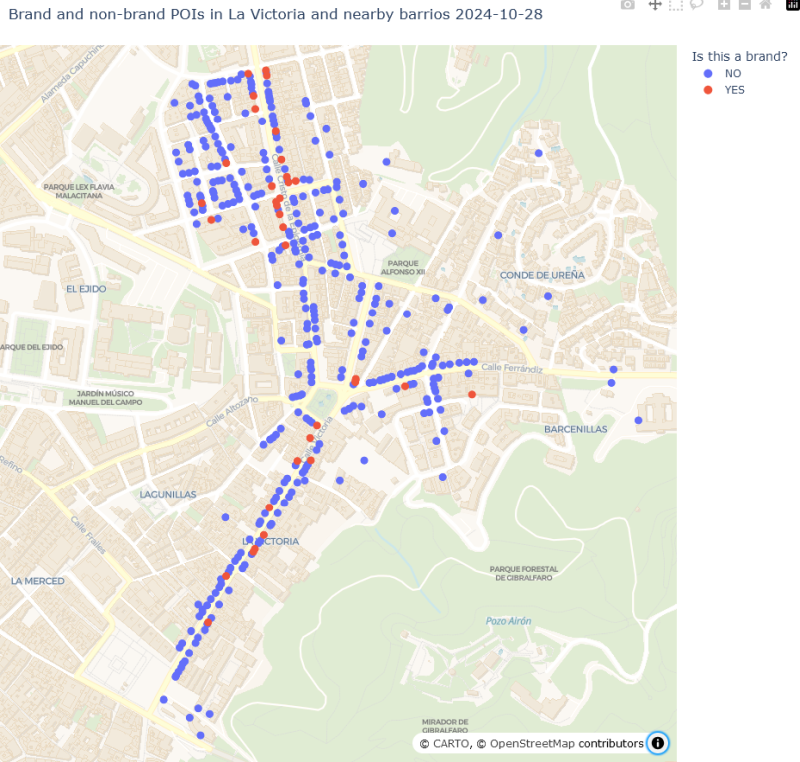
As I mentioned in Parts 1 and 2, over the last couple of months I set out to systematically update Points of Interest in four adjoining barrios in the city of Málaga.

A few businesses really did open, close, or change hands over that short period. But the vast majority of the changes in the data reflect the OSM data “catching up” with reality: adding points that had never been mapped in OSM, or updating POIs that had changed in some way since they were last touched by an OSM mapper.

Adding leisure POIs

Closely examining changes over a period is a good way of revealing faulty assumptions. I noticed that three shop locations had disappeared from my data, even though I was sure there were still businesses at those addresses. They are all gyms now, and gyms are tagged as “leisure” - a tag I had completely ignored. I’ve now added leisure POIs. As with “amenity” tags, I excluded some high-volume tags such as “garden” and “swimming pool”. I now have 392 POIs in my current dataset, not 376 as I mentioned in previous diary entries.

Changes over the period

  POI count count distinct feature tags
mid Aug 2024 267 96
+ newly created 141 34
- removed (16) (9)
late Oct 2024 392 121
% change +47% +26%

I mentioned in a previous post that I thought that POIs were reasonably well mapped in this neighbourhood. The numbers suggest that about two thirds of POIs were mapped two months ago. That seems respectable, but not great. There has not been any major expansion of retail space in this area recently. Some of the new additions are locations that were vacant or derelict when the area was first mapped in detail, but the majority have existed for a long time and were simply never mapped in OSM.

See full entry

Location: Cristo de la Epidemia, Centro, Málaga, Málaga-Costa del Sol, Malaga, Andalusia, Spain

Este é o nono entre os diários de campo que compõem o caderno de campo da minha pesquisa sobre interações sociotécnicas nos Altos e Córregos da Zona Norte do Recife e sua área contígua em Olinda, cidades localizadas na Região Metropolitana do Recife (RMR). Mais detalhes sobre a pesquisa vocês podem ver na minha tese de doutorado, publicada em https://repositorio.ufpe.br/handle/123456789/48802. Para a tese a delimitação socioespacial foram os Altos e Córregos da Zona Norte do Recife, a parte de Olinda foi agregada depois da tese.

Os diários de campo foram realizados em minhas idas ao território objeto de estudo. Nessas idas sempre registrei o percurso com o aplicativo OSM Tracker. Este é o track da minha ida ao Alto Santa Terezinha, Recife/PE, em 23/04/2024 http://u.osmfr.org/m/1060051/

alt=alto santa terezinha mapa

See full entry

Location: Alto Santa Teresinha, Recife, Região Geográfica Imediata do Recife, Região Metropolitana do Recife, Região Geográfica Intermediária do Recife, Pernambuco, Região Nordeste, Brasil

Este é o oitavo entre os diários de campo que compõem o caderno de campo da minha pesquisa sobre interações sociotécnicas nos Altos e Córregos da Zona Norte do Recife e sua área contígua em Olinda, cidades localizadas na Região Metropolitana do Recife (RMR). Mais detalhes sobre a pesquisa vocês podem ver na minha tese de doutorado, publicada em https://repositorio.ufpe.br/handle/123456789/48802. Para a tese a delimitação socioespacial foram os Altos e Córregos da Zona Norte do Recife, a parte de Olinda foi agregada depois da tese.

Os diários de campo foram realizados em minhas idas ao território objeto de estudo. Nessas idas sempre registrei o percurso com o aplicativo OSM Tracker. No dia 03/10/2023 fui para o Alto do Rosário. Dessa vez não fui por demanda do meu projeto de pesquisa nos Altos e Córregos da Zona Norte do Recife e área contígua de Olinda. Mesmo assim, resolvi ligar o aplicativo OSM Tracker para o registro e fazer algumas observações. Pude fazer um percurso longo dentro da minha área de interesse, pois na ida fui por Recife e voltei por Olinda http://u.osmfr.org/m/968423/

See full entry

Location: Dois Unidos, Recife, Região Geográfica Imediata do Recife, Região Metropolitana do Recife, Região Geográfica Intermediária do Recife, Pernambuco, Região Nordeste, Brasil

Este é o sétimo entre os diários de campo que compõem o caderno de campo da minha pesquisa sobre interações sociotécnicas nos Altos e Córregos da Zona Norte do Recife e sua área contígua em Olinda, cidades localizadas na Região Metropolitana do Recife (RMR). Mais detalhes sobre a pesquisa vocês podem ver na minha tese de doutorado, publicada em https://repositorio.ufpe.br/handle/123456789/48802. Para a tese a delimitação socioespacial foram os Altos e Córregos da Zona Norte do Recife, a parte de Olinda foi agregada depois da tese.

Os diários de campo foram realizados em minhas idas ao território objeto de estudo. Nessas idas sempre registrei o percurso com o aplicativo OSM Tracker. Esse diário diz repeito a ida para o Córrego do Abacaxi - Alto da Macaíba - Alto da Bondade - Alto da Sucupira, Olinda/PE, em 30/05/2023. Neste link, na camada de linhas na cor indigo, está o registro do percurso realizado no dia http://u.osmfr.org/m/922236/

alt=print mapa umap

See full entry

Location: Alto da Bondade, Olinda, Região Geográfica Imediata do Recife, Região Metropolitana do Recife, Região Geográfica Intermediária do Recife, Pernambuco, Região Nordeste, 52170-630, Brasil
Posted by TheFighter137 on 30 October 2024 in English. Last updated on 1 November 2024.

This is the first time I try micromapping in OSM. It took quite a while to learn the appropriate tags for some amenities, but I got there in the end. For a first, I decided to focus on an open area I know very well, which is a square in my hometown. I didn’t do much in terms of area coverage, but it is still pretty noticeable. By the way, if you want to check if I’ve done my job correctly, please note that less than one year ago, all hedges and trees that surrounded the square were torn down ; no idea why considering it looked awesome, now it is pretty dull and flat.

Here’s what it looks like, and considering how it is rendered, I can’t resist feeling proud : Image

Location: Ferme Fouquet, Le Bourgthéroulde, Etennemare, Saint-Valery-en-Caux, Dieppe, Seine-Maritime, Normandy, Metropolitan France, 76460, France

It seems that I tend to forget to publish my daily diary entry on time ; I’ll do my best to do so, even for light workloads

Yesterday, I rode my bicycle to check on-site issues that I noticed with addresses in Saint-Valery-en-Caux. I managed to fix them all, and to map a few fire hydrants as well.

I wish to thank the OsmAnd team for their app : this diary entry was possible thanks to them and their app. Features such as audio/video notes and offline OSM notes were very helpful during this bicycle ride.

Location: Ferme Fouquet, Le Bourgthéroulde, Etennemare, Saint-Valery-en-Caux, Dieppe, Seine-Maritime, Normandy, Metropolitan France, 76460, France

Este é o sexto entre os diários de campo que compõem o caderno de campo da minha pesquisa sobre interações sociotécnicas nos Altos e Córregos da Zona Norte do Recife e sua área contígua em Olinda, cidades localizadas na Região Metropolitana do Recife (RMR). Mais detalhes sobre a pesquisa vocês podem ver na minha tese de doutorado, publicada em https://repositorio.ufpe.br/handle/123456789/48802. Para a tese a delimitação socioespacial foram os Altos e Córregos da Zona Norte do Recife, a parte de Olinda foi agregada depois da tese.

Os diários de campo foram realizados em minhas idas ao território objeto de estudo. Nessas idas sempre registrei o percurso com o aplicativo OSM Tracker. Esse diário diz repeito a ida para o Alto do Eucalipto, no bairro do Vasco da Gama, Recife/PE, em 13/04/2023

alt=track eucalipto 13042023

See full entry

Location: Vasco da Gama, Recife, Região Geográfica Imediata do Recife, Região Metropolitana do Recife, Região Geográfica Intermediária do Recife, Pernambuco, Região Nordeste, Brasil

Este é o quinto entre os diários de campo que compõem o caderno de campo da minha pesquisa sobre interações sociotécnicas nos Altos e Córregos da Zona Norte do Recife e sua área contígua em Olinda, cidades localizadas na Região Metropolitana do Recife (RMR). Mais detalhes sobre a pesquisa vocês podem ver na minha tese de doutorado, publicada em https://repositorio.ufpe.br/handle/123456789/48802. Para a tese a delimitação socioespacial foram os Altos e Córregos da Zona Norte do Recife, a parte de Olinda foi agregada depois da tese.

Os diários de campo foram realizados em minhas idas ao território objeto de estudo. Nessas idas sempre registrei o percurso com o aplicativo OSM Tracker. Esse diário diz repeito a ida para o Alto do Eucalipto, no bairro do Vasco da Gama, Recife/PE http://u.osmfr.org/m/853346/.

Na tarde do dia 05/01/2023, fomos ao Alto do Eucalipto, no bairro do Vasco da Gama, Zona Norte do Recife, para observarmos uma mudança em uma das paisagens que registramos para a nossa tese. O local, um passeio, localizado na Rua Camboriú, abrigava uma lixeira construída pelos próprios moradores, a partir de carcaças de duas máquinas de lavar. No momento do registro inicial, dia 09/03/2022, entendemos que aquele era um objeto técnico importante pra ser registrado. No final de 2022, um dos entrevistados morador da localidade, me informou que as lixeiras foram retiradas e em seu lugar o passeio foi requalificado, com estruturas que atendem principalmente o lazer das crianças.

See full entry

Location: Vasco da Gama, Recife, Região Geográfica Imediata do Recife, Região Metropolitana do Recife, Região Geográfica Intermediária do Recife, Pernambuco, Região Nordeste, Brasil
Posted by jacopofar on 29 October 2024 in English.

This year the weather has been quite awful in Milan, and Sunday 20th it was raining once again. However, later during the day it was nice and even sunny, so I decided to go for another trip.

This time I planned in advance and went to Villaggio dei giornalisti, an area that was not particularly covered by previous footage. It is an area of architectural interest and particularly nice.

After that, I went back to the Parco Nord, covering more bike paths in the park.

This time I configured the camera correctly to record a time-lapse, getting around 4 GB of videos for a 2h trip, a much more reasonable file size. The battery also lasted longer, more than 2h and could have gone for much longer. I had to end my trip because it was getting dark.

Another thing I learned from the previous time was to use a fitness tracker to track my trip, so now I can see the calories and speed overall, and observe the trip later on Strava. I also could produce a GPX track, but they are already abundant on OSM in this area.

I still have to figure out an effective way to micromap based on these pictures, iD integrates with Mapillary but the interface is a bit cumbersome for large changes, currently I find easier to open another window with the footage only.

Location: Maciachini - Maggiolina, Municipio 9, Milan, Lombardy, Italy
Posted by alan_gr on 28 October 2024 in English. Last updated on 28 July 2025.

Brands

As part of my systematic update of local POIs (see Part 1), I added the “brand” and “brand:wikidata” tags wherever I could identify them. Before I started I thought I might find quite a few POIs that I had not previously recognised as brands.

Spoiler: I was wrong, yet again. It’s good to have your preconceptions challenged by actual data. I guess.

It turned out that the reason I hadn’t heard of most of the brands displayed on POIs in this area, and the reason not many POIs had the brand tag before I started mapping, was that … they aren’t brands. It’s possible there are a few shops belonging to brands so obscure or localised that I couldn’t find any reference to them online, but I don’t think I can have missed many.

Out of 376 POIs, only 36 - less than 10 percent - are now tagged as brands.

map of POIs with multiple colours distinguishing different types of POI

See full entry

Location: Cristo de la Epidemia, Centro, Málaga, Málaga-Costa del Sol, Malaga, Andalusia, Spain
Posted by alan_gr on 28 October 2024 in English. Last updated on 28 July 2025.

Recently I have been trying to systematically improve OSM data about shops, businesses, and other Points of Interest in a small area of my city. Like many OSM contributors before me, I have been torn between the desire to make my local map as complete as possible, and the realisation of just how much time is needed to do that. My observations in the following series of diary posts may not be very original, but perhaps they’ll help me to clarify my thoughts on the subject.

Background

Málaga is divided into about 200 barrios or neighborhoods, all with well-defined boundaries in OSM. I chose to focus on an area of four adjoining barrios slightly to the northeast of the historic centre. The main axis of this area, formed by Calle Victoria and Calle Cristo de la Epidemia, is about 1km long (the green dashes in the map below). These main thoroughfares, and many of the smaller streets, are lined by apartment blocks with commercial premises on the ground floor. The hillier areas to the east are more purely residential. Most shops are quite small, many are sole traders, and there are no shopping malls.

See full entry

Location: Cristo de la Epidemia, Centro, Málaga, Málaga-Costa del Sol, Malaga, Andalusia, Spain

I finished solving my personal OSMose issues (mainly level 3) and other ones in municipalities around Saint-Valery-en-Caux.

To correctly tag some services, I needed to use Pifomètre for two municipalities.

I also fixed a few issues in OSM Inspector around Saint-Valery-en-Caux and Rouen, although it is pretty difficult to understand what’s wrong sometimes.

Another OSM user rightfully told me that one edit I did on bus lanes in Rouen was wrong in terms of tags, so I managed to correct it.

Posted by Zkir on 27 October 2024 in Russian (Русский). Last updated on 28 October 2024.

План был выпускать по одной 3d-модели каждую неделю, пока немного отстаю.

Тем не менее, запилил еще одно здание, и опять наземный вестибюль станции метро. В этот раз это метро Новокузнецкая, еще один шедевр сталинского ампира. Злые языки конечно могут сказать, что это больше пост-конструктивизм, чем ампир. Возможно.

Наземный вестибюль станции метро Новокузнецкая

На F4 она показывается непокрашенная, ну да ладно. Полноценные текстурированные модели бродят где-то совсем рядом.

P.S. Заказы на здания по прежнему принимаются.

You may know that the preparations for this year’s OpenStreetMap Kerala Annual Meetup have started. We had a meeting on the 20th to find a suitable venue and date and to brainstorm related matters and form a working group for the same.

OpenStreetMap Kerala Community Logo

It has now been decided to hold the annual gathering of 2024 on November 16-17 at Kerala Veterinary and Animal Sciences University, Wayanad district.

Venue and Registration - Travel Scholarship - Participatory details will be updated by the responsible volunteers in the coming days.

See full entry

Location: Pokkode Diary Colony, Pookode, Vythiri, Wayanad, Kerala, 673576, India

I decided to fix, once again, all of the issues attributed to me by OSMose. I managed to fix almost all of them for levels 1 and 2. I’ll probably fix the level 3 ones tomorrow.

Today, I also discovered the OSMose map. I already knew about the website itself, but only on its personal list form. Therefore, I decided to fix almost all the issues in my hometown, Saint-Valery-en-Caux. I briefly also fixed issues in Rouen and Barentin.

I won’t add the links of my changesets anymore, as I’m too lazy to do so (lol).