রাজশাহী জেলার বাগমারা উপজেলার যোগীপাড়া ইউনিয়নের কাতিলা গ্রামে অবস্থিত নাগা বাজার–মুলিভিটা সংযোগ সড়কটি মাঠপর্যায়ের তথ্য ও স্থানীয় জ্ঞানের ভিত্তিতে মানচিত্রে সংযোজন করা হয়েছে।
Diary Entries in English
Recent diary entries
আজ আমি OpenStreetMap-এ নাগা বাজার এলাকায় “Naga Vila” নামে একটি আবাসিক বাড়ি যোগ করেছি। লোকাল জ্ঞানের ভিত্তিতে building=house ট্যাগ ব্যবহার করে পয়েন্ট হিসেবে ম্যাপ করা হয়েছে।এতে এলাকার আবাসিক ম্যাপিং আরও সঠিক হবে।

Last night, I added Arbela, MO, and some geometry in the immediate vicinity. It’s the next village west of Granger, MO.
Today, I did a quick walk for a GPS trace, and then I came home and added some more geometry around Arbela. Unfortunately, I managed to get JOSM into a bad state before uploading, and I decided to start this evening’s changes over again. Alas. It’s almost bedtime, but I was able to redo the buildings and the driveways I’d done before. The water will have to wait until tomorrow.
Merry Mapmas!
আজ OpenStreetMap-এ আমার একটি নতুন অবদান যোগ করেছি। নাগা বাজার এলাকায় অবস্থিত “Naga Bazar Shopping and Service Centre” মানচিত্রে যুক্ত করা হয়েছে। এই স্থাপনাটি স্থানীয়ভাবে পরিচিত একটি শপিং ও সেবা কেন্দ্র, যা আগে মানচিত্রে উল্লেখিত ছিল না।
এই তথ্যটি আমি স্থানীয় জ্ঞান ও পর্যবেক্ষণের ভিত্তিতে যোগ করেছি এবং ভবিষ্যতে আশপাশের অন্যান্য গুরুত্বপূর্ণ স্থান ও সড়কের তথ্য যাচাই করে ধাপে ধাপে যুক্ত করার পরিকল্পনা রয়েছে। অভিজ্ঞ ম্যাপারদের যেকোনো পরামর্শ বা সংশোধনকে স্বাগত জানাই।
Content removed by author

We haven’t had a London pub meet-up in a while. I probably could’ve organised something, but got waylaid by Dundee, and preparing a talk for Dundee, and recovering from all the excitement of Dundee. But of course we need to squeeze a pub meet-up before Christmas…
The Xmas OSMLondon pub meet-up is TONIGHT!
Dundee? I mean State Of The Map EU in Dundee of course. Great fun was had by me.

Here’s me at the kick off session, not quite managing to do my usual mega-cheerful grin, because I had to get up a bit too early off the sleeper train. More of a normal smile. And I’ve slapped some photos on instagram.
Instagram isn’t a proper way to do these things, but they’re not really proper photos. Just my crappy snaps. The official photographer shots will appear somewhere better I hope. Maybe the wikimedia commons category. OK I’ll photobomb that with one of mine :-)
I’m kicking myself for not celebrating Mapmas, since I apparently signed up on December 1st. :) Alas.
Well, I’m retconning it, so Merry Mapmas 2025! I know, the staunch Anglicans in the crowd would (rightfully) say: “But shouldn’t it be Mapvent?” And they would be right! But I’ve already typed the title and these two paragraphs, so on we go!
Remote work
I added Granger, MO last night and this morning. It’s the next village to the west after Luray, MO, which the delightful UnmappedSmallTownUSA bot posted the other day. Someone had already done Luray, but there are several municipalities nearby that are unmapped, and Granger was the first one I saw.
This was my first time adding an entire place, and from imagery, too. Some of the buildings were skewed, so I had to trace roof outlines and then position them correctly to correspond to where they ought to actually be. Granger is also quite wooded, and there were areas where I wasn’t sure if it should count as natural=wood or not. I used my best judgement there.
There might be one or two structures or ponds outside of the official Granger boundary that I’ve missed, so I’m going to check on that tonight or tomorrow. Then, I’ll map Arbela, another village directly west of Granger.
I’ve really enjoyed getting out in the sun and mapping stuff in my own community, but it was nice and zen to hang out with a friend late last night and trace buildings and ponds in Granger.
In-office
I took a couple GPS traces today. Old Towne Orange in particular is missing most of its sidewalks, it seems. Once I convince myself that I’m not going to misplace a bunch of them, I plan to add them in, with appropriate crossings and such. While still doing doorbells. And I should add some more fire hydrants soon… There really aren’t enough hours in the day heh. If only I could get paid to wander around town all day mapping things. That might actually be the dream.
Merry Mapmas!
Bell Island, Newfoundland has now been practically fully mapped. There were some features that I was not able to fully map since it would have required local knowledge, however I’m happy with the extent of what was able to be mapped based off of satellite imagery alone.
With some reflection I think the scope of this project was quite large but still manageable since I didn’t put any strict timelines on myself. In the future I’ll likely choose slightly smaller scale projects where the whole thing can be wrapped up within a couple of months. In the interim I’ll probably map some of the smaller islets around Conception Bay.
Posted by PizzaTreeIsland on 15 December 2025 in English.
Recently, I started adding a large number of roof:colour tags to buildings that had previously lacked this information. I started in Colorado Springs for no particular reason, but I plan to expand this activity further. For reasons I will explain later, starting and then continuing with American suburbia is easier than mapping other regions, but in theory, my approach would work world wide. For this mapping activity, I developed my own processes along with some little software helpers, that people on the OSM World Discord were interested in when I mentioned them. So without further ado, here is everything you need to know about my roof colour related activities.
Motivation
So why am I doing this to myself? The most honest answer would probably be “more data, more better”, which is mostly why I do any of the things I do on OSM, but there are two more concrete possible applications for the data I add: Art and science.
Today is the first day of the AFRIGIST Alumni OSM TRAINING program. I serve as the assistance surveyor of the Redeemed Christiane Church of God
The AFRIGIST Alumni International Network Online Training Workshop on “OpenStreetMap: From Global Action to Local Impact – Leveraging Open Map Data for the SDGs” was successfully delivered, with over 30 participants and trainees joining from different AFRIGIST alumni beneficiary countries across Africa. It was a 2-days workshop held on 15th and 16th December,2025.
The training was facilitated by Dr. Victor Ndubuisi Sunday, Ph.D., Senior Lecturer, Geography & Environmental Management, University of Port Harcourt, and National Coordinator, Unique Mappers Network, who served as the Resource Person for the programme.
🔹 Training Highlights
Day 1 focused on core concepts and foundational skills, introducing participants to OpenStreetMap (OSM) as a global, open, community-driven geospatial platform and its relevance to local development and the Sustainable Development Goals (SDGs). Sessions covered OSM account creation, OSM Diary use, hands-on mapping with the iD Editor (roads, buildings, POIs), the Map My Village / Map My Community campaign, the HOT Tasking Manager, and best practices in data quality and validation.
Day 2 emphasized advanced and applied workflows, exposing participants to:
Downloading OSM data using Geofabrik and QuickOSM
Loading and managing OSM layers in QGIS
Map visualization and styling

What a treat -30.6743046,26.7295793 http://conville-farm.com/
It was a nice day. I think I just added more cameras. I also saw several cats, and a very excited dog who ran over to the fence to jump up and say hi. A nice day, indeed.
I also noticed that one of the house numbers on the north side of E Culver Ave seems to be out of order with the rest. The house numbers go: 537, 543, 555, 605, 569, 577. 605 is between 555 and 569, which doesn’t make sense. 618 is across the street, and starts the even-numbered 600 houses. Was it meant to maybe be 565 and some clerical error happened? Is it even a mistake at all or is this something deliberate? I have no idea, but it definitely threw me. I wonder if they struggle to receive packages.
I have to mapping projects I’m doing here. The first one, the one that has most of my focus is my home community of Fairview, California. The other is Canonsburg, Pennsylvania. For both projects I rely on a variety of tools:
- the Bing visual
- Google maps
- County GIS records
While Google has good data most of the time, I have spotted a couple dozen errors since I’ve started on these projects. When I can easily submit a correction to them, I do. When I can’t, I make sure my work better reflects what the county map tells me.

A few kilometers from the town of Luncavița in Tulcea County, tourists visiting the Măcin Mountains National Park can stop off in Cetățuia hamlet — a paradise for beekeepers who have brought bees to the linden forests (that define this hamlet) and for tourists who want to stay in a quiet place, next to the mountains, as this is the only locality in Tulcea County that resembles a mountain village. However, it didn’t have detailed OpenStreetMap coverage, until now. We have mapped this area in detail and are pleased to announce that the map is complete. You can view the before-and-after images below.
Before detailed mapping

নাগা বাজার — বীরকুৎসা সড়ক আমাদের দেখায় কীভাবে একটি ছোট স্থানীয় পথ থেকে বৃহৎ পরিবর্তন ও উন্নয়নের সম্ভাবনা তৈরি হতে পারে। এটি কেবল পথ নয়—এখানে মানুষের জীবিকা, সংস্কৃতি, অর্থনীতি ও দৈনন্দিন জীবনের রক্ষাকবচ লুকিয়ে আছে। সঠিক পরিকল্পনা, স্থায়ী রক্ষণাবেক্ষণ, স্থানীয় অংশগ্রহণ ও পরিবেশের সঙ্গে সমন্বয় রেখে উন্নয়ন করলে এই ৩ কিলোমিটার পথ পুরো এলাকাকে নতুনভাবে সংজ্ঞায়িত করতে পারে। রাষ্ট্রীয় তহবিল, স্থানীয় সরকার ও গৃহস্থালি উদ্যোগ মিলিয়ে এই সড়কটিকে শুধু চলার পথ না রেখে একটি স্থায়ী উন্নয়নের কাঁচা-সহজ রিংক হিসেবে গড়ে তোলা যেতে পারে—যা আগামী প্রজন্মের জন্য উন্নত সুযোগ ও জীবিকা তৈরি করবে।
Orange is pleasant to walk around. The houses are unique and interesting, the people are friendly, and sometimes there are dogs outside you can say hi to (and I say hi to every single one). Even in the quieter neighborhoods, it’s still a lively place. At least, during the day.
At night, it’s perfectly quiet and still. Because of this, I like to walk around at night; sometimes to help digest a large meal, sometimes just to think a bit before bed. Despite the solitude, I don’t feel entirely alone, because I’m being watched by a network of doorbell cameras. Some of them are set far enough back that I’m pretty sure they can’t see me. Others are close enough that they come alive and emit a faint glow when I walk by. Can they see in the dark? Does someone get a push notification alerting them to my presence? I’m not breaking the law, but it feels like I am.
I’m interested in privacy rights, and how technology makes it easy to surveil entire groups of people, always without their consent. I believe that people have a right to know when they’re being watched, and by whom, at least as long as recording in public remains legal. To that end, I’m starting to map doorbell cameras.
I did some research beforehand to see what the community thinks of mapping private objects. I’m still new, and I want to make sure I contribute in a way that is welcome and helpful. The Good practice page also reads: “Be brave in what you add…”
I read the Mapping private information wiki page. As far as I can tell, nothing there explicitly prohibits doorbell camera mapping. I believe I can also satisfy verifiability requirements: someone with a reasonably up-to-date prescription could stand on the same sidewalk and verify that these devices exist at a given location.
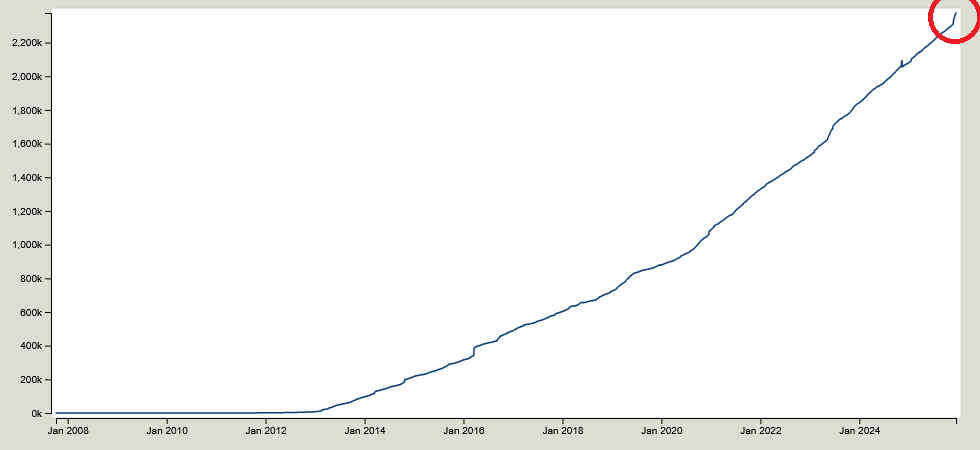
I also found a forum thread with some lively debate. The arguments I read in favor were convincing. Then, I checked the map, which had 1,121 camera:mount=doorbell tags, some of which go quite far back.

Peta Bencana Banjir Kabupaten Aceh Tamiang

Current wiki guidance for tagging slipways (leisure=slipway) is as follows:
A typical mapping might be to make a short highway=service way to the water’s edge and make the final node a leisure=slipway.
The highway=service that is part of the physical slipway is often further refined with a service=slipway. Keep in mind though that this does not replace leisure=slipway, mapped as a node on the end of that way.
Some mappers instead tag the whole way as leisure=slipway without using a highway=* tag, or sometimes in combination with highway=service (here service=slipway can be applied as well as above).
In other words there are two options (the first being implicitly preferred)
Option 1 - tag the node
- way: highway=service + service=slipway
- final node: leisure=slipway
Option 2 - tag the way
- way: leisure=slipway + optional highway=service + service=slipway
- final node: not tagged
The map marks an icon for both nodes and ways tagged with leisure=slipway. It’s therefore likely not advisable to do both. But which one is preferable?
There is some discussion about this on the wiki but no apparent resolution and it appears to refer to previous versions of the guidance: osm.wiki/Talk:Tag:leisure%3Dslipway
Though there is a question raised about wether leisure=slipway should be replaced by highway=service + service=slipway outright, especially given not all slips are for leisure use. But the map only marks an icon for leisure=slipway so this is likely not recommended.
Status quo
I wrote a script to analyse the data from of an area on the south east coast of Scotland.
https://overpass-turbo.eu/s/2hdk
The results:
- 45: option 1 (includes 16 orphaned nodes with no way)
- 62: option 2
So option 2 appears to be preferred, however it results in the map icon being placed at the mid point of the slip.
For ways that are correctly scoped to just the sloped slipway, this is probably ok. Longer ways should be split anyway.

To edit an OpenStreetMap (OSM) diary entry, you must navigate to the specific post while logged into your account.

Steps to Edit Your OSM Diary
- Log in to your account on OpenStreetMap.org.
- Click on your username in the top right corner to go to your user profile.
- Click the “New Diary Entry” link (usually located in the menu tab just below your username).
- Find the specific entry you want to change and click on its title to open the full post.
- Scroll to the bottom of the post text; you will see an “Edit this entry” button.
- Click it to open the editor, make your changes, and hit Save.