bxl-forever's Comments
| Changeset | When | Comment |
|---|---|---|
| 145632235 | almost 2 years ago | Hello, Thanks for the initiative.
1) Pedestrians walking across the tunnel are routed across the two elevators. 2) The connector between the elevator and the platform requires going through stairs, which is very unlikely. Do we want us to repair this? |
| 146453662 | almost 2 years ago | That’s right, the online editor, which is a very limited piece of software, does not have it. I am used to type tags manually. In the online editor you can achieve this by scrolling down to the "Tags" box. |
| 146453662 | almost 2 years ago | Hello, Thanks for this. Your description is very clear, thanks. In such a situation, the recommended tag is "bicycle=use_sidepath". This is because routers will always consider that "bicycle=no" means a complete no. But there are some cases where a cyclist may legally use the main road (for instance when this is the only possibility to do a left turn). Good navigation software know the difference, so we suggest you’ll change it into bicycle=use sidepath, it is safer. For this road, it looks like it won’t make a huge difference but it’s a good habit to take anyway. Hope this helps. Happy mapping! |
| 146445824 | almost 2 years ago | Hi,
|
| 146351971 | almost 2 years ago | Bonjour, Merci pour les changements mais quelques questions quand même. Comme vous vous présentez comme le compte officiel de cartographie de l’ULB nous allons supposer que vous êtes des experts en cartographie, aptes à comprendre ceci : 1) Pourquoi les contours de ces bâtiments ne sont pas tracés sur UrbisAdm ? On dirait que vous les avez dessinés sur photos aériennes et il y a de grosses différences de formes. Comment expliquer ce choix ? 2) Pourquoi garder la référence UrbIS sur celui-ci en lui donnant une autre forme ? way/121794864 Ça invalide la coordination entre les données UrbIS et OSM. Avez-vous reçu des données spéciales d’UrbIS avec d’autres numéros ? Nous n’avons pas retrouvé ces données dans la dernière version connue. Have a nice day. |
| 146370356 | almost 2 years ago | Hello, Sorry but your edit has been reverted. It *looks* like a roundabout but there are traffic signals and this creates different traffic rules from common roundabout. It is important that OSM contains correct data, therefore junction=roundabout is not applicable here. |
| 146299139 | almost 2 years ago | Well done, thanks! |
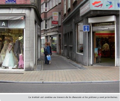
| 146299139 | almost 2 years ago | Hello, Are there road markings at all across this crossing? I am asking because you removed the "crossing" key entirely, so it will now always be flagged as having incomplete data. We can set it as "crossing=unmarked", if the situation is a bit like in this example: http://velobuc.free.fr/images/trottoirtraversant10.jpg Thanks. |
| 146222866 | almost 2 years ago | Hello, There is sadly no good system to mark some changes as temporary. If you are familiar with the place, the best way is if you can remember to edit the map after the works are finished. For the note tag, leaving a public note is possible (but I wouldn’t recommend this; the note system has been abused so much that we are currently overwhelmed with thousands of open notes asking for our attention). I was merely talking about the note *tag* attached to objects, such as roads. This is a free text that can be added to any object, and is aimed at fellow contributors. We can easily query the database to get all the streets with a note. In the iD editor, there is a text box with "Add field" and you can look for "Note". Here is an example:
|
| 146222866 | almost 2 years ago | Hello, Thanks for this. Just a word of warning here: * If the works are for a short duration (a few days, something like up to 3-4 weeks) we don’t change the map. Do you know how long the temporary situation is expected here? * Fill the note tag on the ways you change to write that it is temporary. Those will show up in Q/A apps and raise the attention of other mappers. Otherwise, we have no way to tell why/how those streets changed. (Too often, mappers edit the map and forget to undo their changes when the works are finished, which results in broken navigation for months or possibly years until someone notices.) * Make sure to verify whether one-way applies to everyone. Very commonly, one-way streets have white signs allowing cyclist to use contraflow. This is reflected by adding "oneway:bicycle=no" which is used by all routing apps and by the cycle map. It is very rare to have "pure" one-way streets in Brussels nowadays, even though that happens during roadworks. Happy mapping. |
| 146222173 | almost 2 years ago | Hello and welcome to OSM. Thanks for adjusting the speed limit. Indeed, the Brussels Region is now gradually phasing out the exception regime for boulevards that kept a 50 km/h limit after January 2021. Looks like we failed to notice this one. Just one thing: tags in OSM are usually nested, so if we say "maxspeed=50" we usually put an additional tag stating where this limit comes from, and we use the "source:maxspeed" tag. If you use the online editor, you can see that in the list of tags at the bottom of the editing window. For this case, since 50 km/h is not the official speed limit in the Brussels Region, maxspeed=50 was associated with having C43 road signs everywhere. We map this as "maxspeed=50" + "source:maxspeed=sign". If the authorities remove the road signs, the new speed limit becomes "maxspeed=30" indeed, but we also adjust the other tag, which becomes "source:maxspeed=BE-BRU:urban". This is a standard tag to confirm that the speed regime here applies the default value. I understand this is a very technical explanation. Don’t worry, I’ve already cleaned this up and fixed the tags on all the roads you have been editing. Don’t let this intimidate you, we are all learning every day. Happy mapping. |
| 146183069 | almost 2 years ago | Thanks for this. Some advice for next time: make sure to upload changes shortly after entering them into the app. As you can see, apparently they stayed on your device and after some time the queue contained both the restaurant in Middelkerke and the bicycle stands in Brussels, which created this huge bounding box. Happy mapping. |
| 146157271 | almost 2 years ago | User added roads in Shangai and this rock in the north of Scotland: way/1238944755 Changes in places far away from each other should be uploaded separately.
|
| 146085263 | almost 2 years ago | Hi and thanks for the pictures. Indeed, you are right, the situation has changed very recently, then. I passed by a few months ago, and on the Mapillary pictures from a few months ago the no-left-turn sign was only temporary. OK, they put a permanent sign and made a correct situation with the paintings. I’ll change it. |
| 146020658 | almost 2 years ago | Hello, Are you sure about the lane count for this part? Last week I updated it because there is only one lane left since the works began, and the construction project aims at a permanent situation with fewer lanes than before; I don’t see why it should be set as lanes=3 and how this is a "fix".
|
| 146031152 | almost 2 years ago | Hello, Welcome to OSM. I know you are still learning because this is new to you. It may be useful to have a look at the documentation of the tags you are using: the OSM community has been writing a very comprehensive wiki with documentation about every tag. For instance, "ele" is a tag aimed at storing a numerical value about the elevation (or altitude) of a place. It is very rare to use it. If you mean the height of an object, use "height" instead. This tag also takes a simple value in meters, e.g. height=16 and not a bunch of text. If you are unsure, you can fill the "description" tag, which is used to store a text describing what it is. Same for material: this tag stores simple values, e.g. metal, wood… but be aware that if you fill a complicated text string no single third-party app would be able to understand it. |
| 145994612 | almost 2 years ago | Hello, It would be more beneficial to map users if you could please write bus stop names with the proper case. I am aware that TEC does a very strange thing on their website/app/GTFS data, i.e. they write towns names in all-caps and without accented characters. But this is not how we map in OSM: our responsability as mappers is to clean up those names and write them properly, i.e. not a screaming "VILLERS-SAINT-AMAND Église" but "Villers-Saint-Amand Église". Thanks in advance. |
| 144316023 | almost 2 years ago | Hello, Is this a crossing?
Looks more like a traffic hump, and footway connectors here are not necessary since there are proper zebra crossings nearby.
What do you think? |
| 145918469 | almost 2 years ago | We fixed it. |
| 145918469 | almost 2 years ago | Bonjour, Ceci est un commentaire après examen de vos modifications sur OpenStreetMap. Deux conseils d'amélioration : 1) Quand un magasin ferme, il faut uniquement retirer les tags. Mais ne pas détruire l’objet lui-même, ça doit rester dans la database ("keep the history" principle). 2) Svp ne pas ajouter des adresses sur le bâtiment. Le grand bâtiment contient déjà 4 addresses : 157 157A 159 161, il ne faut pas ajouter en plus de ça une adresse "161" sur le contour du bâtiment, ce n'est pas correct. Merci. |