SomeoneElse's Comments
| Post | When | Comment |
|---|---|---|
| A Shortbread map style that looks a bit less beige | @Zverik OK, fixed. https://map.atownsend.org.uk/vector/index_osmf_shortbread.html#17.59/59.389977/24.717497 looks more sensible now. There are a couple of other bugfixes that could do with merging into this style too; I’ll do that as time permits in the coming days. |
|
| A Shortbread map style that looks a bit less beige | That’s a In the style that I used the cartography from I eventually changed that (see https://map.atownsend.org.uk/vector/index_svwd01.html#17.59/54.551428/-1.904913 ) so it should just be a case of merging that change into this style too. |
|
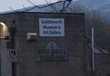
| Rearranging the world around Nominatim for fun and profit | Obviously me using traditional counties in the example above is a bit of a joke, but some people do seem to take it seriously. I was in this pub earlier today, and the landlady was very insistent that it was in Yorkshire not anywhere else. She’d agree with my joke server about the county: although it’s chosen the street name from the back door rather than the front. Further up the road the museum has this sign on the wall:
so it’s not just her! |
|
| Why is showing pedestrian crossings so complicated? | @kumakyoo You can see the code I’m using at https://github.com/SomeoneElseOSM/SomeoneElse-style/blob/master/shared_lua.lua#L7373 , but answering your questions:
Yes, I’ll show any of those as a
No, without infrastructure that wouldn’t.
Yes - that’s exactly the point I’ve made at various places in https://community.openstreetmap.org/t/separate-sidewalks-or-not-near-ealing/132613 and similar threads.
I believe that it makes sense to do that too, although there are edge cases where some other |
|
| Léarscáil 2025 | I bet you could search for “common Irish words” to identify some of them, for example this overpass query searches for “Bóthar” in |
|
| Léarscáil 2025 | What about things that have Irish names only, like this road? That just shows as this. I presume it’s in a Gaeltacht that far west in Galway, hence |
|
| Why is showing pedestrian crossings so complicated? | @cquest Interesting - is there a link to the tags used anywhere? |
|
| Rearranging the world around Nominatim for fun and profit | That’s surprisingly accurate :) |
|
| Politically motivated vandalism on OpenStreetMap | You need to be a little bit careful with that revert tool - it doesn’t work where there are multiple problem changesets (it actually makes things worse) and if the problem is still ongoing it can also make things worse (as it warns when you run it) due to the way that it queries the data. The Josm reverter is a good option that is interactive; it’ll help you untangle vandal and later good-faith changes. If you want to revert “everything not changed by a later mapper” then the perl revert scripts are a good option, but they require a bit of familiarity with the OSM API and scripts in general. If it looks too complicated just report it to the DWG :) |
|
| Politically motivated vandalism on OpenStreetMap |
Please email [email protected] with full details of who did what, when, and what the political context was. Without that we won’t even know about it. – Andy (from the DWG) |
|
| Analysing Swarm Intelligence: What's a Highway? |
It’d be interesting to know more about that - what did they actually say? |
|
| Towards Creating General Melchett's Map | This diary entry describes me making a series of changes to the I repeated that in 2022 - that “zoom2022” version supported Ubuntu 22.04, Ubuntu 24.04 and Debian 12. I’ve repeated it just now in 2025, and the resulting “zoom2025” version supports Debian 13. |
|
| The Côte de Blubberhouses and the Pacific Ocean |
Actually, no - based on local knowledge, Kex Gill is the major name here; Nun Ings is just some random name that someone has copied from an old map. Old OS maps are full of these, and unfortunately some people have copied them willy-nilly into OSM. Have a look at OS OpenMap StreetView for some of these old names (but note there that Kex Gill is the larger one) and at the newer OS OpenMap Local where Nun Ings does not appear at all. The name on the heath is just a made-up one; it only occurs in OSM. |
|
| Large and small trees | The vector version is live already - see https://map.atownsend.org.uk/vector/index.html#15.94/52.947792/-1.209111 for the area in the picture above. That map on that site covers UK and Ireland, but it’d be relatively easy for someone to create a similar map for a different area. The script used to create the map just takes Geofabrik areas as parameters (so here “europe britain-and-ireland”). You could use “europe france” as a parameter in the script to get a similar map for France, and as long as the machine generating the times didn’t run out of memory (there are ways of preventing that) it should “just work”. I’ve also made similar changes to the raster version of the same map, so “different sized trees” should appear there too. |
|
| Large and small trees |
Based on the usage that taginfo suggests I’m actually using four sizes - “<=10”, “>10”, “>20” and “>30”. There are enough of the larger two to justify them being there as well; but above 35 some values seem to become silly.
A couple of lines in the style try and do that. One is icon-allow-overlap (and also the way that the tree icon is drawn it’s designed to not look messy when drawn over others), and another is text-optional, which means that the icon will be shown even if there is no room for the text. |
|
| What if the OBDL, but explicitly inclusive and antifascist? | It’d be a licence, but not an open one. Json has such a clause and it isn’t considered an open licence. Who gets to decide what is “good” and what “not good”? You? Me? Santa? |
|
| mbtiles, mbtileserver, tileserver-gl |
That’s using raster tiles, do do that on you’re laptop I’d suggest installing WSL with either Debian or Ubuntu running there and then follow these instructions. If that isn’t an option but Docker is, try these. If you want vector tiles then I’d (as mentioned earlier) suggest Tilemaker under WSL and then Apache + mod_mbtiles. This was intended as a “soup to nuts” guide to doing that on Linux, but all but the “obtaining a server” part of that would likely also apply to WSL. You’ll then have to fiddle around with the Windows firewall (but then as a Windows developer you’re presumably used to doing that). |
|
| mbtiles, mbtileserver, tileserver-gl | Was there any reason why you chose Windows Server here (other than “it was what you had lying around”)? Windows versions of OSM tools always suffer because basically “no-one developing them uses Windows”. One thing that you might try include WSL - I’ve not tested that on your particular environment but I’d be surprised if it didn’t work, based on the things that have worked in the past. Serving vector tiles is basically just “serving a small portion of a big file”. In the past I’ve used Apache on Windows without problems, so one avenue to explore might be that with mod_mbtiles. I haven’t tried that on Windows, but it works fine on Debian Linux. |
|
| Roads without key: sidewalk | The check I use for displaying “is there a sidewalk on a road” on maps is https://github.com/SomeoneElseOSM/SomeoneElse-vector-extract/blob/main/resources/process-sve01.lua#L1790 . An example of a map that you can make with that is https://map.atownsend.org.uk/vector/index_svwd08.html#9.34/52.2054/-1.5605 - that only shows primary and secondary roads if you can walk on them. It wouldn’t be that difficult if you wanted to create a set of vector tiles in that schema for California. |
|
| About main keys and values | @kumakyoo yes - that mostly makes sense, and assuming that |