Nutchanon Wetchasit's Comments
| Changeset | When | Comment |
|---|---|---|
| 64439115 | about 7 years ago | เนื่องจากไม่มีคำตอบกับคำถามที่ถามไป, การแก้ไขไร้สาระนี้ถูกย้อนกลับแล้วในชุดการเปลี่ยนแปลง 64803664 <changeset/64803664>. Since there's no answer about the problem, this gibberish edit is now reverted in changeset/64803664 <changeset/64803664>. |
| 64438852 | about 7 years ago | เนื่องจากไม่มีคำตอบกับคำถามที่ถามไป, การแก้ไขไร้สาระนี้ถูกย้อนกลับแล้วในชุดการเปลี่ยนแปลง 64803664 <changeset/64803664>. Since there's no answer about the problem, this gibberish edit is now reverted in changeset/64803664 <changeset/64803664>. |
| 57203772 | about 7 years ago | Business owners are welcome to put their establishments on OpenStreetMap as long as they follow existing guidelines. However, changing an unrelated object to show your company name is not acceptable, and counts as vandalism <osm.wiki/Vandalism>. This edit is now reverted in changeset/64800230 <changeset/64800230>. |
| 64394106 | about 7 years ago | The issue of DHL counter I mentioned is now fixed in changeset/64787817 <changeset/64787817> with knowledge from ground survey. |
| 62688743 | about 7 years ago | I have corrected a part of this edit in front of Phradabos Foundation, via changeset/64625305 <changeset/64625305>. Reason: That is not a residential road, it is a driveway entrance to Phradabos Foundation's ground, through a gate. It should have been apparent from OSM data at the time of your edit, that the road you drew went through the wall into foundation's area. Why did you tag it with an incorrect `highway=residential` anyway? |
| 64394106 | about 7 years ago | With that aside, please do not upload this many POIs /across many countries/ together at once; especially when most of them are unnamed. - Unnamed POIs are difficult for others to use or verify.
At best, it could be thought that you are a cyclist who flown to several countries, without having local internet access; and you are basically a diligent mapper treading on Maps.ME's limitations <osm.wiki/Maps.me#Questionable_edits>. At wrost, it could be thought that you are camouflaging an impromptu import <osm.wiki/Import>. This is a severe policy violation, which could get your edits reverted, and your account blocked. So, please explain what you were trying to do. Otherwise, people are going to assume the wrost. |
| 64394106 | about 7 years ago | Regarding node #6054062003 <node/6054062003>, did you mean a DHL drop-off counter? Because it is actually located at the front of nearby Wash Hub laundromat, rather than in front of AreLomDee cafe next to it. Admittedly, the position accuracy of this one is decent enough, but the POI information is lacking; namely the brand of courier service. People are going to confuse it with Thailand Post, which is the only thing that we refer to as "post office" around here in Thailand. |
| 64512648 | about 7 years ago | Hello, it is Grab team again isn't it? Please note that contribution quality of Grab editing team is recently brought into question; several parts are proven by auditing and ground verification to be "uneducated", "misleading", or blatantly "false". While there are nothing which proves that this specific edit is bad in quality /yet/, the act of "creating large changeset that span multiple countries" alone can be seen as an attempt to *avoid auditing*. Doing this will not cast Grab editing team in positive light, and will give more reason for auditors to call for your changesets to be reverted /in whole/ if they happen to find any mistake. So, be sure to edit in small chunks that concentrates in small area (usually a single city block or district) and press Upload button to concludes the changeset, before switching to a different area. |
| 62333421 | about 7 years ago | 1. Which part of "Keep Straight Way Straight" that you don't understand? <osm.wiki/Good_practice#Keep_straight_ways_straight> Your editor (JOSM) is perfectly capable of maintaining straight road as repeatedly observed on-ground by me and other /surveying contributors/, yet you don't do it. It is not an isolated incident that I caught Grab-employed armchair mappers doing this. I now seriously doubt that your team actually read the documentation before "contributing" to OSM. 2. Why exactly you replace existing `building=commercial` tag on Thanapoom Tower with a nonfunctional `amenity=commercial`? This is nonsense, and is a *lousy* handling of other contributor's hard work. Again, it not an isolated incident either; I have caught Grab-employed armchair mapper changing whole temple into a road just few weeks before. ----- These carelessness are now reverted in changeset/64465129 and 64465551: - <changeset/64465129>
|
| 64438852 | about 7 years ago | การแก้ไขนี้มีลักษณะผิดปกติ, ดูรายละเอียดปัญหาที่การอภิปรายท้ายชุดการเปลี่ยนแปลง 64439115 <changeset/64439115> This changeset looks like an improper edit, see discussion on changeset/64439115 <changeset/64439115> for details on this problem. |
| 64439115 | about 7 years ago | ช่อง Changeset Comment ที่โปรแกรมขอให้กรอกก่อนบันทึกการแก้ไข จะมีไว้สำหรับให้คุณอธิบาย ว่าคุณได้ทำการแก้ไขอะไรไปบ้างในการบันทึกแต่ละครั้ง แต่เห็นคุณกรอกอะไรมาก็ไม่รู้ ดังนั้น ช่วยอธิบายสักหน่อยครับว่า เพราะอะไร คุณจึงได้วาดพื้นที่เปล่าๆ ขึ้นมาผืนหนึ่ง ซึ่งซ้อนทับกับส่วนประกอบข้างเคียง และยังมีบางส่วนแนบไปกับเส้นแบ่งเขต/แขวงครับ? (ซึ่งเป็นสิ่งที่ไม่ควรทำอย่างยิ่ง ยกเว้นคุณจะแน่ใจว่าสิ่งที่คุณวาดนั้น สิ้นสุดตรงแนวเขต/แขวงนั้นพอดี) และผมอยากจะถามเรื่องเดียวกัน ในชุดการเปลี่ยนแปลง 64438852 <changeset/64438852> ด้วยครับ The "Changeset Comment" field that your editor asked you to fill when saving your changes is for describing what exactly you have edited in that save point; yet I see you all wrote there is gibberish. So, please explain why you drawn an empty area that is overlapping with nearby features, and also shares nodes with district boundary? (The latter is a thing that you should *not* do, unless you are certain that the area you drawn is meant to end exactly at the district boundary) Same question for changeset/64438852 <changeset/64438852>. |
| 64438644 | about 7 years ago | ย้ำนิดหนึ่งครับ ว่า OpenStreetMap เป็นแผนที่จริง ที่คนจริงๆ ใช้, ฉะนั้นการบันทึกการแก้ไขทดลองลงบนแผนที่เป็นสิ่งที่ไม่ควรทำนะครับ, การเขียนมั่วๆ ลงในช่อง Changset Comment ก็เช่นกัน, อ่านเพิ่มเติมได้ที่: - <osm.wiki/Vandalism>
การแก้ไขนี้ถูกย้อนกลับแล้วในชุดการเปลี่ยนแปลง 64441662 <changeset/64441662>. Please note that OpenStreetMap is a real map that real people use. Please don't save test edits, and don't type gibberish as changeset comment. Read more at: - <osm.wiki/Vandalism>
This edit is now reverted via changeset/64441662 <changeset/64441662>. |
| 64412059 | about 7 years ago | I found it highly unlikely that there would be a natural spring in this part of the city; and I have travelled pass that point by bus few times-- I didn't see anything anything resembling a natural spring. Are you certain that it wasn't a human-made drinking fountain instead? This is much more common around here. - <amenity=drinking_water>
P.S. Tag `natural=spring` is supposed to mean a point where natural water from underground aquifer got emitted on the ground: <natural=spring>. |
| 64400626 | about 7 years ago | This is actually a duplicate POI of Casa Vimaya Hotel <way/234856661>. I have merged the newly-added name information into existing POI per changeset/64439917 <changeset/64439917>. |
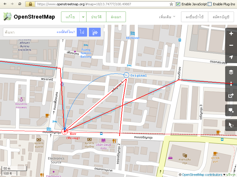
| 64348193 | about 7 years ago | Welcome to OpenStreetMap, Business owners are welcome to put their own establishments on the map, as long as they follow existing guidelines; and you seem to do fine on that part. However, the rest of of this edit mingled up parts of Charoen Krung 1 drive, Lot-Wat Ratchabophit canal, and MRT "blue" subway construction line together. This is wrong, and hazardous for satellite navigator users. Screenshot (red/blue emphases are mine):
Please be careful when you are editing. Make sure to use the Undo button when you realized that you moved parts that you didn't mean to. (Or exit without saving, if you need to start over) The Undo button in the editor you're using is the left-pointing U-turn icon on the inner top toolbar. This edit now reverted in changeset/64367031 <changeset/64367031>, save for the part that involves Villa Siam & Spa. |
| 64234859 | about 7 years ago | This changeset is now reverted in changeset/64263100 <changeset/64263100>. Please note that the information you added is not a stop name, but rather a list of bus numbers that stop there. This information however, belongs and already written in the `description` field, which is normally user-viewable in the application by tapping/hovering over the POI.
Appending bus list to the stop name just to make it display directly on the application you use is a practice of "Tagging for the Renderer" <osm.wiki/Tagging_for_the_renderer>. It is not a proper way to contribute to OpenStreetMap, since it broke other applications that make different uses of the same data. In this specific case, you are breaking OSM public transport map's ability to display a correct stop name. |
| 64059386 | about 7 years ago | On another note, you should also mark the "ตลาดอุดมสุข" building as a market too, so that people could find it when they search for a specific type of place. In your editor, select the building, expand the "All tags" section at the bottom of the sidebar, and click `[+]` button at the bottom of the tags table. Once the new row appears, fill "amenity" in the first cell, then "marketplace" in the second cell. After doing this and saving the edit, wait few minutes, and refresh the map; you would see a magenta-colored vendor booth icon above the building name- which indicates that the POI is a market. |
| 64059386 | about 7 years ago | The multilingual tagging issue aside, is "อุดมสุข" really officially written there as "Udom Sok" in English? Because to me, it seems that the correct one should be either "Udom Sook" (with double 'o') or "Udom Suk"; otherwise, the name would pronounce "อุดมศก" which carries a different meaning. |
| 64059386 | about 7 years ago | Hello there, welcome to OpenStreetMap. It's always nice to see new surveying contributors. Regarding your edits, please note that what you are doing is *not* a proper way to add multiple-language place name to a POI in OpenStreetMap [1]. Read more at: - <osm.wiki/Multilingual_names#Thailand>
In the iD editor you are using, the main `Name` field is for the local language (Thai), or the language that is written biggest on the sign of that place. To add a different language, click `[+]` button at the right of Name field, the "Multilingual name" box will appear, which you can select a new language ("English") and type in the new English name. For maximum compatibility to all OpenStreetMap-related software, you should also repeat what you just filled the main `Name` field in another "Multilingual name" box too, with appropriate language selection (e.g. "ไทย"). When done correctly, you should see something like this in your editor: | Name
Please fix your edits. P.S. If you are worrying about not seeing English name on the map, there is an alternate rendering of OpenStreetMap that displays both Thai and English name at once, here: <http://thaimap.osm-tools.org/> [1] The act of intentionally adding wrong data to make enhance a specific view of the map is called "Mapping for the Renderer" <osm.wiki/Tagging_for_the_renderer>. It is looked down upon; since it wrecks havoc in other applications that use OpenStreetMap data. In this specific case, the edit is breaking satellite navigators' ability to display POI in user's configured language. |
| 64078235 | about 7 years ago | Are you really sure that there is an open-to-public medical clinic within a military area? From my last visit, I still remember that the area is not open to public; and the Korean name you tagged the clinic "gonghang" ("airport") is not descriptive either, care to explain that? |