Nutchanon Wetchasit's Comments
| Changeset | When | Comment |
|---|---|---|
| 62715601 | about 7 years ago | This changeset has been partially reverted in the area Suankularb Wittayalai Alumni Association, via changeset/63498913 <changeset/63498913>. Reason: from on-field observation, driveway 621976781 obviously does not go through the back wall of the association; and the allegedly straight dangling northward segment of the driveway is simply inaccurate- it is not straight, and it do connect to the road- lining to the east side of parking area. |
| 63282866 | about 7 years ago | This is actually a duplicate POI of <way/178329973>, but I have added the Spanish name to it due to your edit. Thanks for participating. |
| 56538694 | about 7 years ago | Duly noted. For this intersection, the concern is now addressed in changeset/63312065 <changeset/63312065>. Anyway, does this also apply to node-based intersection, where intersection a node on the road itself? (Like this one: <node/373455280>) P.S. `highway=junction` is a thing I originally just picked from some existing (node-based) intersection on the map few years back when I didn't know how to map it yet. Some time later, I realized it wasn't documented on the Wiki, but I kept adding them anyway. |
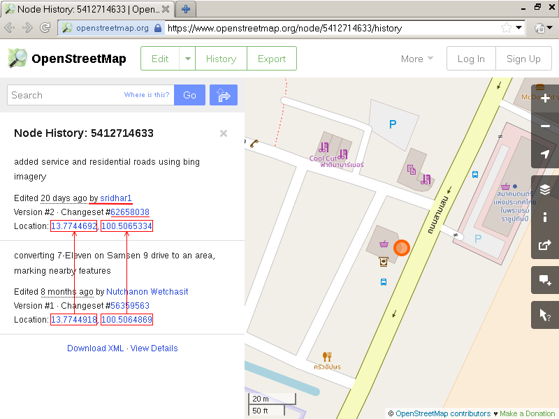
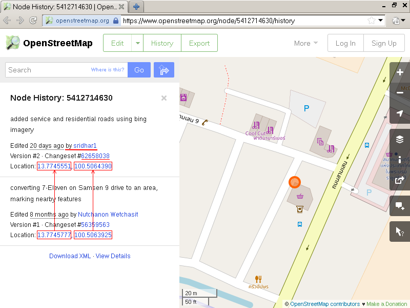
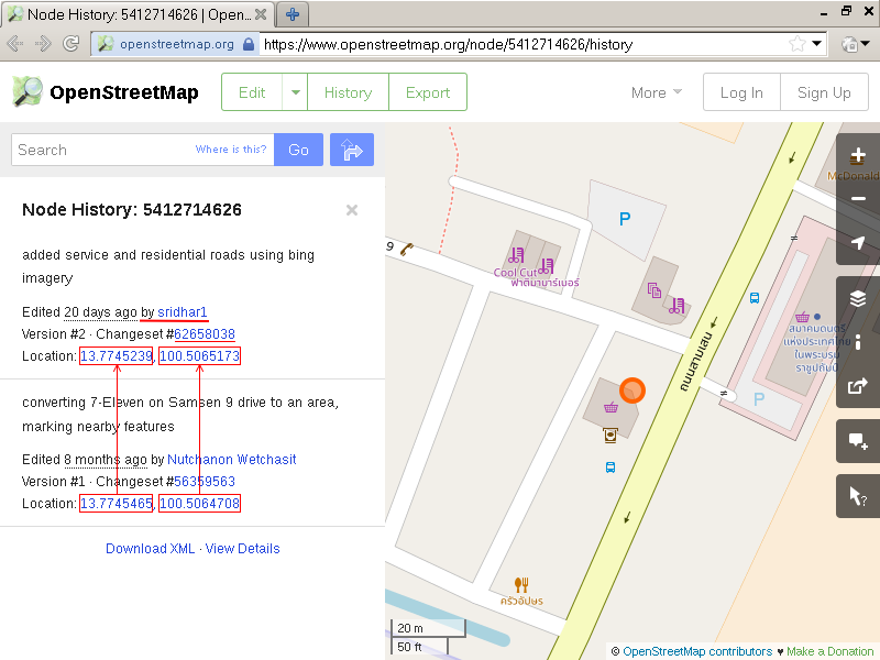
| 62658038 | about 7 years ago | > I tried checking the boundaries of 7 eleven Which tool you used for checking the history again? Since what you did was moving nodes (not adding or removing node to/from the way); checking history of the "way" won't do. You need to check history of each "node" that I pointed out in my last comment. I used the node history page on openstreetmap.org, and it is quite obvious that this edit (attributed to you) affected the nodes' position. Screenshots below, red emphases are mine: <https://u.cubeupload.com/xwindows/8wqgyN.png>
> and the nodes of POIs. This is correct, and the lack of said edits is a part of the problem I was speaking about in the second-to-last paragraph of my last comment. > Kindly take time to suggest how I go ahead and fix this issue No need, I have gone in and manually re-synchronized the local position of 7-Eleven relative to these POIs, then re-aligned global position of the group to the Bing 2018 imagery. This part is resolved in the changeset/63278653 <changeset/63278653>. There are more wrong things with this changeset in Samsen 9 drive alone; but they are not as critical as this one. So I will manually re-verify and correct each of them when I have time. Lastly, I would have to point out that on OSM, data from local survey are always preferred over data from imagery-based mapping. And don't realign objects solely because they are slightly shifted from the imagery (they always do). Local coherency are far more important. Also see <osm.wiki/Armchair_mapping#Disadvantages_and_controversy> again, especially point 4 in this case. |
| 62658038 | about 7 years ago | Let me repeat a part of my comment I said earlier: > another thing that's not making sense about this edit is how *it modified the outline of 7-Eleven* I said that "problem" about this part of the edit is the move of each node of /the store/. Affected nodes are listed below: <node/5412714633>
And from your statement: > For node links mentioned. icons representing map features, we didn't make any changes. That is exactly the problem. Those features are tied (literally) to the walls of 7-Eleven, despite that fact that they are outside. (If you visited the store personally, you would have known better) Moving the outline of 7-Eleven /without/ moving those POIs along with it broke local consistency, flipping outside things inside, shifting things at corners to the side wall. These are wrong. If you also moved the ATMs, scale, and the top up kiosk along with each corner of the store, preserving their relative position, I wouldn't have complained about this part of the edit. But you didn't, so here we are. |
| 62658038 | about 7 years ago | Regarding satellite-based mapping and data precedence, see: <osm.wiki/Armchair_mapping#Imagery_can_be_wrong> And also <osm.wiki/Armchair_mapping#Disadvantages_and_controversy>. |
| 62658038 | about 7 years ago | Anyway, another thing that's not making sense about this edit is how it modified the outline of 7-Eleven <way/561319303> next to Samsen 9 drive and the driveway, which badly interacted with small features around them: - 7-Eleven and the nearby Double A copy center <way/531706846> are supposed to be at an (more-or-less) equal distance from the midline of Samsen 9 drive.
And all of them are /outside/ (NOT inside) of 7-Eleven. These details are all added from in-person ground survey, and most of them were also re-verified yesterday that they were what I just described. Moving features to align them to (a newer) satellite image is not wrong in and unto itself. But in any case, always make sure to preserve local consistency in what you edit; otherwise there's no telling how many contributors' work that you have broken in the process. This is especially important when you didn't walk up there to verify them in-person. |
| 62658038 | about 7 years ago | Is a driveway connecting Musical Association of Thailand really supposed to be pointing to nowhere in the south?
Shouldn't it be directly connected to Samsen road, passing the gate? Note: I have re-verified this in-person yesterday: on the ground, this driveway connection is still looking the same as the day I originally authored changeset/52750735 <changeset/52750735>. |
| 62814440 | over 7 years ago | Does this actually present permanent bus station or an on-ground bus stop? Because I have walked pass this point about a week ago, and did not notice anything resembling a bus station; save for a disused BMTA bus stop, which is described so on the OSM. |
| 50873559 | over 7 years ago | I have been regularly walking pass this coordinate along the west side of Bowonniwet temple for several months now (at night time), and yet I could only spot the regular BMTA bus stop and a small 30 km/h speed limit sign around there. Is this intended for representing a ground-visible bus stop or terminus for Giant Ibis service? If it is, what shape or color should I look for, and does it appear only in a specific time of day? Thank you. P.S. Note that an actual Giant Ibis Transport office is mapped as a travel agent shop on Tanao road, ~60 m down south.
|
| 56374444 | almost 8 years ago | Hello there, welcome to OpenStreetMap. This edit of yours in the area between Samsen 11 and Samsen 13 drive looks like a humorous test on capability of OpenStreetMap editing: fictional roads lined to form a phrase "Quloro King of Cheat". Is it possible that you accidentally saved some test edits, Or that someone else have been using your account? I'd be glad if you could review and undo them. If you need help with that, just reply to this message. P.S. For what's allowed V.S not allowed on OpenStreetMap, see: osm.org/welcome |
| 39491721 | almost 8 years ago | Isn't the correct location of Wat Ratchanaddaram around 600m to the east? |