Nutchanon Wetchasit's Comments
| Changeset | When | Comment |
|---|---|---|
| 62333421 | about 7 years ago | 1. Which part of "Keep Straight Way Straight" that you don't understand? <osm.wiki/Good_practice#Keep_straight_ways_straight> Your editor (JOSM) is perfectly capable of maintaining straight road as repeatedly observed on-ground by me and other /surveying contributors/, yet you don't do it. It is not an isolated incident that I caught Grab-employed armchair mappers doing this. I now seriously doubt that your team actually read the documentation before "contributing" to OSM. 2. Why exactly you replace existing `building=commercial` tag on Thanapoom Tower with a nonfunctional `amenity=commercial`? This is nonsense, and is a *lousy* handling of other contributor's hard work. Again, it not an isolated incident either; I have caught Grab-employed armchair mapper changing whole temple into a road just few weeks before. ----- These carelessness are now reverted in changeset/64465129 and 64465551: - <changeset/64465129>
|
| 64438852 | about 7 years ago | การแก้ไขนี้มีลักษณะผิดปกติ, ดูรายละเอียดปัญหาที่การอภิปรายท้ายชุดการเปลี่ยนแปลง 64439115 <changeset/64439115> This changeset looks like an improper edit, see discussion on changeset/64439115 <changeset/64439115> for details on this problem. |
| 64439115 | about 7 years ago | ช่อง Changeset Comment ที่โปรแกรมขอให้กรอกก่อนบันทึกการแก้ไข จะมีไว้สำหรับให้คุณอธิบาย ว่าคุณได้ทำการแก้ไขอะไรไปบ้างในการบันทึกแต่ละครั้ง แต่เห็นคุณกรอกอะไรมาก็ไม่รู้ ดังนั้น ช่วยอธิบายสักหน่อยครับว่า เพราะอะไร คุณจึงได้วาดพื้นที่เปล่าๆ ขึ้นมาผืนหนึ่ง ซึ่งซ้อนทับกับส่วนประกอบข้างเคียง และยังมีบางส่วนแนบไปกับเส้นแบ่งเขต/แขวงครับ? (ซึ่งเป็นสิ่งที่ไม่ควรทำอย่างยิ่ง ยกเว้นคุณจะแน่ใจว่าสิ่งที่คุณวาดนั้น สิ้นสุดตรงแนวเขต/แขวงนั้นพอดี) และผมอยากจะถามเรื่องเดียวกัน ในชุดการเปลี่ยนแปลง 64438852 <changeset/64438852> ด้วยครับ The "Changeset Comment" field that your editor asked you to fill when saving your changes is for describing what exactly you have edited in that save point; yet I see you all wrote there is gibberish. So, please explain why you drawn an empty area that is overlapping with nearby features, and also shares nodes with district boundary? (The latter is a thing that you should *not* do, unless you are certain that the area you drawn is meant to end exactly at the district boundary) Same question for changeset/64438852 <changeset/64438852>. |
| 64438644 | about 7 years ago | ย้ำนิดหนึ่งครับ ว่า OpenStreetMap เป็นแผนที่จริง ที่คนจริงๆ ใช้, ฉะนั้นการบันทึกการแก้ไขทดลองลงบนแผนที่เป็นสิ่งที่ไม่ควรทำนะครับ, การเขียนมั่วๆ ลงในช่อง Changset Comment ก็เช่นกัน, อ่านเพิ่มเติมได้ที่: - <osm.wiki/Vandalism>
การแก้ไขนี้ถูกย้อนกลับแล้วในชุดการเปลี่ยนแปลง 64441662 <changeset/64441662>. Please note that OpenStreetMap is a real map that real people use. Please don't save test edits, and don't type gibberish as changeset comment. Read more at: - <osm.wiki/Vandalism>
This edit is now reverted via changeset/64441662 <changeset/64441662>. |
| 64412059 | about 7 years ago | I found it highly unlikely that there would be a natural spring in this part of the city; and I have travelled pass that point by bus few times-- I didn't see anything anything resembling a natural spring. Are you certain that it wasn't a human-made drinking fountain instead? This is much more common around here. - <amenity=drinking_water>
P.S. Tag `natural=spring` is supposed to mean a point where natural water from underground aquifer got emitted on the ground: <natural=spring>. |
| 64400626 | about 7 years ago | This is actually a duplicate POI of Casa Vimaya Hotel <way/234856661>. I have merged the newly-added name information into existing POI per changeset/64439917 <changeset/64439917>. |
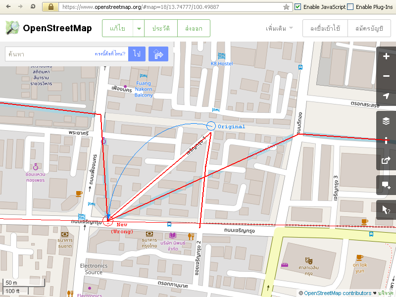
| 64348193 | about 7 years ago | Welcome to OpenStreetMap, Business owners are welcome to put their own establishments on the map, as long as they follow existing guidelines; and you seem to do fine on that part. However, the rest of of this edit mingled up parts of Charoen Krung 1 drive, Lot-Wat Ratchabophit canal, and MRT "blue" subway construction line together. This is wrong, and hazardous for satellite navigator users. Screenshot (red/blue emphases are mine):
Please be careful when you are editing. Make sure to use the Undo button when you realized that you moved parts that you didn't mean to. (Or exit without saving, if you need to start over) The Undo button in the editor you're using is the left-pointing U-turn icon on the inner top toolbar. This edit now reverted in changeset/64367031 <changeset/64367031>, save for the part that involves Villa Siam & Spa. |
| 64234859 | about 7 years ago | This changeset is now reverted in changeset/64263100 <changeset/64263100>. Please note that the information you added is not a stop name, but rather a list of bus numbers that stop there. This information however, belongs and already written in the `description` field, which is normally user-viewable in the application by tapping/hovering over the POI.
Appending bus list to the stop name just to make it display directly on the application you use is a practice of "Tagging for the Renderer" <osm.wiki/Tagging_for_the_renderer>. It is not a proper way to contribute to OpenStreetMap, since it broke other applications that make different uses of the same data. In this specific case, you are breaking OSM public transport map's ability to display a correct stop name. |
| 64059386 | about 7 years ago | On another note, you should also mark the "ตลาดอุดมสุข" building as a market too, so that people could find it when they search for a specific type of place. In your editor, select the building, expand the "All tags" section at the bottom of the sidebar, and click `[+]` button at the bottom of the tags table. Once the new row appears, fill "amenity" in the first cell, then "marketplace" in the second cell. After doing this and saving the edit, wait few minutes, and refresh the map; you would see a magenta-colored vendor booth icon above the building name- which indicates that the POI is a market. |
| 64059386 | about 7 years ago | The multilingual tagging issue aside, is "อุดมสุข" really officially written there as "Udom Sok" in English? Because to me, it seems that the correct one should be either "Udom Sook" (with double 'o') or "Udom Suk"; otherwise, the name would pronounce "อุดมศก" which carries a different meaning. |
| 64059386 | about 7 years ago | Hello there, welcome to OpenStreetMap. It's always nice to see new surveying contributors. Regarding your edits, please note that what you are doing is *not* a proper way to add multiple-language place name to a POI in OpenStreetMap [1]. Read more at: - <osm.wiki/Multilingual_names#Thailand>
In the iD editor you are using, the main `Name` field is for the local language (Thai), or the language that is written biggest on the sign of that place. To add a different language, click `[+]` button at the right of Name field, the "Multilingual name" box will appear, which you can select a new language ("English") and type in the new English name. For maximum compatibility to all OpenStreetMap-related software, you should also repeat what you just filled the main `Name` field in another "Multilingual name" box too, with appropriate language selection (e.g. "ไทย"). When done correctly, you should see something like this in your editor: | Name
Please fix your edits. P.S. If you are worrying about not seeing English name on the map, there is an alternate rendering of OpenStreetMap that displays both Thai and English name at once, here: <http://thaimap.osm-tools.org/> [1] The act of intentionally adding wrong data to make enhance a specific view of the map is called "Mapping for the Renderer" <osm.wiki/Tagging_for_the_renderer>. It is looked down upon; since it wrecks havoc in other applications that use OpenStreetMap data. In this specific case, the edit is breaking satellite navigators' ability to display POI in user's configured language. |
| 64078235 | about 7 years ago | Are you really sure that there is an open-to-public medical clinic within a military area? From my last visit, I still remember that the area is not open to public; and the Korean name you tagged the clinic "gonghang" ("airport") is not descriptive either, care to explain that? |
| 62658038 | about 7 years ago | This changeset is now partially reverted further in changeset/64133024 <changeset/64133024>, on the attribute of first internal branch of Samsen 9 drive. Reason: The branch way is heavily barricaded inside, and is only safe for walking by foot. Even riding a bicycle through it is a long shot; cars can't enter at all; re-verified by an on-foot ground survey. |
| 64133024 | about 7 years ago | Note that the partially-reverted changeset is actually 62658038 <changeset/62658038>, one in the commit message was mistyped. |
| 49055629 | about 7 years ago | This changeset is now reverted in changset 64087860. <changeset/64087860>. Reason: Wat Pho (a temple), and Wat Po TTM (a massage school) use different contact email. The email you tried to assign to the temple actually belongs to the massage school. References:
|
| 62781489 | about 7 years ago | This changeset is partially reverted in changeset/64065846 <changeset/64065846> around the east wall of Wat Bowonniwet school. Reason: That is not a residential road, it is a very short driveway leading to a school gate, and it doesn't normally allow motor vehicles to go inside. |
| 63819191 | about 7 years ago | ยินดีต้อนรับสู่ OpenStreetMap ครับ สำหรับการแก้ไขของคุณ ย้ำนิดว่าถ้าคุณเจอเซเว่นอยู่หน้า หรือในตึกธนาคารจริงๆ, การเำปลี่ยนชื่อตึกธนาคารให้เป็น "เซเว่น" นั้นไม่ถูกต้องนะครับ, ซึ่งผมได้ย้อนการแก้ไขของคุณออกไปแล้วในชุดการเปลี่ยนแปลง 64033987 <changeset/64033987> วิธีที่ถูกต้องคือ คุณจะต้องเพิ่ม POI/หมุด ตัวใหม่ ลงในพื้นที่ของธนาคาร โดยตั้งชนิดหมุดตัวนั้นให้เป็นร้านสะดวกซื้อ แล้วจึงใส่ชื่อหมุดเป็น "7-Eleven" ตามป้ายที่เขียนไว้หน้าร้านครับ พยายามใหม่นะครับ ป.ล. แต่ถ้าคุณลองแก้เล่นดูเฉยๆ โดยไม่ได้มีเซเว่นจริงๆ ก็อย่าลืมนะครับว่า OpenStreetMap เป็นแผนที่ที่แสดงโลกของจริง และคนจริงๆ ก็ใช้, ฉะนั้นถ้าแค่ทดสอบ อย่ากดบันทึกนะครับ Welcome to OpenStreetMap, For your edit: please note that when you found a 7-Eleven inside of in front of the bank building, changing bank's building name to "7-Eleven" is a wrong thing to do. I have now reverted your edit via changeset/64033987 <changeset/64033987>. The right thing however, is to create a new POI node in the area of bank building; with its type set to "Convenience store", and its name set to "7-Eleven"- per what's written in front of the store. Keep calm, and try again. P.S. If you are just testing out editing without actually found the 7-Eleven store there; please keep in mind that OpenStreetMap is a map about real things, and real people use it. When just testing, exit without saving. |
| 56024175 | about 7 years ago | Are you sure that this fast food restaurant is really located right there in the _middle of intersection_, and not because of an GPS error? Because this sort of occurence is /highly unlikely/ with this kind of intersection, even when assuming the POI was being a small food stand. |
| 63925142 | about 7 years ago | ยินดีต้อนรับสู่ OpenStreetMap ก่อนอื่นต้องเน้นนิดหนึ่งว่า OpenStreetMap เป็นแผนที่จริง ที่คนจริงใช้, ฉะนั้น ถ้าลองแก้สนุกๆ ทดสอบดูแล้ว ให้ปิดโดย *ไม่บันทึก* ก่อนที่จะเริ่มทำของจริงนะครับ ตอนนี้ผมได้ย้อนการแก้ไขทดสอบของคุณออกไปให้แล้ว ด้วยชุดการเปลี่ยนแปลง 63955094 <changeset/63955094>. ทีนี้ออกไปทำของจริงกันได้เลย, แต่ถ้าสงสัยอะไรก็มาว่ากันต่อได้ หรือไม่ก็ไปอ่านดูที่วิกิ <osm.wiki/> ขอให้สนุกกับการเป็นช่างแผนที่สมัครเล่นครับ Welcome to OpenStreetMap. Before you continue, I must stress that OpenStreetMap is a real map that real people use. When you finished testing out an editor, exit *without saving*; before starting again for editing the real thing. This test edit is now reverted as of changeset/63955094 <changeset/63955094>. Now, go map the real thing. If you have questions, just ask, or consult the Wiki <osm.wiki/>. Have fun being an amateur cartographer. |
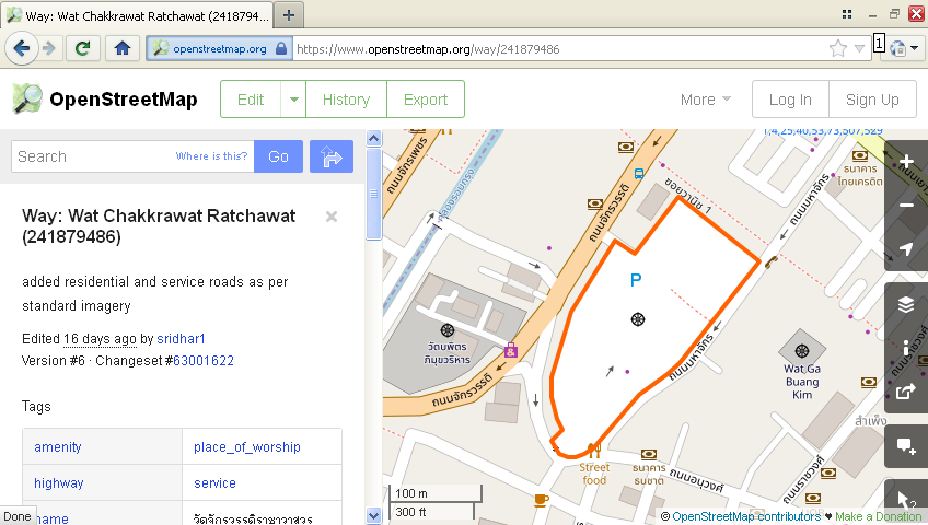
| 63001622 | about 7 years ago | This changeset resulted in a _nonsensical_ rendering of Chakkrawat Ratchawat temple: the temple as whole is *NOT* supposed to be a road. The temple: <way/241879486>
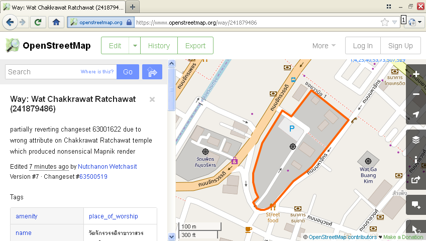
This part of the change (an addition of `highway` attribute to the temple area) is now reverted in changeset/63500519 <changeset/63500519>. Screenshot (after revert): <https://u.cubeupload.com/xwindows/melrkn.png> Anyway, when you see a road on imagery surrounding a feature, DO NOT mark the feature as road- because it's not. Create a new roadway surrounding outside (or lining inside) the feature instead. And before you get any funny ideas, DO NOT just create a new "way" that simply go through the exact same "nodes" as the feature's wall either: doing this meant the road was constructed at the top that wall- a really rare occurence; which is very unlikely to apply in this case. In any case, don't neglect to verify the result of your edit on the main Mapnik view on <osm.org/> after closing your changeset (wait several minutes after saving, then press Ctrl+F5 on your browser while browsing on the area). Otherwise there will be a large chance of letting this kind of "gotchas" slip, burdening other /unpaid/ OSM contributors to fix your mistake. P.S. I've looked at the Bing 2018, DigtalGlobe Premium, and DigitalGlobe standard imagery on the area; the temple outline by itself does not look like a road anyway. So, why did you make this attribute edit in the first place? |