OpenStreetMap logo OpenStreetMap

Users' Diaries

Recent diary entries

Você está cansado de mapear apenas vias e edificações?

Venha conosco e vamos mapear o mundo juntos 🌎


Tenho o prazer de informar sobre a iniciativa que coordenei e que foi promovida pela minha empresa, IVIDES DATA®. Organizamos três reuniões online em setembro e outubro de 2025, nas quais ensinei sobre mapeamento com os editores iD e JOSM, desde recursos simples, como caminhos, até recursos complexos, como multipolígonos, além de validação com JOSM, OSMCha, Osmosis e OSM Inspector.

Com essa iniciativa, pudemos notar que as pessoas não estão muito familiarizadas com a edição de algo diferente de edificações e vias, o que faz parte de inúmeras campanhas promovidas por outras empresas privadas e ONGs internacionais que atuam no Brasil, onde moro. Para entender esse movimento no meu país, você pode ler o capítulo que escrevi no meu último livro.

Espero sinceramente que estas sessões de formação possam ajudar mais pessoas a compreender o poder por trás do projeto OpenStreetMap… Sim! É um projeto global com 21 anos e não apenas uma plataforma. Por favor, não minimizem o OSM, reduzindo-o ao seu site.

E gostaria de enfatizar que este material não é útil apenas para atividades de ensino, mas também pode ser um recurso útil para você aplicar em seus projetos e inspirá-lo a criar mais e melhores projetos!


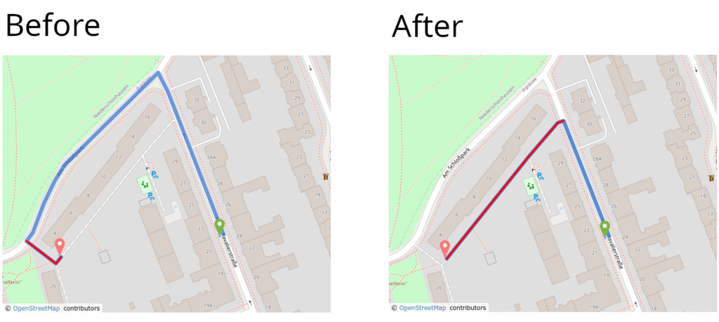
Oficina #1 - Mapeando caminhos no OpenStreetMap com o editor iD


Nesta sessão, mostro como mapear outros tipos de vias, como cursos de água ou calçadas, com o iD, o editor mais fácil para OSM. E algumas das regras de ouro para este tipo de mapeamento e conteúdo conceitual para prepará-lo para as outras duas oficinas.

See full entry

Posted by Odological on 19 October 2025 in English.

I’m writing my first OSM Diary entry in hopes that some local Thunder Bay, ON or Northwestern Ontario mapper(s) will find me here. When I look at the dashboard, I don’t see any local mappers that have edited during the past several years, and no local mappers that have made a single diary entry. If you do stumble across this post, I want you to know that you are not alone trying to improve OSM in Thunder Bay.

As the title suggests this post was precipitated by achieving one of the New Year’s resolutions I made late last December, 2024. At the time I noted that I had only made 42 edits over the ~13 years I had been signed up with OSM and tasked myself with at least doubling this. As of today, 2025-10-19, I have made exactly 84 edits that have included over 1500 individual changes to the map this past year so far. This is small potatoes compared to people that are really active editors, but I just recently started ramping up my edits in the past several weeks as I have gained confidence mapping sidewalks and crossings following a protocol that is designed to be helpful for network modelling for diverse map users.

I have some ideas to get more people contributing to OSM in Northwestern Ontario, including some mapathons and other social events. I hope to meet you soon, in-person or on the interwebs.

Location: Northwood, Thunder Bay, Thunder Bay District, Northwestern Ontario, Ontario, Canada
Posted by matteobott on 19 October 2025 in Italian (Italiano).

Il lavoro consiste nel raccogliere, verificare e inserire dati geografici della città di Abbiategrasso, in provincia di Milano, in modo che chiunque possa consultarli e riutilizzarli liberamente.

Attraverso gli editor OSM, JOSM e rapID, sto tracciando edifici, strade, spazi pubblici e punti di interesse (come scuole, negozi, monumenti e servizi). Per ogni elemento aggiungo informazioni utili — come nomi, numeri civici, funzioni o categorie — seguendo le linee guida del progetto e con rispetto alla precisione e all’attendibilità del dato geografico.

Dove possibile, integro i dati da osservazioni sul campo, foto o tracce GPS, per verificare ciò che non è visibile dalle immagini satellitari. L’obiettivo è creare una mappa completa, accurata e aggiornata di Abbiategrasso, utile per cittadini, turisti, amministrazioni e sviluppatori di applicazioni basate su dati geografici liberi.

Questo lavoro contribuisce a rendere Abbiategrasso più visibile e accessibile digitalmente, inserendola in una rete globale di conoscenza geografica condivisa e partecipativa.

Location: Cascina Poscallo, Abbiategrasso, Milano, Lombardia, 20081, Italia

Bali, Indonesia’s “Island of the Gods,” is celebrated for its natural beauty and spiritual heritage, yet faces a complex array of disaster risks shaped by tectonic activity, climate variability, and human development. Located on the Pacific Ring of Fire, the island is prone to earthquakes, volcanic eruptions, floods, landslides, and tsunamis. Mount Agung, a sacred stratovolcano in Karangasem, exemplifies this duality revered by Balinese Hindus and feared for its deadly eruptions, including the catastrophic event in 1963 and its reawakening in 2017. In Karangasem, disaster risk reduction has progressed through a fusion of local leadership and geospatial innovation. Participatory mapping, drone surveys, and open data platforms now support early warning systems and contingency planning. Community-based programs such as Desa Tangguh Bencana and the Centre of Excellence initiative empower residents to map hazards, design evacuation routes, and conduct preparedness drills.

See full entry

Bonjour,

J’écris cet article afin d’indiquer les noms de rues écorchés par la Maire de Poitiers et ses adjoints (ainsi que ses prédécesseurs) avec liens sur Google Maps en mode Satellite :

  • Faubourg de la Cueille-Mirebalaise (en rue du Faubourg de la Cueille Mirebalaise

https://www.google.com/maps/place/1+Fbg+de+la+Cueille+Mirebalaise,+86000+Poitiers/@46.5938404,0.3349893,3a,15y,229.95h,89.6t/data=!3m7!1e1!3m5!1sRNXNsoevT7AgRq0CjrsJ3g!2e0!6shttps:%2F%2Fstreetviewpixels-pa.googleapis.com%2Fv1%2Fthumbnail%3Fcb_client%3Dmaps_sv.tactile%26w%3D900%26h%3D600%26pitch%3D0.40260647462223176%26panoid%3DRNXNsoevT7AgRq0CjrsJ3g%26yaw%3D229.94937793376542!7i16384!8i8192!4m6!3m5!1s0x47fdbde039c18e43:0x1c445fe16d367cbd!8m2!3d46.5938387!4d0.3348054!16s%2Fg%2F11nnkmll20?authuser=0&entry=ttu&g_ep=EgoyMDI1MTAxNS4wIKXMDSoASAFQAw%3D%3D

https://www.google.com/maps/@46.5974212,0.3270056,3a,20.4y,50.75h,87.4t/data=!3m7!1e1!3m5!1s0pfWboUxBuAEiEmKGMopug!2e0!6shttps:%2F%2Fstreetviewpixels-pa.googleapis.com%2Fv1%2Fthumbnail%3Fcb_client%3Dmaps_sv.tactile%26w%3D900%26h%3D600%26pitch%3D2.603578475874528%26panoid%3D0pfWboUxBuAEiEmKGMopug%26yaw%3D50.75451961715702!7i16384!8i8192?authuser=0&entry=ttu&g_ep=EgoyMDI1MTAxNS4wIKXMDSoASAFQAw%3D%3D

https://www.google.com/maps/place/1+Fbg+de+la+Cueille+Mirebalaise,+86000+Poitiers/@46.5938404,0.3349893,3a,15y,351.73h,92.42t/data=!3m7!1e1!3m5!1sRNXNsoevT7AgRq0CjrsJ3g!2e0!6shttps:%2F%2Fstreetviewpixels-pa.googleapis.com%2Fv1%2Fthumbnail%3Fcb_client%3Dmaps_sv.tactile%26w%3D900%26h%3D600%26pitch%3D-2.4197143927485456%26panoid%3DRNXNsoevT7AgRq0CjrsJ3g%26yaw%3D351.73495820409886!7i16384!8i8192!4m6!3m5!1s0x47fdbde039c18e43:0x1c445fe16d367cbd!8m2!3d46.5938387!4d0.3348054!16s%2Fg%2F11nnkmll20?authuser=0&entry=ttu&g_ep=EgoyMDI1MTAxNS4wIKXMDSoASAFQAw%3D%3D

  • avenue Lepeletier (écrit avenue Le Pelletier)

See full entry

Posted by marazzer on 17 October 2025 in English.

I have gotten into mapping farmland and rural landuse this week.

It is very fun, and I feel productive. I can color up a village that feels boring without it.

Here is a link for the map, it is the village centre of the village of Kombornia, all of the landuse around has been mostly made by me.

Location: Od Wygody Zakręgi, Kombornia, gmina Korczyna, Krosno County, Subcarpathian Voivodeship, 38-422, Poland

Introducing PowerShell.Map v1.0.0

I’m excited to share PowerShell.Map - a new module that brings interactive OpenStreetMap visualization to the PowerShell command line!

What it does

PowerShell.Map opens interactive maps in your browser directly from PowerShell commands:

# Display multiple locations
Show-OpenStreetMap Paris, London, Rome

# Show routes with turn-by-turn directions
Show-OpenStreetMapRoute -From Tokyo -To Osaka

# Create animated tours
Start-OpenStreetMapTour Tokyo, Kyoto, Osaka -Duration 2

Use cases

PowerShell.Map brings OSM’s powerful features to the command line:

  • Zero setup: Interactive maps with a single command - no web development needed
  • Scriptable: Automate map generation from CSV, databases, or any data source
  • AI-powered: Let Claude Desktop create maps via natural language

Technical stack

This project is built entirely on OpenStreetMap’s ecosystem:

  • Leaflet.js for interactive map display
  • OSM tiles for base maps
  • Nominatim for geocoding
  • OSRM for routing and directions
  • Built-in HTTP server for seamless browser integration

Thank you to the OSM community for providing these excellent services!

AI integration

PowerShell.Map integrates with Claude Desktop via PowerShell.MCP, enabling natural language map visualization.

First, tell Claude to set up the module:

“Show me some fun map demos using the PowerShell.Map module”

Then simply ask for what you want:

  • “Show me a tour of famous temples in Kyoto”
  • “Create a route from Tokyo Tower to Senso-ji Temple”
  • “Show me a walking tour of cafes in Paris”
  • “Plan a hot spring tour across Japan with routes between locations”

Claude translates these requests into PowerShell.Map commands and displays the interactive map instantly.

Links:

Installation

See full entry

Are you tired of mapping only highways and buildings?

Come with us and let’s map the World together 🌎


I am very happy to tell you about the initiative that was coordinated by me and promoted by my company, IVIDES DATA™. We organized three online meetings in September and October 2025, where I taught about mapping with the iD and the JOSM editors, from simple features, such as paths, to complex features, such as multipolygons, and also validation with JOSM, OSMCha, Osmosis and OSM Inspector.

With this initiative, we could note that people are not very familiar with editing something different of buildings and highways, which is part of countless campaigns promoted by other private companies and international NGOs operating in Brazil, where I live. To understand this movement in my country, you can read the chapter that I wrote in my last book.

I really hope these training sessions can help more people to understand the power behind the OpenStreetMap project… Yes! It is a 21 years old global project and not only a platform. Please, do not miniaturize the OSM, reducing it to its website.

And I would like to emphasize that this material is not only useful for teaching activities, but can be also a useful resource for you to apply to your projects and to inspire you to create more and better projects!


Training Session #1 - Mapping ways in OpenStreetMap with iD editor


At this session, I show how to map other type of ways, like waterways or sidewalks, with iD, the easiest editor for OSM. And some of the golden mapping rules for this kind of mapping and conceptual content to prepare you to the other two lessons.

See full entry

A LATAM community with new energy, and the SotMs have a lot to do with it

I am very happy to observe and participate in a trend that, since 2024 in Belém (Brazil), has been moving forward: a very positive streak in the OSM Latam community —the community where I am most active— around people who have managed to mobilize more people and remain united and cohesive up to the next regional State of the Map, which has already been chosen together with our Mexican community to take place in the historic center of Mexico City, in the wonderful historical building of the Antiguo Colegio de San Ildefonso.
A very good alliance and a very good omen with the Instituto de Geografía of UNAM, a historical debt for the OSM Mexico community.

I have always been convinced that the regional level in Latam has the greatest potential to share its impactful experiences and to strengthen deeper dynamics, as seen at different times in its history. And we are precisely in one of those moments.
This same community is the one that gave birth to another of my dearest communities, Geochicas. For me, it is a nursery where important things emerge.

So it really gives me great joy to see us growing around the organization of these State of the Maps, and to see how it has happened since Belém, now in Medellín, and that it also looks promising for Mexico — a true regional collaboration, and not just a responsibility assumed by the host country.

It’s also been some time since this community used to have frequent tensions, leading to frustration and resignations caused by exclusionary visions. Curiously, a time of calm and novelty has arrived, and it feels VERY good.

For me, the State of the Map Latam Medellín has been the reaffirmation of something that could already be felt for about a year or a little more.

SotM Medellín

See full entry

Location: Campo Alegre, Comuna 12 - La América, Medellín, Valle de Aburrá, Antioquia, RAP del Agua y la Montaña, 050033, Colombia

Una comunidad LATAM con nueva energía, y los SotM tienen mucho que ver

Estoy muy feliz de observar y participar en una tendencia que, desde 2024 en Belén (Brasil), se ha movido: una racha muy positiva de la comunidad OSM Latam —la comunidad donde más activa soy— en torno a personas que han sabido movilizar a más personas y seguir siendo unidas y cohesionadas hasta el próximo State of the Map regional, que ya ha sido elegido con nuestra comunidad mexicana para suceder en el centro histórico de la Ciudad de México, en el maravilloso edificio histórico del Antiguo Colegio de San Ildefonso.
Una alianza muy buena y un muy buen augurio con el Instituto de Geografía de la UNAM, una deuda histórica para la comunidad OSM México.

Siempre he estado convencida de que el nivel regional en Latam es el que más potencial tiene para compartir sus experiencias de impacto y impulsar dinámicas de fondo, como se ha visto en diferentes momentos de su historia. Y estamos en uno precisamente. Esta misma comunidad es la que ha dado nacimiento a otra de mis comunidades queridas, Geochicas. Para mí, es un vivero donde surgen cosas importantes.

Entonces, me genera realmente un gran agrado vernos crecer en torno a la organización de estos State of the Map, y ver cómo ha sucedido desde Belén, ahora en Medellín, y también pinta para México una real colaboración regional, y no una responsabilidad esencialmente asumida por el país anfitrión.

Ha pasado también un tiempo desde que esta comunidad tenía tensiones frecuentes, desembocando en frustraciones y renuncias por visiones excluyentes. Curiosamente ha llegado un tiempo de calma y de novedad, y se siente MUY bien.

Para mí, el State of the Map Latam Medellín ha sido la reafirmación de algo que se podía sentir desde hace un año o un poquito más.

SotM Medellín

See full entry

Location: Urbanización San Michel, 215, Comuna 13 - San Javier, Perímetro Urbano Medellín, Medellín, Valle de Aburrá, Antioquia, RAP del Agua y la Montaña, Colombia

Με τη βοήθεια της ιστοσελίδας του Σκλαβενίτη, έκανα ένα πέρασμα από τα καταστήματα σε όλη την Ελλάδα εκτός της περιφέρειας Αττικής που ούτως ή άλλως είναι σε πολύ καλό επίπεδο χαρτογράφησης. Ήθελα να βρίσκω τη διεύθυνση σε κάθε κατάστημα που έχει συνήθως και σταθμό φόρτισης για να την περνάω και σε κάθε σταθμό.

Σημείωση, ότι υπάρχουν και επιπλέον καταστήματα “Franchise Σκλαβενίτης” που δεν εμφανίζονται στην ιστοσελίδα του Σκλαβενίτη. Σε αυτά κρατάμε το brand αλλά έχω δώσει τη σωστή ονομασία που είναι εμφανής έτσι και αλλιώς σε κάθε κατάστημα Franchise.

Σύνδεσμοι

I am so excited to have Unique Mappers RSU chapter virtual event taking off today for the next 3 days. I am also excited to have Favour and Adanna anchoring this event as part fo their internship program task

Prof .P Ede of Geography Dept and Dr . Erefama of Geology was in attendance along with so many others .

Cheers to Unique Mappers Nigeria

Posted by Mikhail Kuzin on 13 October 2025 in English. Last updated on 14 October 2025.

Good day, friends!

We’re excited to announce the official launch of our OSM editor.

OSMPIE — OSM Perfect Intersection Editor

This specialized editor helps users efficiently add and correct road and intersection data.

hero-img5

The application enables you to:

  • Visualize roads and intersections based on the OSM semantic model.
  • Verify tags and road structures — inaccuracies and inconsistencies are instantly visible.
  • Share links to your edits for discussion and review before uploading data to OSM.
  • Export render data to GeoJSON.

The OSM semantic model is almost perfect but lacks a few elements for creating truly flawless intersections. OSMPIE provides several specific tags and extensions for existing ones. Their syntax and application are detailed in the documentation, which includes compelling examples.

Explore the key features:

See full entry