Auf der Tholeyer Gemarkung befinden sich heute noch circa 15 historische Wegekreuze (http://overpass-turbo.eu/s/1Po6). Diese stehen an Straßen und gut begehbaren Wegen, so dass sie auch zu Fuß gut erreichbar sind. Bisher waren nur 6 davon in OSM grunderfasst. Die restlichen 9 habe ich nun erstmal kartiert, die übrigen ergänzt und aktualisiert. Weitere Infos finden sie unter
http://www.besse.de/buecher/2024_Tholeyer_Wegekreuz-Tour.pdf
Das nachstehende Foto zeigt eine kleine Auswahl an Wegekreuzen aus Tholey am Schaumbergsteig:

Users' Diaries
Recent diary entries

Together with LibreLabs Albania and OpenStreetMap Albania, we decided to celebrate the 20th birthday with an Online Mapping Party. We decided to “Map the Balkans”, so we extracted 55 villages from 11 countries, and we will come together on the 10th at 19:00 to celebrate and map.
Blog post from LibreLabs - https://librelabs.cc/blog/openstreetmap-online-mapping-party/
OSMcal - https://osmcal.org/event/3041/
Wiki - osm.wiki/OpenStreetMap_20th_Anniversary_Birthday_party
Anybody who wishes to join is more than welcome!
Happy 20th birthday, OpenStreetMap!
Update on the progress for the last 5 days of mapping.
I have mapped the villages:
A special thank you again to perenniallylate for mapping Ujëmirë
“#100villagesin100days”
Posted by TBesse on 6 August 2024 in German (Deutsch).
Last updated on 7 August 2024.
Im Jahr 1739 wurden die Rittenhofer und Herchenbacher Gemeindewälder durch den Nassau Saarbrücker Feldmesser Hahn vermessen und ausgesteint, um die Wälder von den Felder abzutrennen (separieren). Auf diesen Waldsteinen war auf der Vorderseite die laufende Nummer und auf der Rückseite die Jahreszahl der Steinsetzung 1739 angebracht. Auf der Seite zum Feldland wurde der Marker „F“ und auf der Waldseite der Buchstabe „W“ für Wald eingemeißelt. Von den damals gesetzten 26 Steinen sind bisher nur sechs Exemplare gefunden worden; 5 davon konnte ich nun in OSM erstmals kartieren (http://overpass-turbo.eu/s/1Poy). Die vom Feldmesser Hahn angefertigten Karten zu dieser historischen Waldvermessung sind in folgendem Beitrag enthalten: http://www.besse.de/buecher/1739_Rittenhofen_Herchenbacher_Waelder.pdf
So sehen die vier Seiten dieser recht alten Waldsteine im Köllertal aus:

Our OpenMapping iniative for #Wayaland Last few days Our #opendatakerala team with #OSMKerala OpenStreetMap working with officials and National Disaster Response Force for the mapping needs in their field needs. Just Noticed a news came few days back. Thanks The New Indian Express
Started a discussion on difference between place_of_worship=mosque and place_of_worship=musalla
How is it going and what am I up to now?
Introduction
I know I put in a entry in the diary not to long ago but I want to let you know what I am up to now. I am putting the finishing touches on my eruv map with I hope looks good. I am getting help with it and thank you to the gentleman that is helping.
What’s next?
-
I am currently spending a lot of time on StreetComplete and MapComplete. They are really good for me. I am helping my local community by validating roads, building, hours of operation, what sidewalks are made of, if the road is asphalt or what ever. I am really having a lot of fun doing it and its a good feeling that hey I have no clue if this helps anyone but it helps knowing I am helping.
-
I am also interested in adding things to OSM. I am fascinated by what I have seen from others. It would be good to start with one thing like roads, building, etc. Still learning the types of things OSM maps. Then build from that point once I get relatively comfortable with whatever this is.
-
Eventually I would love to get down to one or two things and really get good mapping those. I do not know the full capabilities of OSM, its a lot I am sure. Just hope I can be more specific and get very comfortable doing that one or things.
-
I am super interested in sustainability and resiliency. I would love to start to map and get involved in this area at some point. I also want to find out if OSM has something like Esri Story Maps. I want to see if I can tell stories of people for resilience. Cultures and peoples have has a long history of successful resiliency initiatives. That is the Story Map type thing came from.
Conclusion
I am super happy I found OSM and you all are very kind and generous and always happy to answer question. Just want to say thank you!
OSM is a tremendously powerful tool that I would love to see how it is used day-to-day by different organizations.
Till next time!
Posted by TBesse on 4 August 2024 in German (Deutsch).
Last updated on 7 August 2024.
In der 2. Hälfte des 18. Jahrhundert wurden um den früheren zur lothringischen Herrschaft Kriechingen (Créange) und seit 1767 zur Grafschaft Saarbrücken gehörenden Ort Püttlingen die Banngrenzen zu den Nachbarn neu ausgesteint. Insgesamt wurden mehr als 90 Steine gesetzt, von denen heute noch 57 erhalten geblieben sind. Nachdem der 1783er Grenzzug zu Völklingen hin schon vor ca. 8 Jahren erstmals kartiert wurde, konnte nun eine Aktualisierung vorgenommen werden (http://overpass-turbo.eu/s/1PoE). Dabei haben wir auch unsere Püttlinger Grenzstein-Tour überarbeitet, die Sie nun unter https://www.besse.de/buecher/2024_Puettlinger_Grenzstein-Tour.pdf finden. Leider musste die letztjährige Wanderung um den Dickenberg entlang des 1783er Grenzzuges wegen Sturmwarnung abgesagt werden.
Die nachstehende Karte zeigt die Wanderkarte entlang dieser Grenze zwischen Völklingen und Püttlingen von 1783.

Posted by TBesse on 4 August 2024 in German (Deutsch).
Last updated on 7 August 2024.
In der 2. Hälfte des 18. Jahrhundert wurden in der Grafschaft Saarbrücken des damaligen Fürstentums Nassau-Saarbrücken viele Banngrenzen zwischen den in der Grafschaft Saarbrücken liegenden Orten mit hohen stattlichen Bannsteinen ausgesteint. Nachdem das Kloster Wadgassen am Frankreich eingetauscht wurde, wurde im Jahr 1771 die Völklingen/Bouser Grenze über die Röchlinghöhe mit 28 Grenzsteinen versehen (http://overpass-turbo.eu/s/1PoH). Hiervon hat Fahrradler bereits in den letzten 10 Jahren eine Vielzahl der Grenzsteine kartiert. Nun konnte die letzten noch fehlenden Steine ergänzt werden. Die ganze Völklinger Grenzstein-Tour finden Sie unter https://www.besse.de/buecher/2024_Voelklinger_Grenzstein-Tour.pdf
Hier die Fotos der 4 Seiten des schönsten erhaltenen Grenzsteins um Völklingen

Posted by GPSPERU on 4 August 2024 in Spanish (Español).
Last updated on 20 March 2025.

Es necesario un nuevo formato de mapa para poder instalar uno que sea CITY NAVEGADOR para los gps de conducción como el Garmin Zumo XT y otros; ya que este gps no es igual que los gps de senderismo. Los mapas Base, dem, y topograficos si se ve perfecto en gps de senderismo como Etrex, Montana 680,700. Pero en los Gps de conduccion como el Zumo XT y ahora el nuevo Zumo XT2, no ayuda en nada los mapas de osm especialmente para PERÚ, las calles aparecen entrecortadas o lugares sin calles, es asi que el gps da error con los mapas porque no encuentra las calles en ciudades, recomiendo que deben crear mapas actualizados para gps de conduccion que se pueden usar siempre y cuando hayan caminos bien trazadops, le recomiendo a los desarrolladores hacer nuevo mapa RUTEABLE para instalación en gps de conducción.
Posted by TBesse on 3 August 2024 in German (Deutsch).
Last updated on 7 August 2024.
Im 18. Jahrhundert wurden um Falscheid zu den Nachbarn Reisweiler, Labach und Knorscheid mehr als 40 Hoheits- und Banngrenzsteine gesetzt. Davon waren bisher nur wenige Steine beispielsweise im Golocher Wald in OSM erfasst. Aufgrund eigener Forschungen aus den Jahren 2021/22 konnte ich heute einen Großteil dieser stattlichen, mit zahlreichen Markern versehenen historischen Banngrenzsteine um Falscheid in OSM kartieren (http://overpass-turbo.eu/s/1PoF). Falscheid gehörte bis 1767 teilweise zu der lothringischen Herrschaft Creange und teilweise zur Grafschaft Nassau-Saarbrücken und wurde aber im Jahr 1767 von Nassau-Saarbrücken mit Frankreich eingetauscht. Die im Jahr 1790 zu Knorscheid hin ausgesteinte Banngrenze war somit nur noch eine Grenze zwischen zwei in der Grafschaft Nassau-Saarbrücken liegenden Orten. Viele dieser historischen Grenzsteine sind noch sehr gut erhalten, weil sie in den angrenzenden Wäldern stehen. Mehr unter http://www.besse.de/buecher/2024_Falscheider_Grenzstein-Tour.pdf
Hier die Wanderkarte um Falscheid mit den fehlenden (rot) und vorhandenen (blau) historischen Grenzsteinen aus dem 18. Jh.
Posted by SomeoneElse on 3 August 2024 in English.
My previous diary entry looked at the UK section of this OSM wiki page. A commenter there noticed that neither the wiki table nor my analysis covered https://wiki.openstreetmap.org/wiki/Tag:highway=track (covered here) or https://wiki.openstreetmap.org/wiki/Tag:highway=service (left for later).
We’ll use the same approach as before. Essentially, that’s this urban area (and this when looking at designation), and this rural area.
It’s useful to look at designation because that tells us what some of the access values should be, and also local authority data about public rights of way such such as visible in this overlay. We’ll therefore ignore ways in OSM with designation set but look to see if any of our examples “should” be designated as a public right of way.

Welcome to the sixteenth OpenStreetMap NextGen development diary.
This week, we continue focusing on feature parity and migration efforts.
🔖 You can read other development diaries here:
@NorthCrab/diary/
⭐ This project is open-source — join us today:
https://github.com/openstreetmap-ng/openstreetmap-ng
🛈 This initiative is not affiliated with the OpenStreetMap Foundation.
Project Keeps Growing
Before we get started with this week’s highlights, I want to highlight the continuous growth of the project in terms of popularity on GitHub. It’s amazing to see the community in action - thank you all! It keeps us all motivated! 🌠
Geolocation Icon Pt.2
Last week, we talked about the new geolocation icon design. This week, we have iterated on it and created a custom design that looks and feels just right. Check it out:
This is a diary about a recent drone mapping initiative that I participated in. I would like to give credits to the Open Mapping Hub - West and North Africa, OpenStreetMap Sierra Leone, Pete Masters and Ivan Gayton for all the support and knowledge given during the course of this initiative. I hope to learn more as we continue collaborating.
Purpose
The use of satellite imagery from multiple sources has been a pivotal aspect of open mapping campaigns across the world. However, satellite imageries have some limitations, such as low resolutions and delayed visitation time. This affects the quality of the digitization of physical features that are to be mapped. In order to address these limitations in open mapping campaigns, the use of Unmanned Aircraft Systems such as drones have been employed to capture images with high resolutions within desired timeframe.
Scope
With support from the West and North Africa Hub through the Mwalai microgrant, OpenStreetMap Sierra Leone embarked on the collection and processing of drone imageries in three slums across Freetown as part of the Know Your City initiative. The imageries would be used to map buildings and critical infrastructure, test the fAIr model and Field Mapping Tasking Manager.
Technical Specifications/Parameters
In order to have high resolution imagery, the team used a DJI Mavic 2 Zoom drone for the flights and Open Drone Map for the image processing. A smartphone-based flight planning and control application was used to conduct flights with specific elevation, overlap, and angle settings, allowing the operators to ensure consistent resolution, quality, and coverage across the areas of interest.
Flights were conducted above slums with dense buildings, therefore, flight settings with paths and gimbal angles that captured the top and sides of buildings and other infrastructure. The team used the following flight settings. 70% Frontal Overlap 80% Side Overlap -75 degrees Gimbal Angle
Processing
can’t find a suitable type of point for this - anyone have any advice please
many thanks, mark
Today I woke, cold and alone me. This day unlike any almost except I’m still alone, but today was different. Tonight I mean as 4 :55 ish in the morn , it was as if I had given birth to yesterdays sorrows and as if I’m lying in bed waiting for them to begin walking from a crawl as a toddler does when it first uses it’s feet to wind it’s legs up and run away. Today is now a new day as yesterdays sorrows have become real with their own love deform so it can take its sadness that makes it sorrow and simply , with its own life form simply walk away. Now the dark, like belt, place inside called sorrow simply became and ran away, so now only I have to face today and the sorrow is now lol Niger feeding of my light or life and today is Jacqueline still that it’s mine “just for today”.

تعديل الاقامه
Posted by liliane nishimirwe on 1 August 2024 in English.

INTRODUCTION
The fieldwork of Anticipatory action mapping was conducted on Wednesday, July 24th, 2024 in the Western province of Rwanda, Ngororero district by the ecoMappers of OpenStreetMap Rwanda with the collaborative partnership of the administration of Ngororero district, and the volunteers who reside in this district. The fieldwork mainly aimed to acquire information from the leaders and community about the hotspots that had rainfall-induced landslides, and flooding, onboarding new volunteer members, and verifying the digitization status.
Description of activities
This fieldwork was a great opportunity that resulted in the onboarding of new volunteer members by matching the experienced mapper with the new one so that they could exchange skills and be aware of different tools that they can use while mapping, they learned the other different map features and how to use tags identifying those features.
Spatial analysis Field work objectives
From the ability to show the hotspot in google Earth to extracting the elevation , slope analysis and downloading the OSM data digitized around a particular hotspot.
During the field visit, the digitization status was verified using the mobile application Vespucci. On the field, the volunteers were briefed on how to download, install, and use the application. This enabled them to confirm the status of the digitization within the buffer of the hotspot.
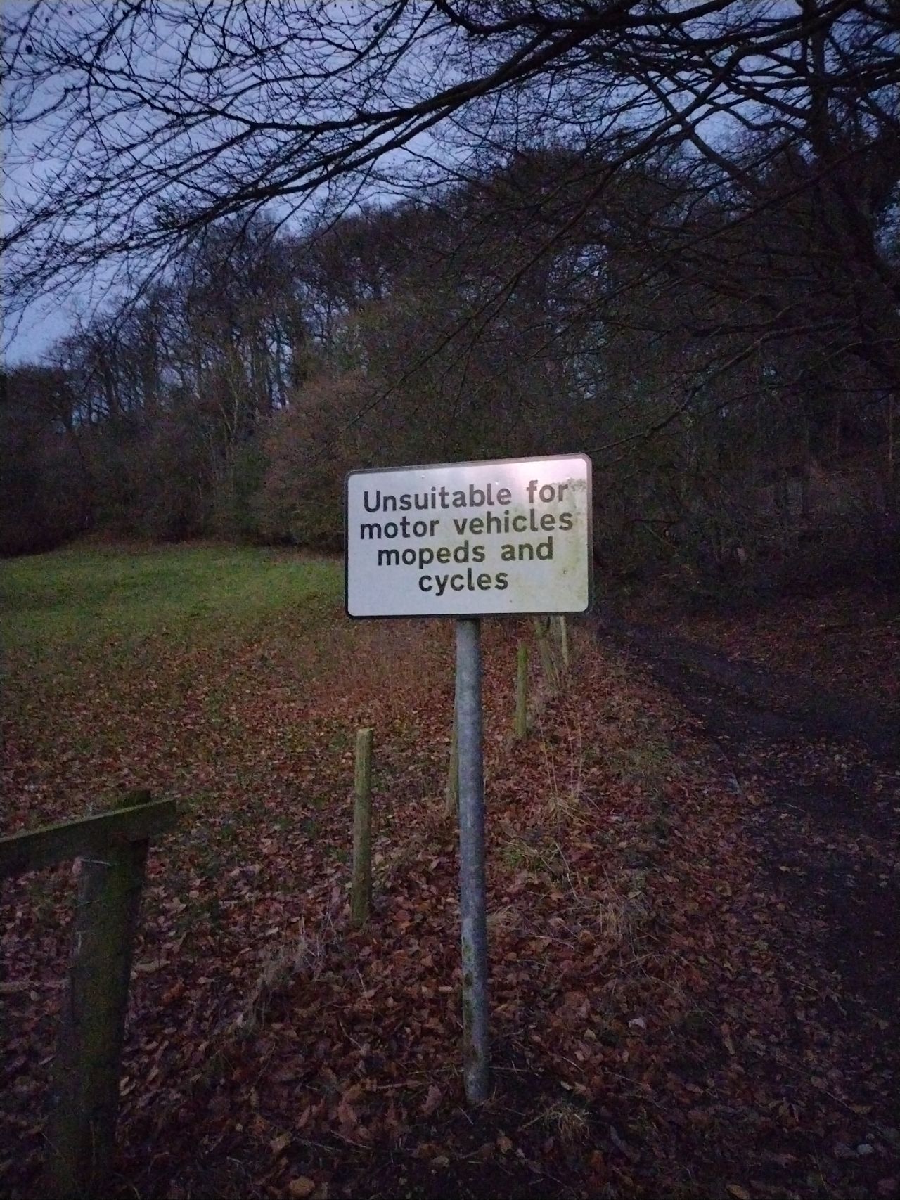
Posted by SomeoneElse on 1 August 2024 in English.
After reading this forum topic and commenting that the United Kingdom part wasn’t great because it didn’t consider the different rules in England and Wales, Scotland, and Northern Ireland, I wondered “what should the defaults actually be for England and Wales?”.
Of that table, I think that the rows down to living_street are correct, and of the remaining rows the columns across to moped are also correct. I decided to pick a couple of areas I’m familiar with (one urban, one rural) and look for examples in those areas without explicit access tagging. Based on that it should be possible to suggest some sensible defaults.
path
The default of no for everything through to moped is correct, which leaves horse, bicycle and foot.
path, horse, urban
https://overpass-turbo.eu/s/1P4E
https://overpass-turbo.eu/s/1P4G
Mostly these ways are https://wiki.openstreetmap.org/wiki/Tag:foot=permissive, and there’s no horse signage. In some of the parks horses might be tolerated; elsewhere likely not. This suggests https://wiki.openstreetmap.org/wiki/Tag:horse=no here.
path, horse, rural
https://overpass-turbo.eu/s/1P4I
https://overpass-turbo.eu/s/1P4H
Mostly these ways are https://wiki.openstreetmap.org/wiki/Tag:foot=permissive or =yes, and there’s no horse signage. In some of the parks horse access might be =permissive; in most cases not. This suggests https://wiki.openstreetmap.org/wiki/Tag:horse=no for these as well.
path, bicycle, urban
https://overpass-turbo.eu/s/1P4J
https://overpass-turbo.eu/s/1P4K
Mostly these ways are https://wiki.openstreetmap.org/wiki/Tag:foot=permissive. In a large number bicycle access is explicitly disallowed.
path, bicycle, rural
https://overpass-turbo.eu/s/1P4L
Posted by TBesse on 1 August 2024 in German (Deutsch).
Last updated on 7 August 2024.
Von der 13 Kilometer langen Hoheitsgrenze um Eppelborn aus dem Jahr 1767 wurden bisher nur wenige Grenzsteine in OSM kartiert. Daher konnte ich nun den Großteil der 49 (von ehemals 90) heute noch erhaltenen Steine neu erfassen (http://overpass-turbo.eu/s/1PoJ). Bei dieser Gelegenheit habe ich auch meine aus dem Jahr 2021 stammende Eppelborner Grenzstein-Tour überarbeitet und auf meine Website neu aufgespielt (siehe unter http://www.besse.de/buecher/2024_Eppelborner_Grenzstein-Tour.pdf). Darin sind alle vier Seiten der Grenzsteine abgebildet. Zudem wurden die Marker mit weißer Kreide nachgezogen, so dass man auf den Fotos eindeutig lesen kann, was hier früher eingemeißelt worden ist. Diese Vorgehensweise empfehle ich jedem Fotographen, der die noch fehlenden images zu den Steinen zu den Eppelborner Grenzzügen noch ergänzen möchte. Aktuelle images sollten jeden Grenzstein zieren.
Nachstehend wird ein Ausschnitt zwischen Dirmingen und Thalexweiler aus der 1767 Original-Aussteinungskarte aus dem BayHStArchiv veröffentlicht: