Toulouse
Users' Diaries
Recent diary entries
Rando des Pays au Viallet
Posted by ftrebien on 15 August 2024 in Brazilian Portuguese (Português do Brasil).
Last updated on 20 October 2024.
Em maio de 2024, o Rio Grande do Sul enfrentou uma enchente histórica. No interior, rios varreram construções e estradas às suas margens em cidades pequenas, e muitas pontes desabaram, criando caos e desafios logísticos na circulação intermunicipal. No começo achei que as pontes principais seriam reparadas logo e que as das rotas menos críticas continuariam danificadas por mais tempo, por isso não valeria a pena mudar o mapa, preferimos mapear informações mais permanentes. Mas logo o evento tomou proporções sem precedentes. O lago Guaíba superou o récorde de 1941, submergindo centenas de ruas na região metropolitana e gerando centenas de milhares de desalojados. Nesse período, retomei o trabalho remoto, cuidei de um familiar doente, ajudei um parente a sair do caos da Cidade Baixa quando foi anunciado que iria inundar, ficamos sem água em casa por uma semana (ainda bem que pude recorrer à doação de água potável das Fontes de Belém). Foi então anunciado que as águas demorariam semanas para baixar. Notando a fragmentação e imprecisão das informações oficiais, a instabilidade de serviços essenciais, as falhas em mapas comerciais em lidar com a situação, e preocupado que poderia precisar saber dos detalhes no caso de uma emergência, conversei com a comunidade local pra ver se alguém iria se opor e então decidi começar a mapear a nova realidade num lugar só: no OSM. Com o tempo, a Lagoa dos Patos também subiu, inundando as cidades ao seu redor. As últimas ruas afetadas em áreas urbanas só secaram no final de julho, e várias cidades da serra ainda tentam se recuperar da destruição, com pontes destruídas, pontes provisórias canceladas, balsas inoperantes, estradas obstruídas por deslizamentos, entre outras situações.
Im Lebacher Stadtteil Thalexweiler und auf seinem Bann sind 19 Wegekreuze erhalten geblieben (http://overpass-turbo.eu/s/1Pkr), von denen 2 aus dem 18. Jahrhundert Aufnahme in der Denkmalliste gefunden haben. Diese werden seit 30 Jahren vom Verein für Heimatgeschichte Thalexweiler e. V. gepflegt und von dem pensionierten Malermeister Walter Lesch restauriert. Unsere Wegekreuz-Tour wurde jetzt bei der Kartierung dieser Kleinstdenkmäler in OSM überarbeitet, siehe unter http://www.besse.de/buecher/2024_Thalexweiler_Wegekreuz-Tour.pdf
Das Foto zeigt eine kleine Auswahl an Wegekreuzen aus Thalexweiler:


 Reloj de sol del año 2015 en el instituto de educación secundaria Salvador Rueda, Polígono Carretera de Cártama. El reloj es fruto de un proyecto de María del Carmen Medialdea, realizado por las ceramistas Patricia Alba y David Márquez de la Escuela de Arte San Telmo. Fuente: trabajo propio (CC BY-SA 4.0) disponible en Wikimedia Commons.
He añadido la ubicación de los relojes de sol de Málaga a OpenStreetMap. Intentaré tomar al menos una fotografía de cada uno de ellos para documentarlos en Wikimedia Commons. La ubicación de los relojes de sol se puede conocer a través de una sencilla consulta a Overpass.
También he creado una propuesta ciudadana dirigida al Ayuntamiento de Málaga para recuperar el reloj de sol del parque de Huelin. Actualmente solo se conserva su soporte, una antigua muela de molino que ya casi nadie recuerda que fue parte de un reloj de sol.
Referencias
Posted by NADARAJ SARANYA on 14 August 2024 in English.
Last updated on 23 August 2024.
I did It. Successfully Completed 20 th osm Birthday Celebration Srilanka.
Celebration Date : 11th August 2024
Thank you all Speakers, Presenters and participants for making this 20th osm birthday celebration success. and once again thank you accept my Invitation. #Taichi Furuhashi #Pawan #Janjan Villar Orano #Priscovia #Sangeetha BC #Dibikshiya #Ark Arjun
Thank You So much everyone……

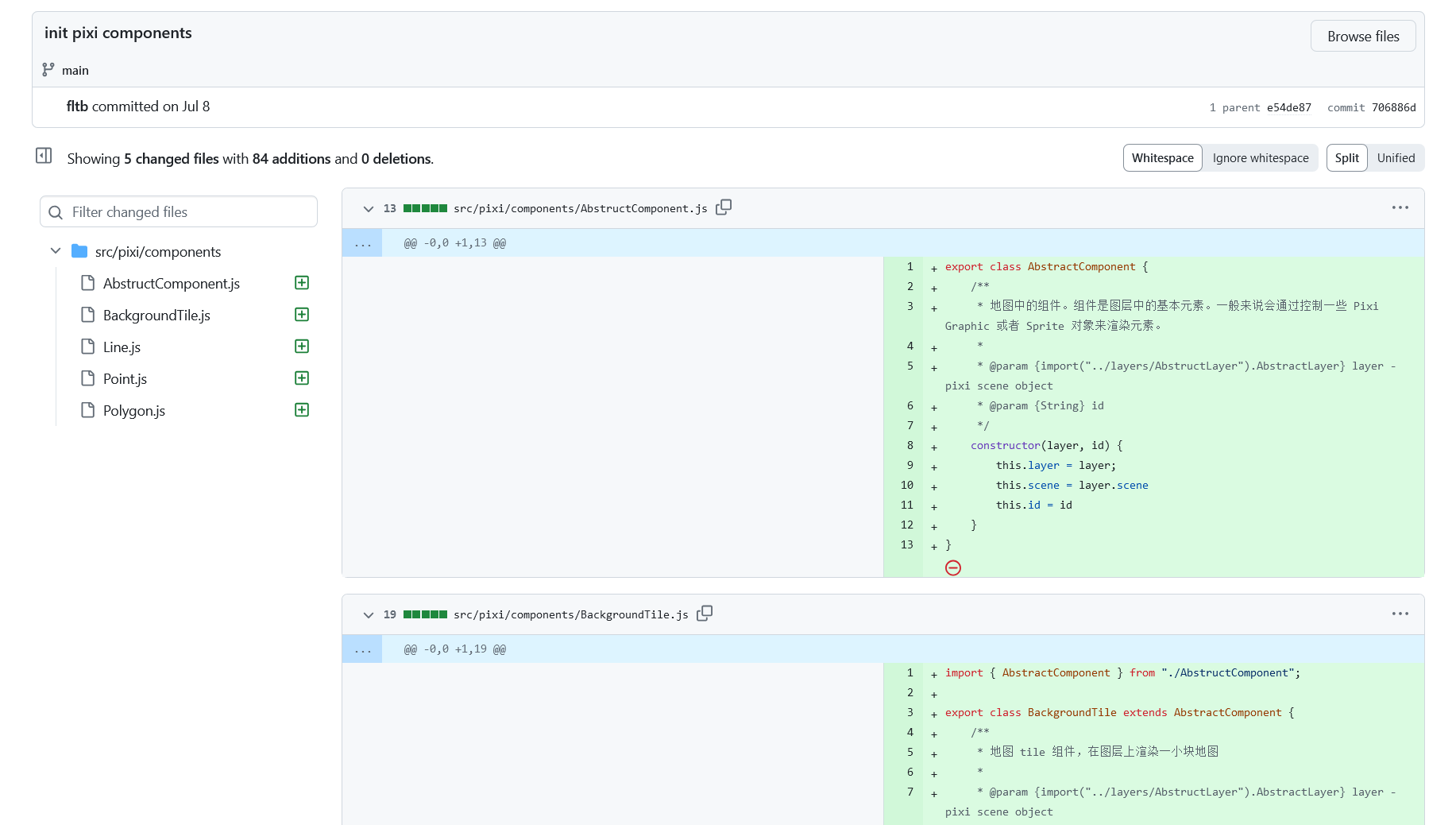
It’s been over two weeks since the last progress report, and it’s time to update on the current status.
Project Progress
The core modules of the project have now been largely finalized, allowing us to enter the latter stage of development. The upcoming work will mainly involve adding new features within the existing framework.
Render
Firstly, the rendering part has been set up, though there are still some details that need polishment, such as styles and elements controlling the rendering. These will be adjusted in sync with the subsequent feature development to ensure that the styling aligns with the editing logic.
API call and XML obj
I’ve developed an OSM API module that wraps some of OSM’s interfaces using Promises and parses the returned XML into a JavaScript object for easier manipulation within the program.
Editor’s status management
Following that is the editing module, which primarily includes the operation logic and global data management.
For the operation logic in map editing, I’ve introduced a state machine, which manages the current state of the editor by listening to mouse and keyboard events. The state machine, referred to as “stateMachine.js” in the code, handles state transitions and data maintenance based on the functions and state relationships provided in the state diagram. Depending on the current state, it determines which actions to trigger and the new state to transition into. The state machine provides hooks that allow other components, such as mouse events in Pixi.js, to track events. Editing operations are carried out during state transitions.

I was having a conversation with another mapper about the resolution of notes where the resolution of the note requires some local knowledge. These notes that require local knowledge may remain stale for a long period of time. You can read the full conversation here.
However, it is not uncommon that notes are resolved by people that are mainly interested in resolving notes. Anecdotally, based on the fact that I put in a lot of notes, there seems to be just a select few people that are going around resolving notes as their primary OpenStreetMap contribution, or at least a major part of it. I have all the respect in the world for these people. And to Danmer’s point, they don’t have enough help to get all their notes resolved, so leaving them unresolved, because notes only have two resolution options—they’re either open or they’re closed—can be challenging.
If the primary note resolution engine is people that most likely have no local knowledge, it is counterproductive to rely on that corps of people to address these notes that require local knowledge.
I think that we could probably classify notes into three categories:
- Those that anyone can resolve with just aerial photography and potentially some street-level photography.
- Notes that require some information that is not available with strictly what is presented to a remote editor, such as local knowledge, or something in the person who wrote the note’s mind.
- Spam.
casa 1

En todos mis viajes he visto muchos tipos de señales de tránsito, pero hasta noviembre del 2023, en un viaje a Matehuala, San Luis Potosí, vi esta señalización:

Agradezco el que mis amigos que conducian se detuvieran y pudiera tomar la fotografía.
Y finalmente, en este 20 aniversario de OSM, me di tiempo para subir la fotografía y mapear el lugar donde la vi.
¿Observaciones?
Son bienvenidas :-)

After years of development, I am excited to introduce a proposed feature for OpenStreetMap called Communities. Formerly called Microcosms, this feature is designed to bring mappers together and facilitate collaboration. On the main OSM website, it will be located on the Communities page.
What is Communities?
Communities are groups of mappers who share a common goal or interest. They can be formed around a specific geographic region, such as a city or neighborhood, or centered on a particular theme, like humanitarian mapping. The purpose of Communities is to provide a platform for mapping teams to connect with one another, work together as a team, and organize events.
Key Features
Oggi sono diventato un contributore di OSM
I’ve only been here since june, but it has been a really good time. Everything works really well and the community is really nice and has helped when I asked. Crazy that it is so old, some of the data I have edited is older than me*. This is a really cool project, thank you to the devs for all the work making it.
*just checked and it was very slightly younger than me
Posted by WanixRSGIS on 9 August 2024 in English.

My Journey as an OM Guru Fellow: Empowering Communities Through Open Mapping
Introduction
In January 2024, I embarked on an exciting journey as part of the OM Guru Fellowship program under the Open Mapping Hub - Asia Pacific. As one of the 50 selected Guru Fellows, I had the opportunity to join the Training Track, focusing on conducting training sessions, webinars, and mapathons for community members. This fellowship aims to foster a sustainable OpenStreetMap (OSM) ecosystem in the Asia-Pacific region by building the capacity of new and experienced mappers alike.
Getting Started
The fellowship began with an orientation, where we learned about the scope of work, our expected roles, and the various activities we would undertake over the next five months. As a Training Track Fellow, I was excited to engage with diverse communities and contribute to the open mapping movement by sharing my knowledge and skills.
Training Sessions and Webinars
During the fellowship, I conducted two online webinars and one in-person training session. These sessions were designed to cater to both beginners and experienced mappers, covering a wide range of topics.
Online Webinars
Posted by Jiri Podhorecky on 8 August 2024 in Czech (Česky).
Last updated on 14 June 2025.

Prostupnost, nebo ne-prostupnost území je vlastnost krajiny, vyjadřující, zda je mmožné v daném místě procházet pěšky, bez překonávání fyzických překážek. Týká se to jak člověka, tak třeba i divoké zvěře a hospodářských zvířat.
Možnost volně procházet územím bez omezení je v České republice , ale i ve většině civilizovaného světa, dána zákony té konkrétní země. Z nich vyplývá, že umožňují například volný pěší vstup do státních i soukromých lesů, pokud tyto lesy nemají zjevné oplocení, nebo jiný výslovný zákaz omezující vstup v místě, čase, nebo při konkrétní situaci.
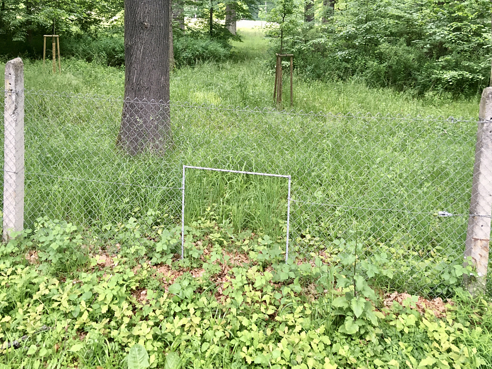
- oplocená obora u Červeného Dvora nedaleko Chvalšin. Plot má v sobě otvory pro prostup zvěře
Podobně vám asi nikdo nezakáže vstup na neoplocenou louku, stromový remízek, přístup k rybníku, řece, nebo na pozemek v krajině, kde není žádné viditelné značení, nebo překážka. Je pochopitelné, že jsou další zákony, vyhlášky a soukromé zájmy, které vám omezí konkrétní aktivity, ale jinak vám ve vstupu nic nebrání.
Тепер фактично немає жодного клаптика по цій карті в Барі, де щось не було мною розмальовано. тепер абсолютно всі об’єкти були внесені на карту. Тепер місто більше не є сірою плямою де нічого не було відомо.
Posted by Raquel Dezidério Souto on 8 August 2024 in Brazilian Portuguese (Português do Brasil).
Last updated on 16 August 2024.
O OSM faz aniversário, mas quem ganha o presente é você!
O maior projeto de mapeamento colaborativo global, OpenStreetMap, está completando 20 anos!
Para comemorar, o IVIDES.org promoverá uma série de oficinas, destinadas ao treinamento de novos mapeadores(as) e prática dos(as) demais participantes, em diferentes universidades do Brasil.
Para participar, basta preencher o formulário, uma única vez, e receber, por e-mail, os avisos das quatro atividades programadas, na véspera da data de cada evento.
https://ee.kobotoolbox.org/x/IvoihsNm
No último dia de evento, 30/08/2024, serão sorteados dois vale-presentes, para serem utilizados na compra de livros, entre aqueles que participarem de dois dos quatro encontros.
Esta é uma iniciativa do IVIDES.org, em parceria com o HUB YouthMappers Rio de Janeiro e colegas mapeadores(as) de todo o Brasil e de países amigos. Agradecemos à TomTom pelo patrocínio dos vale-presentes.
Não perca a oportunidade de colaborar com este projeto vencedor!
AGENDA
16/08 - 10:00-12:00 (UTC-3) - UNIPAR (PR) - Fundamentos do OSM e criação de mapa Web com uMap
20/08 - 10:00-12:00 (UTC-3) - UNIPAMPA (RS) - OSM na redução de riscos de desastres (RRD) + mapatona
23/08 - 16:15-18:30 (UTC-3) - COPPE/UFRJ - III GSEA/I SIGSEA (RJ) - Fundamentos do OSM e criação de mapa Web com uMap
30/08 - 10:00-12:00 (UTC-3) - UFF-Campos (RJ) - Fundamentos do OSM + mapatona + apresentação da TomTom
Obs: o formulário de inscrição foi criado com Enketo Express, é necessário ter o armazenamento de cookies ativado no navegador de Internet para funcionar corretamente. Se não conseguir utilizar, favor trocar de navegador ou ativar os cookies.
IVIDES.org® é uma marca registrada.
Posted by klfb75gxiy21tjrh on 7 August 2024 in Chinese (China) (中文(中国大陆)).
Last updated on 17 August 2024.
Español: Últimamente he estado haciendo algunas contribuciones a OpenStreetMap, a las que llamo “contribuciones que parecen inútiles pero en realidad tampoco son muy útiles”. Estoy agregando cables eléctricos, farolas y poste de telégrafo en el área de Penonomé en el mapa de OpenStreetMap. Sí, así de “aburrido”, pero me alegra hacerlo, ¿qué pasa? ¡Jaja! Pueden ver mi primera contribución en este plan en changeset/154954610
English: I’ve been making some contributions to OpenStreetMap recently, which I call “seemingly useless but actually not that useful” contributions. I’ll be adding power lines, streetlights and telephone pole to the OpenStreetMap map in the Penonomé area. Yep, it’s that “boring,” but I’m happy to do it. So what? Haha, you can check out my first contribution for this project at changeset/154954610
简体中文:我最近在对 OpenStreetMap 做一些贡献,对此我将其称为“看似无用但实际上用处也不大”的贡献,我将在 Penonomé 区域的 OpenStreetMap 地图添加电线、路灯和电线杆,没错,就是这么的“无聊”,但我乐意,怎么了?哈哈,你们可以打开 changeset/154954610 来查看我这个计划中的第一次贡献
Development has quickly progressed through two weeks, and it’s time to write a bi-weekly report.
Project Progress
The project is still in its early development stage, so we are unable to provide a usable prototype at this time.However, our implementation of the rendering part has been basically determined.
After testing, points and paths can be rendered successfully.
Due to the ongoing development of the interfaces for other modules, some functions have not yet been implemented. For instance, highlighting segments of a path instead of selecting the entire path as in the default logic of the iD editor. Also, the rendering of polygons has not been implemented yet because it requires the interface of the editing module.
We plan to divide the project into different components to facilitate future development and maintenance.