OpenStreetMap logo OpenStreetMap

Users' Diaries

Recent diary entries

Posted by gvwaal on 11 October 2023 in English.

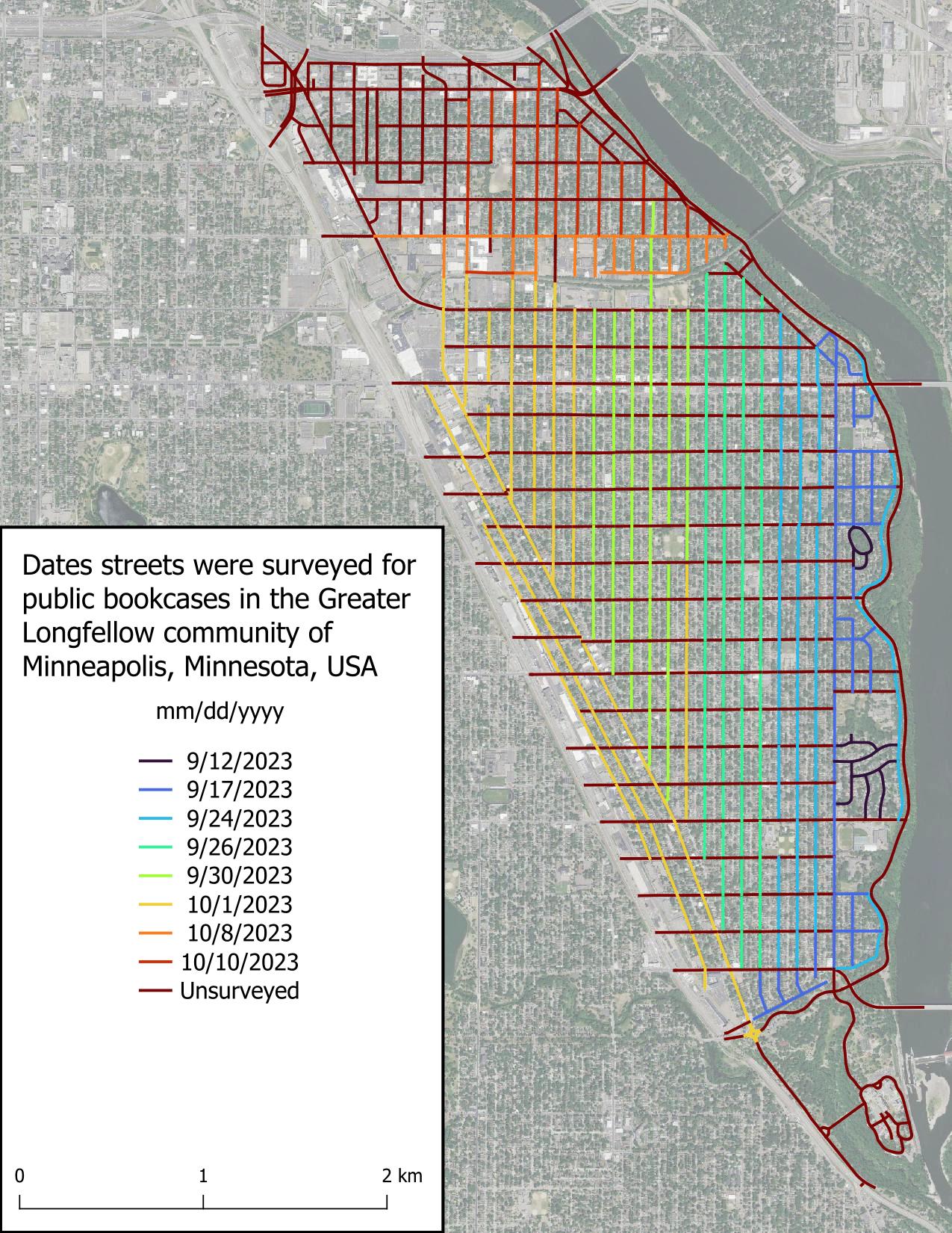
I really thought I was going to be able to survey all of the Seward neighborhood today, but it got dark more quickly than expected. That really hampers my ability to see public bookcases, as you’d expect. Good to know for future surveys. It’s a solid start.

The weather has become substantially chillier than September and that’s really impacting my motivation. I wanted to wrap up this project before the first snow, but I’m wondering if my expectations were too high. Time will tell.

I really appreciate the kind words folks have left on my previous diary entry. I didn’t expect to get any acknowledgement, which is fine, but people left comments yesterday, over a week after I posted it. What a nice community OSM has!

Intro

Figure displaying dates roads were surveyed in the scope area. Roads are colored based on date, with the earliest date, 2023-09-12, in very dark blue and grading to red for unsurveyed roads.

Just got into this, very new.

The staff of the Northern New Mexico Welcome Center in Chama NM tells people not to rely on their GPS around here because it tends to be incorrect. It’s true. Google Maps has the wrong businesses listed at a location, anywhere from a few hundred feet to over a mile away. OSM for the area is barely touched as many of the businesses and buildings are not demarcated in any way.

So here I go! Hoping to do some good map editing in the area and expecting some OG OSM editors to swiftly tell me what I’m doing wrong.

Posted by MKnight on 10 October 2023 in German (Deutsch).

… da verstehe ich diverse Dinge nicht.

Aktuell hab ich meine persönliche Challenge Gebäude in NRW von Über- und Unterschneidungen(Lücken) zu befreien und/oder zu korrigieren. Siehe auch

Da kommen mir recht viele Alkis-Dinge aufs Radar, bspw.:

  • Auf dem Luftbild sind Gebäude und/oder Gebäudegeometrien erkennbar, die weder in OSM, noch im Alkis sind -> stumpf nach Alkis abgemalt
  • bisschen in die Tiefe reinrecherchiert, alte Luftbilder, neue Luftbilder, alte CSe, neue Cse -> da ist nix abgerissen oder neugebaut, sondern stumpf nach Alkis, alles andere existiert nicht
  • es gibt einen extrem umfangreichen Fundus an 5-15-30cm Gebäude-vorsprüngen/vorsprüngchen/ecken/eckchen -> warum macht man sich so eine Kleinkleinarbeit? Und vor allem; wie sicher ist, dass Alkis an der Stelle wirklich richtig ist? (Ich hab mir auch da diverse Dinge genauer angeschaut und tendiere dazu, dass das Alkis in ca. 80% der Fälle OTG abbildet, ich habe aber auch genug Dinge gesehen, wo ich meine: das ist geschmiert/ schlecht kopiert, irgendwasanderes) warum macht man sich die Mühe so winzige Fürze abzumalen?
  • Beifang:
  • mutmasslich im Kataster später angebaute Essen (50x50cm), sehen im Alkis wie Gebäude aus -> also sinds Gebäude. Nutzen für OSM oder irgendwen: 0
  • mutmasslich später zugefügte Balkone -> Gebäude
  • Königsdisziplin: Balkonstützen/träger -> Gebäude … schlimmer gehts immer
  • Wenn man sich nun so einen übelsten Kleinklein”detail”mapping hingibt, warum ist dann am Ende alles voller Fehler?

P.s. Kramdown (und Markdown) ist der allerletzte unintuitive Husten, könnte im Kreis springen, so ein Hartmüll…

Posted by mbeyerle on 10 October 2023 in English.

See: https://en.wikipedia.org/wiki/Board_game_caf%C3%A9

How would you tag a board game cafe? The main attraction is the ability to ‘rent’ a table and play a variety of board games offered by the establishment. Oftentimes these places will sell cafe-type drinks and sometimes alcoholic drinks and food.

In my opinion, “amenity=cafe” and “amenity=pub” are not sufficiently descriptive because the implication is that the primary use is a cafe or pub, respectively. Adding a tag like sport=board_games or board_game=yes, while helpful, only indicate the availability of board games for play at a venue, but do not address the underlying issue that the primary use of the establishment is to play games not consume coffee or libations.

As a proud resident of Juba, the capital city of South Sudan, and a team leader of the OSM South Sudan, I’ve witnessed the winds of change sweeping through our beloved city. It’s a transformation that holds the promise of reshaping our lives, empowering our community, and charting a new course for Juba’s future. At the heart of this metamorphosis is Juba’s journey towards becoming an open-source city, a path significantly influenced by projects like #ASKNet Access to skills and Knowledge, Wikimedia Community User Group South Sudan and open mapping—a benchmark of this revolution.

Embracing Open Source: What Does it Mean?

Before delving into the profound influence of open mapping, let’s grasp what it means for Juba to be an open-source city. Essentially, it signifies a commitment to transparency, accountability, and active citizen participation. It’s a city where information flows freely, governance is collaborative, and innovation flourishes.

The Role of Open Mapping: Charting New Possibilities

Open mapping stands as a pivotal benchmark of Juba’s open-source revolution. It’s a movement that has profoundly impacted our city, unlocking new possibilities and transforming the way we interact with our urban environment.

1. Navigating the City with Precision: Juba’s dynamic growth posed a challenge for residents in terms of navigation. Thanks to open mapping initiatives, we now have access to detailed, up-to-date maps of our city. Whether it’s finding the quickest route to work or discovering a hidden gem in our community, open mapping has made life easier and more convenient.

2. Empowering Disaster Preparedness: The significance of open mapping came into sharp focus during times of crisis. It’s remarkable how open mapping has contributed to enhanced disaster preparedness. In times of natural disasters, such as floods, the ability to access real-time information about affected areas and potential evacuation routes is a lifeline for our community.

See full entry

Location: Hai Jebel, Nyokuron West, Munuki, Juba, Central Equatoria, South Sudan
Posted by Raquel Dezidério Souto on 10 October 2023 in Brazilian Portuguese (Português do Brasil). Last updated on 10 February 2024.

Mapeamento colaborativo

Recentemente, uma discussão entre mapeadores levantou a questão da utilização da base cartográfica mundial do OpenStreetMap, por entidades humanitárias internacionais, como os Médecins sans frontières (Médicos sem fronteiras), Red Cross (Cruz Vermelha), Humanitarian OpenStreetMap Team (Time Humanitário do OpenStreetMap) ou o UN Maps (programa ligado às missões de paz das Nações Unidas).

O projeto OpenStreetMap OSM teve seu início em 2004 e, quase 20 anos depois, conta com milhões de usuários e bilhões de feições mapeadas em diversas regiões do mundo. Para muitas destas regiões, os dados do OSM são os mais atualizados, ou mesmo os únicos disponíveis. Especialmente, em regiões rurais e distantes dos grandes centros urbanos, como diversas cidades das regiões Norte, Nordeste ou Centro-Oeste do Brasil [1].

Algumas campanhas de mapeamento (mapatonas), realizadas em resposta à ocorrência de eventos extremos, como inundações, movimentos de massa ou terremotos, produziram mapeamentos em tempo muito reduzido - como a mapatona da cidade de Petrópolis (RJ), realizada no início de 2023 e completada em apenas uma semana, após os eventos de deslizamentos de terra e inundação da cidade.

Ou a mapatona da cidade de Muçum (RS), realizada em 2023, cuja rapidez pode ser vista no vídeo elaborado por Fidelis Assis:

See full entry

Um evento especial

Entre os dias 31 de setembro e 04 de outubro de 2023, foi realizado o State of the Map Brasil 2023, evento que reuniu os mais ativos grupos de mapeadores do OpenStreetMap (OSM) e incluiu preleções sobre o estado-da-arte da pesquisa e desenvolvimento com OSM no Brasil.

Contribuímos na organização, com a parceria do Instituto Virtual para o Desenvolvimento Sustentável - IVIDES.org, e a apresentação de três palestras e uma exposição virtual - Amazônia no Mapa, com uma seleção dos mapas confeccionados pelos participantes da OBRAC 2023.

A Conferência foi promovida pela Universidade Federal do Paraná e coordenada pelo Laboratório Geoespacial Livre, em cooperação com vários capítulos YouthMappers brasileiros.

Curso OpenStreetMap 2023 - fluxo contínuo - certificados 2×/ano

➡️ PDF - https://l1nk.dev/8Q5bL

🎥 Vídeo palestra - https://www.youtube.com/watch?v=J_O36g7B6uY&t=120s

➡️ Website do curso - https://ivides.org/curso-osm-2023

Exposição Amazônia no Mapa

➡️ PDF - https://acesse.one/b00hD

🎥 Vídeo palestra - https://www.youtube.com/watch?v=J_O36g7B6uY&t=6793s

➡️ Atlas Digital - https://ivides.org/olimpiada-brasileira-de-cartografia-obrac-2023/exposicao-virtual

Apresentação do Capítulo YouthMappers UFRJ

➡️ PDF - https://acesse.one/m0dGv

🎥 Vídeo palestra - https://www.youtube.com/live/l1_ytUEImnc?feature=shared&t=36

🌎

Posted by AlmostSurelyRob on 9 October 2023 in English.

I’ve been diligently putting some truly boring information about my local High Street. Removing shops that don’t exist, adding new ones and adjusting opening times. It’s a shame businesses do not feel the need to do it themselves on OSM. I was wondering why is this, but then I realised that none of the navigation application I am using displays this information. I can check it on the Every Door and that’s pretty much it. Google Maps, by comparison, makes it really easy to see it and at the same time warns you of closing times, which makes it really practical in urban setting.

Having made comparison to the Map-That-Cannot-Be-Named, I realised how inaccurate Her* data is for my immediate neighbourhood. I’ve looked up some other places and though it would always take me more or less to the right location, the exact positions or addresses were off by quite some margin. At the same time, kudos to the interpolation heuristics that can find approximate addresses even in the absence of good data.

Especially that I am now realising how difficult addressing is. In my naivety I always though of streets as linear objects, with Hausdorff dimension 1 and ordered house numbers perhaps with an odd/even partition. Couldn’t be more wrong. I need to file a request to change the name of Dale Lane to Fractal Lane or Hausdorff Street (strasse?) to celebrate its many dendritic offshoots and arbitrary switch from consecutive ordering to odd/even ordering.

*Maps are feminine, right? Just like ships or cars.

Taking a brief look at the Croatian country side, one will notice that lots of the tracks/paths end without an exit. Additionally, when navigating at location, one will realize that only a fraction of such highways exist on the map.

How to plan a route for exploring?

The amount of exploration sections should reflect one’s physical capabilities. In the beginning about one exploration per route should suffice and can be increased through practice and knowledge of the area. One shouldn’t bite off a bigger chunk before one can handle it.

In this example of about 16km route

16km route throughout the east hills of Zorkovac, Croatia

I chose one exploration section every 5km in such a matter that not more than 500m of distance was needed to be explored.

There was one section in the north that was an easy gravel highway connection,

See full entry

Location: Bošnjak, Zorkovac, Grad Ozalj, Karlovac County, 47286, Croatia
Posted by b-unicycling on 8 October 2023 in English.

Boot scrapers have fascinated me since Helge Schneider’s musical “Mendy das Wusical” in which they play a very important role. #stiefelabstreifkante (It’s a somewhat absurd musical by my favourite German comedian…)

I remember that when I moved to Ireland I kept sending my sister pictures of the ones I came across, because she also likes the musical and the comedian.

For some years now I have been thinking that it would be interesting to map them. Partly because I wanted to know how many there are in Kilkenny and where and also, you never know who might be interested in this data in the future, so OpenStreetMap is the obvious choice to record them.

A.-K. D., CC BY-SA 4.0 https://creativecommons.org/licenses/by-sa/4.0, via Wikimedia Commons

At this point, if you get tired of reading - I’ve made a video about it: watch video on YouTube

See full entry

Location: Gardens, Kilkenny No.1 Urban, The Municipal District of Kilkenny City, County Kilkenny, Leinster, Ireland
Posted by b-unicycling on 6 October 2023 in English.

While I was mapping house numbers and other things in Ballyragget today, I noticed something curious: Buildings with “Step” or “Steps” in their name. There is a “Step House” in Ballyragget (check on OSM), probably called thus, because it has 5 steps leading up to the front door (a common feature in Georgian buildings). To my knowledge, there are only one or two more houses like that in Ballyragget, so having steps outside your front door must have seemed remarkable enough for people to give it that name.

A.-K. D., CC BY-SA 4.0, via Wikimedia Commons

Then two other cases came to mind: the Steppes Bar in Callan (check on OSM) which seems to be named after the steps to the left of the entrance. Weird plural, but maybe it’s from ye olde times.

See full entry

摩崖石刻

historic=epigraph 似可,但目前使用较少

窑洞

可能 man_made=cellar_entrance 较好?

最高峰另有命名的山

natural=massif 据其wiki页可用于此用途,然而用者寥寥,且不允许为点状。

绿化带

landuse=village_green 、landuse=grass 不允许线状。

停船处

mooring=*man_made=quay 不允许点状,leisure=marina \ amenity=ferry_terminal 允许为点状但前者是用来表示整个码头的(而不是泊位那块岸边)、后者专用于渡船上下客处。

宽阔的阶梯

似乎可以用 area:highway=steps

政府部门的院落

只有 amenity=townhalloffice=* 不加别的标签就会渲染成点。 landuse=commercial 直觉上就不对;字面上比较符合的 landuse=institutionallanduse=governmentallanduse=civic_admin ,用的人都少,前二者在wiki分别标为“有争议”,“放弃”,第三者倒是“使用中”但不在 landuse=* 页的列表里,且都不渲染。

驾校考场