Анива
Users' Diaries
Recent diary entries

I’m doing really, really detailed reed beds in Etulia Nouă, Moldova.
Moldova and it’s state
Moldova is not very detailed. In fact, most natural features aren’t even mapped. There are only roads, rough shapes of towns and town nodes. I’m currently creating lots of detailed reed beds and natural features there, especially near Lake Cahul.
Start detailing!
 I invite everyone to start detailing the undermined country of Moldova. It’s really beautiful! I’m detailing areas around Etulia Nouă, but you can pick any area you want, like Bălți, Giurgiulești, Comrat.
I enjoy reading people’s diary entries, so I’m starting my own. My current project is mapping public bookcases (PBs) in neighborhoods near me.
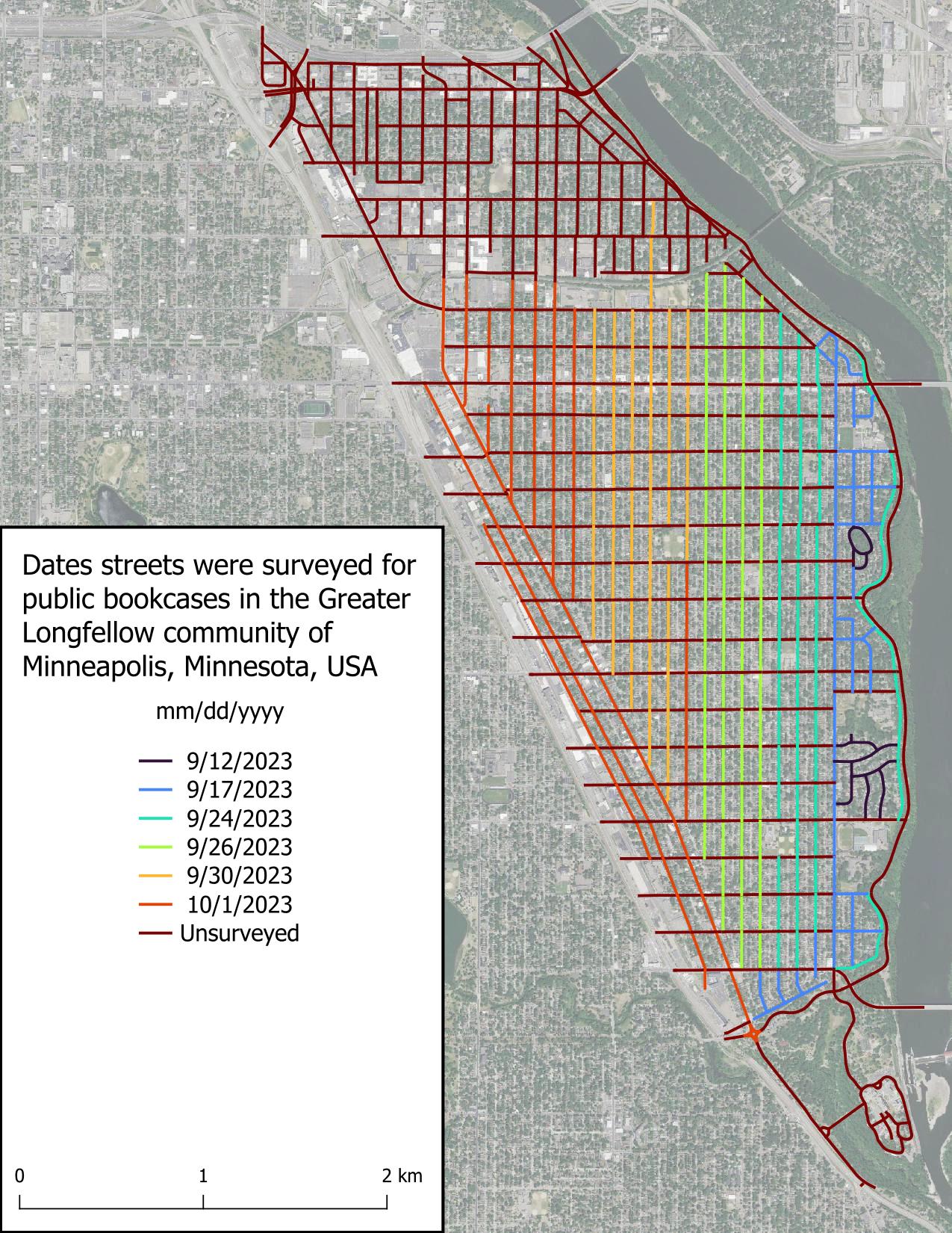
I started this project because I chance upon PBs when going for walks and can never remember where a PB is when I need one. There’s a map of Little Free Libraries (LFLs), but adding PBs to this map is “pay to play” which I don’t like, in addition to not displaying unaffiliated PBs. Other secondary goals include:
It seems I have developed a reputation in Ireland and the UK about my history mapping, because SK53 had tagged me in a toot about Martello towers. At first, I somewhat brushed it off, but as he probably knew, my interest was eventually triggered and I looked into the matter.
I remember that DeBigC was the first to tell me about Martello towers, but I can’t remember if he used a specific example or just shared his interest.
For those who aren’t familiar: Martello towers were built by the British Empire at a time when they were still ruling the waves, especially around the time of the Napoleonic Wars, when there was a threat of a Napoleonic invasion into British territory. They continued building them in port towns, so mostly along the coast, but not all of them are coastal. Apparently (according to Wikipedia), they are usually round and built in two levels with the guards living in it (i.e. building). They placed a cannon on the top which had a 360° reach, although one hopes that they only pointed it seawards.
The good news was that a lot of them were already mapped on OpenStreetMap, mostly with https://wiki.openstreetmap.org/wiki/Tag:name=Martello Tower. The bad news (as pointed out in the toot) was that there was no consistent tagging scheme. Most of them were mapped as https://wiki.openstreetmap.org/wiki/Tag:man_made=tower, and some had some sort of historic tag on them (ruins/ castle/ yes etc), but few were mapped as buildings. So, I came up with https://wiki.openstreetmap.org/wiki/Tag:historic=martello_tower, skipping the proposal process and documented the tagging scheme in the wiki.
مركز وامارة
In this post, I’ll try to give some insights into the more recent work and workflows of the global State of the Map (SotM) program committee. After having been a member of the SotM program committee for the last couple of years, I figured this might be useful or at least interesting for other program committees or content teams.
Please note that the views and experiences expressed in this post are my own and that they are mostly based on my memory. I’m also trying to just describe how we worked, which may not be the best way, maybe not even a recommendable one, but one that seemed to work for us. Just because it worked for us doesn’t mean it will work for others though, and vice versa.
In some way, this post is also a follow-up to a previous post of mine where I wrote about the software and services behind the State of the Map. I’ll try to avoid duplicating content, so see the previous post for more information about the tools and services that were used.
Organisation
As long as I’ve been on the program committee, it was always organised such that it was mostly split into a ‘core program committee’ (I’ll refer to it as ‘core team’ in the rest of this post) and the full program committee (I’ll refer to it as ‘program committee’ in the remainder of this post), which included all members including the core team. I don’t remember if this split was a conscious decision, if it just emerged based on asking the program committee members about who wanted to help with which tasks, or if there was another reason. But at least so far, we haven’t had a reason to change this.
Program Committee
The primary tasks of the program committee were reviewing and rating the submissions of the talks, workshops, etc. and providing feedback on e.g. the draft for the call for participation before it got published. Once the call for participation was published, the program committee members were also encouraged to announce it in their local communities.
Core Team

Mapping a large urban area in its entirety is quite a rare task.
Pyongyang, the city I mapped, is an urban area 15km wide by 12km long. It took me over a year from April 2022 to May 2023 to complete, particularly the buildings and roads. But I’m really pleased with the result: just look at the state of the map!
Mapping a capital in its entirety is rare, and for several reasons:
-
Firstly, because all the major urban areas in the West have already been mapped. This leaves the countries with the fewest contributors, whose capitals may already have POIs… but rarely all the buildings and roads.
-
Secondly, because you need a good amount of motivation, when you’ve reached the 60,000th building and you’re still halfway there… well… you have to hang in there! I also think it’s hard to imagine embarking on such a lengthy mapping project. Imagine if you wanted to undertake a project like this for Hanoi… unfortunately it can be discouraging from the outset.
But mapping by small parts, by neighbourhood, is a method that worked quite well for me, so maybe it will work for others!
In short, there are still many capitals to be mapped on these basic themes! But getting started, and above all keeping going, is a fairly difficult task because you need to stay motivated. If you do, hang in there!
Mapping Pyongyang
Beginning of the idea
When I started mapping in North Korea and writing the contribution guide to the country (cf. my previous diary) I never thought I’d be embarking on such a task because… it’s a capital in fact! It’s big, it never stops, it’s long, you never see the end of it! But in fact it is ;)
But I didn’t start mapping in North Korea by saying to myself “I’m going to map the whole capital”. In fact, for a long time I never even thought about it. In fact, it’s a project that’s taken place in several stages.
Posted by Britzz on 1 October 2023 in French (Français).
Last updated on 13 February 2024.
Posted by Аватар13 on 1 October 2023 in Ukrainian (Українська).
Тепер ще один кусок моїх рідних країв Барської громади Жмеринського району (колишній Барський), було описано і внесено на 100%. Цей процент не враховує об’єктів в селах.
- Sparse OSM tools: @ivanbranco/diary/401437
- OSM Links from another user diary: @GrapeMapping/diary/401815
- Quick interactive analysis of the map stats and how they evolve over time (e.g. “how many trees are in the map in Italy”), includes estimation of completeness https://dashboard.ohsome.org/
- Gallery of cartography projects, mainly about Berlin https://hanshack.com/
- 30 Day Map challenge: https://30daymapchallenge.com/
- Even more beautiful maps: https://tjukanov.org/
Posted by AlmostSurelyRob on 30 September 2023 in English.
Last updated on 25 November 2023.
… is what I am doing these days.
I’ve installed Terracer in JOSM software and I am learning JOSM along the way a bit. I also got Every Door on my mobile. It is much more versatile for correcting information about amenities than StreetComplete and at the same time still quite convenient to use.
Most of my tags still come from StreetComplete though. I find it particularly rewarding to answer questions for disabled or visually impaired people. I regularly see two elderly people on my local high-street and I see two kids, boy and a girl walking with sticks and I do hope that maybe one day the detail that people are putting into OSM will make some viable navigation apps for them. I also learnt about traffic lights with vibration mechanism underneath.
The difficulty is arbitrariness in tagging buildings. On the estate I live there’s a very old house which my wife describes as a “farm house”, but there’s no farm here any more and the building is used for residential purposes. I also learnt a very reasonable distinction between house, terraced or semi-detached house. I’d like to follow the tagging “building=house” “house=semidetached” or other to be more specific.
And how difficult must be to be a postman! Corner houses are particularly tricky. I came across semi-detached corner houses which seem to belong to different streets. There’s also lots of houses with names and no numbers and I think quite a few new blocks which do not exist on OSM. Will need to review with aerial imagery. I know of the offsets, but the GPS on my mobile is very unreliable so haven’t figured out yet how to correct it yet.

.

ថាកន្លែងល្អ

On September 26 IHE Delft and the Humanitarian OpenStreetMap Team organized a mapathon to map the areas affected by the earthquakes in Morocco and the floods in Libya.
Many new mappers attended the mapathon. We collectively uploaded 813 changesets containing over 50.000 total map changes in the span of only 3 hours.
Posted by Реdактор on 29 September 2023 in Russian (Русский).
Last updated on 25 January 2024.
.
Posted by Waaslander on 29 September 2023 in English.
Last updated on 16 October 2023.
Intro
The Belgian train operator NMBS (Dutch)/SNCB(French) is seeking to improve travelers guidance along its stations and for this it wants to improve the OpenStreetMap data quality of its stations osm.wiki/WikiProject_Belgium/Stations. One such project aims to have a better view as to where a certain train wagon would stop on a given track. This as to now exactly where the 1st Class wagon is, the bike wagon is and so on. However to be able to show this it needs a detailed view of platform zoning, the rail signs and the signaling. (Below you will find what those signals exactly mean.)
Zoning
What:
Some stations divide its platforms in zones. You have in general two types of zoning (I call those two types) general zoning and specific zoning platforms. On general zoning platforms you will find panels A B etc. besides the platform number. Often you will even see those numbers reoccur multiple times on a specific platform. On specific zoning platforms however you will find panels like B2, B1, A1, A2 and those are uniquely placed along the platform.
Posted by KlausG on 29 September 2023 in German (Deutsch).
direction: Blickrichtung vs. Geltungsrichtung
Das folgende steht im deutschen Wiki: “Die Tags direction=forward und direction=backward sind nur für Knoten gedacht, die zu genau einer Linie gehören. Stützt der Knoten mehr als eine Linie, wären diese Angabe mehrdeutig. Dann sollten Himmelsrichtungen für direction=* verwendet werden. Hinweis: Bitte die gegensätzlichen Bedeutungen bei der forward/backward (Geltungsrichtung) und bei Himmelsrichtung (Oberflächenrichtung) beachten.” Quelle: osm.wiki/DE:Key:direction
Upps, diesen Hinweis im Wiki habe ich übersehen: Gut dass mich ein anderer Mapper auf meine systematischen Falscheingaben freundlich aufmerksam gemacht hat und er und ich mit Hilfe von https://overpass-turbo.eu/s/1B5L (Danke an den aufmerksamen Mapper) wenigstens viele von mir gemachte Fehler mit relativ viel Arbeit wieder korrigieren konnte (ganz durch bin ich damit aber noch nicht). Das passiert, wenn man mit dem Lesen der Beschreibung zu früh aufhört, oder meint, man hat nach Jahren OSM-Mapping schon genügend Erfahrung. Ehrlich gesagt, habe ich das Wiki auch erst mehrfach lesen müssen, um diese scheinbare Widersprüchlichkeit zu verstehen.
Es gibt also eine tückische Fehlermöglichkeit beim Mappen von Vorfahrtszeichen, da mit direction zwei grundsätzlich unterschiedliche und zudem gegensätzliche (!) Eigenschaften beschrieben werden.
Geltungsrichtung
1.) Bei Verkehrszeichen wie highway=stop oder highway=give_way ist die übliche Methode, mit direction=forward bzw. backward in Bezug auf die in OSM angegebene Richtung der Straße die Richtung anzugeben, in der gefahren wird, damit das Schild gilt. bzw. “The directions forward and backward can be used to specify the direction of a feature relative to an existing way. This only applies to features which are tagged on a node that is part of a way. Examples may include directed traffic signs.” Quelle: direction=* Nutzung: m.E. wichtig z.B. bei Navigationsansagen
Blickrichtung/Himmelsrichtung/Oberflächenrichtung
Posted by AlmostSurelyRob on 28 September 2023 in English.
Last updated on 30 September 2023.
Right! I finally started using OpenStreetMaps.
Thanks to a friend who pointed me to Magic Earth I now have a viable navigation system which uses OSM data and thanks to StreetComplete I am slowly learning about tagging. The multiplicity of apps is not ideal, but a staged approach to OSM concept is clearly necessary. My previous attempts to become an OSM users failed because I was overwhelmed by complexity or perhaps I should say expressiveness.
In the foreseeable future I will be just using StreetComplete to improve my local area, but I am already seeing some issues that require more in-depth changes. Also, there are some edits that I have already submitted, but after reading the wiki I do not believe them to be accurate any more.
Here are a few topics I need to chase:
- terraced houses - the terraced houses in my area are all lumped together. They are not divided up, so assigning numbers requires usually a comma separated list. I would like to fix it and break the rows into single terraced houses with one number each.
- I need to figure out how to mark multiple buildings belonging to a school, church or a care home for elderly.
- terraced bungalow houses - I am guessing they are terraced houses as bungalow definition clearly states detached. My area has many rows of single storey houses
- I may have messed up some bollards by marking them as fixed, whereas in fact some are removable with key. Will need to keep an eye on this and maybe learn to use Vespuchio to fix those in the future.
- Sometimes I am not entirely sure whether a road is asphalt or concrete with some coarse aggregates inside. I was assuming it’s asphalt as that’s what we typically put, but maybe I should take some photos and ask someone who knows better.
Posted by asphaltisboring on 28 September 2023 in Russian (Русский).

- This post is a (machine) translation of the article “https://wiki.openstreetmap.org/wiki/Tag:‘돌비알’(natural=scree), https://wiki.openstreetmap.org/wiki/Tag:‘자갈밭’(natural=shingle), https://wiki.openstreetmap.org/wiki/Tag:‘너덜겅’(natural=blockfield) 견줘 보기” into English.
https://wiki.openstreetmap.org/wiki/Tag:natural=scree, https://wiki.openstreetmap.org/wiki/Tag:natural=shingle, https://wiki.openstreetmap.org/wiki/Tag:natural=blockfield
돌비알(scree;talus)
- Something like a rock, built up almost exclusively by weathering and crumbling.
- They build up as they are swept away, creating a steep slope.
- The stones that make up the talus are generally small or variable in size.
- Even if the stone masses are large, they are often sharp because they have not been worn down much.
- ‘scree’ in Wikipedia
