จ.เจริญยนต์ สาขา2
Users' Diaries
Recent diary entries

I’ve spent a few evenings and spare hours this week dusting off and updating osmdiff. If you’re a python developer and you need to interact with replication diffs or augmented diffs, this may just be something of interest to you. osmdiff can retrieve replication diffs as well as augmented diffs from OSM servers, and parse them into native Python Node, Way and Relation objects you can use in your code. This lets you do things like
>>> from osmdiff import OSMChange
>>> o = OSMChange()
>>> o.frequency = "minute"  # the default
>>> o.get_state()  # retrieve current sequence ID
>>> o.sequence_number
2704451
>>> o.retrieve()  # retrieve from API
>>> o
OSMChange (677 created, 204 modified, 14 deleted)
Once you have the data, you can filter and inspect it:
>>> w = [n["new"] for n in a.modify if n["new"].attribs["id"] == "452218081"]
>>> w
[Way 452218081 (10 nodes)]
>>> w[0]
Way 452218081 (10 nodes)
>>> w[0].tags
{'highway': 'residential'}
>>> w[0].attribs
{'id': '452218081', 'version': '2', 'timestamp': '2017-11-10T13:52:01Z', 'changeset': '53667190', 'uid': '2352517', 'user': 'carths81'}
>>> w[0].attribs
{'id': '452218081', 'version': '2', 'timestamp': '2017-11-10T13:52:01Z', 'changeset': '53667190', 'uid': '2352517', 'user': 'carths81'}
>>> w[0].bounds
['12.8932677', '43.3575917', '12.8948117', '43.3585947']
You can also use osmdiffs implementation of Node, Way and Relation objects separately if you need just those, the library is quite small and has few dependencies (just requests and dateutil)
On the list of things in development and slated for the next release are:
* Python __geo_interface__ support so you can easily use them in other Python modules that support them like shapely and geojson
* Retrieving individual OSM features from the OSM API
* Ability to create an AugmentedDiff / OSMChange object with a datetime parameter, which will then calculate the sequence number for you
* More tests, always more tests, and CircleCI integration
Posted by dcapillae on 13 October 2022 in Spanish (Español).
Last updated on 20 June 2023.

 Evolución del mapeado en el barrio Estación de Campanillas (ubicación) en OpenStreetMap. Fuente: trabajo propio y colaboradores de OpenStreetMap (CC BY-SA 4.0).
El mapa de OpenStreetMap en el municipio de Málaga ha mejorado notablemente respecto al mapeado de usos del suelo y de cobertura vegetal, tanto en cantidad de zonas mapeadas como en precisión de las mismas. La mejora ha sido posible gracias a la importación de edificios y direcciones actualmente en curso. Esta importación no tenía entre sus objetivos iniciales la incorporación de usos del suelo ni de cobertura vegetal, pero resulta bastante sencillo añadirlos al mapa en ediciones sucesivas una vez han sido importados los edificios.
Ausstellung
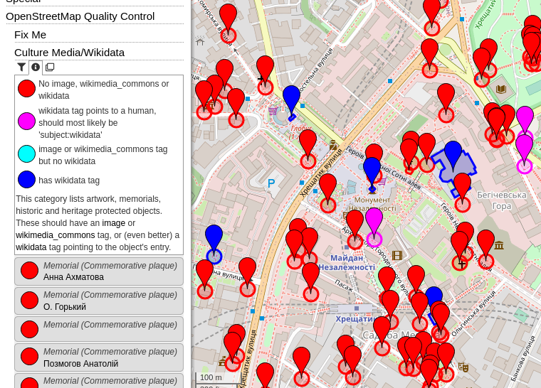
Recently I introduced a few “OpenStreetMap Quality Control” categories:
- Fix Me - All map features which have a “fixme” (or similar) tag, categorized by suffix (e.g. fixme:name) or content (e.g. “name wrong”). It can also filtered by type of feature (e.g. Shop, Road, …).
- Culture - Media/Wikidata - In my opinion, each cultural map feature (artwork, memorial, tourist attraction, …) should have an image and/or a wikimedia_commons category (red=missing, light blue=set). Often, there even exists a Wikidata item (dark blue). Many memorials erroneously have the wikidata link to a person (magenta), this should most likely be a “subject:wikidata” (resp. “subject:wikipedia”) tag.
- Wikipedia - This category was in the “Special” top category before. It shows all map features in the area with a wikipedia or wikidata tag (including prefixes, e.g. “subject:wikipedia” or “name:etymology:wikidata”).
2022 Board elections are coming up for OSMF. You can see what the details will be like on the wiki page from last year. There are three seats up for election, not clear yet who from current Board members will run again.
We need people to run who are focused on specific needs, and ready to put in professional level work on a volunteer basis. In other words, folks who can pick a 1 or 2 things, do good work on them, in service to our community. There are plenty of chunky problems that need ownership.
Me, I’ve been on the OSMF Board longer than anyone. I used to try to cover everything. Now my work in OSMF is very focused on 2 areas – personnel and fundraising. We need to look after our people and make OSMF a good place to work. And we need resources to make our plans happen. It’s a lot, but I’m limiting my time to these.
There’s a lot of noise and energy around any election, and that holds pretty true for OSMF. It’s the one time of year many think about the OSMF at all. But the real work happens in the rest of the year. Very little of the campaign manifestos really matter. Opinions and positions don’t really matter. Through strategic discussion, we largely agree on what needs to get done. Doing the work is what counts, and that’s what we need in Board candidates.
Jumping directly into the OSMF Board with no prior OSMF experience is hard. There’s lots to do on Working Groups and Committees throughout the year. Helps build reputation across our global community, and familiarity with how we function.
That said, whatever your experience, if you are ready to jump and put in the work, I’d love to support you. Reach out and we can talk. I can share my insights on the process and what it takes.
テスト
Posted by Albergarri788 on 12 October 2022 in Spanish (Español).

Me resulta extraño como pueden faltar tantos edificios y detalles básicos en una zona tan poblada. Aprovechando que conozco muy bien el lugar voy a tratar de completarlo al mínimo detalle

https://sccaz-gis.maps.arcgis.com/home/index.html
Santa Cruz County, AZ government website, contains links to shapefiles for building footprints, addresses, roads, etc. Need to request permission to import? osm.wiki/Import/Guidelines
Finally completed the mapping of the urban environment of Magog (Quebec, Canada). Addition of buildings (15K), major parking lots (700), adjustment of street geometry (3K). Added details on the boardwalk facing the lake.

Began the trace on 11 Oct 2022
Posted by AngocA on 10 October 2022 in Spanish (Español).
Last updated on 16 October 2022.

El contenido de este artículo fue enviado a: osm.wiki/ES:LatAm/Proyectos/Resoluci%C3%B3n_de_notas/Preparaci%C3%B3n_premios ya que el formato de los queries no funcionaba.

After many years, I finally decided to dive back into running a full planet import using the Overpass API.
To keep things budget-friendly, I rented a modest Intel-based server for around 40€/month — nothing fancy, just dual data center SSDs and 64GB of ECC RAM.
What surprised me was the runtime: the initial import using release 0.7.58.5 took a whopping 33.5 hours — at least 10 hours longer than I had anticipated. I managed to shave that down to 26.5 hours by tweaking some settings, like enabling LZ4 compression across the board and increasing the chunk size parameter. It helped, but clearly, there’s still room for optimization.
I continued testing with my own experimental Overpass fork, that includes support for PBF, multithreading, and many other changes under the hood. Initial measurements looked quite promising with 10.5 hours total runtime. After some further analysis and improving some data structures, the import took 7 hours and 23 minutes. Peak memory consumption was still quite ok at 22G. I tried different settings to achieve lower memory consumption, at the cost of longer processing time (e.g. 8 hours and 13G peak memory).
Depending on compression settings, the final planet database was in a range of 230-265GB.
Detailed results are available on this wiki page: osm.wiki/User:Mmd/Planet_import_challenge_22
That’s all for today.
I’m bemused
Why does a map editing software need a diary function?
It seems a little
- silly
- superfluous
if you ask me.
My Excitement
It was really a good and great feeling being part of the HOT interns for 2022, I am really excited about it and can’t really express it well. The internship has given me the opportunity to learn from experts, network and meet different people across the globe to share ideas, learn and impact our community through OpenStreetMap by providing quality data, I am becoming better day by day, I am gradually Improving on my mapping skill in another dimension with just few hours of kick off, Imagine me in couple of coming weeks, I am super excited about my Improvement.
I was Nervous too
I was nervous about not getting things right, it is really great and awesome, I am better than the way I came but mapping Project 12062 was a bit hard for me in Identifying building features. In my conventional mapping, any task I start mapping, I MUST finish it no matter how hard the task is but project 12062 challenged me because I found it difficult marking a task complete because I keeping thinking if that is building or not because the Imagery is coarse but I am gradually defeating my fear of not getting it right because I am improving and Validators feedback is really building my confidence.
I Learnt
- Learnt old way of Multi polygon
- Why turning Expert mode is important on JOSM
- Learnt more about Important of quality data
Week 1 Challenges
I never know it was hard somehow using iD editor because I used iD editor for 2 years before switching to JOSM and I have been using JOSM expect on training New OSMites in my local community which is just for demonstration. using it in mapping during my first week of internship was hard, stressful and funny as it is, I was even using JOSM Shortcuts on ID Editor
Courage and Relieving
The Validators feedback is really relieving and encouraging, I think i Will adopt the method of giving feedback. Validators feedback boost my morale and inspired me to do more, I will be using such feedback in future to inspire OSMites
City of Edmonton has an excellent data set to assist with entry into JOSM. navigate to https://data.edmonton.ca/ to locate data sets.
example: Street lighting https://data.edmonton.ca/Transportation/LED-Streetlights-Map-View/9xmi-y7kn
This is a giant data set, but data can be exported for use directly to CSV, XML, etc.. or you can further make use of the API to select a subset by clicking on the view source data:
rxke-mcvd : verify the right data set endpoint location radius (in m?)
https://data.edmonton.ca/resource/rxke-mcvd.geojson?$where=within_circle(geometry_point, 53.595, -113.479, 1000)
adjusting the circle to a suitable radius and location in the city to start working with the data, consult the API for more details on points vs geometry.
Once downloaded as geojson, import to JOSM to help with your edits.
Posted by SomeoneElse on 9 October 2022 in English.
Last updated on 20 July 2023.

The OSM wiki contains links to various downloads for Garmin maps, as well as some information about creating your own from OSM data.
For many years now I’ve used maps on Garmin devices that I’ve created myself. I’ve done this so that I show things like England and Wales public footpaths and bridleways that I’m not aware that other maps can show. Until now, I’ve never quite got around to making the mechanism publicly available, or indeed the maps themselves. I’ve finally got around to fixing that.
The “readme” here explains how to run the script yourself, if you want to do that. If you don’t, you can download the latest files for Great Britain. New maps should appear there about weekly.
Differences between these maps and other maps for Garmin devices include:
I hate it here. I miss 306 Harleston Road

Oggi 08/10/2022 inizio a registare i miei tracciati su OSM

State of the Map 2022 is over, so I’ll join many others in writing how SotM was to me.
The most unique and appeal thing for me about events like this is being able to meet people in person and talk to people I don’t often see. Alas there were so many people I’d like to have spent more time with. There were many people I met in person for the first time having only had online interactions, and many people I’d seen before.
All the talks are online (both on media.ccc and YouTube.com). “What you map is not always what you get”, is a good primer on OSM tagging.
The main social event was fun and in an interesting venue. It was nice how it was spread out, so you could easily mingle and talk to many people. I was affected by the mess up with the cards, but I got a cocktail & ice cream, so was happy 🐘 🐦.
I took part in the OSMF Board Ask Us Anything Q&A session. (video (media.ccc), (yt). It was a good talk. Lots of interesting questions. I hope I & the rest managed to answer enough. I’d like to manually improve the subtitles & translations. Someone asked about board diversity, and I made That Joke™🥚︎ to the lads after 😆︎.
The OSMF didn’t do the paperwork for the OSM Austria Local Chapter application, so we did a signing ceremony then. 🐦
I travelled by train from Karlsruhe to Firenze, took about 8 hrs but is good for the environment and more relaxing than dealing with airports. While I was quietly open at the last SotM, this was my first using my real name. Everyone in OSM were totally cool about it all (bar the usual suspects).
A week after I got back, I tested positive for Corona. 😭 I’ve 3 vaccinations, so I had a headache for a few days. I quarantined, which was a little dull, and missed some events. The vaccinations really work. I didn’t wear a mask as much as others at SotM (or afterwards). I guess I succumed to the social norms of “no mask” 😔.