
alexkemp's Diary
Recent diary entries
HU School Mapping Completed
Posted by alexkemp on 24 May 2020 in English. Last updated on 25 May 2020.Phew. ~200 schools.
Hull was my birth-town and where I lived until ~30. I have now lived in Nottingham longer than I did in Hull.
It was fascinating to see the scale of change in the schools that I know. I do not think that a single school that I attended or knew remains in use, let alone is unchanged.
- Infant & Junior schools; completely changed; twice!
- Grammar School; gone from site in entirety; all replacements across next 40 years also gone.
- School at top of 1st marital street replaced by domestic housing
- Son’s secondary school no longer exists
That’s Hull for you.
Now it is hello SA (Carmarthenshire / Sir Gaerfyrddin).
Tranby Croft, Hull Grammar School & Hull Collegiate School
Posted by alexkemp on 19 May 2020 in English. Last updated on 21 June 2022.We are still in Covid-19 Lockdown, I’m still diligently mapping schools in the HU (Hull & East Riding of Yorkshire) Postcode, and I’ve reached an interesting school near Anlaby that incorporates my family’s Alma Mater of Hull Grammar School (I wondered where it had gone).
- Hull Collegiate School (wikipedia) (https://wiki.openstreetmap.org/wiki/Tag:edubase=118126)
- Tranby Croft (HE listing) (wikipedia)
- Hull Grammar School (wikipedia) (Hull History Centre)
HE tags for Tranby Croft (these are specific for the UK):–
https://wiki.openstreetmap.org/wiki/Tag:heritage:operator=Historic Englandhttps://wiki.openstreetmap.org/wiki/Tag:heritage=2https://wiki.openstreetmap.org/wiki/Tag:listed_status=Grade IIhttps://wiki.openstreetmap.org/wiki/Tag:HE_ref=1103387
Hull Grammar School
JOSM HowTo: map buildings

After the glorious success of mapping Schools with JOSM it was obvious to produce a series of shorts showing how-to-map elements of the schools, and let’s start with howto map school buildings.
Less than 8 minutes long, it does what it says on the can; it shows how to map a school building.
-
The school (Rise Academy, Hull):–
way/803492600 - mathmos.net (choose a UK postcode)
- EduBase (England) (register of schools and colleges in England)
- my YT channel
…and now a YouTube Video on Mapping Schools
Posted by alexkemp on 12 May 2020 in English. Last updated on 15 May 2020.JOSM HowTo: map schools
(above: using roundabouts to align imagery offsets)
My very first video(s) uploaded to YouTube. The first is very long, very slow. Hopefully, an easy entry-ramp for those considering using JOSM to map for OSM. Otherwise, 35 minutes of boredom.
(later videos are much shorter)
YouTube Video Links
- https://youtu.be/-Uz_WhLh0Gg (general introduction)
- https://youtu.be/9RLe2vDv6s0 (JOSM HowTo: map buildings)
- https://www.youtube.com/channel/UCicHmqvromwnU5GXYYhjTZg (the YT Channel)
JOSM links
-
Download JOSM (use
alldist universefor Debian/Devuan) - JOSM: Installation help
- JOSM: General help
School Mapping links
(Noticed this for the 1st time)
-
Map Search for “HU3 6ED” at Historic England
(unfortunately, a useless searchpage, but does use OSM) -
Advanced search page at HE
(not honestly a great deal better, but more functional) - OSM HE_ref tag
- OSM listed_status tag
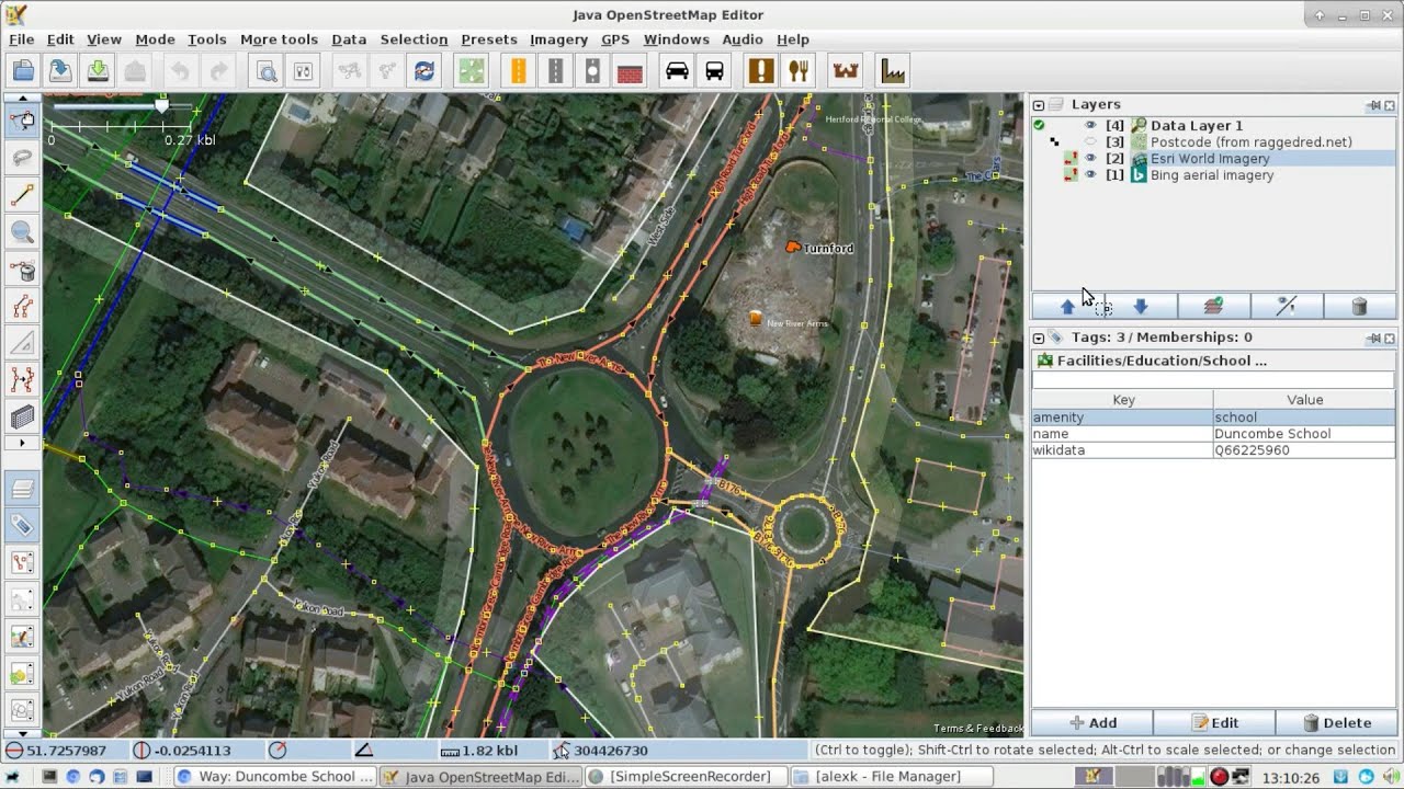
Ploughing through East Yorkshire schools, using a combo of mathmos.net & the government Schools Information Service to add full Address & Contact details to all HU schools, I’ve reached St George’s Primary School off Anlaby Road in Hull. Whilst checking that this was the correct school (very few EY schools — and how absolutely fantastic is it that the entire County has refused to accept the 1975 “Humberside” as their county & gone in their entirety back to “East Riding of Yorkshire”? yeah! — are properly mapped & registered, so it is necessary to check most carefully the mathmos.net correlation) I came across a photo showing on the front of the building that this was a “Board School”, and thus probably established in Victorian times (https://wiki.openstreetmap.org/wiki/Tag:start_date=1881).
I spent a little time living not too far from this school and, after completing the main mapping, began to try to find when it was built. That brought me to the Hull Carnegie Heritage Centre, where I discovered that the road was started in the 1870s & the school was built in 1881 by the Newington School Board in the very classic Gothic style of that era. The page also states that it is “now a Grade II Listed building and one of Hull’s oldest surviving school buildings”. And here it is (list entry:1197690):–
OSM in Practical Use — By an Irish School
Posted by alexkemp on 8 May 2020 in English. Last updated on 10 May 2020.Just to show how forward-reaching & intelligent the Irish are! You will find the OSM map in use at the extreme bottom of this Contact page for Hazelwood College, Newtownabbey, County Antrim:
It is a remarkably complicated set of <div>s which, at it’s heart, makes use of 4 x .png images to draw the map. It looks very professional (well done NI mappers!).
…and this map at the bottom of Hazelwood Primary School Contact page (just like buses, huh?):
**10 May update:
Having moved on to the HU (East Riding of Yorkshire) postcode, the 5th school I map shows an OSM map at the bottom of the page; hoorah!:
5 or more occasions each day currently I go hunting through JOSM imagery looking for road roundabouts. I’m not completely mad; they are the best way (short of making GPS tracks whilst personally surveying) to correct the Imagery offsets for Bing & Esri satellite photos.
The above has happened so frequently lately during this Lockdown period (not being able to go out & survey) that I’ve become utterly obsessed with them, spending half the day, on one occasion, hunting out grass-filled roundabouts to map.
I’m currently mapping schools in Northern Ireland, and the Irish have just a bare fraction of the number & variety of road roundabouts that we English have. However, what I have observed them to have is large road-enclosed circles within their fields. Don’t believe me? Well, I’ve observed more than one. Here is the latest, which I mapped (due south of Downpatrick):
What on earth is that about?
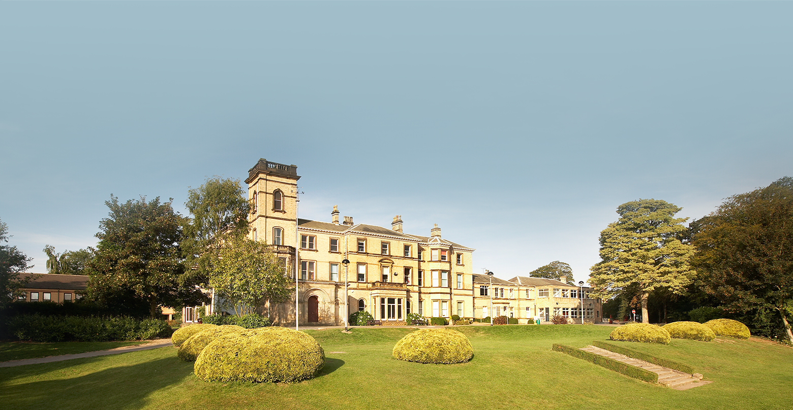
St Edmund’s College, Hertfordshire
Posted by alexkemp on 5 May 2020 in English. Last updated on 12 May 2020.I’m astonished at the quality of Herts. schools and, so far, all in close proximity to Ware.

This is a 400 acre site for a co-educational, Catholic college originally established in 1568. It was founded on that date in Douai, France, as a seminary to train priests and (later) also a Catholic school for boys. It transferred to the current site in England in 1793 to escape the depredations of the French Revolution. Girls from the adjacent Poles Convent were first admitted into the Sixth Form in 1975, and the College became fully co-educational in 1986.
St Edmund’s uses the founding date to claim their school as “the oldest Catholic School in England”.
I’m hoping to be able to construct a relation of all the site features, as with Haileybury and Imperial Service College, and have left a message on their answerphone. I’ll bring this little missive up to date if they respond.
Ermine Street
I seem to keep mentioning in these diaries schools that are close to Ermine Street.
Mapping Schools Preset: the ‘Operator Field’
Posted by alexkemp on 4 May 2020 in English. Last updated on 5 May 2020.This is now the 5th month since I began mapping schools as something useful to do during this wretched Covid-19 Lockdown period. 1,000s of schools updated with both Address & Contacts tags, and still I’m having problems with the Operator tag (the second item in the Preset).
Shortly after starting the mapping I got (rightly) slapped around the face by someone butt-hurt because I had wrongly mapped a school Operator that he had previously mapped, but he could not tell me the correct operator for that school anymore than I could tell it. Clearly, I should have left it blank rather than guessing. I thought in my innocence that, after some more experience, I would learn to know where to find the school operator. That hasn’t really happened. Hence this Diary entry.
These are the types of schools that I’ve currently come across (below), plus my best estimate of the operator to use. Do not hesitate to pitch in if you believe me to be wrong or know the operator:–
I maintain each day an ODS (LibreOffice) Spreadsheet of Covid-19 infections for Nottingham (my home town) as reported by ONS (Office of National Statistics) via a BBC webpage.
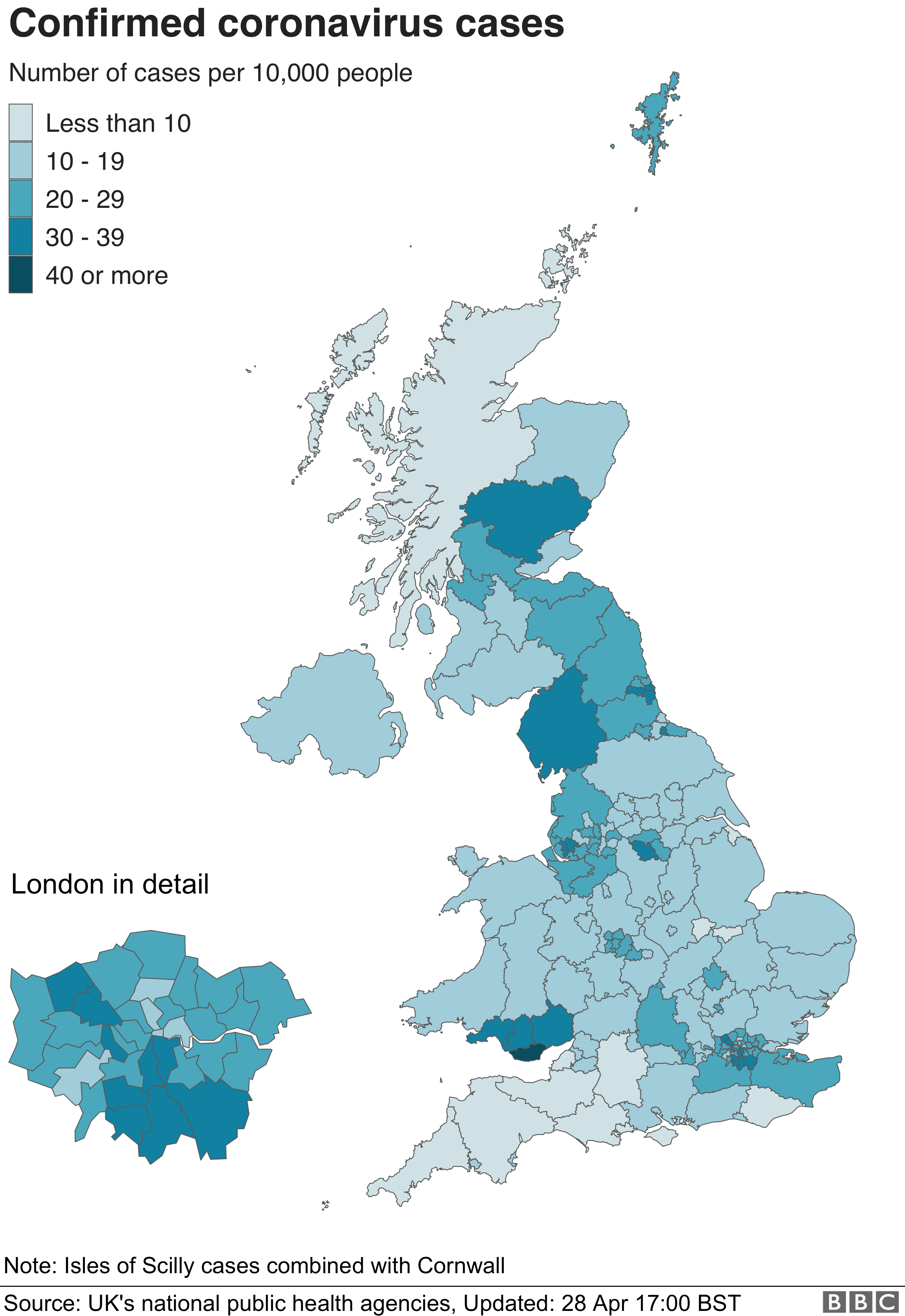
That page currently (08:45 29 April 2020) reports the same number for Nottingham (488 confirmed cases, from a population of 331,069 people) as it did the previous day (28 April), with a report date of 27 April. So, I went hunting for the source & found it on a .gov.uk site:
https://coronavirus.data.gov.uk
Coronavirus (COVID-19) in the UK (Open Government Licence v3.0)
…and lo! That page is using leaflet + OSM data (good attribution) to display the data.
Haileybury and Imperial Service College, Hertfordshire
Posted by alexkemp on 24 April 2020 in English. Last updated on 28 April 2020.My last Diary was a HowTo on using JOSM to create a Relation to map Heath Mount School. Heath Mount was founded in 1796 & occupies 40 acres of the Woodhall Estate close to Ware in Hertfordshire. Now, just to show that some people & places may be created more equal than others, here is the Haileybury and Imperial Service College, which is also close to Ware & occupies 500 acres. This one has been a little bit more of a challenge to map.

◦ Haileybury College (OSM map)
◦ Haileybury College (OSM relation - 130 members)
The bulk of the mapping is complete for this College (85 different items so far) but lots of buildings still to follow.
First a quick bio, then mapping highlights:
Was it only yesterday that I finished NG school updates, then started working through schools within SG postcodes? For some reason I hit a couple of complex multi-site schools straight away, each of which gave mighty problems. The most recent was the fabulous Heath Mount School (incongruously the relation looks like a fish swimming to the left). My grandkids were due to attend that school until parental divorce intervened.
I find that documenting stuff helps to cement the lessons learnt, as well as giving me something to refer to if I forget, and hopefully will help other novices as well. So, here are some small techniques to use with JOSM to help get the job done, drawn from very recent experience.
School Layout: Look for an Architect PDF
Heath Mount School: relation/11018342

Results so far & Intelligence Gathered on School Updates
Posted by alexkemp on 13 April 2020 in English. Last updated on 23 April 2020.March 24: School Work starts
April 2: School Work update
Across the last 23 days of this Covid-19 Lockdown I’ve made 526 changesets, almost all updating schools & colleges in the NG UK-postcode area. I’ve been working my way down the osm.mathmos.net website page for NG from top to bottom, and am about ⅔ of the way down. The last entries added were 11 campuses for Nottingham College. This diary entry is an attempt to synthesise the intelligence gathered so far.
The definitive list of schools, etc is maintained by the UK government & published at School Information Service. Each school is given a unique URN. The OSM reference to relate to this is https://wiki.openstreetmap.org/wiki/Tag:ref:edubase=URN-Number.
Where you see the word “School” below it also refers inter-changeably to “Colleges” or “Universities”.
1. Use a Roundabout to Align the Imagery
We have a number of different imagery available to use, but all of them both need to be aligned to the ground truth & every time the map location is changed each may need to be re-aligned. The simplest & best way that I have found to do this is to zoom in on a mini-roundabout, and to align the Offset to that roundabout.
The overview is like this:
Satellite view & GPS coordinates need to be aligned to each other based on a vast array of factors: eg angle of view, ground height above sea-level, GPS coordinate system, etc.. It is made more difficult because individual tiles may come from a large range of dates and/or satellites. It would also be wonderful if all of that had been pre-processed between the native image & production of tile-to-view, but we are beggars & not the paymasters & are lucky to have any imagery to use at all. Fortunately, we Brits are obsessed with roundabouts and there is always one close to where we are mapping. Further, OS street-mapping from the government has been imported for all Britain.
Here is the process step-by-step:-
Update on my School Work
Posted by alexkemp on 2 April 2020 in English. Last updated on 11 April 2020.March 24: School Work starts
As best as I can tell I’ve only worked my way through 69 schools. It seems far more. There are more than 223 changesets made by myself under this banner, and I was trying to do one changeset for each school or set-of-schools in the same immediate area. I think that what has happened is that the number of schools listed on the section of the page that I’ve worked on have shrunk as I have mapped them.
I began using https://osm.mathmos.net/schools/progress/NG to update all school info within OSM in the NG (Nottinghamshire) postcode on March 24. You can see all postcode links at https://osm.mathmos.net/schools/progress/.
osm.mathmos.net
The osm.mathmos.net site was promoted by a diary post by CjMalone. It gathers info from the get-information-schools.service.gov.uk site on current schools and cross-references those against UK schools mapped within OSM. Each top-level postcode gets it’s own page, and within that page the site lists (in order):-
- Schools apparently not mapped in OSM
- Schools in OSM not matched against the official list
- Schools matched in OSM by location but not edubase ID
- Schools matched in OSM by edubase ID
School Cadastre
In the last 9 days I’ve worked my way through all the first 3 sets of schools in the lists above. I’ve entered missing Cadastre (the perimeter of the school land parcel), and fixed them where they were wrong.
I also tried but failed to find the govt opensource download for those cadastre. Finally, Christian Ledermann mailed me with the link to his github for his App that contains those Cadastre. Unfortunately his site is broken (logging into OSM gives a Status 500 error back from his site), but it originally did work and put all necessary info on the OSM way. Bugger! Just when I needed it, it is not working.
Something Useful to do Whilst in Covid-19 Lockdown
Posted by alexkemp on 24 March 2020 in English. Last updated on 25 May 2020.Above is the link to a recent Diary from CjMalone with info on using osm.mathmos.net to obtain a list of all the UK schools mapped in OSM within a particular Postcode, ordered by how well they correspond to the UK gov.uk site.
I’m a pensioner and am supposed to slowly rot within my home without any socialisation with any other human. So, no change there. However, whilst we are in that Lockdown state — I’m over 70, and therefore have been instructed by the government to stay isolated at home — I may as well do something useful. I’m currently working my way through NG, and have just completed the 28 Nottinghamshire schools that osm.mathmos.net could not match up with a school at all. That has taken me 3 days. Phew! I’m either superb in my coverage or (far more likely) just very slow.
f12|Remote Control:
If using JOSM, then a useful shortcut is to enable Remote Control (Preferences: f12|Remote Control (LHS vertical column icon)|click in tick-box for 'Enable Remote Control'). Within your Web Browser, be sure to disable all Script restrictions for OSM, else there can be no inter-connection. Then, with JOSM launched, and whilst logged in to your OSM account in a browser, and with the relevant part of the map active (for me at this instance: way/55316126), click on the browser Edit drop-down and choose Edit with Remote Control. You can now switch to JOSM and that Way is waiting for you to edit it. Be sure to disconnect the Remote Control facility after use unless you want your computer to (possibly) be open to the internet.
ref:edubase:
How to Stop the Spam/Abuse
Posted by alexkemp on 6 August 2019 in English. Last updated on 12 October 2019.Before
This was originally posted by myself on 12 May 2019 as a response to the then–current astonishing volumes of “wfgz spam” & “vip spam” affecting these Diary pages (upto 30,000 spam-posts each day, starting 25 April). That existential threat appears to have receded (see the first part of the Bot-Flood Stats page), but the continual background trickle of spam– & nonsense–posts (upto 10 a day) continues.
It should be possible to easily shut off that vile flow without badly affecting valid OSM users. This post reflects on the current situation, and seeks to present my own suggestions and to provoke comments to perhaps obtain even better methods.
Institute a “No-edit, No-diary” rule.
All current spam & abuse would stop the instant that the privilege of posting to this Diary was restricted to those that have added to the map. My suggestion would be a parameter of ‘10 changesets’ to relax that rule.
There are further steps that would need to be taken to make sure that such a rule would not cause collateral damage to the map:
-
Moderate New-User Map Edits
Map edits by new users should be human-moderated by being placed into a hidden queue. A team of volunteers that are seasoned mappers can then be assigned Moderator rights to accept/reject map-edits within the hidden queue. Such moderation should only be lifted once the user has shown themselves to be a human with (say) 10 useful map edits. Diary posts would be auto-prevented until the statutory number of Map edits was completed. Once completed that restriction would be auto-removed. -
Auto-remove Unused Accounts
Auto-remove all those that acquire an OSM account but never update the map within (say) 2 weeks.
Background
OSM Diary pages both share features in common with blogs, forums, etc. and at the same time are different. The features shared in common are:–
OpenClipArt suffered DDOS in early May, Still Offline today
Posted by alexkemp on 18 July 2019 in English. Last updated on 19 July 2019.6:53 am - 3 May 2019 — UPDATE: Our plan is to get the site back online early next week. Under DDOS attack from some unknown forces, the simplest thing to protect our beloved Openclipart is to keep offline at present. Your CLIPART is SAFE.
I was trying to obtain an EPS pair of scissors this evening using File | Import Clip Art… under Inkscape (which is setup to use openclipart.org by default) but got zero result, not even an error message. The OCA index page showed a most peculiar message (“Openclipart is PROTECTED.”) which did not help someone in my position that was unaware of the cause. Then finally DuckDuckGo got me there to twitter.
You will see that these OSM Diaries also suffered constant bot attack starting late April which caused the site admin to take them offline from Search-Engines on 24 May (and again on 23 Jun) as to stop the attacks. It surely cannot be a coincidence that two non-commercial sites run by volunteers both suffered DDOS attacks within a few days of each other, causing both admin to hide their sites from public view as to mitigate the attacks. Of course, the reason for those attacks is still currently unknown.
The nature of these DDOS attacks is also uncertain. OSM used the site-wide robots.txt (see also diary/390115) to stop the bot-flood (OCA does not appear to have a robots.txt). That was physically enacted by two ‘Disallow’ lines in the text-file:
Disallow: /user/*/diary
Disallow: /diary
If you understand that the Robots exclusion standard is advisory, a little bit of thought will make it obvious that the fact that the bots stopped when the above was placed into robots.txt means that they were spam-bots. However, there were zero links or spam within (most of) their posts. Further, DDOS actions are almost always as to extract large amounts of money from the victims (it is effectively a technological mugging). What is the point in mugging non-commercial sites?
Before
This was originally posted by myself on 5 June 2019; it is another Diary as part of mapping Nottingham’s Creative Quarter, this time musing on Points of Interest (PoI) as part of mapping for OSM.
One of many reasons for entering PoIs in the map is that Nominatum (the search facility within OSM) uses PoI to find results including (amongst other items) postcodes. I discovered this when I could not find the Covid-19 Jabbing-centre in the OSM map, yet confirmed afterwards that I had entered the correct postcode.
A conversation with the lady at AST Auto Centre
I could not be certain either from my original visit nor from our Bing imagery whether some central buildings were occupied by the Ashley St. Auto Centre (below) or by a business on the opposite side of the block on Handel Street, so phoned the number on the business card that the lady at AST had given me on 17 May. This was 4 June so I did not expect her to remember me but she did, and mentioned the little leaflet that I had given her.
I quickly sorted the original reason for the call (AST occupies those buildings), but as soon as I mentioned OSM she immediately responded about the number of enquiries that the business gets via Google maps (I had never mentioned Google). I brightly informed her that the updated mapping should be available within the next hour.
Before
This was originally posted by myself on 6 May 2019. It is an attempt to document the then-recent spam/abuse problem within these Diaries in a scientific manner. The idea was to allow the wider community to get a fuller grasp on the issues and help answer some fundamental questions. After all, nobody knows everything. Here is my attempt to state some of those questions and to try to answer some of them:–
Some Questions:
- Is this Spam, Abuse, or a mixture of the two?
(the motivation behind those two are completely different) - Are they bot-posts, human-posts, or a mixture of the two?
(prevention mechanisms for those two differ) - What are the best methods to prevent this from continuing?
(best practices have been evolved across the last 20 years, but OSM is not your typical forum/blog)
Some Answers: