SomeoneElse's Comments
| Post | When | Comment |
|---|---|---|
| A Shortbread map style that looks a bit less beige | @Zverik OK, fixed. https://map.atownsend.org.uk/vector/index_osmf_shortbread.html#17.59/59.389977/24.717497 looks more sensible now. There are a couple of other bugfixes that could do with merging into this style too; I’ll do that as time permits in the coming days. |
|
| A Shortbread map style that looks a bit less beige | That’s a In the style that I used the cartography from I eventually changed that (see https://map.atownsend.org.uk/vector/index_svwd01.html#17.59/54.551428/-1.904913 ) so it should just be a case of merging that change into this style too. |
|
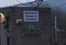
| Rearranging the world around Nominatim for fun and profit | Obviously me using traditional counties in the example above is a bit of a joke, but some people do seem to take it seriously. I was in this pub earlier today, and the landlady was very insistent that it was in Yorkshire not anywhere else. She’d agree with my joke server about the county: although it’s chosen the street name from the back door rather than the front. Further up the road the museum has this sign on the wall:
so it’s not just her! |