Nutchanon Wetchasit's Comments
| Changeset | When | Comment |
|---|---|---|
| 63399622 | almost 3 years ago | The time I'd usually walk pass there would be late in the night, so I have never gotten inside (it's way outside their opening time), and I don't usually have business to; I merely documented what I could see from the outside back then. And no, I will not go there during their opening time just to find out about this, not anymore: I no longer participate in OSM since 2019, after corporate armchair mappers overran what I surveyed (as now stated in my OSM profile page). So, I have no answer for your question; sorry. |
| 44864866 | over 6 years ago | There's no 7-Eleven near Thewet Pharmacy, the nearest one is either across the canal <way/548875640>, or at the next driveway <node/2620924882>. This edit is now partially reverted in changeset/72420366 <changeset/72420366>. |
| 72085011 | over 6 years ago | การแก้ไขนี้ ทำถนนอรุณอมรินทร์ขาดแหว่งไปท่อนหนึ่งนะครับ ผมได้ย้อนส่วนที่ผิดพลาดตรงนี้กลับให้แล้ว ในชุดการเปลี่ยนแปลง 72086445 <changeset/72086445> เวลาแก้แผนที่ ก็ระวังหน่อยแล้วกันนะครับ, ถ้าเผลอไปกดเปลี่ยนอะไรแบบไม่ได้ตั้งใจ ให้ใช้ปุ่ม Undo ย้อนกลับนะครับ ก่อนที่จะไปแก้อะไรอย่างอื่นต่อ ----- This edit accidentally removed a part of Arun Amarin road from the map. I have reverted this mistake for you in changeset/72086445 <changeset/72086445>. Be careful; if you accidentally changed the part you didn't mean to, use Undo button before continuing to edit other parts. |
| 63451451 | over 6 years ago | - This edit created a duplicate China Town Gate POI instead of adding to the existing one <way/342812020>.
This edit is now completely reverted in changeset/72085641 changeset/72085641>. |
| 71922487 | over 6 years ago | อย่างแรกที่ผมคงต้องย้ำสักนิดคือ การปักหมุดเปล่าๆ โดยมีแค่ชื่อบริษัทแค่อย่างเดียว ไม่เพียงพอที่จะทำให้บริษัทปรากฎบนแผนที่ หรือค้นหาเจอได้แต่อย่างใดนะครับ การจะให้ปรากฎเป็นหมุดสีน้ำเงินได้ และค้นหาเจอ อย่างน้อยคุณจะต้องเลือกชนิดหมุดเป็น "บริษัท" ด้วย <office=company> และถ้าจะให้ดี ก็ควรจะเจาะจงลงไปด้วยว่าเป็นบริษัทที่ทำกิจการเกี่ยวกับอะไร (ออกแบบ, ก่อสร้าง, ติดตั้งไฟฟ้า, ฯลฯ) รวมทั้งข้อมูลติดต่ออื่นๆ เช่น: - เบอร์โทรศัพท์ <phone=*>
เพื่อเป็นข้อมูลแก่ลูกค้าที่สนใจจะใช้บริการ ให้ติดต่อบริษัทของคุณได้สะดวกที่สุดในทุกช่องทางนะครับ ยินดีต้อนรับสู่ OpenStreetMap ครับ ----- First, I would like to emphasise that making a bare node with just a company name on it, is not sufficient to make your company appear on the map or search result. In order to make it searchable, and show up as a blue POI; you must at least mark your node as a "company" <office=company>. For a better outcome, you should also specify which field that your company trades in (designing, construction, electrical installation, etc.), and also add contact information: - Phone number <phone=*>
These are for your potential clients to be able to contact you conveniently, in any channel they'd prefer. Lastly, welcome to OpenStreetMap. |
| 72044154 | over 6 years ago | Note that this partially reverts changeset/67085538 <changeset/67085538>. |
| 67085538 | over 6 years ago | In Vajira area, Dusit district: "Seven eleven" node/6270592388 <node/6270592388> is a duplicate of "7-Eleven" node/6239145090 <node/6239145090>. ^ This part of the edit is now reverted in changeset/72044154 <changeset/72044154>. Bus stop node/6270592389 <node/6270592389> is a duplicate of node/6239144880 <node/6239144880>. ^ This POI is now merged into existing one via changeset/72044410 <changeset/72044410>. |
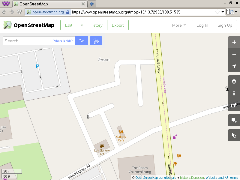
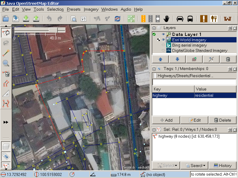
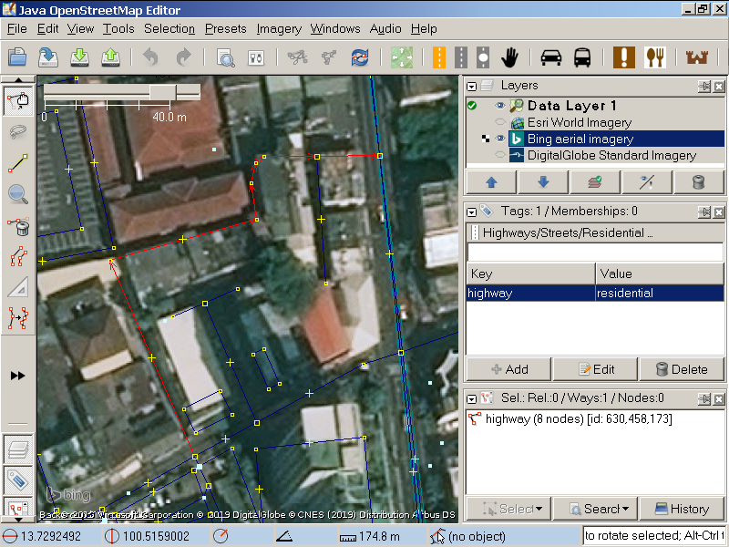
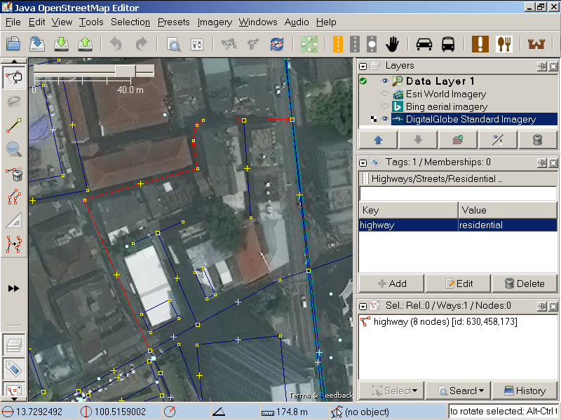
| 63184104 | over 6 years ago | #WhatInGrabsNameIsThis? This whole edit is becoming an epitome of how armchair mapping could go wrong... What about this "residential road" connecting between Captain Bush lane and Charoen Krung road? The so-called "residential road" you mapped:
ESRI overlay:
Bing overlay:
DigitalGlobe Standard overlay:
I have taken trouble to actually check these on the ground and... - Its east entrance cannot be found.
You are misled by imagery, duped by the shadows. Without actual survey to back things up, your methodology is invalid. This edit is now reverted further in changeset/71893823 <changeset/71893823>. For other reviewers; the correct parts are added with ground survey via: - changeset/71954288 <changeset/71954288>
This is what it really is, as far as ground-based observation can gather:
|
| 66596470 | over 6 years ago | Only valid justification for dividing road like this is for tagging them differently, or for adding them to different relations. Otherwise, you are just messing with object's history, and taking other people's credits. Please read <osm.wiki/One_feature,_one_OSM_element>. This changeset is now reverted on the Si Phraya road part, via changeset/71889180 <changeset/71889180>; which I have verified personally that there's no lane configuration change for the entire range. #GrabWTF |
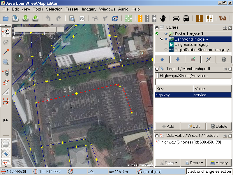
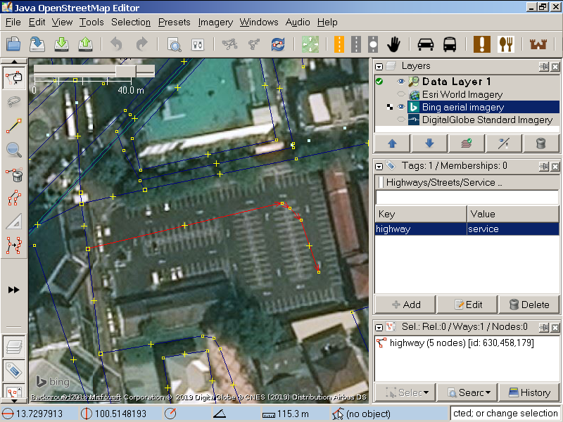
| 63184104 | over 6 years ago | #WhatInGrabsNameIsThis? A crooked "service driveway" branching from Captain Bush lane... that goes through a *fence*? And into where exactly? What you mapped:
ESRI overlay:
Bing overlay:
DigitalGlobe Standard overlay:
Apart from not surveying the damn thing; out of all imagery, you chose the one most outdated on as possible. And forget cross-checking 'cause that's obviously too much to ask from a *paid* corporate armchair mapper... This rubbish is now reverted, again, in changeset #71822438 <changeset/71822438>. For other reviewers, this is what it actually is:
|
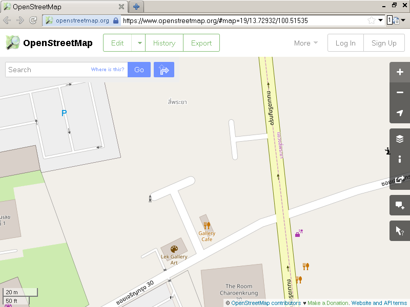
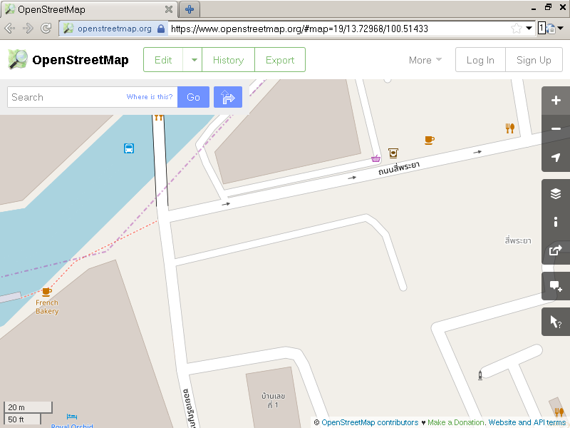
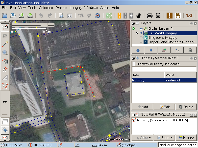
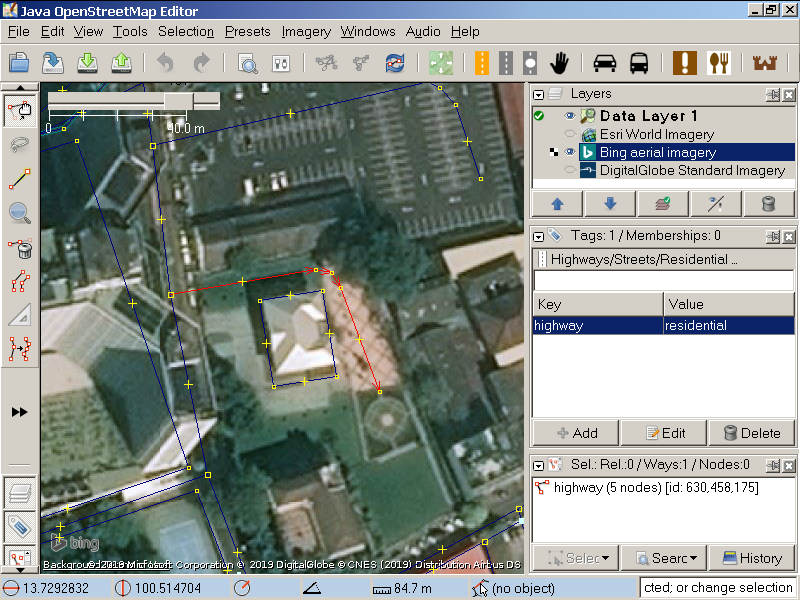
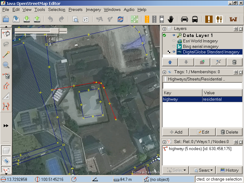
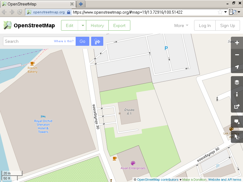
| 63184104 | over 6 years ago | #WhatInGrabsNameIsThis? House Number 1 doesn't have any driveway curving around on its north side. I wonder how did you came up with this rubbish anyway... What you mapped:
ESRI overlay:
Bing overlay:
DigitalGlobe Standard overlay:
So, you just marked anything you saw on Digial Globe Standard as narrow and "gray" as *residential* street, without even bother to cross-check against ESRI, or even Bing? That's really crude even for an armchair mapper; and your company said you were going to "improve" OSM? How hypocritical. This part of the changeset is now reverted in changeset/71822150 <changeset/71822150>. For other reviewers, this is what it actually is:
|
| 59924394 | over 6 years ago | The rest of this edit has been reverted in changeset/71813577 <changeset/71813577>. I have personally verified that there is no bus stop anywhere near the north side of Surawong junction; at least until one walked northward beyond the General Post Office <node/6276433488>. |