OpenStreetMap logo OpenStreetMap

Users' Diaries

Recent diary entries

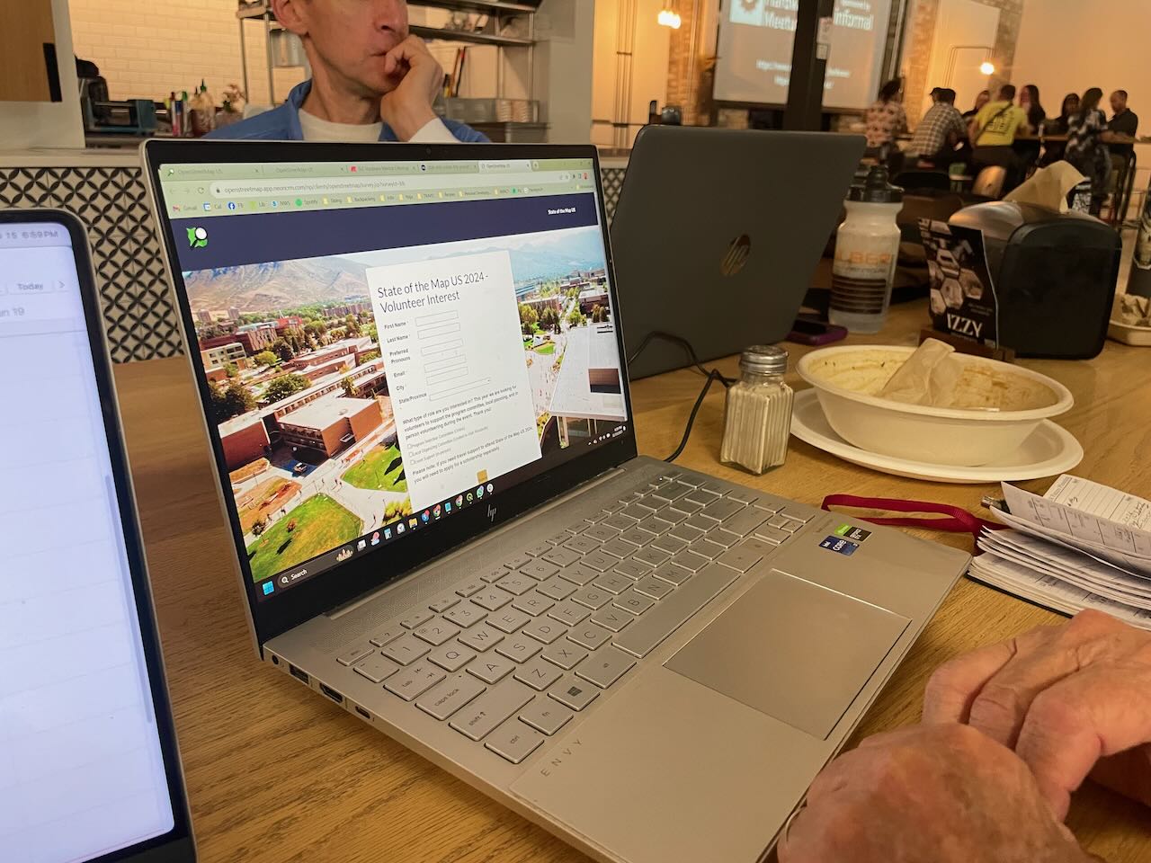
I organize the OpenStreetMap Salt Lake City monthly meetups. I don’t usually write reports on the individual meetups, but I had even more fun than usual last night so I thought I would write a quick report!

We had a great evening (as always) and with a good turnout too! We talked about SOTM US 2024, to be hosted in our fine city next June, and everyone signed up as a candidate volunteer for the event!

people signing up as volunteers

We also shared some knowledge about drones and related software; I know next to nothing about drones and haven’t kept up with the technology, so that was really interesting to me. We may pursue a small grant to acquire one for our OSM group. I am not sure from where yet.

As usual, we discussed recent business openings and closings to keep the map up to date. We have good resources like Gastronomic SLC (a weekly newsletter and website with news about restaurants and bars in the area) and City Weekly, a local newspaper, and of course our own observations.

See full entry

Location: Granary District, Salt Lake City, Salt Lake County, Utah, United States
Posted by SimonPoole on 15 November 2023 in English.

Way back in 2015 I wrote this diary post Is OSM business unfriendly? on how core OSM limiting itself to data collection had fostered a bustling ecosystem.

Organisations from small to large, commercial and non-commercial have built their businesses on building OSM know-how, normalizing the data, aggregating it with other sources, and providing services on top of it. It is one of the major factors that has made OSM not just a hobby project, but a notable player on the global stage.

Yes, the Linux Foundations OMF is disruptive, but the disruption is mainly in that it will remove a major part of the raison d’être for these organisation in the wider OSMspace.

The surprising bit at SOTM-EU over the weekend was just how hilariously unaware both Linux Foundation members and representatives were that their main effect will be stomping out a whole raft of SMEs, and the sudden realisation by the victims that US big tech and their non-profit front are not their friends.

What does this mean for core OSM?

I’ve argued that we should be moving the boundary of what we do outwards so that we can at least provide more of what was provided by the layer of service providers. Not all of the market for geo data and services outside of the US tech bubble is going to enthusiastically embrace that their choice of suppliers has been reduced to a duopoly. But I will concede that doing nothing and letting the market forces play out is the more OSMish reaction.

PS: I would point out that all of the above has already chewed though multiple times in public. Maybe if the Linux Foundation doesn’t want to be put on the spot and look very very out of touch they should read what other people are saying about them.

Всем привет кого давно не видел)

Возраст первой (уцелевшей) правки в разных местах. First Edit age

Удивительны две вещи: 1) Импорт Тайгера в США до сих пор виден. 2) еще можно отыскать место, в котором данных нет и сделать первую правку.

Ну и до кучи средний возраст объектов.

See full entry

So the SotM EU just ended (guys from UK asked to call it “Europe”, not “EU”). We had a lot of talks, hundred people from the States and Belgium, met many friends. And also learned a bit more about Overture Maps. Nothing new since my Shtosm post, but updates my post about donating money. This is a rough DeepL translation of this and this telegram posts.

Marc’s Address

First, a simple one. Overture is not OpenStreetMap. Marc started by saying that the target audience for Overture Maps is developers. Just as Ballmer once chanted: developers, developers! And he’s right: Overture makes working with data much easier for developers. The data is collected, cleaned, in a convenient format, take it and build it into the product.

So the audience is product developers. Who know little about geo, but a lot about building products. As I wrote in the reddit about VLC, there are developers and there are developers. The audience here are opensource developers: god knows how to organize them. They are not the TA of Overture. They’re doing OSM. So when Mark encourages developers to use (and of course improve) Overture here, he’s kind of leading developers away from OSM. And that’s the first thing that was a bit tone deaf in his presentation.

The second is what I detailed in my question after the talk. That is, I’ve written before that Overture is an awesome wrapper to OSM. It sells data, it sells an idea, it does all the things we don’t want to do. But at the same time, the attitude towards Overture and the community was: you’re doing a great job, all these maps are very good, the tools you’ve written are great too, keep it up.

See full entry

Posted by unsungNovelty on 14 November 2023 in English.

OpenStreetMap (OSM) is fun and fantastic for so many reasons. One being able to roam around the world from the comfort of your chair. I started mapping on OpenStreetMap in 2015 by coincidence through a friend. And OSM later became part of my work at Mapbox. Where I went through out the world as an armchair mapper. I used to maintain a list of interesting places as I encountered them. Then map it later when I am free. Here are my 3 memorable OpenStreetMap edits.

Valparai, Tamil Nadu, India

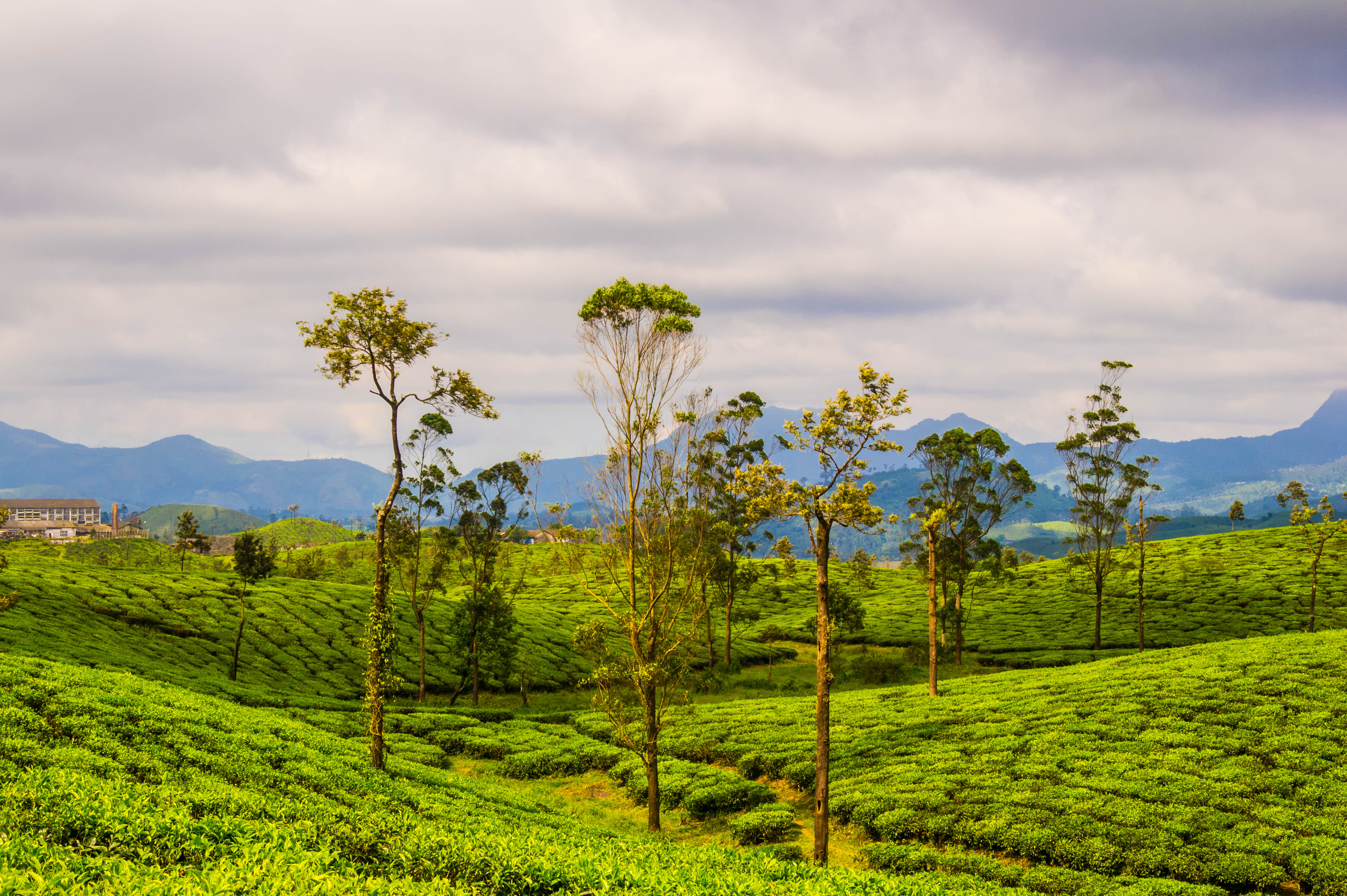
Tea plantations in Valparai by Thangaraj Kumaravel | Image license: CC BY 2.0 Deed

See full entry

Posted by gregorywpower on 13 November 2023 in English.

Mapping Cary’s Downtown Park

First Contribution

This was my first attempt at trying to map out a public park from the original CAD drawings attempting to draw out this map by hand using JOSM. If there’s a way that I could trace polygons from QGIS and be able to save them, I’ll probably end up trying to go that route.

What I Learned

  1. AutoCAD files aren’t always geocoded
  2. GeoParquet files are your friend
  3. Geodatabases are your best friend
  4. Don’t trust Aerial Imagery, field surveys
Location: Cary, Wake County, North Carolina, United States

Let’s take a look at addition and division mapping of natural and landuse. First we will look at the inconveniences that exist when mapping such areas. Next we will look at the method behind division mapping and scenarios of how to apply it. And finally take a real world example of how these two mapping styles were applied.

The definition of addition mapping is the act of adding new data to a white spot area aka an area with no data.

The definition of division mapping is the act of taking an existing object and dividing it down into smaller partitions.

Inconveniences when mapping natural and landuse

There are two main inconveniences when mapping natural and landuse from aerial imagery. First, depending on the resolution of the imagery, deciding where to make a clear cut if it is a distinct natural or landuse area. And second, the amount of clicking required to create a new area.

For the first inconvenience, more or less, it is personal choice and level of details. E.g. try to answer this question: when would one make a distinction between natural = scrub and natural = wood? The difficulty exists in the fact that the value scrub permits trees and lots of time these trees are/aren’t growing close enough to each other.

For the second inconvenience, lots of editors have the option to split a way (aka division mapping). In JOSM you can split an area with ALT+X (UtilsPlugin2 required). Or manually split the circumference of an area at two nodes and then separately connect the two arcs.

UtilsPlugin2 - Split Object tool

Let’s say one needed to create 4 square farmlands in a grid layout. How many node clicks are required?

Mapping the traditional way (aka addition mapping) 16 node clicks are required. One square has 4 nodes, and there are 4 squares, so 4 * 4 = 16.

Mapping with UtilsPlugin2, it takes 8-10 node clicks. There are two methods to achieve this. The first step is equivalent for both methods by drawing the circumference which is 4 node clicks.

Method 1

See full entry

Location: Bencetići, Mjesni odbor Mrzljaki - Goljak, Draganić, Municipality of Draganić, Karlovac County, 47201, Croatia

We use the data from OpenStreetMap while hiking through Colombia, Panama and Peru. It is really solid and a big thanks you to all the contributors!

One thing always stands out though. Almost all of the local people have never heard of the name ‘OpenStreetMap’. However, whenever we get information about trails they ask if we use Maps.me or recommend using it. For those that don’t know, Maps.me is simply an app showing data from OpenSteetMap!

We’re not sure why Maps.me is such a popular recommendation, though the name may be easier to remember that OpenStreetMap. We think it may simply have been one of the first apps that was free and allowed you to easily download maps for offline use?

We use an app called Organic Maps ourselves and can recommend it to anyone that goes hiking in another country. It is a privacy-friendly app and we found out it even preloads data from Wikipedia (for instance on towns, soms highlights/attractions and mountain tops).

Posted by Raquel Dezidério Souto on 12 November 2023 in Brazilian Portuguese (Português do Brasil). Last updated on 20 November 2023.

IVIDES.org promoverá o GIS DAY 2023, como parte da iniciativa global #osmgeoweek, the OpenStreetMap Awareness Week. O Instituto IVIDES.org conta com a colaboração do HUB YouthMappers Rio de Janeiro, que inclui um poll de universidades brasileiras - UFRJ, UERJ e UFRRJ. A responsável pelo evento é a Dra. Raquel Dezidério Souto - [email protected].

banner

As atividades programadas - palestras especiais, mapatonas e validatonas, serão promovidas para melhorar a completude dos dados no Estado do Rio de Janeiro (Brasil), uma contribuição para a redução de riscos e desastres em cidades selecionadas (nesta primeira fase do projeto) - Maricá, capital Rio de Janeiro (Mosaico das Vargens, Recreio dos Bandeirantes) e Seropédica.

Informações em:

https://ivides.org/hub-youthmappers-rio-de-janeiro-brasil

Palavras-chave: OpenStreetMap, IVIDES.org, HUB YouthMappers Rio de Janeiro, Brasil, mapeamento colaborativo.

See full entry

IVIDES.org will promote the GIS DAY 2023, as part of the global initiative #osmgeoweek, the OpenStreetMap Awareness Week. The Institute IVIDES.org has the colaboration of the HUB YouthMappers Rio de Janeiro, that includes a poll of Brazilian Universities - UFRJ, UERJ and UFRRJ. The promoter and responsible of this event is Dr. Raquel Dezidério Souto - [email protected] (IVIDES.org).

banner

The scheduled activities - special keynotes, mapathons and validatons will be promoted to improve data completeness in the State of Rio de Janeiro (Brazil), a contribution to the reduction of risks and disasters in selected cities (at this first stage of the project) - Maricá, Rio de Janeiro (Mosaico das Vargens, Recreio dos Bandeirantes) and Seropédica.

The event is open to all and the subscriptions can be done at this direction: https://encurtador.com.br/knEFJ

Wellcome to Rio! Wellcome to OpenStreetMap and the free and open software comunity!

See full entry

EVENTO - 14 e 15 de Novembro de 2023 - GISDAY AMAZÔNIA 2023 🌿🌍

Semana de Conscientização Geográfica

EVENT November 14th and 15th, 2023 - GISDAY AMAZÔNIA 2023 🌿🌍

Geographic Awareness Week

Participe deste evento incrível e explore o poder da geoinformação na Amazônia!

📆 DATA: 14/11/23 - Presencial na UEPA/NUPAD/LEGA 15/11/23 - Híbrido - Online

🕘 HORÁRIO: 09:00 às 18:00

🤝 ORGANIZAÇÃO: LEGA (Laboratório de Estudos e Pesquisas Geoambientais da Amazônia) - UEPA

🤝 PARCERIA: Meninas das Geotecnologias - IFPA

🌟 APOIO: Esri, UmbraOSM, Youthmappers

✅ INSCRIÇÕES ABERTAS em https://doity.com.br/gisday-amazonia-2023

Não perca! Este evento é uma oportunidade única para aprender, colaborar e descobrir como a tecnologia geoespacial está moldando o futuro da Amazônia. Junte-se a nós e seja parte dessa jornada rumo à conscientização geográfica! 🌎🌿 #GisDayAmazônia2023 #Geoinformação #PreservaçãoAmbiental

See full entry

Location: Cremação, Guamá, Belém, Região Geográfica Imediata de Belém, Região Geográfica Intermediária de Belém, Pará, North Region, Brazil

A V Olimpíada Brasileira de Cartografia - OBRAC 2023 incluiu o OpenStreetMap como parte da sua segunda etapa, de natureza prática. As equipes participantes, compostas de professores e alunos (de 14 a 18 anos), de escolas públicas e privadas e de todo o País, mapearam aspectos ambientais e socioeconômicos de áreas selecionadas da Região Amazônica brasileira, utilizando editores on-line e aplicativos para mapeamento com o OpenStreetMap.

Exposição Amazônia no Mapa

A Dra. Raquel Dezidério Souto (IVIDES.org e UFRJ), que coordenou a parte técnica desta segunda etapa da competição, criou a exposição virtual Amazônia no Mapa, com parte dos mapas elaborados pelas equipes participantes.

expo_banner 
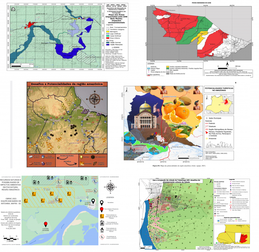
Fonte: equipes participantes da OBRAC 2023 - Ref. 6298800859 (topo esq.); 6299051019 (topo dir.); 6116334695 (centro esq.); 6474822799 (centro dir.); 6169070179 (inf. dir.); 6191786719 (inf. esq.).

OBRAC

See full entry

The V Brazilian Cartographic Olympiad - OBRAC 2023 included OpenStreetMap as part of its second stage. The participating teams, integrated by teachers and students (aged between 14 and 18 years) from public and private schools, from all over the country, mapped environmental and socioeconomic aspects of selected areas of the Brazilian Amazon Region, using online editors and applications for mapping with OpenStreetMap.

Exposition Amazônia no Mapa

Dr. Raquel Dezidério Souto (IVIDES.org and UFRJ), who coordinated the technical part of the second stage of the 2023 edition, created a virtual exhibition Amazônia no Mapa, where anyone can visit the maps of the Brazilian Amazon Region, created by the teams of the OBRAC 2023.

expo_banner Source: OBRAC 2023 Teams - Ref. 6298800859 (topo esq.); 6299051019 (topo dir.); 6116334695 (centro esq.); 6474822799 (centro dir.); 6169070179 (inf. dir.); 6191786719 (inf. esq.).

OBRAC

See full entry