.
Users' Diaries
Recent diary entries

1.1
Posted by DavidKarlas on 9 November 2023 in English.
Tampermonkey is web browser extension that allows adding JavaScript to any website in your browser and manipulate content of that website. It sounds scary and probably should, first you need to trust extension itself and then scripts that you install. Since extension itself has huge community and history, millions of installs across Chrome/Edge/Firefox extensions stores, 5 stars… Let’s assume we can trust it…
I wrote some time ago script that I want to share with everyone, it adds few buttons to OpenStreetMap.org website.
Here is example how it looks like:

On example of New York above buttons would take you to following websites:
- PeWu nice and simple history view of changes on nodes, ways or relations
- DeepHistory another history viewer, but in tabular view
- Relation Analyzer helpful website for validating/analyzing relations
- Overpass Opens Overpass at same viewport as currently seen on OSM website

-
Do you like to write descriptions for edits? And review other people’s edits if there is an unclear comment? Autogeneration of descriptions like in MAPS.ME and EveryDoor is interesting. But why not make ChatGPT do it?
-
ChatGPT is already pretty good at recognising pictures.
 And we have thousands of open notes from StreetComplete with signs of establishments. It would be nice to add tags to the object in a couple of clicks that ChatGPT could recognize. Or build this function directly into some editor.
What kind of work would you put AI to?
Greetings to all OSM contributors, I have finally found some time to share my mapping party report. I wrote it in English and French. This mapping party was held in France near Grenoble, in a village called Saint-Barthélemy-de-Séchilienne. There were 8 of us who participated in this mapping event.
For the report, I wrote some scripts: a bash script that uses the osmosis command to extract the following metrics like : number of roads, tracks, roads with names, alleys, shops, libraries, buildings, …, see the full list in the report.
The idea of this script was to download the data of the city/village before the mapping party and run the script on the resulting osm file. Then, do the same after the mapping party to see how many objects were added. Info about my script can be found here
Bhagwal is a village in Tehsil Kharian District Gujrat Punjab Province Pakistan 🇵🇰
Trying to add detail to the areas around Lower Mast Landing Road, Upper Mast Landing Road, and Bow Street.
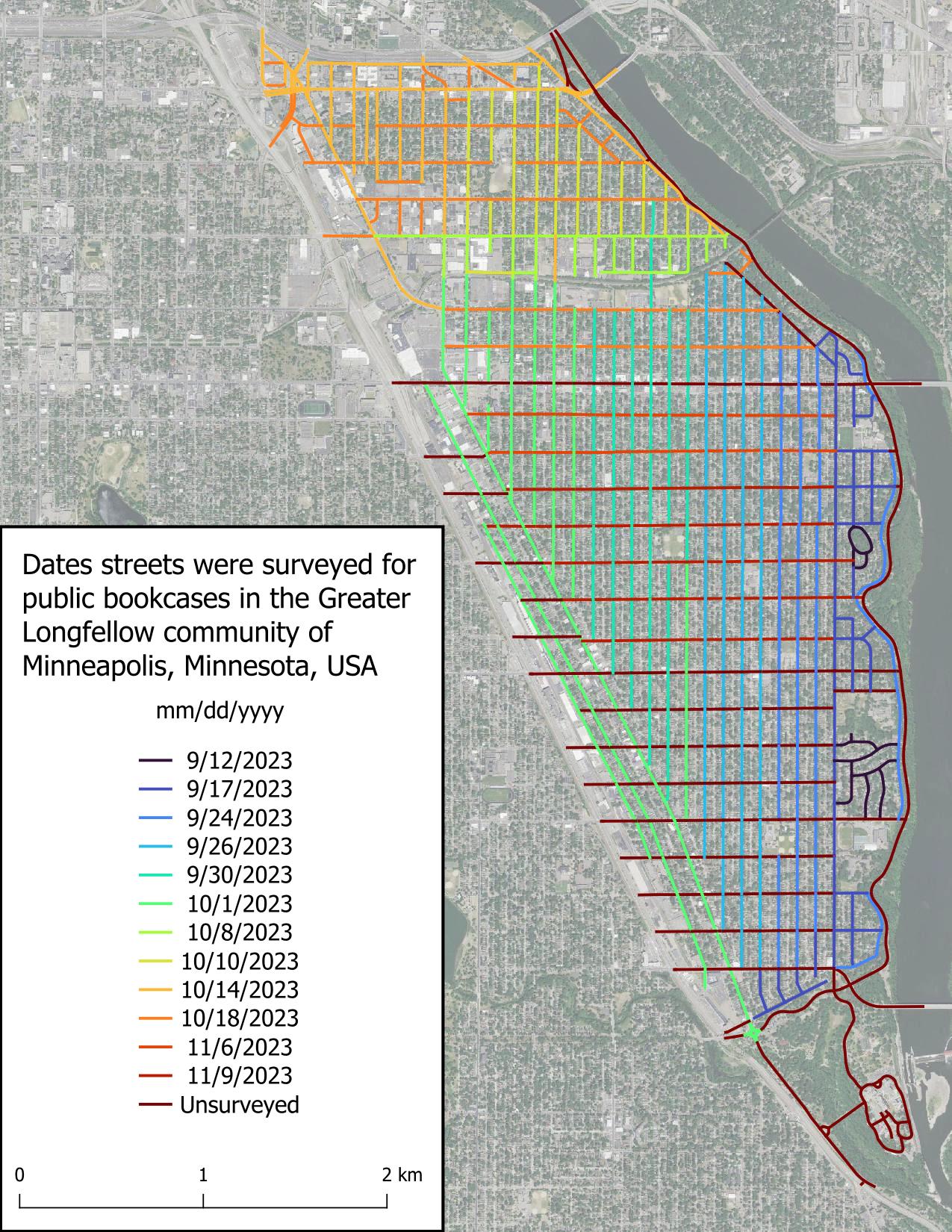
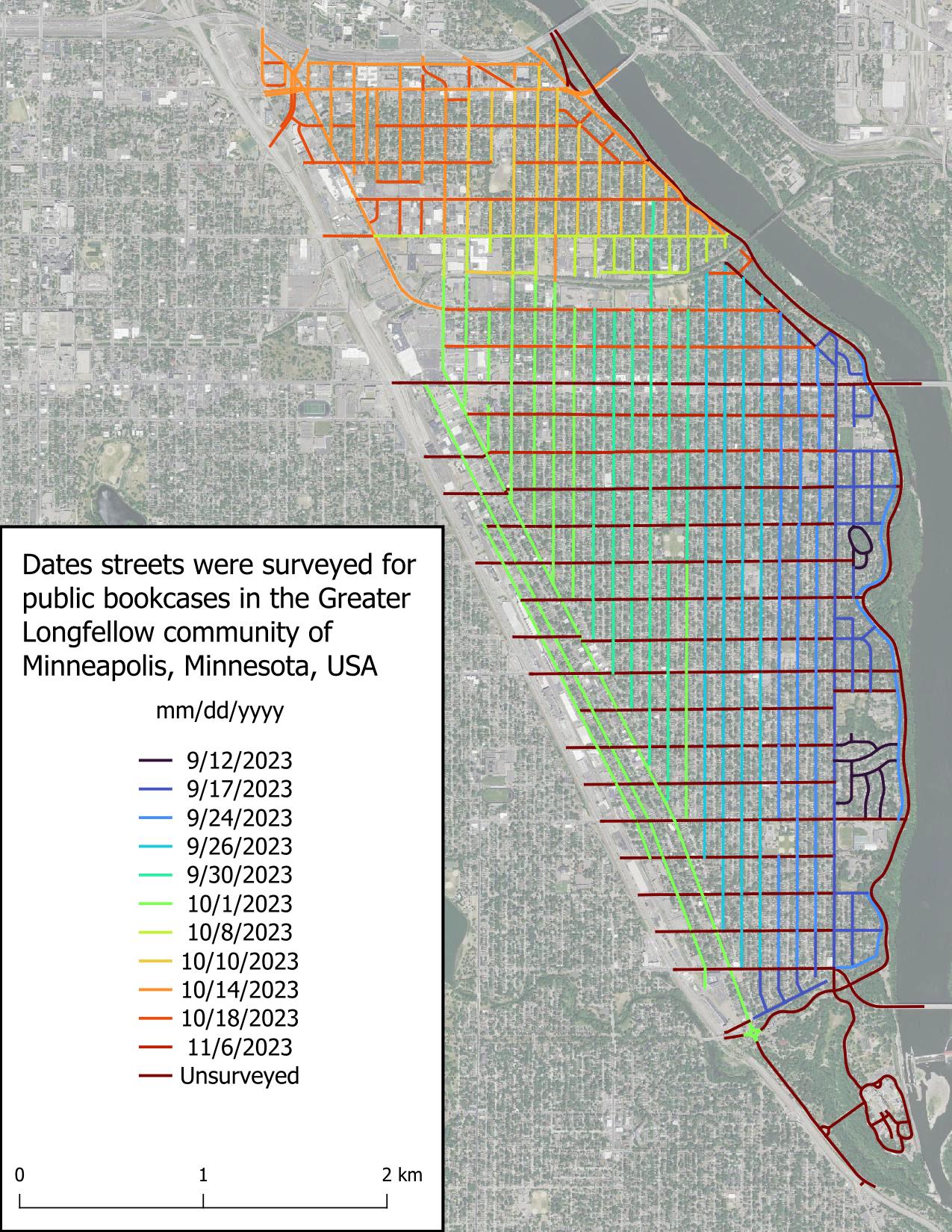
It is now cold out and also dark, which bodes poorly for finishing this project in a timely manner, because biking when it’s cold and dark isn’t fun. I was not able to achieve my goal of finishing this project by first snowfall (we got 1.8 in [4.6 cm] on Oct 31), but I’m not taking this to heart because a lot of my time the past several weeks has been spent with higher priority things.
Today I was able to finish two streets in about 30 minutes, which is great! These were some of the longer streets in Greater Longfellow, so the pace will be quicker from here on out, most likely due to there being less clutter obstructing my view.
I’ve found it very enjoyable to record and upload GPS traces as I do various activities. These can help with assessing imagery offsets, route accessibility and popularity, adding brand new routes, and as a refresher after I get back from a walk, hike, bike ride, or drive. Here are some questions, issues, etc. I’ve been thinking about. Feel free to comment on any or all:
No.
I have been checking all Danish motorway,trunk,primary,secondary, and tertiary roads without a maxspeed tag using geotagged photos (Mapillary, Kartaview, Bing). The maxspeed status now is (distances in km):
Maxspeed stats
- motorway :: missing maxspeed: 0 , total: 2586 , pct with maxspeed: 100.0
- trunk :: missing maxspeed: 0 , total: 502 , pct with maxspeed: 100.0
- primary :: missing maxspeed: 0 , total: 2771 , pct with maxspeed: 100.0
- secondary :: missing maxspeed: 10 , total: 6531 , pct with maxspeed: 99.85
- tertiary :: missing maxspeed: 5421 , total: 23739 , pct with maxspeed: 77.16
- unclassified :: missing maxspeed: 24821 , total: 32060 , pct with maxspeed: 22.58
- residential :: missing maxspeed: 20866 , total: 27987 , pct with maxspeed: 25.45
I believe this is really good. Most routing decision will have almost optimal data. Even if the first or last part of potential routes are short residential or unclassified ways with unknown maxspeeds, it will in most cases not affect the result because there are no alternatives.
Motor-vehicle users of OpenStreetMap apps will most of the time be on roads with known max-speeds. I know this because it is getting quite difficult for me to get to ways without maxspeed to produce geotagged photos. I download a GPX file with ways without maxspeed to OsmAnd so that I can try to photograph them if it not too much out of the way.
Quality
Of course having maxspeed tagged on many roads is only valuable if the tagging is correct. I did find some incorrectly tagged max-speeds. This was mainly due to:

Después de haber participado en el evento de Wikimedia Colombia, me interesé aún más en apoyar la integración de estos proyectos, sabiendo que ya hay varias formas, pero no son muy conocidas. Por eso, aquí voy a listar las cosas que conozco, y actualizaré la entrada cuando encuentre más.
Etiquetas en OpenStreetMap
- Etiqueta wikipedia - Key:wikipedia
- Aquí se puede ver que en muchos casos no se debe usar solo esa etiqueta, sino acompañada de:
- artist:wikipedia
- architect:wikipedia
- brand:wikipedia
- subject:wikipedia - Probablemente la más común.
- operator:wikipedia
- network:wikipedia
- species:wikipedia
- taxon:wikipedia
- name:etymology:wikipedia
- Aquí se puede ver que en muchos casos no se debe usar solo esa etiqueta, sino acompañada de:
- Etiqueta wikidata - Key:wikidata
- Para asociar ese concepto de wikidata en OSM.
- Tiene muchas etiquetas secundarias:
- architect:wikidata
- brand:wikidata
- buried:wikidata
- flag:wikidata
- genus:wikidata
- manufacturer:wikidata
- model:wikidata
- name:etymology:wikidata
- network:wikidata
- operator:wikidata
- owner:wikidata
- royal_cypher:wikidata
- species:wikidata
- subject:wikidata
- taxon:wikidata
Atributos de Wikidata
- coordinate location - P625
- Al abrir el wikidata, se verá un mapa de OpenStreetMap con la ubicación.
- headquarters location - P159
- Muestra el lugar de la casa matriz en un mapa.
- OpenStreetMap relation Id - P402
Herramientas de edición
as of November 2nd 2023 I have begun work on adding the forest areas in the town of Freeport, Maine 04032
Posted by AgusQui on 3 November 2023 in Spanish (Español).
Memoria descriptiva del mapeo de señales y carteles, usados por los trenes en la sección eléctrica de la Línea Sarmiento (Once-Moreno).
No encontré manual de señales para ésta línea, no soy experto ferroviario, no tenía idea de señales ferroviarias hasta que empecé a investigar para mapearlas en ésta línea, que es la que uso habitualmente, todo lo descripto aquí es en base a investigación en manuales de otras líneas y cosas que encontré por ahí, no estoy seguro de algunas cosas, funciones y sus nombres, por lo que por favor: corrígeme! Se dejan anotados los tags que se usan en ésta línea, pero se mencionan otros por si te sirve para mapear en otro lugar, revisar la wiki para más etiquetas.
Las señales son del tipo “semáforo” o de aspectos lumínicos, entre Once y Liniers las señales principales tienen 4 aspectos, entre Liniers y Moreno tienen 3.
Es común ver en un mismo poste varias señales, cada señal tiene su propio código de referencia, por lo que tuve que generar un nuevo tag para esto, https://wiki.openstreetmap.org/wiki/Key:railway:signal:main:ref, https://wiki.openstreetmap.org/wiki/Key:railway:signal:route:ref, https://wiki.openstreetmap.org/wiki/Key:railway:signal:shunting:ref, si hay una única señal se usa https://wiki.openstreetmap.org/wiki/Key:ref.
Hey! Just testing out this diary feature.
I’m making a diary entry as I’ve just seen this feature, I assume this will be shown on my profile. I see we can also include a location to it! Should a diary entry be tied to a specific location? Writing this, I start to wonder…
- Do people use this feature at all? If so, for what?
- How do people find this? I’d assume it is not every mapper’s pastime to casually stalk other mappers’ profiles! Am I wrong?
- Are there mechanisms that allow you to discover local users?
- Do some people use the platform as a mean to meaningfully connect and perhaps extend connections to other projects or platforms?
- Are relations rather equal between users, as in Facebook, where friends are friends with each other and where exchanges are expected to be mutual or is there power distance between users, like on Instagram, with followers and the followed?
Perhaps I’ll make a new diary entry when I’ve found out! :p
mapping workshop for beginners on Openstreetmap
Oficina de mapeamento para iniciantes no Openstreetmap
Inscrições Abertas! Inscrição na Oficina de Mapeamento

Inscrições Abertas!
Inscrição na Oficina de Mapeamento
The Mapping of the Marco Neighborhood, Belém - Pará - Brazil will be done by Beginners and Advanced Mappers and aims to Include Buildings, Points of Interest (General Commerce, Schools, Health Centers and Squares) thus improving data from the City of Belém.
https://tasks.hotosm.org/projects/15707
Workshop created by umbraosm
UMBRAOSM - Union of Brazilian Openstreetmap mappers www.umbraosm.com.br
Posted by umbraosmbr on 1 November 2023 in English.
project activated by UMBRAOSM 2023/2024 edition
 ##01/11/2023 - project activated by UMBRAOSM
Union of Brazilian Openstreetmap mappers
##01/11/2023 - project activated by UMBRAOSM
Union of Brazilian Openstreetmap mappers
BRASIL - BAIRRO MARCO - BELÉM- (PA) - EDIFÍCIOS, PONTOS DE INTERESSE E ÁREA VERDE.
https://tasks.hotosm.org/projects/15707
O Mapeamento do Bairro Marco, Belém - Pará - Brasil será feito por Mapeadores Iniciantes e Avançados e tem como objetivo Incluir Edifícios, Pontos de Interesse (Comercio em Geral, Escolas, Postos de Saúde e Praças) melhorando assim os dados da Cidade de Belém.
The Mapping of the Marco Neighborhood, Belém - Pará - Brazil will be done by Beginners and Advanced Mappers and aims to Include Buildings, Points of Interest (General Commerce, Schools, Health Centers and Squares) thus improving data from the City of Belém.
BRASIL - BAIRRO MARCO - BELÉM- (PA) - EDIFÍCIOS, PONTOS DE INTERESSE E ÁREA VERDE.
https://tasks.hotosm.org/projects/15707
Link do Projeto: https://www.umbraosm.com.br/mapeia-belem.html
Posted by umbraosmbr on 1 November 2023 in English.