
OSM
Users' Diaries
Recent diary entries
Posted by bkil on 21 November 2022 in Hungarian (Magyar).
Last updated on 8 December 2022.
Részletek / details: https://wiki.osm.org/Hungary/20221209
Tortával jutalmazzuk a szabad platformunkon jelentkező első 20 tagot: OSM wiki, OsmCal, GetTogether, Mobilizon, Friendica-Mastodon, levlista.
Cake will be awarded to the first 20 members who RSVP on one of our open platforms: OSM wiki, OsmCal, GetTogether, Mobilizon, Friendica-Mastodon, mailing list.

Posted by bkil on 21 November 2022 in Hungarian (Magyar).
Részletek / details: https://wiki.osm.org/Hungary/20221201

Posted by Lab Utopia on 21 November 2022 in Brazilian Portuguese (Português do Brasil).
A partir dos conceitos de sobreposição de camadas depositadas em contextos temporo-espaciais definidos, coleta/registro de histórias de vida e mapeamento colaborativo abordaremos a história regional e a localização/identificação de sítios arqueológicos para subsidiar o desenvolvimento de um mapa histórico/cultural/arqueológico do Litoral do Paraná. A arqueologia, a história dos povos sem história, aborda referenciais teóricos e debates epistêmicos que compõe a disciplina, as práticas de campo trazem os métodos de coleta de experiências de vida, história oral e etnohistória. Arqueologia pré-histórica, histórica, a formação contemporânea de depósitos da cultura material, a história regional, oralidades, relatos de vida e etnografias serão reunidas a partir da vivência de estudantes e do processo de construção de diários de campo com entrevistas e relatos biográficos locais. Todas as informações, georreferenciadas, comporão o Mapa Histórico/Cultural/Arqueológico do Litoral do Paraná.

Vor allem gpx Tracks geladen

“Pontosan mennyi is a sebességhatár? Elfelejtettem!”
Nos ez elég ritkán történik meg, de ha mégis megtörténik, akkor bajban vagyunk. Az OpenStreetMap sok helyen kijelzi a sebességkorlátozást helyesen, de sok helyen pedig elavultak az adatok.
Nincs semmilyen modern megfelelő megoldás a sebességkorlátozások felvitelére az OSM-en. Jelenleg úgy működik, hogy az adott úton címkézni lehet, milyen sebességkorlátozás van. De ha az út mentén változik, az útat több részre kell bontani, ami csak komplikálja a folyamatot, valamint sok térképalkamazás külön útként érzékeli és ezáltal többször is kiírja az út nevét vagy azonosítóját, mint amennyire kellene.
Jogos a kérdés, hogy egyáltalán fel kell-e még vinni a sebességkorlátozásokat? Hisz a legtöbb csak időszakos, és a modern autókban elérhető egy táblafelismerő rendszer, ami emlékezteti a sofőrt a korlátokról.
Posted by Arturo Francisco Barbero on 20 November 2022 in Spanish (Español).

Pilangostillos node/9681203407 Los Poyales node/7249411404 Los Arteseros way/993416059 La Camorca way/791858644 Cítores way/999354903 Las Hijuelas node/9964297554 Las Hijuelas 2 node/9964297553 Chozo Aránguez way/410615253
Posted by renminbo on 19 November 2022 in German (Deutsch).
Last updated on 14 January 2023.
Auf den ersten Blick sieht es im Oktober 2022 so aus, als wäre das Gebiet Vorholz zwischen Alzey und Kirchheimbolanden eine 1a Wandergegend. Wenn man sich dann die Relationen der Wege ansah bekam man Zweifel: Viele Lücken. Und daraus folgend auch Sackgassen, da freut sich der Wanderer.
Ich habe in der VG Alzey-Land angerufen und von einer sehr kompetenten Mitarbeiterin erfahren, dass sich bei der Gemeinde schon der Förster gemeldet hatte, weil er verzweifelte Wanderer im Wald sah, die sich nicht zurechtfanden. Prima. Und dann sagte sie, dass eigentlich alle Wege abgekündigt seien, evtl. könnten einige der NW-Wege bestehen bleiben, die R-Wege und der Kneipp-Napoleon würden eingestellt.
Gerade um den letzteren (K-N) ist es schade, denn der hat schöne Schilder, ist aufwändig gemacht. Er ist fast der Hauptweg im Gebiet. Aber er hat auch viele Sackgassen in der Relation.
Was tut nun der OSM-Mapper? Ich habe für die NW-Wege die Relationen repariert, da war noch eine Karte des Soll-Zustands zu finden. Die R-Wege bekamen das Präfix “Disused”, der K-N wurde etwa zur Hälfte gelassen. Damit ist keine Arbeit endgültig weg, aber die Karten werden von Karteileichen befreit.
Warum keine Reparatur der Relation für R und K-N? Es sind keine Soll-Zustände mehr zu finden, damit müsste die Reparatur die Sackgassen komplett löschen. Damit wird aber eine echte Reparatur immer schwieriger. Oder aber man muss im Feld suchen, wo man noch vollständige Beschilderungen findet, dann geht es. (Letzte Änderung am 14.1.23, die Änderungen an der OSM sind jetzt drin)
اضافه طرق جديده واماكن جديده

The Issue
A common tagging mistake that I’ve encountered a few times is putting the addr:housenumber into the name field. Data of this type tends to be old so it seems the modern tools do a better job keeping this kind of edit from happening. However, when you do find this issue there’s usually a lot of objects to clean up which can be a bother without the right tools.
Finding objects
Here’s the overpass query I’ve used a few times that provides a reasonably stating place:
/*
This has been generated by the overpass-turbo wizard.
The original search was:
“"name"~"^[0-9]" and "building"”
*/
[out:json][timeout:25];
// gather results
(
  // query part for: “name~/^[0-9]/ and building”
  way["name"~"^[0-9]"]["building"]({{bbox}});
  relation["name"~"^[0-9]"]["building"]({{bbox}});
);
// print results
out body;
>;
out skel qt;
Update! User marczoutendijk from the Discord server has provided this overpass query that does a great job finding more instances if this with low noise:
(
  node["name"~"^[0-9]+$"]["addr:housenumber"~"^[0-9]+$"]["brand"!~"."]["shop"!~"."]["amenity"!~"."]["highway"!~"."];
);
The Cleanup
The easiest workflow I’ve found it to load the area into JOSM and run a search with some more specificity. Here’s the search for any building way that has a name tag with numbers at the beginning and doesn’t have an addr:housenumber tag:
name~"^[0-9]+" and building=* and type:way and -"addr:housenumber"Or for names that are up to 3 numbers and nothing more (ex: 7,25,123):
name~"^[0-9]{1,3}" and building=* and type:way and -"addr:housenumber"Or a name that represents a range of housenumbers (ex: 12-16):
name~"^[0-9]+.[0-9]+" and building=* and type:way and -"addr:housenumber"Once you have the right set of objects selected, the tag editior will let you rename the “name” tag to “addr:housenumber”. I like to do a spotcheck or values in the name tag to make sure there’s nothing surprising and then the changes can be uploaded.
Temető itt, temető ott
Helló, kedves térképészek!
Elmúlt halottak napja, mindenki meglátogatta elhunyt szerettei sírját. Ilyenkor, előfordul olyan, hogy nem tudjuk, pontosan hova kell menni, melyik temetőbe. Az sem segít ráadásul, hogy egyes temetők, két település közt helyezkednek el, (jelen esetben Zaláta és Kemse) és filozofálhatunk hosszú perceken át, melyik is az amelyiket mi keressük. Az sem segít, hogy a temetőknek OSM-en nincsenek címei, nem lehet őket a településekhez csatolni, és rengetegnek nincs neve, emiatt igazán megnehezítik a keresést, akár itt, akár az OSM-et használó mobilalkalmazásokban (pl. OSMAnd).
Tapasztalatok
Tehát, a minap, éppen a Zalátai temetőhöz terveztem volna utat, de amikor beírtam az OSMAnd keresőjébe, hogy “Zalátai temető”, semmi. Újrapróbáltam “Zaláta”-n belüli keresés majd a “Temető” szóval. Szintén semmi. Nem volt se name címke csazolva hozzá, címet meg nem is lehet. [Mellékjegyzet: Nagy nehezen odataláltunk.]
A megoldás
Tehetetlenek voltunk, ameddig a Matrix szobánkban, valaki azt javasolta, hogy írjuk be loc_name címkeként a “Zalátai temető” szöveget. Így már az OSMAnd, valamint az osm.org maga is megtalálja, amit kerestem. A loc_name a helyiek megnevezésére egy adott helyre, ahol nincs hivatalos név (name címke), vagy eltér. Egy másik alternatíva azonban az, hogy kérjünk egy funkciót iD-be, hogy legalább a településhez hozzá lehessen csatolni az egyes temetőket.
Frissítés:
Úgy látszik, létezik egy olyan címke, amivel lehet jelölni, hogy az adott terület, mihez tartozik. (Város/falu, stb.) Ez a címke az is_in: is_in=*
Hogy honnan találtam meg? Innen: way/151619056/history
Posted by Not a google employee im a lumberjackie on 18 November 2022 in English.

I do actually map
please don’t ban me
Posted by Provinsi Papua Pengunungan on 18 November 2022 in Indonesian (Bahasa Indonesia).
Last updated on 21 November 2022.
Ibu Kota Tolikara Adalah Karubaga
Posted by Rashid86 on 18 November 2022 in Kazakh (Қазақша).
Last updated on 26 November 2022.

 С 16 по 23 ноября inDrive.Tech проведет кампанию для сообщества OpenStreetMap, приуроченную к Международному дню геоинформационных систем.
В течение недели члены комьюнити и сотрудники компании создадут качественную карту небольших населенных пунктов Казахстана. Приглашаем и вас принять участие в инициативе и внести свой вклад в создание карт! Мы боремся за то, чтобы люди и сообщества всего мира имели равные возможности для развития.
📍 Подробности кампании в (https://t.me/inDriveOSM)
Background
Passionate on earth science and open data and that courage and motive burst my enthusiasm and help me to enroll Bachelors of Geomatics Engineering just after my +2 level. I find this university academic course more interesting than i expected before. Firstly I got to know about the OSM when i was in the first semester of my engineering life through the campus Organization and attend my first ever session on OSM and find it was so interesting. At that time due insufficient network and lack of own knowledge i only start OSM continuing mapping since 2021 but introduced about OSM was since 2019. After engaging so many volunteering work and webinars, mapathons and training sessions, i got chance to do different project at KLL and guidance from the professional mapper helps me a lot to sharp my skills and i am getting more and more interested to mapping.
Later on, I joined Data Quality Intern at HOT from Oct 2022 for 3 months and this is really helping to find better way of controlling data quality and QA tools and so many.
Posted by Not a google employee im a lumberjackie on 17 November 2022 in English.
google_spy
Posted by yvecai on 17 November 2022 in French (Français).
Last updated on 20 November 2022.
This happens on 15.11.2022, somebody mapped the 100’000th kilometer of nordic ski piste.
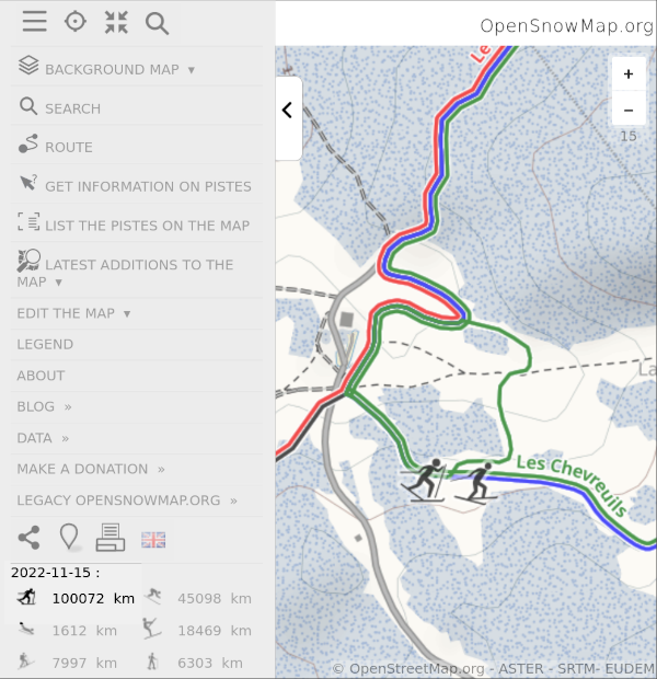 .
.
These are the trails tagged piste:type=nordic. They describe several practices : backcountry touring, classic style on prepared rails or skating on large groomed pistes. In OSM, they are distinguished thanks to the key piste:grooming=backcountry/scooter/classic/skating or classic+skating.
Yves - Opensnowmap.org
Surely, you’ve heard Elon Musk is trying to save / sabotage Twitter (choose the correct answer).
It led a bunch of people to flee from Twitter and discover Mastodon.

Never heard of Matodon ? “Mastodon is free and open-source software for running self-hosted social networking services. It has microblogging features similar to the Twitter service” says Wikipedia.
Amanda from the OSMF is running her own instance called (https://en.osm.town/). She’s looking (threatening?) for a logo.
We need your creativity !
Below, my proposals :
intro testing

Open source culture is increasing day by day in Turkey. In this way, many platforms and associations have been established in the field of open source and data. Many of them organize events, workshops and studies in their field. Websites or social media accounts have been added to reach them. If there is an association, organization or platform you would like to be added to, please get in touch. (It is constantly updated.)

Yer Çizenler Mapping for Everyone
Openstreetmap Türkiye Telegram Channel