فروشگاه لوله و اتصالات و ابزار ساختمانی
Users' Diaries
Recent diary entries
Posted by Andrea Spinelli on 23 July 2022 in English.
During a hike I noticed that a small wooden chapel in a wood in Sudtirol, northern Italy, was placed incorrectly.
I made an exact point (8m precision) with two different apps which average the GPS points; I used 100 points. Latitude/longitude were 46.7138607/12.3411447 , just to be clear; I wanted to move the Kapelle at that position.
However, I found no way of directly entering the coordinates in the description of the point using the ID online editor. I had to resort to trial and error with the openstreetmap standard viewer, repeatedly using right-click/show address to obtain coordinates.
I tried to export data from the apps, but the format was rejected - apparently OSM expects polylines and not single points.
Is there any way to use this detailed information in a direct way?
Thanks in advance to everybody who knows…
Udapte 24 Juli 2022

Hola comunidad de OSM,
El próximo sábado 30 de Julio a las 16:00 UTC se realizará la 4a. reunión bimensual de OSM Latam. El evento se realizará por la plataforma OSM video: https://osmvideo.cloud68.co/user/and-msl-7if-yrk. La agenda de la junta está en: https://wiki.openstreetmap.org/wiki/ES:LatAm/Eventos/20220730_Reuni%C3%B3n_virtual. Todos los miembros de la comunidad Latam están invitados, donde el país organizar presenta sus proyectos, y después se discuten problemáticas a nivel latam.
Como es costumbre, una semana después de la junta bimensual, se realiza una Notathon. Este es un evento en que cerramos notas. En esta ocasión vamos a cerrar notas de Cayambé, Ecuador. El evento se realiza igualmente por OSM video https://osmvideo.cloud68.co/user/and-hrh-m5a-trl y vamos a usar el hashtag #ONL tanto en los commits como en los mensajes en donde cerramos notas. Para más información de la Resolución de Notas, visita la Wiki.
Posted by TrickyFoxy on 23 July 2022 in English.
Last updated on 24 July 2022.

This is an auto-translation of my message from May 8 in the Russian-language OSM chat https://t.me/ruosm/648650
I will try to report some of the following. But now my goal is to say that registration in OSM is something that the already registered participants have forgotten about.
Suppose a person was not afraid and decided to register after all. Next is the real case.
One of the likely situations: a person learns about StreetComplete/EveryDoor and registers through them.
At first, for some reason, he is greeted by a page in English. Well, maybe the problem is in the browser. But why can’t I switch the language on the page?
Well, okay, he thinks, now I quickly register through social networks. Pokes into a conditional Google, gives access and is met by a form in which you need to enter mailS / login / passwordS. What the hell?! For the sake of a login? So just ask him.
Enters the login, password, clicks Register and after refreshing the page finds out that the login is already occupied, the passwords do not match. Enters a new username / password: the login is already there, the password is too weak. But you just need a little JS….
Then there are some agreements that no one reads and.... confirm the email address using the link in the email.
He waits for the letter, pokes at the link and if he still remembers why he did it, returns to the application, logs in and finally decides to upload his changes.
Sadness.
The issue of improving the registration form https://github.com/openstreetmap/openstreetmap-website/issues/3546
upd: Issue to simplify registration via Google https://github.com/openstreetmap/openstreetmap-website/issues/2287
Ticket about simplification of registration. It has been open since 2015! https://github.com/openstreetmap/openstreetmap-website/issues/894
Come in if you also think that registration needs to be simplified 🙏
Posted by renminbo on 22 July 2022 in German (Deutsch).
Last updated on 19 November 2022.
Wo sind die Wege am Donnersberg hin?
Die Karte vom Donnersberg war unübersichtlich, v.a. weil gefühlt die Hälfte der Wege Grade 5 hatten. Aber wenn man dann hinging, waren sie voll mit Totholz, hüfthohem Gras und vor allem überall umgefallene Bäume, die da seit Jahren lagen. Das ist eigentlich nicht, wie Grade 5 sein soll.
Im Wiki wird für solche Fälle das Präfix(!) “Disused” empfohlen/vorgeschrieben, obwohl dadurch die Wege nicht mehr gerendert werden, also verschwinden. Es wird noch die Möglichkeit erwähnt, nur die Mitte auf Disused zu setzen, an den Enden aber noch Schnipsel stehen zu lassen.
Genau das habe ich gemacht, und ich denke, es fällt auf. Es ist aber bei disused das erklärte Ziel, die Daten, die ja noch da sind, nur durch Löschen des Präfix wieder herstellen zu können - Wenn etwa jemand den Weg aufräumt oder der Forst ihn für die Baumernte braucht (dann kommt der ganze Müll blitzartig weg).
Klar, der Gedanke ist etwas politisch. Man kann nun nicht mehr sagen:”Seht doch in die Karte, da sind 200 km Wege überall, was wollte ihr neue, schönere.” Es gibt nämlich gar nicht so viele gute Wege - und das sieht man jetzt.
Oder seht ihr das anders?
re
MTB-Klassifizierung
Die STS-Klassen von 0…5 sind ja gut dokumentiert, sie werden nur oft etwas hoch angesetzt. So gibt es am Rheinsteig eine Stelle (Rossstein), die bestimmt nicht unfahrbar ist, ist mit S4 gekennzeichnet. Das bedeutet für mich Mördergefälle und Riesen-Steine, in Wirklichkeit ist da nur eine Treppe mit Geländer aus Stahlseil. Eigentlich müsste man das auf S2-3 umsetzen. Nur wenn man das macht, kann man sehr viel tun.
Mtb:uphill

Quick recap from this month’s OSM Ireland Map&Chat.
Attendance: 4-5 contributors
Topics
- Sledding hills in Toronto
- Poor law boundaries in Munster (see http://www.dublinhistoricmaps.ie/boundaries/munster/)
- New building projects open on https://tasks.openstreetmap.ie/
- Heritage trees in Ireland
Heritage trees in Ireland
Interesting to learn that the Tree Council of Ireland have a registry of trees and a number of trees have been classified as Heritage Trees. See https://data.gov.ie/dataset/heritage-trees-of-ireland
Brian H. wanted to know how to map these and it turns out there were no entries for heritage= so we fixed that by adding an entry for the Tree Council of Ireland. \o/
New building projects open on https://tasks.openstreetmap.ie/
The existing set of projects were mostly complete so Heikki mentioned that some new projects had been opened up. I started working on Leitrim since I know parts of the county quite well (lived in the neighbouring county of Sligo for a few years). Managed to get some easy tasks completed equating to 2% of the work. :)
Sledding hills in Toronto
Rob had a query about how to map a mound in Toronto he had seen. We concluded that man_made=mound was probably acceptable (some existing usage) but it turned out to be a sledding hill!! While there is no definitive tagging for these, we concluded that the tagging documented for Piste Maps is probably the best fit.
At the OSM Ireland Map&Chat in May 2022, a query arose about how to create maps for specific topics (one of the Irish contributors wanted to callout some memorial benches in their local area).
As a result of the discussion, I created a umap project to demonstrate some of the possibilities:
https://umap.openstreetmap.fr/en/map/kerry-pike-gaa-memorial-benches_765585#18/51.91009/-8.56102
The overpass api query that is plugged into the “Remote Data” url field is:
https://overpass-api.de/api/interpreter?data=[out:json][timeout:25];(node[%22amenity%22=%22bench%22](51.909338348825024,-8.562796711921692,51.9115654863502,-8.5586017370224);%20way[%22amenity%22=%22bench%22](51.909338348825024,-8.562796711921692,51.9115654863502,-8.5586017370224););out%20body;%3E;out%20skel%20qt;
Note: can actually be simplified since we know all the results will be nodes (above has nodes and ways. An exercise for the reader…
Overpass Turbo also has the ability to do something similar (limited control over display format though):
Overpass Query (with MapCSS): https://overpass-turbo.eu/s/1iBL
Interactive Overpass Turbo map: click here
For those looking to understand MapCSS a bit more, see osm.wiki/Overpass_turbo/MapCSS#Color_Coding

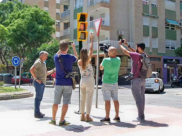 Semáforo conmemorativo dedicado al humorista malagueño Chiquito de la Calzada en el barrio de Huelin. Fuente: trabajo propio (CC BY-SA 4.0) disponible en Wikimedia Commons.
Esta mañana han inaugurado en Málaga un semáforo conmemorativo dedicado a Chiquito de la Calzada. El humorista malagueño ya tiene en la ciudad un parque a su nombre (ubicación), una estatua de bronce y una placa conmemorativa. Sin embargo, diría que ha sido este fistro de semáforo el que más expectación ha suscitado.
Se trata de un semáforo meramente ornamental, sin funciones de regulación del tráfico. Se encuentra en una zona peatonal en el cruce entre la calle Tomás Echeverría y la calle Antonio Soler (ubicación). Tiene un pulsador que al accionarlo reproduce frases del humorista mientras las luces del semáforo se iluminan con gestos corporales propios de Chiquito.

After my last State of the Map talk, some asked me where’s that “Edit Tags” button on the osm.org website, to quickly fix any tags without launching Level0? Of course there wasn’t one: I just quickly made up a text area with Firefox developer tools. But the idea was there.
Now I’m proud to show you that the button works, with a series of changesets to prove it. Alas, not in the website itself: to enable it, you must install a browser extension. Get yours for Firefox or for Chrome. After installing, open the iD editor once, and then look at any object page on osm.org.
This extension is a hack. It uses some undocumented things and will break when something changes in the code. Like, you need to first open iD editor for the authentication to work. If you don’t see the “Edit Tags” link, refresh the page. It is flimsy, but you can edit the map with it.
ماشینکاری حنائی نژاد تراش CNC و فرز منوال

Bamberg zaubert
Auftrittsflächen

Увидел карту https://www.openhistoricalmap.org
и не смог понять как она работает , наверное много баз данных по числу годов , каждая база рез ботов берёт в викидаты , скрины и переводит по локальным местам . Работает медленно ,наверное надоть установить локальный сервер с зеркалом .
Hi mappers! I have been on holiday near Como Lakes for the last few days. I visited the Forte Montecchio Nord, an old WW1 Fort really well preserved.
I like fortifications and I decided to re-map it, because the old work was fairly approximate. I also add a lot of information (contacts, opening hours…), that’s the result:
Before

After
Posted by ivanbranco on 19 July 2022 in Italian (Italiano).
Last updated on 28 May 2025.
Alcuni dei progetti che porto avanti:
- Completare il tagging name:etymology di tutte le strade della città di Vercelli: 77% (Update: 2022-07-22)
- Aggiungere e uniformare tagging Big Benches: 57% (151 su 236)
- Aggiungere wikidata=* o wikimedia_commons=* a tutti gli historic=memorial/monument della città di Vercelli: 85% (mancanti 22 su 184) (Update: 2025-05-28)
- Aggiornamento vecchi nodi con tag della città di Vercelli: 13252 con data media 03 ottobre 2018 (Update: 2023-04-29)
- Pulizia comments=#tomapping2018: 100% ✅
- Pulizia duplicati ref:mise: 100% ✅
- Pulizia duplicati ref:msal: 100% ✅
MapRoulette
- addr:city not matching a city name in Piedmont, Italy: 23% (Update: 2022-07-23)
- Highway names in Italy not following the Italian community guidelines: 3% (Update: 2022-07-23)
- Simple multipolygons in Italy: 0% (Update: 2022-07-23)
- Multipolygon relations in Italy without member roles: 100% ✅
To my horror, I recently discovered I’ve misunderstood public transport route rules.
Now I’m sort of undoing some of the changes I’ve been painstakingly adding for the last week. Good grief.
So.
Things to have in mind:
- stops are the most important thing. and they have to be in order
- routes must be separate for separate directions
- roads are a bonus, but sometimes unnecessary to a transport route. (they are visually shown on maps, however)
- backwards/forwards direction in route planing is a scam. nobody needs it, so it might as well remain blank. why add it to technical options tho? idk. sigh
Where to look for more info:
that was a cry of a novice. If someone is interested in adding public transport, esp in Ukraine, please, dm me :)

Given I rarely do these ‘diary entries’ and all I do is blabber on something barely anyone will care about, It’s time to talk about something more important than a random small town.
Basically, now that I have the ability to fully use JOSM, I am now in a place where I can begin to add large scale land use. I’ve decided to begin a test, and that’s to try to see how much land use I can add in a limited amount of time. Hopefully, from there, it will allow me to begin the actual big part of this whole entry;
I am planning on adding the natural land use (forests, farms, lakes, etc.) of southern Illinois. Not sure how far I’ll get, but if I can at least get the major counties done (Madison, St. Clair, and Jackson), I’ll call it a win.
Posted by Cascafico on 19 July 2022 in Italian (Italiano).
Last updated on 14 August 2022.

Data
Recently Microsoft released global building footprints in ODbL.
Quality
I’ve found some challanging situations:
- high density buildings, tipically in italian villages
- high parallax imagery in downtowns
- footways or narrow streets covered by roofs
Test
I made several test and some local imports, taking in account in priority order:
- not overwrite mapper manual work
- keep consistent highway network
- check parallax false footprints
- simplify wherever possible
- overall offset if needed (Strava and GPS OSM repo references)
Preveza Case study
The town is a compendium of above quality problems. Some imagery spots are burnt by the sun and consequent low contrast was oddly computed by MS algorithms. It took about 5 hours to adjust footprints (and several highways). I applied the following workflow:
- data cropped by Preveza landuse=residential
- objects below 60 square meters filtered out
- object touching OSM buildings filtered out
- overlapping polygons manual fix
- manual rotation adjustments on many object (AI problem)
- highway adjusted by Stava heatmap
Tools
Qgis for initial conversion, crop and filtering. JOSM for offsets, rotations, ovelapping fixes.
It’s just been the best day ever…. No seriously, I’ve felt like crawling into a corner and dying all day and now my mini is gone…. I don’t know what to do?
오픈스트리트맵에서 ‘행정 구역’을 나타내는 방법
-
boundary=administrative태그로 나타냅니다.-
admin_level=2(국가) -
admin_level=4(광역자치단체. 광역시, 도 등) -
admin_level=6(기초자치단체. 시, 군, 자치구.) -
admin_level=7(자치구가 아닌 구. 일반구) -
admin_level=8(읍, 면, 동, 가) -
admin_level=10(리, 통)
-
※ 일부 국가에서는 admin_level=11을 사용하기도 합니다. 한국도 반을 나타내는 데 해당 태그를 사용할 수 있겠지만, 현실적으로 반의 영역은 쉽게 알 수 없기 때문에 현재로서는 admin_level=11을 도입할 필요성은 높지 않아 보입니다.
오픈스트리트맵에서 ‘중심지(시내, 읍내)’을 나타내는 방법
도시
-
place=city태그로 나타냅니다.
하위 태그:
1.place=borough: 아래의 suburb와 유사하지만 행정 구역의 의미가 강합니다. 현재 한국에서는 자치구와 일반구로 사용하고 있습니다.
2.place=suburb: 도시의 큰 구획입니다.
3.place=quarter: 도시의 중간 구획입니다. 현재 일부 지구에 사용됩니다.
4.place=neighbourhood: 도시의 작은 구획입니다. 현재 일부 동에 사용됩니다.
※ 각 구획은 (국가에 따라) 행정 구역일 수도 있고, 아닐 수도 있습니다.
※ 구획의 경계는 명확하지 않을 수 있고, 서로 겹칠 수도 있습니다.
※ 시내/읍내의 규모에 따라 suburb-quarter-neighbourhood 중 일부를 적절히 생략할 수 있습니다.
시골
-
place=town(읍/면소재지 크기),place=village(리의 중심지 크기) 태그로 나타냅니다. 현재place=town을 구에 사용하는 경우가 간혹 있는데, 읍소재지 크기의 소도시에 적절한 태그라는 점을 고려하면 구에는 위에서 언급한place=borough를 사용하는 것이 적절해 보입니다. - 리의 중심지보다 작은 자연마을에는
place=hamlet을 사용할 수 있고, 한두 가구만 있는 작은 주거지에는place=isolated_dwelling을 사용할 수 있습니다.
※ 시내/읍내의 규모에 따라 suburb-quarter-neighbourhood 중 일부를 적절히 생략할 수 있습니다.
그렇다면 ‘군’은?
-
place=county로 나타내지만, 해당 태그는 단순히 토지 경계를 나타내는 용도지, 인구 밀집지를 나타내는 용도의 태그가 아닙니다. 실제로 한국도 동 없이 읍면만으로 군을 구성한다는 점을 고려해 보면 어느 정도 맞아떨어집니다. - 그렇다고 군에
place=city태그를 넣기에는 마땅히 넣을 장소가 없고(군청소재지와 그렇지 않은 읍의 인구 차이가 거의 없음, 읍에place=city를 붙이기에는 체급이 너무 작음),place=town은 이미 읍면에 사용하고 있습니다.- 시에는 읍에도, 면에도 속하지 않는 동이 있기 때문에 그 자리에
place=city를 넣을 수 있습니다.
- 시에는 읍에도, 면에도 속하지 않는 동이 있기 때문에 그 자리에
-
Place=city, town, village를 행정 구역의 의미보다는 인구 밀집지의 의미로 보면 왜 OSM Carto에서 군을 눈에 잘 띄지 않게 렌더링하는지 이해할 수 있습니다.