
Primeros pasos en esta plataforma, es un vicio!
Users' Diaries
Recent diary entries

之前好像没有人发布过这样的东西,我就仿照已有的线路做了个preset,已经用了一段时间了。刚刚再参考了其他人的preset,用了value_template,这样连自动模板补全功能都有了。
需要的朋友可以通过这个链接下载: https://notabug.org/vimacs/osm-stuff/src/master/bjbus_preset.xml

Viaggio dal 28 aprile al 22 maggio 2022 Imbarco a Calais per Dover, sosta in parcheggio camper vicino a Canterbury quindi dopo circa 600 km al porto di Fishguard e dopo circa 4 ore di traghetto finalmente in Irlanda a Rosslare. Tappe successive: Cork, Waterville, Killarmey, Doolin ( imbarco per visita isole Aran) Galway poi visita in Irlanda del Nord con le città di Derry, Belfast rientro in Irlanda del sud con la piacevole visita dì Dublino quindi rientro in Italia dopo aver attraversato Gran Bretagna e Francia km totali circa 6000 Ciao a tutti

Problem: Map a large volume of something that has distinct color.
Solution » High Level: * Highlight a sample square * Send a wanderer around in a perimeter * When the barrier is crossed, stop * Have the end user review
Solution » Low Level [LONG]: public main { //Describe sample square Let the user draw a square //Use sample square int minR, maxR, minB, maxB, minG, maxG; set all the mins to max value and all the max values to 0
for(every pixel in the square)
{
	does it need to be change one of the above 6 ints?
}

//Explore
while(endCondition not triggered)
{
	walk around the perimieter and send it to addSquare()
	if the addSquare says add it, send it to approvedSpots[][]
	else
	{
		ignore it
		but in future versions subdivide the square into 4 areas recursivley to minSizeOfArea;
	}
}

//Encase the area
Find our approved area and go to the top most point from the center.
Drop a point down
Go through the area, if 2 points are on the same line and not necessary, delete it. }
bool addSquare(all 6 rgb values, satteliteArea[][]) { //Filter out the blatantly false average out satteliteAreaRGB if satteliteArea violates the 6 rgb areas, return false.
//Check the square
for all the pixels, how many don't belong
percentDontBelong=numberDontBelong/howmany are in the satteliteArea
    Send it }
Concerns you might have: 1. Automation in OSM? The human has to: Define the sample and approve the result. 2. Junk Data: This would be a problem with a userbase, not a computational problem. We merely create tools. 3. What about non-90 degree angles? I agree that this would be a problem, I would hope someone made a tool that acts like the blender sculpt brush of smooth and bump, but for OSM.
Kopi Rumah Kita

Dear all,
Today, v5.5.1 of the OpenStreetMap Carto stylesheet (the default stylesheet on the OSM website) has been released. Once changes are deployed on the openstreetmap.org it will take couple of days before all tiles show the new rendering.
The one change is a bugfix to the colour of gates (#4600)
For a full list of commits, see https://github.com/gravitystorm/openstreetmap-carto/compare/v5.5.0…v5.5.1
As always, we welcome any bug reports at https://github.com/gravitystorm/openstreetmap-carto/issues

گیم نت اکسیر - 09175651183
Posted by sahilister on 12 July 2022 in English.
Last updated on 16 July 2022.

Chandigarh is a planned city here in north India. Since being well flocked by mappers and easy (fun) grid layout of roads, most of the areas are already mapped here. Last month, I came to the realization that many schools and colleges weren’t exactly mapped here.
There are a total of 115 government schools in Chandigarh (Primary-8, Middle-13, High School-53, Senior Secondary-40), seven aided schools, 37 recognized Senior Secondary private schools, 19 recognized private High Schools, 13 recognized private Middle Schools, 6 recognized private primary schools, and 3 recognized private play schools.
From - List of schools in Chandigarh - Wikipedia
The Wikipedia entry told me that there were quite a lot of work to be done, so I got to work. Got a todo list from Department of Education, Chandigarh Administration’s website. [1][2][3] I came to the realization vast majorities of school areas were already mapped and marked amenities=school some 9-10 years ago by Oberaffe, just that those lacked associated names and information of the institutions. Now getting the sector from DoE’s website and location from https://chandigarh.gov.in/know-chandigarh/map and referencing from Bharat Maps (which, by the way have surprisingly good mapping of schools), got me mapping. I just search for the school’s website and Wikipedia page, if it exists, and usually add the following tags -
namename:enalt_name-
alt_name_1(sometimesalt_name_2also) amenity-
operator- usually educational societies religionwebsitephoneemail-
fax- weirdly, some schools still advertise them -
grades- using 0-12 format where 0 signify pre-school - nursery/LKG/UKG addr:postcodeaddr:citywikidatawikipedia-
source- which is usually website

Today I was ables to swap out the pairing of OSM nodes and VSI stores. I’m now going over each VSI store and picking the closest OSM node with no threshold. Well, I am using a soft cap threshold of 1 km just to guarantee that the cross product of these two tables won’t explode, but no VSI store stays unmatched with that radius.
The analysis can be seen in this Data Studio dashboard.
As of now there are 140 good looking matches between OSM and VSI, basically half the dataset - much more than the initial count of 10%! I’ll go through these manually anyway just to confirm, because a few of them have a bit of a location discrepancy (>50 meters) and many have noticeable naming variations.
There are 138 non-matching pairs. There are a few of these that are just being missed by the name matching fuzziness logic, but most do seem to have significantly different names and locations. These will require a bit more survey work to sort out.

Due to working in camp occhannock on the bay all projects are paused
شارع
.png)
Shortly?
It was a year ago on yesterday (July 10, 2022) since I joined the OSM community. I would say it’s been nice to be a part of this awesome community that intends changing the world through open data provision.
Achieved?
- Fact that I became a part of the community of free data provision
- Meeting friends on the same endeavor in the community
On HOTOSM?
- Achieved both Intermediate and Advance Mapper status in my first year
- Mapped over 5k buildings, 100km waterways, 20km highways, close to 30 POIs, (on a close to 15hr mapping time)
It’s been GOOD
Continued working on matching OSM nodes with VSI stores. There were 6 near-perfect matches (exact same name, points less than 10 m apart), but after introducing some fuzziness to the name comparison, that number jumps to 23!
I manually inspected those 23 pairs and indeed they seem to be referring to the same business. The matching remaining in the initial 10 m matching attempt is “49th parallel cafe & lucky’s doughnuts” in OSM vs “49th Parallel Coffee Roasters” in VSI. This one requires further inquiry to see if the OSM should really be updated or not.
I’m not totally satisfied with this 10 m threshold though. It’s arbitrary and not really what I’m looking after. I think I’ll redo the analysis but using “nearest VSI business within 100 m”, so that each OSM node will always match at most one VSI store and it won’t be so strict on the distance.
Posted by Аватар13 on 10 July 2022 in Ukrainian (Українська).
Південний захід від Бару, села Гулі та Слобода-Гулівська. Вся зона, починаючи від Гулівського лісу, і закінчуючи кордоном з Хмельниччиною була картографована на 100 відсотків.
Цей відсоток стосується ненаселених об’єктів, об’єкти в цих двох селах не враховуються поки що. ДО об’єктів в населених пунктах я приступлю тільки після того, як я закінчу повністю картографування свого рідного району.

We had another great OSM meetup today in Perth (Western Australia). This time we were in Fremantle, where there’s lots of 19th century buildings that need address data and business information, as well as a fair bit of clearing up confusion about where one building ends and another starts. About eight people came.
We started in the café, fuelling up with coffees and pastries, and talking about how to map, what to map, and the general semantics of footpaths and roofs.

Then we wandered around for an hour and a half or so, splitting into two groups — one went down to the harbour and found lifebuoys, statues, and memorials to seafaring immigrants — the other attempted to add more detail to the University of Notre Dame’s campus, but actually ended up mostly working on addresses, businesses, and trying to make sense of building façades.
Dear all,
Today, v5.5.0 of the OpenStreetMap Carto stylesheet (the default stylesheet on the OSM website) has been released. Once changes are deployed on the openstreetmap.org it will take couple of days before all tiles show the new rendering.
Changes include
-
Fixed colour mismatch of car repair shop icon and text (#4535)
-
Cleaned up SVG files to better align with Mapnik requirements (#4457)
-
Allow Docker builds on ARM machines (e.g. new Apple laptops) (#4539)
-
Allow file:// URLs in external data config and caching of downloaded files (#4468, #4153, #4584)
-
Render mountain passes (#4121)
-
Don’t use a cross symbol for more Christian denominations that don’t use a cross (#4587)
Thanks to all the contributors for this release, including stephan2012, endim8, danieldegroot2, and jacekkow, new contributors.
For a full list of commits, see https://github.com/gravitystorm/openstreetmap-carto/compare/v5.4.0…v5.5.0
As always, we welcome any bug reports at https://github.com/gravitystorm/openstreetmap-carto/issues
I spent most of my time today adding sidewalks in the area of Waterloo where my parents live, basically in an area boxed by Brookridge Drive, Kimball Avenue, Ridgeway Avenue, and 9th Street. There are some other areas of Waterloo that have sidewalks and crossings mapped, but they tend to be near downtown which, while useful, is a small percentage of the sidewalks that exist in Waterloo.
I actually haven’t been in the area since Easter weekend, but between the satellite imagery and my own memory I think I did a reasonable job mapping the sidewalks and crossings. I actually didn’t know about putting a node where a sidewalk/crossing and the road it’s crossing intersect until I got well into it, but I’m glad I went back and read the OSM Wike entry on Key:crossing as I hadn’t been creating the intersecting nodes until I did. I haven’t seen the results in OsmAnd yet (which is where I’ve seen crossings here in Champaign), but I’m pretty sure they’ll show up now that I’ve added them.
Admittedly part of the reason why I’m mapping these sidewalks is to direct some attention to where there aren’t sidewalks in Waterloo, but in my opinion there should be. A good example is here where the sidewalk on the north side of Park Lane ends after the Kimball Avenue access road crossing, but then starts again by Brockway Road, the next street to the west, only to end again at Colby Road. Gaps like this exist all over southern Waterloo, forcing pedestrians to either cross twice to stay on the sidewalk, move onto the street, or cut through the grass where the gap is. I’m hoping that by mapping the sidewalks I can highlight these gaps and maybe motivate people still living there to get them filled in.
Received some valuable feedback from the imports mailing list on the matters of data quality and the expectations on someone’s level of OSM experience before executing large scale automated data imports. I was pretty much well set in terms of data quality concerns, but it looks like I would need a bit more hand-holding from more experienced mappers and importers to properly execute a big import.
This is not a problem, though. It’s very reasonable and thankfully not a deal breaker to me because I chose a scope small enough that it’s feasible to execute this import manually instead of automated. In fact, my previous analysis that the VSI had about 570 coffee/café related business was an overestimation because - rookie mistake - I forgot to deduplicate by survey period.
The new numbers are:
- OSM Nodes Matching Coffee/Cafe: 574
- VSI Stores Matching Coffee/Cafe: 278
- OSM Nodes within 10 m of a VSI Store: 28
- OSM Nodes within 25 m of a VSI Store: 195
So yeah, lots of nearby matches to investigate. Now is the time to start fuzzy matching the business names and SK53 provided me some good reading material on that. It will be a bit challenging to do that with pure SQL (I’m trying to use dbt + BigQuery only for now), but I think it’s worth a try.

Foreword
I live in the St. Ann’s electoral ward of the City of Nottingham. As well as wishing to be able to improve the coverage of old_name + start_date for each street in Nottingham, I am intrigued to be able to discover when streets were laid out, metalled, drained & provided with sewers. Today that all seems normal, but I was astonished to discover that Blue Bell Hill Road had no street drainage nor sewers until the 1970s; a friend in Dowson Street has a well in their basement, whilst their road also has zero street drainage nor sewer, plus no water main through the street (water supply, sewer + drainage only at the rear of the terrace).
Like many cities in the UK, Nottingham has suffered shed-loads of physical upheaval/churn across the years. That has led to the appearance, alteration, disappearance and/or reappearance of streets and thus of street-names. I’ve recently gotten access to definitive information on (at least some of) those changes, and decided that I should strike the iron whilst it is hot. This diary is going to concentrate on local streets + national communication (rivers/canals/railways) as they apply to Nottingham City; it will also filter in items of national importance that occurred in Nottingham and/or affect the whole UK.
First, here is the OpenStreetMap Wiki on names.
Second, the principal sources I’ve been using:
Posted by dcapillae on 9 July 2022 in Spanish (Español).
Last updated on 10 July 2022.

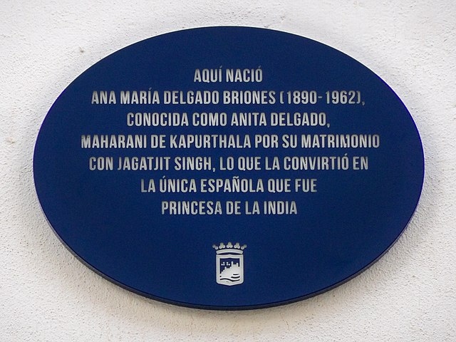 Placa conmemorativa del plan ‘Málaga hace historia’ dedicada a Anita Delgado, bailarina malagueña y princesa de la India, en el número 17 de la calle Peña. Fuente: trabajo propio (CC BY-SA 4.0) disponible en Wikimedia Commons.
Esta semana se ha inaugurado una nueva placa conmemorativa del plan ‘Málaga hace historia‘, en esta ocasión dedicada a Anita Delgado, bailarina malagueña y majaraní (princesa) de Kapurtala. La placa ya aparece en Open Plaques y también puede encontrarse en OpenStreetMap, a la altura del número 17 de la calle Peña.
Todas las placas del plan ‘Málaga hace historia‘ se encuentran en el mapa. Me he ocupado personalmente de ubicarlas tanto en OpenStreetMap como en Open Plaques, donde hay una serie dedicada a estas placas. Hasta el momento se han colocado trece placas. Mi intención es seguir añadiéndolas conforme se vayan inaugurando.