OpenStreetMap logo OpenStreetMap

Users' Diaries

Recent diary entries

Posted by a2021 on 14 October 2024 in Japanese (日本語). Last updated on 20 November 2024.

Geofabrik OSM Inspector

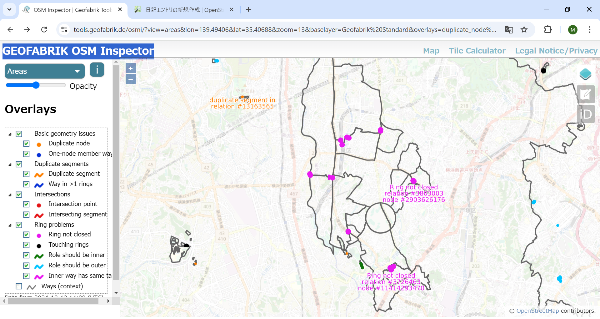
何年か前には、広域森林などがよく壊されていた。 エラーチェックにOSM Inspector をよく使った。 近年は OSM Inspector を使っていない。機能が豊富なので、使いこなすのは簡単ではない。

左上の選択は 「Areas」とする。目下、横浜市泉区をマッピングしているので、そのあたりを 表示してみた。

かなり多くのエラーがある。OSM Inspector でエラーを見つけ、relation とか way などの osm_id を JOSM に入れて、エラーオブジェクトを表示する。

二つのポリゴンで描かれた公園の接合部にエラーがあった。合体させて、一つのポリゴンにした。

boundary=administrativeの一部が欠けていた。このエラーは多くある。 とりあえず、簡単な2件のエラーを修正した。

農地をouter polygonとするマルチポリゴンのエラーも修正した。

OSM Inspector にエラー修正が反映されるのは確か数日後であったと記憶する。

今回、4つのエラーを修正したが、まだ多くのエラーが残っている。 境界線エラーが多いと思われる。

誤って消されたとは限らず、分かる範囲で境界線を描き、不明分が描き残されているのかもしれない。境界線が交差のない閉ループにならなければ、エラーとなる。

道路や河川の県境などは現地確認できるが、詳細な境界線の確認には手がかかる。 残りのエラーのいくつかは後日修正するが、修正できないものもあるだろう。

行政境界線を強調表示する[2024.11.15]

日本地図全体では無数のエラーがある。横浜市泉区では、特に、行政境界線のエラーが多かった。いくつかは修正したが、簡単には修正できないものもある。

See full entry

Hello OSM Community,

I’m currently working on a project to capture 360° images of the city of Salzburg for Mapillary, and possibly for Panoramax later. My goal is to enhance OSM data in Salzburg, especially in areas with notes that could be resolved with better visual context—something 360° images can provide.

Getting the Camera

I reached out to the OSM Belgium team to ask if I could borrow one of their 360° cameras. To my surprise, they informed me that there was already a GoPro MAX 360 in Austria! After checking with the local OSM chat, it turned out that mcliquid had the camera and kindly offered to send it to me.

Route Planning Challenges

Before starting the project, I wanted to plan an efficient route to cover as many streets as possible without overlapping - essentially the Chinese Postman Problem. Unfortunately, I couldn’t find a tool for this problem.

Initially, I tried bikerouter.de to created a GPX route. After importing it into OSMAnd, I found that it wasn’t working as expected - it tried to auto-route between the points instead of following the plan I made. This wasn’t practical for me for capturing 360° images.

The Solution I’m Using Currently

I eventually opted to use OSMAnd’s built-in recording feature. By activating the setting, I could record my route in real-time and have the GPX displayed directly on the map. This way, while cycling, I could instantly see where I had already been and decide on the fly which streets to cover next. This flexibility worked much better for capturing pictures around Salzburg.

Managing the Photos for Upload

From past experience, I knew that the Mapillary uploader struggles when handling too many files at once, leading to issues that require a full reset of the uploading-tool.

To avoid this, I used PowerShell to split the images into folders of 250 files each, which made the upload much smoother and basically error-free. This small step ensured that I could process and upload my imagery without hiccups.

See full entry

Location: Altstadt, Salzburg, 5020, Austria
Posted by pehar_11 on 13 October 2024 in Croatian (Hrvatski). Last updated on 6 June 2025.

Opis projekta

S obzirom da je riječka obilaznica (dionica između čvora Učka i izlaza Sveti Kuzam) ključna cestovna prometnica koja povezuje Primorsko-goransku županiju i grad Rijeku, odlučio sam se za opsežan i detaljan podhvat ažuriranja svih podataka ove autoceste. U planu je cjelokupno i detaljno mapiranje svih postojećih objekata i podataka te dodavanje novih detalja kako bi se karta uskladila sa aktualnim uvjetima i stanjem na autocesti.

  • Status: dovršeno
  • Autocesta: A7 Rupa – Rijeka – Žuta Lokva
  • Obuhvaćena dionica: čvor Učka – izlaz Sveti Kuzam, oba smjera
  • Početak: 1.10.2024.
  • Planirani završetak: 15.3.2025.
  • Završetak: 10.4.2025.

Projekt uređenja riječke obilaznice obuhvaća uređenje postojećih čvorova (ispravak ulaznih i izlaznih krakova), korekciju zelenih površina, zaštitne ograde i područja za akumulaciju oborinske odvodnje, uređenje postojeće signalizacije i uvođenje pozicija LED promjenjivih displeja iznad profila kolnika, ispravak ili ažuriranje podataka o trakama (broj traka, ograničenje brzine), uvođenje pozicija kamera za brzinu te nadzornih kamera sa direktnom poveznicom na URL kamera, ažuriranje daljnih cestovnih pravaca i odredišta na izlaznim i ulaznim krakovima čvorišta, dodavanje informacija o tunelima, duljini tunelskih cijevi, godini izgradnje i tehičkim specifikacijama iste prirode te uređenje svih popratnih površina, SOS ugibališta i odmorišta na području navedene dionice.

Uređenje riječke obilaznice provodi se u etapama kako bi se osiguralo da podaci odgovaraju onima sa terena. U samom početku provodila su se ažuriranja čvorova i njihovih naziva, potom dodavanje zaštitne ograde, nadzornih kamera i ograda za buku, pa ispravak pružanja čvorova, ulazno-izlaznih krakova, dinamičkih displeja te SOS telefona i aparata za početno gašenje požara u zonama tunela i odmorišta.

Projektom su obuhvaćeni:

See full entry

Location: Orbani, Mjesni odbor Rubeši, Kastav, Grad Kastav, Primorsko-goranska županija, 51215, Hrvatska

Hei alle sammen (altså… dere som følger meg fortsatt og kan god norsk). Jeg har bestemt meg for å komme meg tilbake og hjelpe med kartredigering! Jeg hadde vært fraværende særlig lenge, men nå skal jeg ikke det. Jeg skal hjelpe med å oppdatere kartet der jeg studerer i utlandet (Denver i USA) og… trur det er alt da! Ha det fint dere :)

Posted by seav on 12 October 2024 in English.

I recently finished this mini-project where I implemented the classic 15 puzzle game but using the standard OpenStreetMap tiles as the sliding pieces!

While there are many implementations of this game online and in app stores (some even let you upload your own image), as far as I know, not one directly uses OSM slippy map tiles for the pieces. I figured this would be a nifty side coding project and it was fun to do!

Currently you can play any of 20 map locations. Enjoy! 🎉

Play the game here: https://seav.github.io/osm-15-puzzle/

Screenshot of a web app showing the classic 15 puzzle sliding game (scrambled) where each tile shows 1/16 of the whole world in Mercator projection Scrambled puzzle showing the whole world in Mercator projection

See full entry

Posted by Kingsley AMANKWE on 11 October 2024 in English. Last updated on 20 October 2024.

It’s that time of the year again, and once more, I find myself sharing my experience from State of the Map Nigeria 2024. Unlike last year, when we didn’t have workshops, this time we were spoiled with multiple workshops, covering various topics that kept participants actively engaged. Plus, for those who missed any sessions, we now have everything recorded and uploaded to our YouTube channel to revisit at any time!

Unfortunately, as the Programs Lead, I missed many of the live sessions myself. But during the few times I could sneak into a session, I was blown away by the depth and engagement. This conference had that special vibe, the kind that makes you wish it lasted longer. I’m confident that everyone who joined will be excited to return next year.

One of the things that stood out this year was the diversity in our participants. We had people coming from across the north, south, east of Nigeria, and even Ghana! Meeting new faces, like my new friend Calvin Menttor from Ghana, was an absolute pleasure. By the way, I finally got to see the Ghana cedi in person 😄.

To my Tech Crew, Joshua, and Justice, I must confess that I still mix your names up sometimes 😅, but it was a fantastic experience working with you both! Together, we made the media coordination a breeze (though, Justice, you did leave me to freeze by taking the duvet 😂).

Shout-out to my Logistics HoD, Olurunkosebi, and Welfare HoD, Titi. You both made my job so much easier! You ensured that meals arrived on time and that all the participants had a comfortable experience.

And I can’t forget Hajar from TomTom, who supported us with the mapping project used during the conference. Your contributions were invaluable, and we’re incredibly grateful.

See full entry

Location: Kajola, Ife Central, Osun State, 220282, Nigeria

Heatwaves have become a growing concern in recent years, and this year they’ve hit Bangladesh harder than ever, posing serious health risks. Our team, Three Dot, is competing in the Forewarn Disaster Hackathon 2.0, where we’re developing an app to provide heatwave alerts and an AI assistant that offers crucial advice on heat-related health issues.

One of the key features of our solution is providing users with the location of the nearest cooling centers—places with public accessibility, where people can cool down safely. These could be shopping malls, super shops, or mosques—any space that’s well-ventilated and free for the public to stay in.

The challenge we faced is that such attributes don’t exist in OpenStreetMap (OSM) for Bangladesh. Drawing on my previous experience as the former president of YouthMappers at Eastern University, I took the initiative to map out potential cooling centers. We’re tagging these places with: 1) Cooling_center: yes and 2) Cooling_center_bd: yes, to create a reliable resource for users and develop our heatwave project on top of that. Initially, our target location is, Dhanmondi and Mohammadpur.

Our initial focus has been on mapping spaces open to the community, such as large shopping malls and mosques, so that people can find refuge during extreme heatwaves, even if just for a short time.

When I finished high school, I joined the Rwanda Red Cross because I have always loved humanitarian work and felt a strong duty to help people in any way I could. Becoming a trainer with Rwanda Red Cross gave me a sense of purpose in humanitarian action. I first encountered Humanitarian OpenStreetMap (OSM) during a disaster response for landslides and flooding in Rwanda, where many lives were lost. As a volunteer with the Rwanda Red Cross, I was part of the response team. After witnessing the destruction of buildings and roads by the floods, I began to wonder how people could be helped to avoid living in areas prone to such disasters. I thought about the potential of maps to identify unsafe places but didn’t know how it could be done.

One day, a friend introduced me to OSM Rwanda after I expressed my curiosity about maps. I joined the community, and on my very first day, I was trained on the importance of mapping for humanitarian response. I learned how to map roads and buildings, and though it wasn’t easy at first, I was deeply motivated. My curiosity had found a solution, and I was determined to continue contributing to mapping.

I started attending more mapping sessions and OSM events, learning and growing my skills. Eventually, I became a trainer in OSM Rwanda, teaching newcomers about mapping. This role allowed me to learn even more, as teaching others exposed me to different aspects of mapping. Over time, I made significant contributions and applied for a scholarship to attend the State of the Map (SOTM) conference in Nairobi. I believed it would be a great opportunity to expand my knowledge, and I was thrilled when my application was accepted.

See full entry

Подправил Московский Планетарий. не на рекорд конечно, но тем не менее.

Московский планетарий Почти все части были, осталось только расставить высоту.

Пока работал, испытывал стойкое ощущение дежавью, как будто я делаю это второй раз.

Что на очереди, говорить не буду, чтобы не сглазить)

weeklyOSM está completando 10 anos e o conselho editorial agradece a todos os colaboradores!

O semanário Wochennotiz ganhou um edição multilíngue em 2014 e vem publicando as novidades do mundo do OpenStreetMap, a cada semana, fortalecendo a comunidade mundial da cartografia livre.

Por Raquel Dezidério Souto (IVIDES.org e GeoCart-UFRJ)

weekly_logo


Há 10 anos fortalecendo a comunidade global

O semanário, originalmente em alemão, Wochennotiz, ganhou uma edição multilíngue - weeklyOSM , e vem produzindo informes semanais sobre os avanços no OpenStreetMap, em diversas áreas de aplicação.

Em 2014, o semanário contava com uma equipe reduzida, que foi pioneira na tradução dos artigos para seis idiomas. Atualmente, a weeklyOSM conta com mais de cinquenta colaboradores, que criam, revisam e editam conteúdos, traduzidos para quinze idiomas. As seções atuais da publicação são:

See full entry

Posted by lhirlimann on 6 October 2024 in French (Français).

Petite annonce, la communauté des cartographes libre toulousain (je trouve ça plus cool comme intitulé que contributeur à OpenStreetMap), est passé d’un mode de communication essentiellement centré autour d’une liste de diffusion au forum proposé par osm france.

On se retrouve donc ici pour discuter de nos rencontres mensuelles (auxquelles je ne participe pas, car trop loin, pas le bon jour). Des évènements où nous essayons d’être présent et pour l’organisation de carto fête future. Passez nous lire sur le forum si vous êtes dans le coin et nous faire un petit coucou.

Les toulousains tiendront un stand au devfest toulouse et sans doute au Capitole du libre (stand demandé, par encore de réponse).

Location: Capitole / Arnaud Bernard / Carmes, Toulouse, Haute-Garonne, Occitanie, France métropolitaine, France
Posted by Jack_Regan on 5 October 2024 in English.

I started mapping a few weeks ago, sticking (mostly) to North Muirton in Perth for now as I have lived here for 50 years so I think I know it quite well. No doubt I’ll have done a few things wrong along the way but I’ll go back and fix, if and when I realise. As I write this, almost all the houses and flats in NM are at least drawn out with a few streets still to be tagged with the “basics”.

I intend to add (or finish)

  • Electricity Substations (all operated by SSE? - I think they all are)
  • Grit Bins
  • Public Benches
  • Garages (rented out by the local council)
  • Add all postcodes
  • Public pathways (miles of them!)
  • Back fences (the 6ft high ones around all the back gardens)
  • Grassy areas
  • Road crossings
  • Drying greens for the 8 and 4-block flats