
Ce week-end, j’ai été impressionné par la qualité du routage de brouter. Un trajet de 150km sans soucis, j’ai été impressionné.
Je me met donc aujourd’hui à étendre un peu la richesse d’OSM dans mon petit coin de pays.
Merci à toustes
Ce week-end, j’ai été impressionné par la qualité du routage de brouter. Un trajet de 150km sans soucis, j’ai été impressionné.
Je me met donc aujourd’hui à étendre un peu la richesse d’OSM dans mon petit coin de pays.
Merci à toustes
With my State of the Map Working Group - communications hat 👒 , one thing that really put a smile on my face is checking the stats of scholarships given! 😍
Quick stats re scholars from the OSMF SotM WG & Humanitarian OpenStreetMap Team #HOTOpenSummit Travel Grant Programs:
I cannot express enough how amazing it feels to see this stats. As someone who got exposed more to OpenStreetMap community after attending her first global SotM conference six years ago (my diary here), this gave me much hope and encouragement that we’re building an inclusive map and community 🗺 🤝
Uli, 61 Jahre aus Gladbeck. Seit Juni 2024 bin ich Mapper und versuche mich in OSM einzuarbeiten indem ich meinen Heimatstadtteil Buttendorf mal genauer betrachte und Fehler berichtige.
Ich freue mich über Kontakte in Gladbeck und natürlich über Hinweise wenn ich mal was falsch editiere.
Bis bald
Uli
Come closer and let’s have a quick, impactful conversation…
Hear me out. As a student, there are countless opportunities you can tap into, especially when it comes to personal and professional growth and one of the best social clubs to join is YouthMappers.
Imagine being part of a global movement where university students like you are trained free of charge to use powerful mobile mapping apps and software, contributing directly to sustainable development. It’s not just about learning new skills—it’s about making our communities visible, especially those that are too often overlooked.
 But wait, here’s the real question: How committed, dedicated, and ready are you to volunteer and contribute to OpenStreetMap? 🤔 It’s more than mapping—it’s about creating change, ensuring no place is left behind, and bringing solutions to real-world problems.
Giving back to the community has been the focus. On 26_07_24, I had the opportunity to meet the UMaT YouthMappers chapter while attending the 5th WAIMM Students Conference (an annual 3-day conference). I introduced YouthMappers, the basics of JOSM, and OpenStreetMap, especially to the chapter’s ‘youngies’, and explained who we are and what we do. I also shared some success stories to vindicate the benefits of YM, such as broadening interpersonal geospatial knowledge, connecting and networking with like-minded individuals, and belonging to a community of youth who are mappers. We swiftly discussed Mapillary and how it complements JOSM data validation, and also what it takes for a chapter to be sustainable.
Link to the Facebook post with attached images: (https://web.facebook.com/CalvinMenttor/posts/pfbid0NRFz1kToPUASQdr8VQksd1yfduot5jDB8FtoHUns7oNWunagQ3F5e8yfHcFfHhinl)
On March 15th and 16th, OpenStreetMap Ghana (Sir Mawutor) and I visited UCC YouthMappers to familiarize them with how to fly a drone to map and to also map with Mapillary. It turned out to be an excellent result—a massive turnout. Appreciation to Dr. Julia (the Patron) and Dr. Mensah (the GIS lecturer) for creating an enabling environment for the Chapter and to the vibrant TEAM for rendering voluntary service to the membership. This is far-reaching. 🗺️🤌🏾
Link to the facebook post: (https://web.facebook.com/CalvinMenttor/posts/pfbid0SVoqAjDeEgqpPNrt2AS6yyerh3ZnMYH31x25LFaXsGBe5iV3N71dRuF5Ke2VSXrXl)
I am grateful to YouthMappers for providing me with the knowledge and abilities that would enable me to impact and transform deprived communities and contribute to sustainable development. 52 students, 26 countries, and 49 academic institutions—it was incredible to meet these young future leaders who are enthusiastic, passionate, and have the zeal for change through this inspiring leadership summit in Jamaica.
Big thanks to everyone who helped make the summit a success, including the speakers, navigators, photographers, and event planners. I have learned a lot in addition to mapping by learning about the traditions of my fellow nations and dispelling certain misconceptions about Jamaica, the host nation.
I would again like to thank YouthMappers for giving me international exposure. This built my confidence as a change-ready youth leader. I appreciate the recognition.
放送大学の「地理空間情報の活用」第1回番組内で紹介されていました。 自分の生活圏内と出かけ先の地図を盛り立てていきたいです。 アップロード方法?などもわかりませんが…。
Once upon a time a bunch of people decided to start collecting informative bits about stuff they‘re concerned with into a geo-referenced database. They mapped streets – hence the name of their experiment – and also PoIs. Records consist of a so-called tags, key-value pairs. In hindsight tags are differentiated into a primary tag, a.k.a. the substance/essence and a number of secondary tags, a.k.a. the attributes. There‘d be e.g. highway=secondary; name=Abbey Road.
One of those days, somebody noticed a problem: They wanted to map a so-called shared-space, where pedal cycles and pedestrians both allowed and traffic sings put up to show that intention. One solution might have been to tag a highway=cycleway;footway. Thereby turning the right hand side of the tag into a list. This looked ugly, a tag no longer would code for a 1:1 relation but a 1:n relation. Users of the data do not like that.
Some pondering later, the idea was born: Put the function/use/arbitrary detail of the mapped entity into the attributes where they can merrily coexist. foot=designated; bicycle=designated should from now on convey what previously was told by the primary tag. Only problem left: What would be the substance then? It must be something generic, something that provides as little information as possible over what the highway key already contains.
This marked the inception of highway=path as a light and unspecific shim over highway. All it says: It is probably narrow (But don‘t depend on that.) You likely will not see cars moving there. (With few exceptions.)
So they married, and everyone lived happily ever after.
I’d like to announce the release of the new major version 4 of pyosmium.
pyosmium was originally created as a thin Python wrapper around the osmium library, a fast and flexible C++ library for reading, writing and processing OSM data. With the new version 4, pyosmium adds a convenience layer on top which gives the library a more pythonic feel and speeds up processing considerably.
The most important new features are:
Here is an example how to quickly find the most frequent tags used together
with https://wiki.openstreetmap.org/wiki/Tag:amenity=school using the new iterative syntax:
import osmium
from collections import Counter

tag_counter = Counter()
total = 0

for o in osmium.FileProcessor('planet.osm.pbf')\
               .with_filter(osmium.filter.TagFilter(('amenity', 'school'))):
    tag_counter.update([tag.k for tag in o.tags if tag.k != 'amenity'])
    total += 1

for tag, cnt in tag_counter.most_common(10):
    print(f"{cnt:6d} ({cnt*100/total:5.2f}%) {tag}")
Running this on a full OSM planet file takes less than 5 minutes on a 12-core machine with 128GB RAM.
Or do you want to create an thematic extract of schools:
PEMERINTAH PROVINSI PAPUA PENGUNUNGAN 8 KABUPATEN
・この日記機能を使ってみて2か月半。公開の価値はともかく、自分の記録としては便利である。特に、後から編集できるのがありがたい。
・ゆかりの地(地方)を2か所チェックした。 登録時に正しかったが、今は変わっている情報が目に付く。 OSMの利用サイトでは、登録日を表示しているものがあった。 OSMを使うにはそういう配慮がいるかもしれない。 ポイント情報でいいので、もっと多くの人がこまめに登録、修正してくれる日が来ることを 期待している。
・地方でも、交通量が比較的多い幹線道路脇については、コンビニやガソリンスタンド、 人気の飲食店などはそこそこにマッピングされている。 しかし、今も正しい情報かどうかはチェックしていない。 また、Google Mapに比べれば桁違いに登録が少ない。
・医院などは都会でもGoogle Mapに登録されていないことは珍しくない。 自宅近くでは、歯医者はすぐにGoogle Mapに現れる。 これは歯医者は競争が激しく、自らが登録しているのであろう。 一般の医院はホームページを持つていることは多く、検索では現れるが、 当事者がGoogle Mapに登録することは少ないようである。 Google Mapには、悪い口コミも載るので、登録のメリットがないのであろうか。
Prima rotonda disegnata, sono abbastanza soddisfatto.
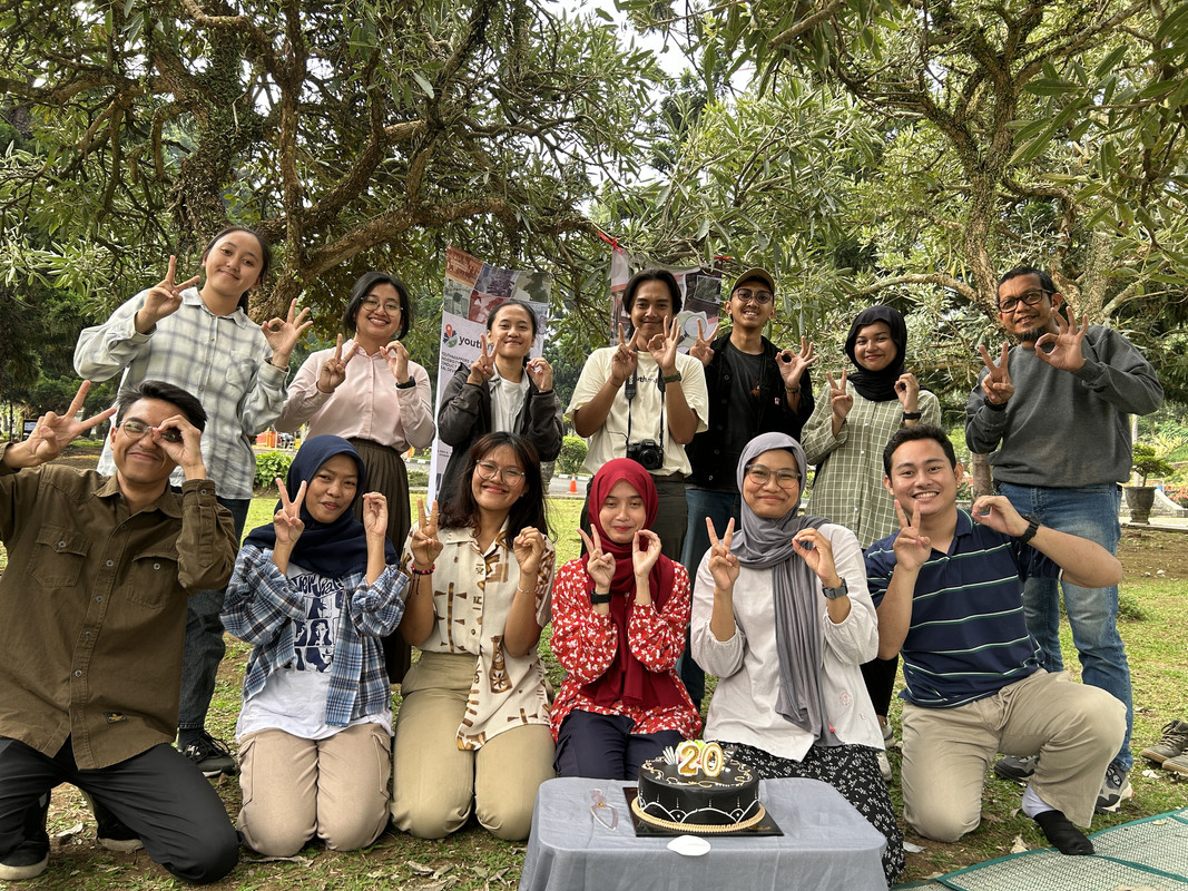
Tanggal 9 Agustus adalah hari ulang tahun OpenStreetMap. Kali ini para editor muda dari Youth Mapper Bandung ikut meramaikan ulang tahun OSM dengan acara potong kue dan bincang-bincang seputar pemetaan OpenStreetMap. Acara ini berlangsung hari Minggu, tanggal 11 Agustus yang lalu berlokasi di halaman depan Universitas Pendidikan Indonesia.
August 9th is the anniversary of OpenStreetMap. This time, the young editors from UPI Youth Mapper are celebrating the OSM Anniversary with a cake and blow the candle, continued by chit-chat around OpenStreetMap thingy. This event was held at the park in front of Universitas Pendidikan Indonesia.
Erstmal ein herzliches Dankeschön an alle, die OpenStreetMap möglich machen. In Kombination mit StreetComplete kann ich Menschen motivieren, ihre Anliegen zu verfolgen. In meinem Blog hier möchte ich auf Dauer Beispiele einstellen und mit anderen Aktiven vernetzen.
Dorothee Janssen, Netzwerk für Inklusion im Bistum Essen
A project I worked on, the Toronto Public Washroom Import recently finished up and I thought it would be interesting to do a quick lessons learned:
https://wiki.openstreetmap.org/wiki/Tag:.value_counts(dropna=False) in pandas.On Saturday, September 14, 2024, Pakistan hosted its first-ever mapathon, a collaborative event aimed at contributing to the OpenStreetMap (OSM) community. The mapathon took place in Islamabad, Karachi, and online, bringing together a diverse group of participants.
In Islamabad, mappers gathered at the “Calmkaj” workspace, while in Karachi, they convened at the Habib University computer center. The day began with opening remarks by Mr. Shaji from COP, followed by an introduction to maps by Ms. Zainab Makti, a lecturer at Habib University.
I then provided an overview of OpenStreetMap, covering its purpose, community, global impact, and applications. Given the presence of many new mappers, I conducted a hands-on training session on editing and participating in Maproulette challenges. Training materials were also shared through WhatsApp and other social media groups prior to the event.
With over 60 participants in total (20 onsite in Islamabad, 30 in Karachi, and 16 online), the mapping session was a productive and engaging experience. I closely monitored edits and provided assistance to new mappers, ensuring the quality of contributions. To maintain enthusiasm and encourage participation, we announced prizes for the top Maproulette scorers.
Throughout the day, we enjoyed a lunch break provided by the COP team and participated in a fun quiz based on the training session. The event concluded with the distribution of prizes to the top three Maproulette performers.
The mapathon was a resounding success, attracting 30 new members to the Pakistani OSM community. Participants expressed interest in working on various mapping projects, including pharmacies and health centers in Peshawar and Islamabad, banks and their branch codes, water sources and union councils, and mangroves.
Mexico

Aghju aghjustatu assai macchia intornu à Patru è fureste statali à Pianedda. Hà aghjustatu ancu macchia à a gola d’Azzanido. Viva a Sardegna libera da l’Italia !
Procurad’e moderate, barones, sa tirannia, chi si no, pro vida mia torrades a pe’ in terra ! Declarada est già sa gherra contra de sa prepotenza: e incomintza’ sa passenzia in u so populu a mancare !

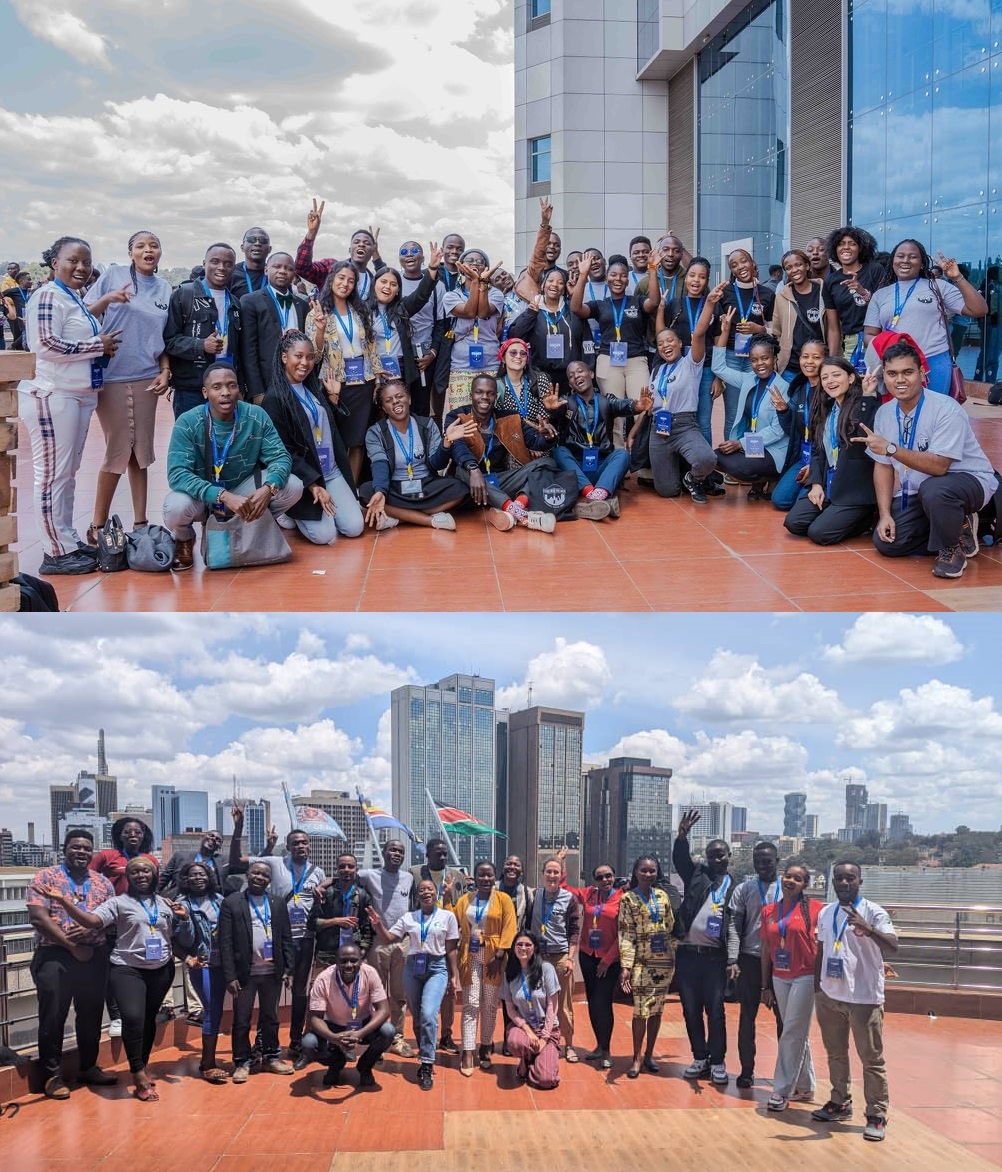
State of the Map 2024, Nairobi-Kenya: An Unforgettable Experience!
Wow! SotM 2024 in Nairobi, Kenya!!! I couldn’t contain my excitement when I received an email confirming that I’d been granted a full scholarship to attend the event. It was my first time attending the global State of the Map conference, and the thrill of meeting so many people from diverse backgrounds and regions was overwhelming. I even screamed when I read the news—why not? I was about to meet in person people I had only ever interacted with online, and the feeling was indescribable.
The first thing I did was reach out to my fellow OSMers, who I consider family, to confirm who else was attending. The joy from those who affirmed they’d be there was palpable. We kept in touch, discussing our preparations for the big day. Butterflies fluttered in our stomachs as excitement built. We knew exactly when everyone would arrive in Kenya.


