Zannat Street
Users' Diaries
Recent diary entries
area fix
Posted by Zkir on 27 September 2024 in Russian (Русский).
Last updated on 30 September 2024.

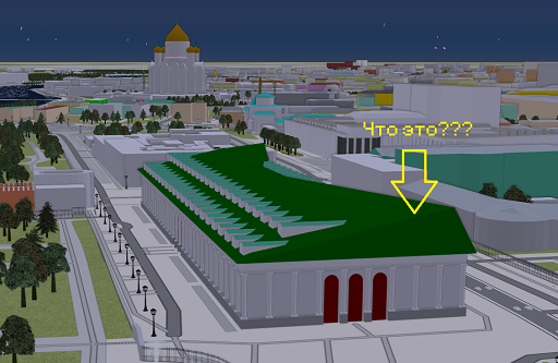
Я очень горд собой, я перепилил Московский манеж. :”) Как никак это один из наших архитектурных шедевров.
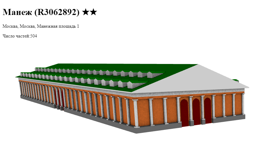
Доводить его до 6 тысяч элементов наверно смысла нет, хотя возможность такая есть)
У меня в рендере выглядит нормально, а F4 что-то подколбашивает.
On November 13, 2023, Miami-Dade County’s transit agency, Miami-Dade Transit, implemented significant changes to its bus network - designated the “Better Bus Network.” These updates aimed to enhance coverage for neighborhoods and business districts that primarily serve lower-income residents. As a result, many routes and stops were altered, relocated, or removed.
To the best of my knowledge, much of Miami’s transit data on OSM was originally contributed by user drynwk around 2021. Most of their contributions have remained untouched for nearly three years, despite the major changes from the Better Bus Network almost a year ago.
Miami-Dade Transit has provided updated transit information to platforms like Google Maps, Apple Maps, and likely other GIS services. I believe it’s essential that OSM volunteers also have access to this data. To that end, I’ll be making an effort to obtain the relevant information from Miami-Dade Transit and share it with the OSM community here in Miami.
In addition, I plan to update the bus route relations on OSM to reflect the new route names, ideally matching the official names used by Miami-Dade Transit across their buses, maps, and app. I’ll also be reaching out to request the correct route names for accuracy.
Edit: On November 25, 2024, there will be another revamp to the Better Bus Network. These service adjustments will affect most routes, and as such, will postpone my project.
Hallo Open StreetMap ist wirklich ein sehr cooles Projekt, Respekt und Dank an alle Menschen die das durch ihre hervorragenden Leistungen möglich machen. ich habe jetzt länger gesucht ob man die Weltkarte nicht auf Englisch umstellen kann , ich bin leider bei längerer Suche nicht darauf gestossen , wo ist denn der Umschaltknopf auf englische Sprache , ich kann leider nicht Russisch Arabisch oder Chinesisch usw lesen… des weiteren benutze ich viele Linux Software mit OSM Karten leider nicht mehr auf Englisch das ganze …kann mir jemand weiterhelfen?
การดูมุมมองจากที่สูง
ธรรมชาติที่แสนหาดูอยากจากมุมองจากที่สูง

Hi all!
I’m Freya and been a contributor since April 2024. I’ve since then noticed there is a lack of diversity that covers different groups of people to make them feel welcome or drive questions as a team rather than as spread out individuals here and there
We will not be doing work that Local Chapters and Communities Working Group is already doing, instead we will be working towards highlighting ways to be inclusive, organizing projects to increase accessibility in specific areas, or just hosting a friendly place for people to chat in!
To start with I’ve setup a wiki page containing what exactly the goal is and how we will work, and my plan is to develop this initiative as time goes on and more people get interested
We also use the Contributor Covenant v2.1 as our Code of Conduct
No projects setup yet but in the plans to organize an event soon! :pray:
Here’s a few resources I’ve setup for now

امروز فرارت شلوغ بود ترافیک زیاد و چندتا ماشینم خراب شده بودند
امروز فرارت شلوغ بود ترافیک زیاد و چندتا ماشینم خراب شده بودند
Posted by TrickyFoxy on 26 September 2024 in English.
Last updated on 6 October 2024.

Visualization of changesets, dis/likes, more hotkeys and viewing old versions of map objects
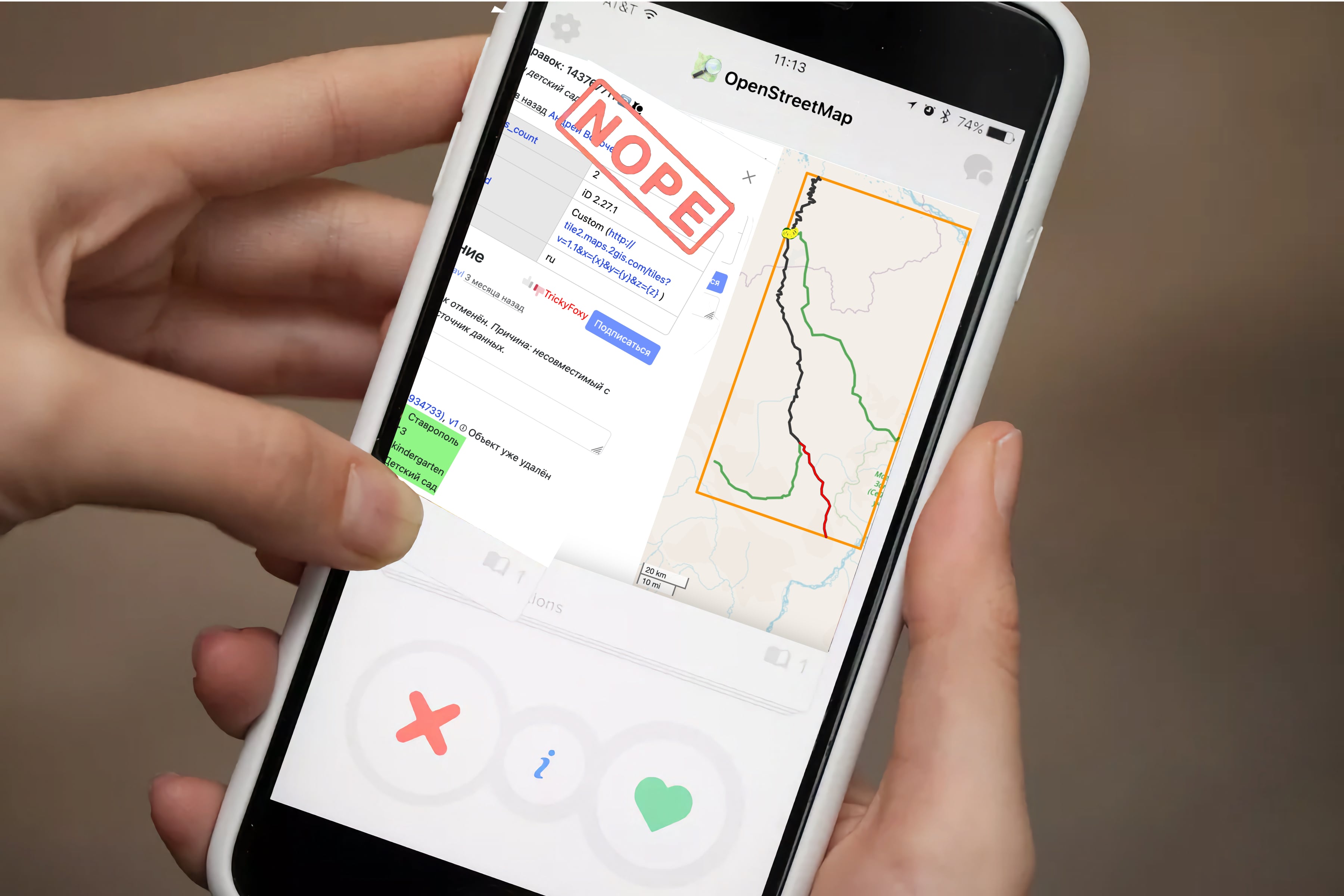
🖼 Visualization of changesets
Previously, you could only view changes in tags and only minor changesets. Now you can see objects that have been changed, and pagination is removed whenever possible:
Posted by UNGSC-DTLM-Ale_Zena on 26 September 2024 in English.
Working mainly in Africa it’s not rare to come across to crowdsourced powered mapped areas. I still repair, from time to time, the disaster done in 2022 in Mogadishu
Today, near Bor osm.org/#map=17/6.178444/31.578194 , another masterpiece: a lot of triangular (one 2600 sqm trapezoidal) buildings, and 3 tourism=camp_site
Who does need this rubbish? How good the validator to the related HOT task worked?
Alessandro
Posted by Joseph Munyenze on 26 September 2024 in English.

Hello fellow mappers! 👋
As an avid contributor to OpenStreetMap, I’ve found that having quick access to helpful resources can make the mapping process smoother and more enjoyable. Whether you’re mapping disaster-stricken areas 🌪️ or filling in the gaps for unmapped communities 🏞️, these resources will help you along the way.
Here are some key tools and resources that have been invaluable for me during my mapping journey:
🔑 OSM Resources for Mappers
-
OpenStreetMap Wiki
A comprehensive resource on all things OSM, including documentation, tagging guidelines, and community projects.
➡️ OSM Wiki -
LearnOSM
If you’re new to mapping, this guide is an excellent starting point. It covers the basics and also includes more advanced tutorials for improving your mapping skills.
➡️ Learn OSM -
HOT Tasking Manager
If you want to contribute to humanitarian mapping projects, the Humanitarian OpenStreetMap Team (HOT) Tasking Manager helps you find tasks related to disaster response and global development.
➡️ HOT Tasking Manager -
iD Editor
A simple web-based editor that’s perfect for beginners. You can edit maps directly in your browser without the need for external software.
➡️ iD Editor -
JOSM (Java OpenStreetMap Editor)
A more advanced desktop editor for OSM, offering powerful features for experienced mappers who want to work on larger projects.
➡️ JOSM Editor ➡️ JOSM Download -
Mapillary
This tool lets you access street-level imagery for places where map data might be missing or outdated. It integrates well with OSM for adding detail to map features.
➡️ Mapillary -
Overpass Turbo
A query tool for filtering specific OSM data, helping you search for, and visualize, map features based on tags or location.
➡️ Overpass Turbo -
OSMCha
A tool for reviewing changesets and helping to ensure map quality. It’s great for monitoring edits and improving the accuracy of mapping data.
➡️ OSMCha
🧑🤝🧑 Join the Community

I really wanted to participate in the State of the Map 2024 in Kenya to broaden my horizons, understand what is happening under other skies and exchange with members of other communities to draw from their experience: How they are organized and how they stay dynamic. My illusions found a dazzling light, from the moment the scholarship team accepted my application. I was so happy like my wedding day. 😃
The 3 days were each particularly better, the different subjects selected were breathtaking
Posted by Raquel Dezidério Souto on 26 September 2024 in Brazilian Portuguese (Português do Brasil).
Last updated on 29 September 2024.
O IVIDES.org promoveu o Seminário em apoio ao Rio Grande do Sul, com a participação de cientistas que atuaram durante a fase crítica do desastre.
As apresentações de palestras incluíram abordagem sistêmica no planejamento ambiental; mapeamento colaborativo; softwares livres e dados abertos na redução de riscos de desastres; e geografia crítica.
Contexto
O estado do Rio Grande do Sul (Brasil) foi acometido por um dos maiores desastres socioambientais do Brasil, com 173 mortes, 478 municípios atingidos (do total de 497) e cerca de 2,3 milhões de pessoas afetadas, segundo os dados da Defesa Civil do Estado [1].
No entanto, a importância dos dados abertos e dos programas livres ainda não está clara para muitos gestores públicos e outros atores, o que leva à ineficácia das ações e das políticas de prevenção e mitigação dos danos causados por desastres. O Instituto Virtual para o Desenvolvimento Sustentável - IVIDES.org tem realizado ações abertas ao público, há alguns anos, no sentido de contribuir para o aumento da conscientização a respeito das oportunidades proporcionadas pelo software livre e pelos dados abertos, em diferentes contextos. Nessa via, o IVIDES.org tem atuado também na formação de novos(as) mapeadores(as) do OpenStreetMap, mantendo um curso de capacitação on-line e completo, disponível em https://curso-osm.ivides.org, com emissão de certificados, duas vezes ao ano.
Posted by umbraosmbr on 25 September 2024 in Portuguese (Português).
UMBRAOSM - the union of Brazilian openstreetmap mappers celebrates Free Software Week in Brazil 2024 with a mapathon in Bairro Corrego do Genipapo, city of Recife-PE - Brazil, on 27/09 at 10:30am Brasília time, UTC-3 .
Task Manager: #TM17643
Programming of activities; https://plantaformas.org/conferences/semana-software-livre-brasil
Mapatona can be followed through our YouTube channel;
Collaborative mapping in the Corrego do Jenipapo neighborhood - Recife-PE_27-09_10:30
https://www.youtube.com/watch?v=5ANyJ9gg0XQ
Contact: Email: [email protected]
website: www.umbraosm.com.br
Punt 1
Posted by Zkir on 25 September 2024 in Russian (Русский).
Last updated on 26 September 2024.
Кто-нибудь умеет в нейронные сетки?
Кажется, технологии созрели в достаточной степени для того, чтобы генерить нейросетками хотя бы двумерные изображения зданий по словесным описаниям, сделанными из тегов.
Я попробовал Кадинского. Рисует он неплохо, но архитектурная терминология для него ничего не значит, и в добавок он считать не умеет.
Промт: “Здание железнодорожного вокзала в псевдорусском стиле четыре этажа, акварель.”
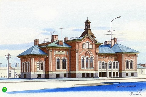
Неплохо. И правда напоминает провинциальный вокзал, но искусственный мозг не понимает, что у здания должен быть вход. (А у вокзала еще и обязательно с двух сторон, хе-хе.) Требование про четыре этажа проигнорировано.
Промт: Белая шатровая церковь в стиле нарышкинское барокко, с пятью куполами, акварель.
I am happy to receive the HOT Open Summit scholarship to attend the State of the Map 2024 held in Kenya. I can give a lecture on-site. But unfortunately, I got influenza and felt very ill during my trip to Kenya. Most of the time I have to stay in bed. So sad I can’t join the meeting during the conference.
 (Photo credit: Arnalie)
I had to skip the first day of the conference in the first day due to illness. But I feel better the second day. The conference was held in the hall in Nairobi Tower, University of Nairobi, which is quite comfortable for all of us attendees. This is my third State of the Map, the second time in person.
It seems that the conference was held in Africa and quite a distance from most of the OpenStreetMap contributors. There is a much smaller size compared to other years’ State of the Map conference. It is still a very valuable experience. Face-to-face communication is still the most effective way to communicate between OpenStreetMap contributors.
真歡喜得到HOT Open Summit的補助金參與這改佇肯亞舉行的State of the Map 2024,會當去現場發表我的演講主題。毋過真可惜去的時陣破病,倒佇眠床休養,無法度有真濟佮參與者的互動。
(圖片:Arnalie翕相)
大會第一工倒佇眠床規工,第二工才有法度去會場。佇大學內底的高塔建築Nairubi Tower的會議中心舉行,算是真四序的場地。這是我第三改參與State of the Map,第二改現場參與。可能因為去非洲的路途較遠,整體規模較細,毋過會當面對面交關是真寶貴的體驗。家己有拄著一个編輯器開發者,伊共我講伊熟似yellowsoer,佮伊反應Go Map!!的問題。𪜶太太是台灣人,所以一直佮𪜶翁仔某開講。𪜶講欲來台灣一逝,到時欲來聚會。
我家己的演講部份,分享地址匯入工課,順紲講台灣社群最近咧無閒啥。有人回應問以後資料更新的部份按怎進行,我老實講有拄著閣討論,若是有發現問題就修正,照OpenStreetMap的規則進行。