OpenStreetMap logo OpenStreetMap

Users' Diaries

Recent diary entries

Posted by TrickyFoxy on 2 August 2023 in English. Last updated on 3 August 2023.

It seems that there is only one instruction for getting fresh Sentinel-2. It tells you quite well how to prepare images, but it is difficult to explain how to use them in OSM editors. So after step 7, you can do

without GeoTIFF and tile server
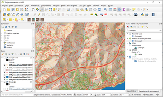
  1. Select in QGIS: Processing->Toolbox->Raster Tools->Generate XYZ tiles (MBTiles)
  2. Set the parameters:
    • to Extent of the map area you need.
    • Maximum Zoom is most likely 15.
    • In Output Path, specify where to save the tile file
  3. Click Run and wait for rendering to finish.
  4. Install the mbtiles plugin in JOSM
  5. Open the file you received in step 3.

By the way, recently Guru Maps learned how to tear off MBtiles https://gurumaps.app/blog/2023/06/14/mbtiles


But if you still want a tile server, you can do without tileserver-php from the instructions. And without the QTiles plugin, it will also work faster!

Classic tiles with a web server

  1. Select in QGIS: Processing->Toolbox->Raster Tools->Generate XYZ tiles (Directory)
  2. Set the parameters:
    • to Extent of the map area you need.
    • Maximum Zoom is most likely 15.
    • Set Output Directory. You can immediately select the directory of your web server.
  3. Click Run and wait for rendering to finish.
  4. Start your web server. If you didn’t use Nginx or Apache, open the folder with your tiles in the terminal and try using the web server in Python: python -m http.server 80 or PHP: php -S 127.0.0.1:80
  5. In JOSM, open Preferences->Layers->+TMS
  6. Enter a URL like this: http://localhost/<tile folder name>/{zoom}/{x}/{y}.png
  7. Get closer to the desired area in JOSM and select your new layer from the Layers menu.

p. s. I used QGIS 3.32.1-Lima.


upd: method from @maraf24

Classic tiles for JOSM without a web server

Instead of starting the web server, specify the following URL in JOSM: file://<absolute path to the folder with tiles>/{zoom}/{x}/{y}.png

Кажется существует единственная инструкция по получению свежих снимков Sentinel-2. Она неплохо рассказывает, как подготовить снимки, но сложно объясняет, как использовать их в редакторах OSM. Поэтому после шага 7, можно обойтись

без GeoTIFF и тайлового сервера

  1. Выберите в QGIS: Processing->Toolbox->Raster Tools->Generate XYZ tiles (MBTiles)
  2. Задайте параметры:
    • в Extent нужную вам область карты.
    • Maximum Zoom скорее всего вам нужен 15.
    • В Output Path задайте куда сохранить файл с тайлами
  3. Нажмите Run и дождись завершения рендеринга.
  4. В JOSM установите плагин mbtiles
  5. Отройте файл полученный на шаге 3.

Кстати, недавно Guru Maps научился отрывать MBTiles https://gurumaps.app/blog/2023/06/14/mbtiles


Но если вы тайловый сервер всё-таки хочется, то можно обойтись без tileserver-php из инструкции. И без плагина QTiles, что будет ещё и быстрее работать!

Классические тайлы с веб-сервером

  1. Выберите в QGIS: Processing->Toolbox->Raster Tools->Generate XYZ tiles (Directory)
  2. Задайте параметры:
    • Задайте в Extent нужную вам область карты.
    • Maximum Zoom скорее всего вам нужен 15.
    • Задайте Output Directory. Можно сразу выбрать директорию вашего веб-сервера.
  3. Нажмите Run и дождись завершения рендеринга.
  4. Запустите ваш веб-сервер. Если вы не работали Nginx или Apache, то откройте в терминале папку с вашими тайлами и попробуйте использовать веб-сервер в Python: python -m http.server 80 или PHP: php -S 127.0.0.1:80
  5. В JOSM откройте Настройки->Слои->+TMS.
  6. Введите URL вида: http://localhost/<имя папки с тайлами>/{zoom}/{x}/{y}.png
  7. Приблизьтесь к нужной вам территории в JOSM и в меню Слои выберите ваш новый слой.

p.s. я использовал QGIS 3.32.1-Lima.


способ от @maraf24:

Классические тайлы для JOSM без тайлового сервера

Вместо запуска веб-сервера в JOSM можно указать URL вида: file://<абсолютный путь до папки с тайлами>/{zoom}/{x}/{y}.png

This OSM diary is an English translation of Yekastreet’s OSM diary post called Sobre el “Mapping Workshop 2023”. Translating and re-posting because I enjoyed it so much :D

A reflection of YEKA and our journey…

Among the many kilometres of routes we have mapped in the seven years since Youthmappers started, our own journey as YEKAStreetMGA continues to surprise and please us the most. We have grown as a team, from our first mapathons in the barely equipped classrooms of the university, to the partnerships we are now forming with our local mapping networks. Design by design, we make the use of open data tools a little more accessible. Through methodological design (a term unthinkable for us in the early days), we have now transformed our first university meetings into structured processes to disseminate and share our knowledge with a new community of mappers.

What we have experienced as students, as women, in a socio-political context that routinely places us between non-functional institutionalism and the uncertainty of self-management in educational processes, reaffirms once again that teaching is a highly political act. Empowering. Essential in the construction of new models of society. And, in a country where making community is a crime, mapping and locating ourselves is in itself an act of humanitarian rebellion. Here we are, here we exist, more than planimetry and satellite rasters. We are vectors on the map, with direction and meaning. And our dedication and commitment to cultivating and growing the community in Central America overcomes the risks and dangers.

Central America yes, because when we speak of Latin America we make invisible the particular individuality of Central Americans, we exist between Mexico and South America, and although we share, we are indisputably different from the rest of Latin America in our struggles, way of life, needs and challenges.

See full entry

Posted by YEKA Street MGA on 1 August 2023 in Spanish (Español). Last updated on 2 August 2023.

Una reflexión de YEKA y su recorrido…

Entre todos los kilómetros de trayectos que hemos mapeado en estos últimos siete años desde que iniciamos con Youthmappers, nuestra propia trayectoria como YEKAStreetMGA es la que nos llega con mayor sorpresa y gratificación. Hemos crecido como equipo, desde nuestros primeros mapatones en las aulas apenas acondicionadas de la universidad, a las alianzas que estamos formando ahora con nuestras redes locales de mapeo. Diseño a diseño metodológico, para hacer un poco más accesible el uso de las herramientas de open data. Empezando por el uso del término diseño metodológico, que era impensable para nosotras en nuestras primeras reuniones de universidad que ahora se han transformado en procesos estructurados para divulgar y compartir nuestros conocimientos con una nueva comunidad de mapeadores.

Lo que hemos vivido como estudiantes, como mujeres; en un contexto sociopolítico que rutinariamente nos coloca entre la poco funcional institucionalidad o la incertidumbre de la autogestión en los procesos educativos, nos reafirma nuevamente, que enseñar es un acto altamente político. Empoderador. Esencial en la construcción de nuevos modelos de sociedad. Y en un país donde hacer comunidad es un crimen, mapear y ubicarnos es en sí, un acto de rebeldía humanitaria. Aquí estamos, aquí existimos, más que planimetrías y rásteres satelitales. Somos vectores en el mapa, con dirección y sentido. Y nuestra dedicación y compromiso a cultivar y cosechar comunidad en Centroamérica se sobrepone a tales riesgos y peligros.

Centroamérica sí, porque cuando hablamos de latinoamérica invisibilizamos la individualidad particular de los centroamericanos, existimos entre México y América del Sur, y aunque compartamos somos indiscutiblemente diferentes del resto de América Latina en nuestras luchas, modo de vida, necesidades y retos.

See full entry

Location: Los Robles, Distrito I, Managua, 14033, Nicaragua

Hello everyone, better late than never, and yeah, that’s my first time here =D

This is meant to be a testimonial covering a somewhat more technical part, for a more “fun” version, I made a thread on Twitter* with LOTS of good photos!! (last year I’ve made a similar) !!

Well, in the beginning, I wasn’t expecting to even be at the event, like, another continent, too expensive travel… I’ve submitted my piece of work, that I was already working on It was (accepted)[https://talks.osgeo.org/foss4g-2023/talk/CRPWUS/]!

Then I’ve been approved for the travel grant program and also as a volunteer!!! I was so so glad, then I need to say thanks again for OSGEO, FLOSSK, UFPR, and HOT they were the ones that made the travel possible!!

Kosovo is a lovely country, there’s amazing and quite affordable food everywhere! Also, the locals and the “locals”, but from Albania (I found this shared sense of belonging very enchanting) received me very well, I got to know many badass people from FOSS community, like the giants from OpenLabs and Cloud 68, they are incredible people and contributors, now I’m really eager to get to know Tirana!

Now getting to the promised technical part: I saw so many solutions and applications, It’s so amusing to see ever-growing FOSS software, including in fields like 3D GIS and even digital twins fancy stuff.

As an OSM lover what I found most heartfelt was that everyone was so fond of OSM there, all applications with base maps had some OSM flavor/derived there, and all making analysis using OSM as the main or one of the data sources…

See full entry

Location: Innovation and Training Park Prizren, Kurilat, Prizren, Municipality of Prizren, District of Prizren, Kosovo

Do we (OSM) have a league table for all countries/ entities (non-countries?), which is based on the quality of OSM mapping in that country?

I ask this question, because I was undertaking a MapRoulette challenge, to help with mapping in Algiers, and although some pockets of excellent mapping existed, it seemed clear that this was very much the exception.

  1. How do we gather metrics, to assess the quality of mapping in a given country, so that quality can be improved?

  2. How do we engage with the ‘local’ OSM community, to perhaps help them to improve mapping?

  3. Can we define a regular (and repeatable) set of MapRoulette challenges, that would enable remote mapping to be carried out, in support of ‘hands-on’ mapping/ surveying carried out by ‘locals on the ground’?

  4. How do we publicise tools such as StreetComplete, to help populate the data/ metadata of a country, in order to build upon the ‘big picture’ data that is gathered?

  5. What are we missing, above?

Please add to this, and edit, as appropriate.

Many thanks,

Chris

Posted by Tomas_J on 30 July 2023 in English. Last updated on 19 April 2025.

My personal list of the OSM projects for Slovakia (assorted by importance):

  • house numbers adding
  • cyclo routes adding
  • tracks adding (based on strava heatmap)
  • new bildings adding based on ortophoto
  • wikidata and wikipedia tags adding
  • waterways adding
  • railways tracks (re-)numbering
  • cry me a river - river precising
  • run forest run - forests’ precising
  • changes sets` review requests from new users
  • railway lines (long distance, commuters) - https://loom.cs.uni-freiburg.de/global
  • school/ agricultular (ex. JRD) areals
  • 3D buildings (churches, POI buildings…)
  • roundabouts precising
  • rail and informal path crossings’ access (type: node child railway child (highway=path -access=no)) -maxspeed -missing power lines

ToDos:

Welcome tool - https://welcome.osm.be/europe

Surfaces - https://data.humdata.org/m/dataset/slovakia-road-surface-data

JuRaVa cycloroute - to map by armchair mapping

Oprava názvov ulíc| Wikidata

Location: Očová, District of Zvolen, Region of Banská Bystrica, Central Slovakia, 962 23, Slovakia

Inspired by my endeavours to create a colour-coded map of sewer vents/ stink pipes by manufacturer, and by my county council’s endeavour to undertake a survey of holy wells, I started adding name:etymology:wikidata first to the holy wells in Co. Kilkenny, but then to the whole of Ireland.

I had produced a video about mapping holy wells in March 2021, but I think I need to make an updated one, because I was oblivious of the name:etymology group, and instead, had suggested people use subject:wikidata. Silly me. But at least, I only had to retag some of them rather than looking up every name.

Some saints or holy people like St. Patrick and “Our” Lady where easily identified, of course, but there were some very obscure saints there for which I had to create wikidata entries. For some, I just could not figure out which saint the holy wells were named after. I also had to skip St. Brigid and St. Kieran, because either name relates to more than one saint.

The first night I did this, I gave every saint a colour or colour combination, but I had to give up on that, because it is called the land of 1,000 saints after all. Here’s a list of saints IN Ireland on wikipedia: https://en.wikipedia.org/wiki/List_of_saints_of_Ireland. There are holy wells named after Biblical saints and early, non-Irish saints as well.

Some holy wells are also not named after a saint, but after the cure they supposedly give, Tobernasuil would be healing eyes, for example. That’s how far my Irish goes… But I’ve asked someone for help. But I added the wikidata identifier for “eye” in that case.

See full entry

Posted by Barro on 29 July 2023 in Finnish (Suomi). Last updated on 2 June 2024.

Lisäilen ja päivittelen OpenStreetMapiin pyörätelineitä menetelmin, jotka on muuttuneet ajan saatossa, kun olen löytänyt uusia käytäntöjä ja sovelluksia tähän hommaan. OpenStreetMapin wikissä on myös kattava yleisen tason esitys siitä, että mitä kaikkia menetelmiä on yleisellä tasolla kartoittamiseen tarjolla, josta voi myös hakea vinkkejä.

Seuraavissa luvuissa tarkastellaan hieman eri lähestymistapoja pyöräpysäköintimahdollisuuksien syöttämiseksi OpenStreetMapiin, joita olen itse käyttänyt saadakseni pyörätelinetiedon lisäämisen OpenStreetMapiin suhteellisen vaivattomaksi. Näitä menetelmiä voi hyödyntää myös minkä tahansa muun paikkapistetyypin lisäämisessä OpenStreetMapiin.

Varusteet

Liikun yleensä ympäriinsä sähköavusteisella polkupyörällä. Minulle on tärkeämpää löytää ja päivittää pyöräilyyn liittyviä paikkapisteitä kuin saada joltain tietyltä alueelta mahdollisimman kattavaa karttaa aikaiseksi. Joten polkupyörä on tässä tapauksessa se loogisin liikkumisväline.

Aluksi välineistössä oli pelkästään kännykkä, mutta sitten erikseen hankin 8” täppärin pääasialliseksi OpenStreetMap-navigointi- ja -lisäyslaitteeksi. Tämä kulkee pyörän tangossa RAM-kiinnikkeillä (kuva 1), joka mahdollistaa koteloriippumattoman kiinnityksen. Tällä hoituu suurin osa työsarasta, kun kentällä lisäilee ja tarkistaa paikkapisteitä sitä mukaa, kun niitä tulee vastaan.

See full entry

Posted by Hungerburg on 29 July 2023 in English.

Rock glaciers – a mixture of ice and gravel that very slowly flows down a slope – are not mapped much. So it seems. Let us have a look. They are said to cover 167.2 out of 12.640 km² in the province where I live, so no small feat.

There is an inventory of 5769 polygons for them in mountainous Austria available for free online. Here to the description - https://doi.org/10.17738/ajes.2020.0001 - Here to the data - https://doi.org/10.1594/PANGAEA.921629

As usual, data is BIG. Let us trim it down a bit first: We only want rock glaciers in the narrow sense, of those only the so-called intact ones, and that not so overnoded.

ogr2ogr -simplify 0.01 -s_srs RGs_all_LambertProj.prj -t_srs EPSG:4326 Blockgletscher.geojson RGs_all_LambertProj.shp -where "LfState='INT' and LfType='rg'"

Resulting Blockgletscher.geojson loads quickly into JOSM. We can now pan and zoom the data smoothly over OSM-Carto background. This goes to show that rock glaciers are in fact mapped! Yet not as one might infer from the name, as natural=glacier, but natural=scree instead, at least, where there is something mapped at all and not just blank space.

See full entry

Location: Pfunds, Bezirk Landeck, Tyrol, 6542, Austria

Ich hab mal die etwas interessanteren overpassabfragen aus meiner lokalen Sammlung zu meiner Wikiseite hinzugefügt. Zum einen, damit auch andere was davon haben, zum anderen, damit ich die auch an anderen Rechnern habe und die nicht rumtragen muss.

Alles noch recht durcheinander und tlw. mgl. doppelt, sortier ich andermal. Da sindse: osm.wiki/User:Dex2000#Neu

P.s. “meine” in Anführungszeichen, weil ich die alle irgendwo zusammengesammelt habe und bestenfalls nur modifiziert.