OpenStreetMap logo OpenStreetMap

Users' Diaries

Recent diary entries

Con oggi, 26 giugno 2022, è stato completato da parte mi il lavoro di rifacimento delle relazioni delle seguenti reti urbane autobus del Friuli Venezia Giulia: urbana Monfalcone, urbana Lignano, urbana Grado

MONFALCONE (aggregato Ronchi e Staranzano)

LIGNANO SABBIADORO (annesse fraz. Pineta e Riviera)

GRADO (annesse fraz. Pineta e Valle Cavarera)

TRIESTE

Aggiunta diramazioni linea G51 per la Wartsila e per Piazza Oberdan, nonchè la correzione dei tratti e delle fermate mancanti della tratta per l’Aeroporto di Ronchi. Aggiunta in data odierna anche la linea 20 express per Muggia.

Oltre alle relazioni sono state create (ove mancanti) le fermate ed i vari spezzoni per permettere l’inserimento del percorso; inoltre ho aggiornato le etichette nelle fermate con tag e valori obsoleti.

  • Alessandro Carmeli
Location: Grado, Gorizia, Friuli-Venezia Giulia, 34073, Italia

(original post in English)

Selon les régions considérées, la pratique habituelle du ski nordique est différente. Si en Europe de l’ouest, dans la grande majorité des cas on peut s’attendre à ce qu’une piste de ski de fond soit préparée avec un plan lisse pour le skating et au moins un paire de rails pour le style classique, ce n’est pas le cas partout dans le monde.

Dans certaines régions, la préparation des pistes est plus légère, et la pratique du ski de fond majoritaire est plutôt celle du « ski de randonnée nordique » avec des skis larges. Image Crosscountry vs classic, skating

Sur OpenStreetMap, pour différencier ces pratiques très différentes, on utilise le tag piste:grooming .

Mais aujourd’hui (25.06.2022), pour 24 % des pistes de ski fond, soit tout de même 22’303 km, impossible de savoir quels skis prendre.

Alors cet été, à défaut de sortir la dameuse du hanger, à vos souris pour renseigner les pistes que vous connaissez !

See full entry

31.05.2022 I have published an open letter to the members of the OSMF foundation board regarding the problems I believe the community is facing in creating the main style of OpenStreetMap. The heated discussion that took place around this topic surprised me a lot. I didn’t think that so many involved editors from different parts of the world share my concerns.

On 06.06.2022 at the Engineering Working Group meeting this topic was raised, there is a note about this in the meeting record:

Follow up on osm-carto frustration

Brandon notes that the OWG have an outstanding issue on their public >tracker related to possible technology alternatives to OSM Carto. Unfortunately, >discussion is cut short as the scheduled meeting time is about to end.

As for me it is a bit of a pity.

30.06.2022 13:00 UTC At the meeting of the Board of Directors the mysterious topic of OSM Carto will be discussed. I am already looking forward to my participation in this event. Will you also take part in it? Here is the link for those who are interested:

(https://osmvideo.cloud68.co/user/ror-nt7-6tu)

I hope that this time I will not be disappointed and the board will find a solution to this problem, or at least start a consultation among the community. Which will contribute to the democratisation of the process of creating our flagship style

[out:csv(name,
         highway,
         bicycle,
         cycleway,
         "cycleway:both",
         "cycleway:left",
         "cycleway:right",
         "sidewalk:bicycle",
         "sidewalk:both:bicycle",
         "sidewalk:right:bicycle",
         "sidewalk:left:bicycle",
         length)]
[timeout:120];
area["de:amtlicher_gemeindeschluessel"=08421000]->.a;
way(area.a)["highway"];
convert result ::=::,::geom=geom(),length=length();
out geom;

I’m working on publishing a summary of sites using tile.osm.org and want to know what format would be most useful for people.

The information I’ll be publishing is requests/second, requests/second that were cache misses, and domain. The first two are guaranteed to be numbers, while the last one is a string that will typically be a domain name like www.openstreetmap.org, but could theoretically contain a poisoned value like a space.

The existing logs which have tiles and number of requests are formatted as z/x/y N where z/x/y are tile coordinates and N is the number of accesses.

My first thought was TPS TPS_MISS DOMAIN, space-separated like the existing logs. This would work, with the downside that it’s not very future proof. Because the domain can theoretically have a space, it has to be last. This means that any future additions will require re-ordering the columns, breaking existing usage. Additionally, I’d really prefer to have the domain at the start of the line.

A couple of options are - CSV, with escaping - tab-delimited

Potential users, what would work well with the languages and libraries you prefer?

An example of the output right now is

1453.99 464.1 www.openstreetmap.org  
310.3 26.29 localhost
136.46 39.68 dro.routesmart.com
123.65 18.54 www.openrailwaymap.org
107.98 0.05 www.ad-production-stage.com
96.64 1.78 r.onliner.by
91.42 0.16 solagro.org
87.83 1.53 tvil.ru
84.88 12.98 eae.opekepe.gov.gr
74.0 2.32 www.mondialrelay.fr
63.44 1.93 www.lightningmaps.org
63.22 14.01 nakarte.me
55.1 0.74 qualp.com.br
52.77 11.25 apps.sentinel-hub.com
46.68 4.07 127.0.0.1
46.3 1.96 www.gites-de-france.com
43.47 1.15 www.anwb.nl
42.46 10.52 dacota.lyft.net
41.13 6.63 www.esri.com
40.84 0.69 busti.me

위키와 같이 뭇사람들이 꾀를 내어 정보를 모으는 곳이 서로 명료하면서도 명확하게 정리하기가 어렵다는 성격을 이해합니다만, 가끔은 좀 너무 세분화하다 보니 비슷한 성격을 제각각으로 나타내기도 하고 그러다 보니 이미 있는 속성이 다른 속성을 다 품기에 모자라기도 하는 점들이 많은 것 같습니다.

(그런 생각이 몇 번 들었지만 매번 모아둔 것은 아니므로 여기서는 한 가지 보기를 들어 얘기를 풀어 보겠습니다.)
성스러운 곳을 나타내는 구조물에 ‘토리이’라는 것이 있습니다.
아시는 분은 아시겠지만 일본에서 신사 같은 곳 들머리에 많이 세워져 있습니다.
하지만 이건 일본 특유의 풍속은 아니고 각 나라마다 비슷한 성격을 가진 구조물들이 있습니다.(그에 견줘 ‘신사’는 일본 특유의 구조물로 보아 줄 수 있을 것입니다.)
비슷한 것으로 우리나라에는 ‘홍살문’이 있으며 ‘중국’에는 ‘패루’(牌樓), 인도에는 ‘토라나’, 타이에는 ‘사오칭차’, 벹남에는 ‘땀꽌’이라는 것이 있습니다.
덧붙이자면 중화문화권 성격이 강한 곳에서는 중국식 ‘패루’를 본뜬 모양이 많기는 하지만(벹남 등) 아마도 그 뿌리는 인도의 ‘토라나’로 보고 있는 듯합니다.(‘위키백과’에도 ‘Evolved from the Indian subcontinent’s torana through the introduction of Buddhism to China, it has developed many styles and has been introduced to other East Asian countries, such as Korea, Japan, and Vietnam.’라고 적어 놨습니다.)
그런데 이것을 OSM에서는 ‘토리이’(torii)-‘도리이’라고 번역-로만 표현이 되며 홍살물(hongsalmun)이나 ‘패루’(pailou)나 ‘패방’(paifang), 심지어 이런 양식의 기원이라는 인도의 ‘토라나’(torana)를 입력하면 그냥 ‘인공지물’로만 표현이 됩니다.
이는 힘센 문화 혹은 앞서 알려진 문화가 권리를 다 가지는 문화제국주의, 문화선점주의라고 생각합니다.(마치 ‘김치’를 변형한 ‘기무치’를 국제 표준으로 인정받는 것과 비슷하다고 보시면 될 것 같습니다.)

이는 신성한 곳을 표시하는 구조물을 나타내는 키로 아울러서 표현하는 것이 맞다고 생각하며 만약 굳이 개별 표현을 써야 한다면 그 기원이라고 인정받는 ‘man_made=torana’가 되어야 맞다고 생각합니다.
만약 그렇지 않다면 (일본에)’토리이’가 있듯이 ‘홍살문’, ‘패루’ 같은 속성도 함께 있는 것이 맞다고 생각합니다.

Posted by Sam Wilson on 23 June 2022 in English.

Better late than never — I thought it’d be good to report back on the OSM meetup we had in March this year in Shenton Park.

We had a great turnout, with about a dozen people, many of whom were new mappers. We met at Lake Jualbup, and spent an hour or so sorting out devices, new accounts, and discussion differences between mapping apps. Morning tea (and later, some of lunch) was most generously sponsored by OSGeo Oceania (the Australian OSM chapter).

People standing in a circle with phones.

The group took quite a while to amble around the park, mapping bins, dog poo bags, signs, and figuring out how to map an unmarked but obviously intentional path through a garden.

See full entry

Location: Shenton Park, City of Subiaco, Western Australia, 6008, Australia

OSM에서 건물(building)을 그릴 때는 (굳이 입체로 표현하지 않는다면)대개는 그 옆 모양에 얽매이지 않고 위에서 봤을 때의 모양을 따서 그리기로 되어 있고 저 역시 그리 했습니다만, 이 수는 꽤 큰 문제가 있다고 생각이 들었습니다. 건물 모양과 OSM에서 건물을 그리는 수 
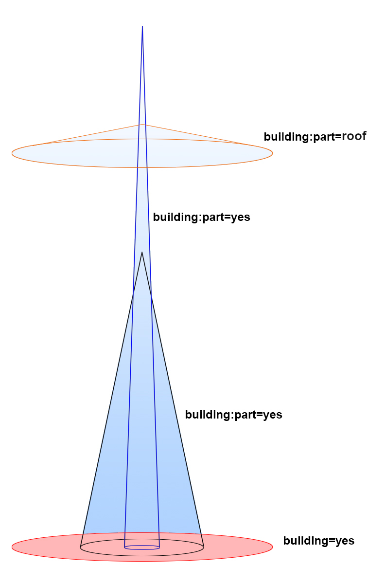
물론 제대로 그리려면 지상부터 맨 위까지 모든 공간이 쓰이고 있는 부분과 그렇지 않은 부분을 나눠서 그려야 하겠으나(층 수가 낮은 부분이나 가운데가 비고 그 위에 쓰이는 공간이 있는 경우 등:지면에서 시작하지 않는 부분을 가진 건물) 모든 건물을 처음부터 그런 식으로 그리기는 어려울 것입니다. 하지만, (OSM에서)’고정된 기둥’과 ‘갖춰진 시설물로써 지붕’이 있는 것을 ‘건물’(building)로 본다 하더라도, 그릴 때는 제 구실을 하는 부분과 ‘큰 기능은 없는’ 부속 부분은 나눠서 그릴 필요가 있을 것 같습니다.

See full entry

Опубликовал Памятку сообществу для картографирования Павловского парка, которую любезно подготовил MosKartograf. Закончил работу над Парадным полем и приступил к самому обширному району парка - Белой Березе.

Posted by INT24h on 20 June 2022 in English. Last updated on 21 August 2022.

I use a few plugins and presets that help me map faster and better with JOSM. I recommend them as basics for people who are starting to map, or even experienced mappers if they find them useful.

Plugins

  • FlatLaf: Dark theme for JOSM across all platforms. This isn’t needed but it makes JOSM way easier on the eyes.
  • Gridify: Generate grids using an area. Very useful for generating parking spaces quickly.
  • OpeningHoursEditor: Visual editor for opening hours
  • utilsplugin2: Adds various tools to JOSM I find useful, personally circle arc is my favorite because it lets you create smoother curves and turns on roads, sidewalks, and the such.
  • easypresets: Create more specific presets of existing presets for faster editing.
  • buildingstools: Draw rectangles quickly. Combine this with Advanced mode on and Create Areas (built into JOSM when Advanced is on) can make adding buildings really, really fast!

Tag Presets

I only use one tag preset called Name Suggestion Index. This allows you to mark businesses with their proper name, wikimedia tag, amenity, etc. This is the same index that iD uses for its suggestions, so this will give you very similar tag presets that iD does. I find this very useful for people moving from iD.