تولید کننده قطعات استراتژیک صنعتی
Users' Diaries
Recent diary entries
Map
Its been crazy trying to edge match to natural water features, adjacent DNR and USFS properties, so I appreciate any help with the alignment problems after public land boundaries have been imported.
I started on the Cadillac FMU of the Pere Marquette- relation/14031776
The Cadillac unit involved lots more crazy edge matching with the Gladwin Unit and Manistee NF units. I also started on the Kirtland’s Warbler Management Area (US Fish & Wildlife Service ownership), relation/14032242, mostly nested within the Gladwin Unit and others. The Seney also has been mangled as I worked to resolve countless shared nodes with a road, so it will need a fresh import from the USFWS open data portal (https://gis-fws.opendata.arcgis.com/) and a relation created as well for the whitefish point area included in the national wildlife refuge.
Interesting to see someone put in Commercial Forest lands, MDNR property tax program enrollment that enables access for hunting and fishing. I am included to do a mass tagging of those already imported with an owner=private, access=permissive, hunting=yes tags. General access is not allowed, only hunting/fishing/trapping access.
As always, I am documenting status at: osm.wiki/Michigan/Parks
Posted by umbraosmbr on 12 April 2022 in Brazilian Portuguese (Português do Brasil).
Mapatona na Cidade de Boa Viagem(CE) Brasil.
Data: 07 de Maio da 2022.
Mapathon in the City of Boa Viagem(CE) Brazil.

Mapatona de Edifícios, Área Verde e Ponto de Interesse em Boa Viagem - CE - Brasil.
https://docs.google.com/forms/d/e/1FAIpQLSeiJNulOSqVGr30TNnB0VSmbKY0DuFS_aAMhMj1R7NO4VtkxA/viewform
Como MAPEAR:
Instruções para o Mapeamento na Cidade de Nanuque/MG. Edificios: Muitos edifícios são muito próximos mas na verdade não se tocam. Tente mapeá-los o mais próximo possível, sem permitir que eles se conectem entre si ou com as ruas.
Caminho para pedestre: Selecione a tag “footway” - caminhos acessíveis apenas a pé.
Área Verde “Mata Nativa ou Relfa”: Selecione a tag “natural=wood” - Para Mata Nativa ou natural=wood para Relfa.
Ponto de Interesse:
Posted by b-unicycling on 11 April 2022 in English.
Last updated on 17 April 2022.
To help me procrastinate from mapping the buildings in Co. Tipperary and because I came across one of them recently, I’ve decided to go on my own pursuit of Diarmuid agus Gráinne on OpenStreetMap. There are a couple of instances on the British War Office map all over the country that are marked as “Dermot & Grania’s Bed”. According to Irish mythology (to cut a very long story short), Grainne made Diarmuid flee with her from her engagement party, and they fled across the whole country, sleeping out in the open (first separate, later not so much).
Throughout history, secretive or mysterious places like caves, dolmens etc have been given that name. The legend is mentioned a couple of times in the Schools Collection on duchas.ie, so that is what I’m using now to track them down, because I cannot search the British War Office map. Unfortunately, I can only read the English texts… But their journey will be trackable, once I am done.
Maybe I’ll get to see one of them at some point.
I’m using the hashtag #Diarmuid&Grainne for my changesets, if anyone wants to check it out. Check for yourself on overpass-turbo. (Thanks, Daniel!)

The state of Texas is locally governed by Counties and not Parishes as in some countries. In Texas, if you see a road designated on the map as Pr 1111, that means Private Road, not Parish road.
The equivalent of a Parish Rd (a road maintained by a local government entity) would be CR 1111 which stands for County Road.
CR roads are often gravel or similar surfaces, especially in rural areas which are not near a major metropolitan area.
I recently published a blog article which serves as a “mega-tutorial” for getting starting an analysis project with OSM data using PostgreSQL and Python.
Check out the full article here: https://travishathaway.com/posts/2022-04-02-processing-osm-data-with-postgresql-and-python/

Cuando hablamos de datos libres y OSM, implícitamente suponemos que cualquier dato que encontremos en Internet lo podemos subir a nuestro mapa. Sin embargo, no es así. Es más, debemos tener varios elementos en cuenta antes de pensar en cargarlos a OpenStreetMap.
Lo primero que debemos entender es que un dato disponible en Internet no necesariamente es libre/abierto. Algunos datos son de dominio público, otros libres y otros son propietarios. Estos últimos son los datos que algunas organizaciones ponen a disponibilidad para solo sus usuarios; no para reutilizarse o hacer obras derivadas.
Con respecto a lo anterior, el concepto de “obra derivada” puede considerarse el hecho de imprimir una parte de un mapa. Esto quiere decir que el mapa ya no solo está disponible en Internet por medio de un visor web, sino que también está impreso en una hoja. Este es el caso de Google, que anteriormente prohibía imprimir parte de sus mapas (aunque ya levantó dicha restricción.) En términos generales, estas son las condiciones de uso que ponen los dueños de los datos, y que son muy restrictivas cuando son datos propietarios. Hay muchos otros ejemplos de obras derivadas, y consisten en basarse en algo existente para hacer algo nuevo (canciones en películas, nuevas canciones con estribillos, etc.)
Entonces, siempre tenemos que revisar la licencia de los datos que vamos a utilizar para mapear en OSM. Si no tiene una licencia explícita, no se deben usar en OSM. Si tiene una licencia, primero hay que ver si es compatible con la licencia de OpenStreetMap, la cual es Open Database License – OdbL 1.0.
It was quite exciting to meet virtually with the new team lead of OyoMappersTeam ,one of the founding team of Unique Mappers OSM Community Nigeria , The team was co-doundaed by Mrs Mary Marcellineus and Victor N.Sunday in 2017. The Team Coordinator, Mrs Mary was also excited to have us discuss ways of breaking barriers to community engagement at Oyo. One of the constraints she is battling is the access to internet connectivity for mapping which is very costly for members to afford . Most often she had to use part of her meager salary ,to ensure, a mapping event or training is hosted . In response, the team was given hope ,that ,such barriers is bound to be overcome as we all work together as a local community NGO for Nigeria -The Unique Mappers ,so we can seek for funding for humanitarian response mapping in Nigeria. If members were up and doing with annual dues/reg ,that would serve effectively to provide internet subscription support for the team but now we can only rely on possible micro grant and donations ,to help us provide sustaining fee internet subscription for mapathon. The team was advised at the moment to get Mi-fire for monthly subscription to hotspot for 32/64 participants or make use of their smartphones. While,Unique Mappers would always be there for the team to provide necessary support. The meeting was as an exciting way to wrap up the day’s activities for OSM volunteering
An appeal to the OSM community and its members!
Russia treacherously attacked Ukraine on 24 February 2022, striking with missiles and bombs at airports, military bases and civilian infrastructure. This was another escalation of hostilities that began in 2014 with the annexation of Crimea and the partial occupation of Donetsk and Luhansk Regions.
On behalf of the OSM Ukraine in connection with Russia’s ongoing military invasion of Ukraine we are turning to people who are contributing to the development and improvement of the OSM data.
We urge everyone to refrain from any mapping of the territory of Ukraine at the moment!
The Russo-Ukrainian War is unfolding on many fronts including the information one. The possible use of open data by Russian invaders to plan attacks on military and civilian objects is one of the most important reasons why we ask you not to perform any mapping of objects in Ukraine.
We shall take action to amend (delete, modify, revert to the previous state etc.) any found cases of mapping related to military or critical social infrastructure facilities as well as contact the DWG and other OSMF working groups to ban the users who systematically make similar changes (more than one).
Such a request (demand) echoes the provisions of the Article 114-2 of the Criminal Code of Ukraine according to which “Dissemination of information on redeployment, movement or location of the Armed Forces of Ukraine or other military formations established in accordance with the laws of Ukraine, if it is possible to identify them on the ground, if such information is not published by the General Staff of the Armed Forces of Ukraine, committed under martial law or state of emergency, shall be punishable by imprisonment for a term of five to eight years” (https://zakon.rada.gov.ua/laws/show/2160-20#n10).
Oyomappersteam executives had an interaction with Uniquemappers team executives on the training they had with Mercy, the Regional Ambassador.
In March 2022, On the International Women’s Day, I presented a talk “Open Mapping Tech for women in Climate Crisis” which gave an insight into what it takes for wonen to participate in mapping by leveraging on some of these applications so that their voices can be heard by the larger society/world. I was able to interact with some women from other countries. The program was anchor by Uniquemappers network Nigeria.
If you want to import OpenStreetMap data to PostgreSQL (+ PostGIS) database two popular tools are osm2pgsql and imposm3.
Both were designed to prepare data for rendering although some time ago osm2pgsql was upgraded with scripting capabilities that go beyond simple mapping files that specify what tables to create and what objects should be inserted there (filter by tags).
There is also osmosis if you want a - more or less - copy of OpenStreetMap database.
imposm3 development was put on hold due to lack of funding while osm2pgsql is actively developed. This makes it questionable choice to use imposm3 but it does have some nice qualities that can make it better for some projects.
In my opinion it’s a very good tool that is useful when:
- you have a webapp and want to use OSM data but Overpass API is too slow/limited
- you want to use OSM data for spatial analysis and keep it updated
** The rest is of the text including instructions how to import data is in my github page: https://ttomasz.github.io/2022-04-08/osm-import-data-with-imposm **

[continued from part 1]
Carrying on with my Brooklyn survey… In the Bushwick neighborhood, I’ve found another new building to map, and a good opportunity to show a little more of NYC’s Building Information Search tool (aka BIS.). Like last time, we’ll start by finding the building’s BIN and height using BIS’s search option 1, with borough Brooklyn, housenumber 618, and street Bushwick Avenue. Here’s the resulting Property Profile Overview page:
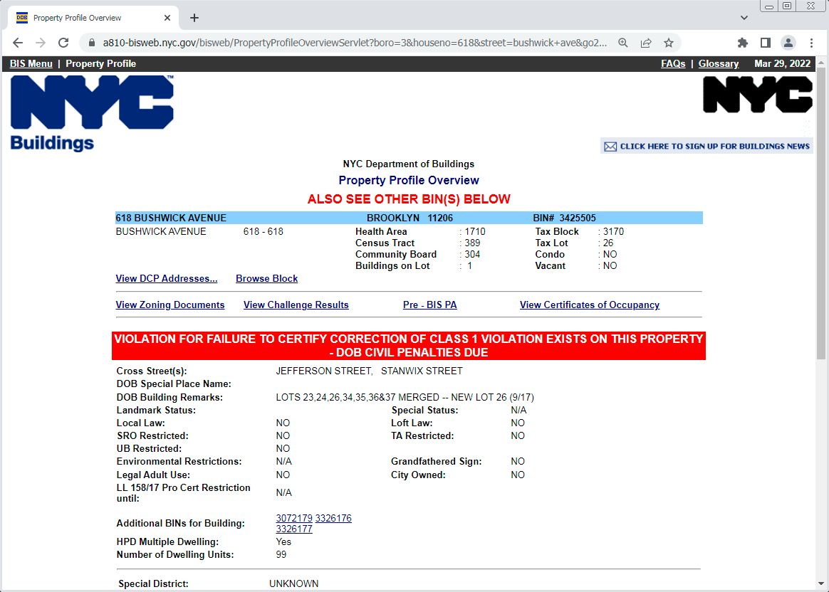
(That exciting red bar means this development is currently in trouble with the Dept of Buildings, but that’s none of my business.) We find the BIN, 3425505. Note the “ALSO SEE OTHER BIN(S) BELOW” message and the “Additional BINs for Building” field – these are older obsolete BINs that this new building has supplanted. The “DOB Building Remarks” note about multiple lots being merged tells the same story, which is a very familiar one in Brooklyn: A large new building has replaced several smaller buildings.
Posted by Pieter Vander Vennet on 8 April 2022 in English.

Hi all,
MapComplete has been (partially) translated in 21 languages by now - an amazing feat that I could never have done alone (for starters, I don’t speak 21 languages).
(For those that don’t know MapComplete - it is an easy-to-use map viewer and map editor. It shows POI on the map and when clicking something, shows the known information and asks questions about it)
Translating MapComplete started by manually editing the translation files, making a pull request, … A next step was moving over to Weblate, where there is more support for translations.
However, one has to know where to find this translations and translating can be tricky, figuring out which piece of text goes where.
That is why I launched a new feature today: toggling ‘translators mode’ (in the copyright tab) will add little buttons, taking you directly to the page to translate the string (or to fix some typos):
![]()
So: please help to translate MapComplete in your favourite language!
Some remarks:
Обращение к сообществу OSM и к его участникам!
Россия вероломно напала на Украину 24 февраля 2022 года, нанося ракетно-бомбовые удары по аэропортам, воинским частям и объектам гражданской инфраструктуры. Это явилось очередной эскалацией военных действий, начавшихся в 2014 году с момента захвата Крыма и частичной оккупации Донецкой и Луганской областей.
Мы, сообщество OSM Украина, в связи с продолжающимся военным вторжением России на территорию Украины обращаемся к людям, которые вносят свой вклад в развитие и улучшение данных OSM.
Мы призываем всех воздержаться от какого-либо маппинга на территории Украины в данный момент!
Российско-украинская война идет на многих фронтах, в том числе и на информационном. Возможное использование российскими захватчиками открытых данных для планирования атак на военные и гражданские объекты является одной из важнейших причин, по которой мы просим не предпринимать каких-либо действий по маппингу объектов на территории Украины.
В случае обнаружения случаев маппинга, касающегося военных объектов или объектов критической социальной инфраструктуры, мы будем их корректировать (удалять, видоизменять, откатывать к предыдущему состоянию и т.д.), а также обращаться в DWG и в другие рабочие группы OSMF для блокирования участников, которые систематически вносят подобные изменения (больше одного).
Такая просьба (требование) перекликается с положениями статьи 114-2 Криминального кодекса Украины, согласно которой “Распространение информации о перемещении, движении или расположении Вооруженных Сил Украины или других образованных в соответствии с законами Украины военных формирований, при возможности их идентификации на местности, если такая информация не размещалась в открытом доступе Генеральным штабом Вооруженных Сил Украины, совершенное в условиях военного или чрезвычайного положения, наказывается лишением свободы на срок от пяти до восьми лет” (https://zakon.rada.gov.ua/laws/show/2160-20#n10).
Hallo Leute, habe schon eine Zeit gesucht und nichts gefunden, möchte einen externen Tracker einbinden, der dann meine Strecke die ich fahre hochlädt, so wäre mein Wunsch, ist sowas möglich. Danke für jede Antwort
Vorwort
In diesem Blog möchte ich ein paar Worte über das Mapping von inoffiziellen Radwegen verlieren. Gemeint sind nicht beschilderte Radverkehrsanlagen (z.B. durch das blaue Schild mit weißen Fahrrad), sondern Wege und abgetrennte oder nicht abgetrennte Bürgersteige besonders außerorts.
Ich bin relativ neu hier in der OSM Community und bin durch eine Projektarbeit zur Kartografierung von Radwegen relativ schnell auf das Problem des Mappings im Allgemeinen und das von Radwegen und Bürgersteigen im Speziellen gestoßen. In diesem Post möchte ich ein paar Gedanken zum Mappping hinsichtlich verschiedener Aspekte aufführen, welche vielleicht die Diskussion bezüglich verschiedener Mappingmethoden in neue Richtungen lenken kann.
Problem
Path
Eine in meiner Umgegend verbreitete Variante, unbeschilderte von Radfahrern vielbefahrene Wege zu labeln, ist “highway=path” mit “foot=designated” und “bicycle=designated”. Dieses Mapping mag zwar akzeptiert sein und die Realität abbilden. Jedoch führt dies in meinen Augen zu einigen Problemen. Zum einen verliert das Label “designated” seine ursprüngliche Bedeutung. Die Alternative mit “bicycle/access=official” scheint mir nur eine umständliche Lösung dazu zu sein.
Außerorts
Ein weiteres Problem besteht darin, dass viele Radwege an urbanen tertiären Straßen verlaufen und damit vom Prinzip her baulich getrennte Bürgersteige sind, welche nicht explizit für Radfahrer freigegeben sind. Dennoch werden solche Wege gut von Radfahrern benutzt, sind in vielen Radkarten zu finden und haben daher teils Radfahrstreifen-ähnliche Kreuzungsmarkierungen. Diese ausschließlich als Bürgersteige zu markieren wäre ein Verlust für das Fahrradnetz, diese aber als “designated” zu bezeichnen ist aufgrund fehlender Beschilderung meiner Meinung nach nicht möglich.
Innerorts und Parks
Bueno, algo he mejorado :)
I am really glad Cad-Man are rendering- WC still seems to have a problem. I did have it as administrative boundary for a bit with the admin_level tag, but I think the admin_level tag was throwing me off- that tag seems to be specific in the US for certain values (=6), regions(=5), etc. Scrubbing the admin_level tag seems to help.
There are still a few national forests kicking around with the boundary=national_park tag to clean up, and there are probably national parks mapped as such that have private inholdings within them not depicted- only the outer boundary is mapped. Case in point, though not a national park, is Adirondack Park- relation/1695394. Adirondack Park is a stretch since there is no national designation for that, unlike National Forests and National Parks. I agree the green line render is a bit much if we used the boundary=national_park tag, and the consensus from the mailing lists seems to be a strict literal interpretation of national “park”, if anything to keep people getting confused- best to stay conservative with the interpretation.
I also made some progress on the Mackinaw State Forest - Gaylord Unit late yesterday and should be done with that one. Then back to fix up the Lake Superior State Forest units. The fix for Tahquamenon Falls State Park seems to be rendering when zoomed in. The Newberry Unit is rendering also- relation/13993909. Shingleton and Sault Ste. Marie still seem to have problems. I would have liked to move on to the Pere Marquette but a little detour to the UP was a nice change.