Tag:footway=chemin_de_ronde
 |
| Description |
|---|
| A chemin de ronde was devised as a walkway allowing guards and defenders to patrol the tops of ramparts, protected from the outside by the battlements or a parapet. |
| Group: highways |
| Used on these elements |
| Requires |
| Implies |
| Useful combination |
| See also |
| Status: proposed |
| Tools for this tag |
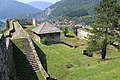
Use footway=chemin_de_ronde alongside highway=footway to represent a ![]() chemin de ronde (French for "round path"' or "patrol path", also known as an "allure", "alure", a "wall-walk", "guard-walk") for traversing a city walls or castle and fortress walls. This path is a raised protected walkway behind a
chemin de ronde (French for "round path"' or "patrol path", also known as an "allure", "alure", a "wall-walk", "guard-walk") for traversing a city walls or castle and fortress walls. This path is a raised protected walkway behind a wall=castle_wall, historic=citywalls, barrier=city_wall ![]() battlement or simple
battlement or simple ![]() parapet.
Today, it is a feature of medieval fortifications of high tourist interest.
parapet.
Today, it is a feature of medieval fortifications of high tourist interest.
How to map
Draw a way and tag it with footway=* and footway=chemin_de_ronde. Accesses could be drawn and tagged as a stairs, entrance, directly or via towers (fortified tower or city gate).
Add footway=chemin_de_ronde and details along the way such as:
Other tags that could be useful in combination include:
bridge=yeswheelchair=*bicycle=*
Examples
-
 Stairs to chemin de ronde along the
 Walls of Dubrovnik
 -
 Great wall of China - very long chemin de ronde
 -
 Chemin de ronde along theWalls of Ston, longest in Europe.
 -
 Chemin de ronde along theJajce Citadel walls
 -
 Castell de l'Aïnsa
 -
 Chemin de ronde (camminamenti di ronda in Italian) Castello Bardi
 -
 Castelo de Numão, Portugal
 -
 Chemin de ronde in Brouage
.jpg)
.jpg)


_-_camminamenti_di_ronda_2_2023-07-04.jpg)
.jpg)

See also
climbing=*- mapping of climbing routesassisted_trail=*