Regina
| V・T・E |
| latitude: 50.4590, longitude: -104.6338 |
| Browse map of Regina 50°27′32.40″ N, 104°38′01.68″ W |
| Edit map |
|
External links:
|
| Use this template for your locality |
Regina is a city in Saskatchewan, Canada at latitude 50°27′32.40″ North, longitude 104°38′01.68″ West.

Background and Local Context
Regina is the capital city of Saskatchewan. It is the largest city by population in Southern Saskatchewan, but is the second largest city in the province behind Saskatoon. It is located on Treaty 4 territory.
Neighbourhoods
Regina OpenData has a map of the 2024 neighbourhoods compared to wards available at this link. It does not include all of the neighbourhoods and local names. As an improvement to this wiki, we should consider publishing an area map with these names.
In local parlance, a few of the areas of Regina are called:
- Downtown: Centre
- Warehouse: Slightly north and east of downtown
- Cathedral: Located south and west of downtown
- The Crescents: south of Cathedral
- North Central: North and west of downtown
- Heritage: South and west of downtown
- Lakeridge: The northern most neighbourhood
- Harbour Landing: The south-west most neighbourhood
- Wascana: The area around the creek
- Dieppe: The settled area in the north that is on the west bank of Wascana Creek
- Uplands: The north-eastern most residential neighbourhood
It is also typical to call neighbourhoods as being in the north end, the east end, or the south end. A running joke in the community is a rivalry between those that live "North of Dewdney" and "South of Dewdney."
Other names of neighbourhoods in the city include:
East Zone
- Dewdney East
- Arcola East
- Boothill
Central Zone
- North Central
- Cathedral
- Downtown
- Centre Square
- Galdmer Park
- Heritage
- Eastview
- Al Ritchie
South Zone
- Lakeview
- Albert Park
- Whitmore Park
- Hillsdale
West Zone
- Twin Lakes
- Walsh Acres
- Sherwood / McCarthy
- Prairie View
- Normanview West
- Normanview
- Regent Park
- Dieppe
- Rosemont / Mount Royal
- McNab
North Zone
- Argyle Park / Englewood
- Uplands
- Coronation Park
- North East
Mapping Status
Ideas:
- list safe needle disposal nodes from: https://www.regina.ca/home-property/safety-emergencies/safe-needle-disposal/
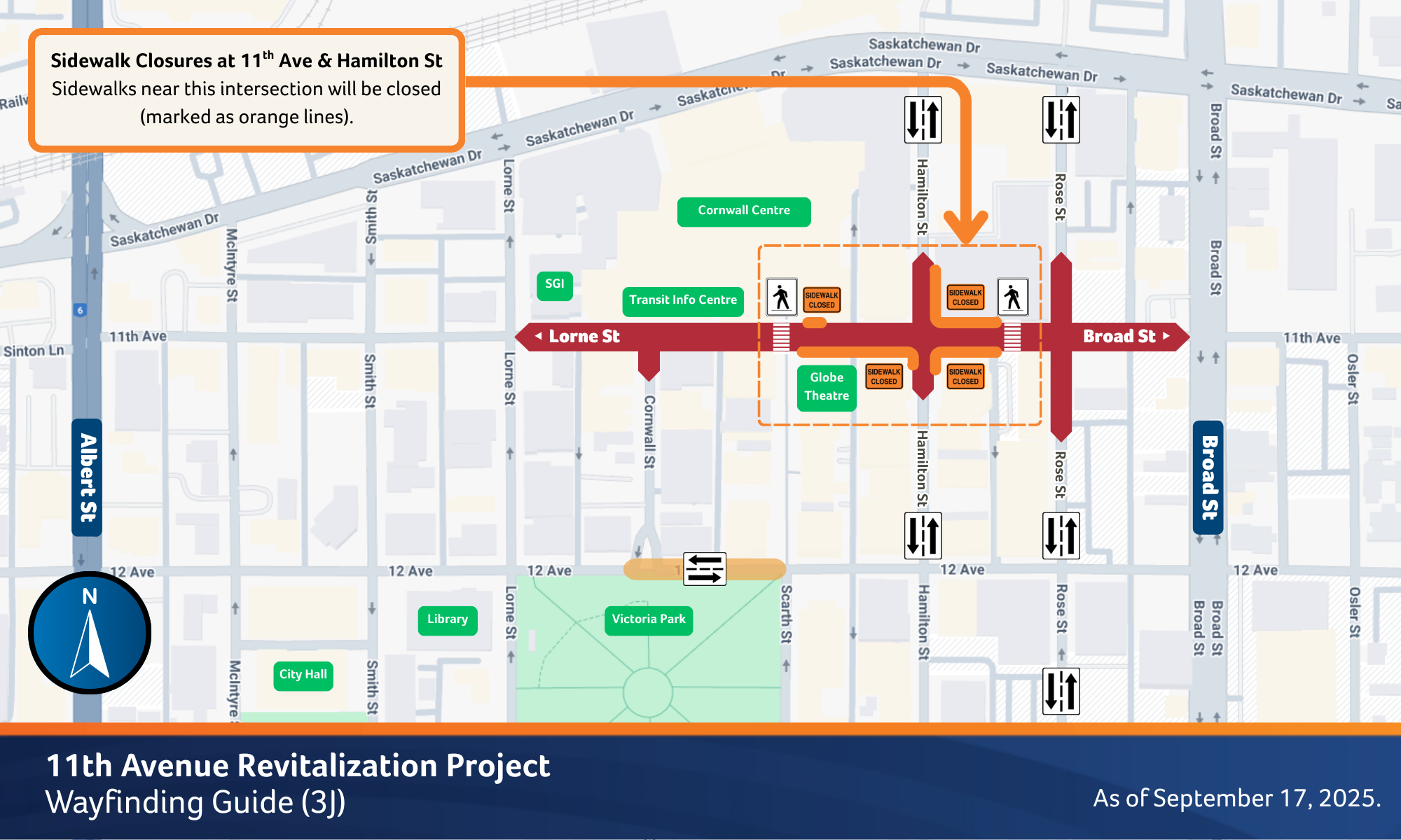
11th Avenue Pedestrian Access Points
11th Avenue in downtown is experiencing a lot of construction and will be until 2026/2027 due to major retrofits. The access points for pedestrians to cross the street seem to be made available regularly (and are visible if you walk in that area). Let's keep an eye on this area and keep making adjustments as they arise. We wouldn't normally map temporary features as per good practice, but some of these adjustments last for months so there is an argument for mapping them with conditional restrictions.
Completed: October 2025: 11th Avenue Construction - Temporary Pedestrian Access Points
11th avenue construction has shifting pedestrian access points. Let's update current conditional points with the one available from https://www.regina.ca/export/sites/Regina.ca/transportation-roads-parking/driving/.galleries/images/11th-Ave-Wayfinding-Sept-17-800x300.png
Status and To-Dos
Access points from October are mapped. Continue monitoring construction and shifting access points.
Update pedestrian points based on newly published corridorsRemove existing pedestrian points as out of date
Downtown Skyways
Skyways in downtown are mapped as lines, when they could be building=bridge (Otherwise, Skyways are used for routing and appear as orphan features while connected between building ways)
Status and To-Dos
Skyways are currently line features. Mapping as areas with appropriate tagging still needs to take place.
- Create a list of skyways needing to be moved.
- Create areas for those skyways.
3D Building Mapping
There are opportunities for improvement in 3d mapping of the city as many buildings in downtown or Wascana are eligible for 3D tagging and would have interesting shapes.
Candidates
- City Hall
- Cornwall Centre
- CanadaLife building
- Mosaic Towers
Brightwater Senior Living Centre in north end(first pass complete 2025-10-11, but could use a check for completebuilding:part=yescoverage + moreroof:shape=skillion)
Status and To-Dos
Some buildings like the Legislative Assembly and some University buildings have building parts mapped already.
List of recurring tasks for 3D building mapping:
- Identify candidates for 3D building mapping
- Publish pictures, sources, or list local knowledge that can aid 3d mapping
- Complete 3D maps for any candidate by referencing Simple 3D Buildings
- Cross off the candidate list as completed
- If you find an existing building with 3D mapping, list it in the candidates list and pre-emptively cross off.
Regina Transit network
As of September 2025, there appear to be some gaps and improvements to be made in the Regina Transit network -- though the overall network seems to be in good status with PTv2.
Several routes have way gaps (not necessarily a problem in PTv2), but some routes have duplicate stops, stops no longer in service, stops that are too far from the routes, or stops on one route that are on both sides of the street. The tag for network should be updated to no longer be "RT" but "Regina Transit"
Beyond surveying, TransitLive (the City's live feed for busing and routes) is a good source of data for making updates to routes.
See the Regina Transit page for details on updates, notes on routes, and overall status.
Status and To-Dos
Currently on-going on the map and on the wiki page.
Items to improve:
- List the relations for each route on the RT wiki page
- List the master relations for each route on the RT wiki page
- Review the relations with Relatify and Osmose for validation problems
Separate Sidewalk Mapping
Almost every road in Regina is mapped accurately with sidewalk:* (kudos to gecho111). There appears to be a mix of sidewalks-as-tags and sidewalks-as-ways in use, especially around the Normanview area.
Mapping sidewalks as ways may be a good idea. If sidewalks were mapped separately, it would allow for accessible routing. It would also make it easy to track distinctions in surface condition between road surfaces and sidewalks (essentially tracking the disparity in how these two are maintained with Regina's very fluid soil.) Discussions about this were had on gecho111's diary, and Malle_Yeno has since then begun the process of separately mapping sidewalks (especially those with a barrier between road and sidewalk).
The goal is to move towards the bronze tier of the PWG's pedestrian navigation schema. Care should be given to crossings and to cycling navigation
Status and To-Dos
Separate sidewalk mapping is underway as of 2025. A project on SimpleTaskManager was created to track this for ![]() Malle_Yeno (on osm, edits, contrib, heatmap, chngset com.), contact them if you would like an invite.
Malle_Yeno (on osm, edits, contrib, heatmap, chngset com.), contact them if you would like an invite.
| Date | Note |
|---|---|
| 2025/08/15 | The Hawkstone area is broadly transitioned to separate ways. I will focus on the north-end for now since that is easily surveyable to me. |
| 2025/09/07 | Malle_Yeno mapped the area around the south-end costco with separate sidewalks, access aisles, and footpaths. |
| 2025/10/03 | According to STM, separate sidewalk mapping for Regina is 1% done! (But Malle made the AOI huge compared to the actual area likely to have sidewalks and there are overlapping segments, so take with a grain of salt. The %done is likely higher. |
| 2025/10/10 | After more sidewalks were mapped and some areas without sidewalks were removed from the list, we're up to 3% complete. |
Indoor Mapping
Candidates for Indoor Mapping
Many malls, lecture theatres, and government buildings could be indoor mapped as they have public directories. Buildings also include fire evacuation maps that could be useful. Some of these resources include:
| Date | Note |
|---|---|
| pre 2025/08/15 | The Regina Public Library - Central Adult Branch in downtown has been indoor mapped (save for escalators that should better be represented as areas instead.) This mapping was based on observations plus the fire evacuation maps posted in the building. There was a complication where the upper floor elevator was drawn inconsistently with the ground floor elevator, so it appeared to shift position and size between floors. The size of nearby rooms had to be compromised to make sure a corridor that was observed in person could be mapped. |
| Pre 2025/10/03 | Cornwall Centre is an excellent candidate for indoor mapping. Malle has been including and adjusting POIs inside the mall, but it is a bit finicky to do it this way with the mall being two stories. With indoor mapping, this can be better addressed. It looks like Cornwall publishes a mall map that could be used here. |
Data Sources
City of Regina Open Data
In August 2025, the LWG approved the compatibility of the City's OGL for use in OSM, which should allow everything offered in the City's Open Data Portal. You can investigate the whole portal for interesting data offerings, but some key ones are listed below.
| Offering | Description |
|---|---|
| Orthogonal Imagery | Aerial imagery of the entire city. Seemingly updated every two years. |
| Oblique imagery | Imagery of the city taken at angles for all cardinal directions. Great for investigating buildings. |
Regina Transit
Regina Transit is the public transit operator in the area. TransitLive is their webapp that shows live bus locations, routes, and detours. They also list fixed routes and schedules on regina.ca.
Mapillary
Some data is available in Mapillary, but it is rather sparse at present. This may improve in the future as Malle_Yeno has started to collect street level imagery through Mapillary in late 2025. There is imagery available from around 2018 along some trails and along the Trans-Canada Highway, but many of the businesses in the City have closed with the pandemic, so be careful about using it for POIs.
Kartaview
A lot of imagery is available on Kartaview, but it is from 2017. Be cautious about using it for POIs, as many businesses closed down over the covid-19 pandemic.
Considerations for the Mapper
Red curb tiles at intersections are not tactile paving

You may notice around the city that there are red pavement tiles that form a ramp into the intersection. Please do not map these as tactile_paving=yes. They do not provide enough information to someone using a long pole about which direction they should walk in.
There are places in the city with half-dome plates, meaning there are legitimate instances of tactile_paving=yes here. Keeping that separation makes it easy to tell whether the ramp can support long pole users.
The "rumble strip" design of the ramps do prevent a long-pole user from walking off the high curb and to navigate them down to the lowered ramp. But from there, there is not enough information about which way to walk based on the pavement. Given that the pedestrian sound signals can be quiet or not work, not enough information about where the other end of the intersection is given to a long pole user.
In summary, please make sure you do not tag red tile curbs at crossings as tactile_paving=yes. If a half-dome plate is installed, then that may qualify as long as it is installed in the correct orientation.
Bike Access
Follow the on-the-ground principle for mapping cycle access where relevant. But if signage or physical access is otherwise unclear, take note that as of 2025, Regina's legislation on where bikes are allowed is not very restrictive. Be careful about tagging motorways you would normally assume bikes to be banned as being so.
For example, SGI's drivers handbook for 2025 asserts that cyclists must not be on Ring Road because it is considered a restricted-access freeway alongside Circle Road in Saskatoon. However, while Saskatoon has a bylaw specifically prohibiting using a bicycle on scheduled freeways, as of September 2025, Regina does not have such a bylaw restricting where cyclists can ride. Regina City Council debated prohibiting bicycles on a section of Ring Road back in 2021, but decided not to proceed with the amendment, which indicates that this omission of restriction is not an oversight.
Also remember that certain restrictions apply to cyclists even on dedicated biking or shared routes. The segments going underneath bridges on the multi-use pathway along Wascana Creek are designated as dismount points for cyclists, for example. That same trail has mandatory stop points for intersections where cyclists might not see incoming pedestrians.
Resources and Shortcuts
Holiday Hour Templates
If you want to point out which specific holidays an establishment may or may not be open for, below are the usual suspects.
| Holiday | Occurs on | Opening Hours Format |
|---|---|---|
| All of them | PH hours_or_Off_here
| |
| Saskatchewan Day (or, Civic Holiday) | First Monday of August | Aug Mo[1] hours_or_Off_here
|
| Canadian Thanksgiving | Second Monday of October | Oct Mon[2] hours_or_off_here
|
| Remembrance Day | November 11 | Nov 11 hours_or_Off_here
|