RU:Key:marker
 |
| Описание |
|---|
| Форма и назначение физического маркера, обозначающего подземные инженерные коммуникации, дорожные километровые столбы или границы частной собственности |
| Группа: Сооружения |
| Используется на элементах |
| Полезные сочетания |
| Статус: одобрено |
| Инструменты |
|
Ключ marker=* используется для обозначения физического маркера, такого как дорожный километровый столб, пограничные метки недвижимости или знаки, указывающие на наличие подземных инженерных сооружений. Значение этого ключа описывает физическую форму самого ориентира.
Маркер зачастую указывает на близость расположенных под землей коммуникационных сооружений, указывает значение расстояния на километровом знаке или обозначает пределы частных земель. Этот ключ позволяет описать форму маркера, а дополнительные теги могут пояснять его функциональное значение.
Как обозначить
Поставьте точку в месте расположения маркера и добавьте marker=* с соответствующим значением из приведённой ниже таблицы.
Основные значения
This list can be completed as needed with equivalent values valuable in other fields of knowledge if needed.

Markers may indicate that a particular linear feature (pipeline, power cable, ...) lies next to it. Nevertheless, markers are installed to be seen and prevent damage at various distances from the feature they refer to. So it's not recommended to put markers directly on pipeline or cable ways, unless the marker is seen fixed on them.
The same could be done on roads or more generally each time markers are not physically placed on what they are supposed to warn or indicate about.
Keep in mind to not add any properties (like diameter=*, pressure=* or voltage=*) that relates to the referring infrastructure on the marker directly. Instead, these properties should be added to the feature which represents the buried infrastructure. You can still add description=* or inscription=* if there is other information on the sign, or a note=* for other mappers.
Additional tags
| Key | Value | Comment | Recommendation |
|---|---|---|---|
marker |
§ Common values | The node corresponds to a marker seen on the ground. | Mandatory |
utility |
gas / oil / power / ...
|
Activity the marker is referring to, if applicable. | Important, if applicable |
material |
wood / stone / metal / ...
|
The material composing most of the marker (referring to the support if dedicated). | Optional |
location
|
underground / overhead / ...
|
The physical location of the marker; e.g. underground, overhead. overground is implied and does not need to be added.
|
Optional |
position |
<left>;<right>;<distance>;<heading>
|
The distance in meters from the marker to the related marked feature, such as a buried cable, pipeline or hydrant, as indicated on the marker. This key should only be filled with values seen on ground, don't use it with approximate values. <left> and <right> describe the horizontal distance you need to move from the marker before heading towards the feature. <distance> is the forward distance in meters to where the marked feature is located behind the marker. <heading> describes the direction the marker is facing in degrees (0–360). It's also possible to use simpler values with following keys: |
Optional |
ref |
<text>
|
If available, the reference number or code which is written on the marker. | Optional |
operator |
<text>
|
The name of the company which operates the marker (and often the associated linear feature, cable or pipeline). | Optional |
colour
|
<RGB code> | <name>
|
The most representative colour of the marker. | Optional |
Other tagging methods
Examples
See examples on individual tag pages such as marker=post, marker=stone, marker=aerial
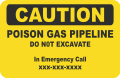
Utility markers in the United States vary widely by operator. Here are the most common form factors: [1][2]
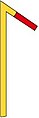
- Most common utility marker form factors in the United States
-

-

-

-

-
-
 Pipeline casing vent:
?


See also
historic=milestone- A historic marker that shows the distance to important destinationshistoric=boundary stone- A historic physical marker that identifies a boundaryboundary=marker- A physical marker that identifies a boundaryhighway=milestone- Stone or metal marker on the side of a road indicating the reference and the distance traveled.railway=milestone- A stone or metal marker along a railway denoting the distance traveled.waterway=milestone- A landmark of stone or metal to indicate the distance traveled along a watercourse.man_made=survey_point- A triangulation pillar, geodetic vertex, or other piece of fixed equipment used by topographers