southglos's Comments
| Changeset | When | Comment |
|---|---|---|
| 77784212 | over 5 years ago | Hiya - quick question. Should "Maze Close" be "Maize Close"? Would fit in with the whole arable farming theme? Thanks for these updates - I occasionally drive down as far as I can with the cameras running to add to Mapillary, but you get a lot further in - on foot, I'm guessing. |
| 82769099 | over 5 years ago | Ok, that's an interesting changeset comment. I'm curious - is there a backstory here? |
| 82755808 | over 5 years ago | Each attribute of an object on the map usually has its own tag, so the fact that it's physically a footpath is recorded as highway=footway, legally it's a public footpath, so that's designation=public_footpath, it has a footpath reference of NORT5, so that's prow_ref=NORT5. If it had a name (e.g. Green Way), that would be name=Green Way. If it doesn't have a name, no name tag. If it were part of a longer path (e.g. Monarch's Way), it would be added to that relation and inherit the route name from that. Probably don't need the "North Wilts" bit, as that can be deduced from looking at council boundaries, but if you really wanted to, you could add an 'operator' tag to name who's responsible for it. Then there are the 'width', 'surface' and 'incline' tags for adding even more detail. And if that's still not enough, there's the 'description' tag for extra detail, and the 'note' tag for extra information for other mappers. Gojng back to the name vs. ref thing, it's the same as how we'd label roads. For example, we don't have name="B4040 High Street (secondary road)", we have highway=secondary, ref=B4040, name=High Street. And similarly, for something with no name, it's not name="M4 motorway", it's highway=motorway, ref=M4, and no name tag. So, for clarity, something like:
It's also good practice to document where the information came from, either as a 'source' tag on the changeset, or on 'source' tags of individual objects if they differ. e.g.: source=survey if you've verified things on the ground. Don't worry that not everything is shown on the map; more specialist stuff such as footpath references can be revealed by using the [↖?] button on the website. Feel free to shout if there's anything I can help with. Happy mapping! |
| 82755808 | over 5 years ago | Hi! Welcome to OpenStreetMap! Thanks for your edits - just a couple of quick pointers, if I may? Firstly, the 'name' field should only be used for the actual name of an object, not references or descriptions. Most likely the path doesn't have an actual name, so it shouldn't have a name tag. There's a tag for footpath references: I'd suggest using prow_ref=NORT5 instead. Some useful info about tagging of UK rights of way on the wiki: osm.wiki/Access_provisions_in_the_United_Kingdom#Public_footpaths Happy mapping! Paul. |
| 82324105 | almost 6 years ago | Thanks for these updates. Minor suggestion - for buildings that have all 90° corners, press [Q] and the editor will square them up for you. Cheers! |
| 81647384 | almost 6 years ago | I love changeset comments like this. The image of a band of merry mappers, valiantly mapping the world one pint at a time :-) |
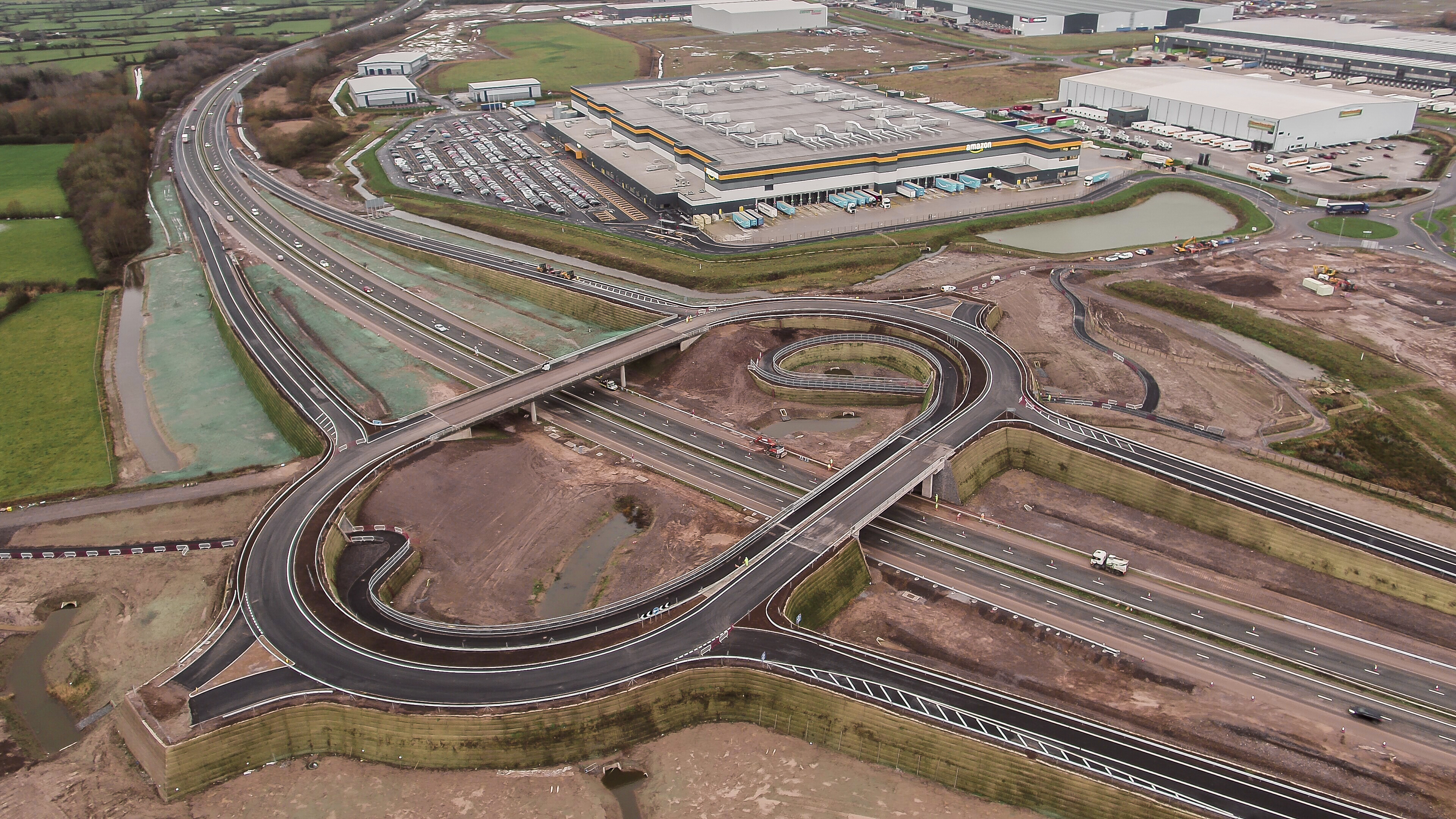
| 81318036 | almost 6 years ago | Here's a nice photo from the Highways Agency: http://assets.highwaysengland.co.uk/roads/road-projects/M49+Avonmouth+Junction/M49+Avonmouth+Junction+December+2019.jpg It shows crash barriers all the way round the edge, blocking off Farm Lane, the unused-for-now stubs to the east, and weirdly, blocking off where it will connect to the distribution park. Perhaps they'll open the junction as a U-turn point before they finish the connecting road. No idea where the footpath we've got coming in from the north-east will go - no sign of anything on that photo, just a 5 metre high wall! |
| 81318036 | almost 6 years ago | Yes, I've left it connected where the cyclepath comes off; I've disconnected it from what's now the roundabout - on the basis that there's a crash barrier in the way. |
| 80079651 | almost 6 years ago | Hiya; me again :-) Thanks for these updates - all appreciated. Hope you don't mind a few comments and pointers? Remember that line features (footpaths, roads, etc) represent the centre line, so generally it's best not to join areas to those lines. For example, it's better if the edge of the wood is off to one side of the footpath slightly (as it was), rather than starting in the centre line of the path. I'll tweak that for you. Cheers,
|
| 80072669 | almost 6 years ago | Hi
|
| 80073259 | almost 6 years ago | Hi
Longs Drive Open Space - you've snipped out an area of leisure=park/landuse=grass and tagged it leisure=park. Is this bit different from the rest of the space? Secondly, you've tagged buildings with name=Workshop etc. The 'name' tag should only be used for the name (of the building itself, or the company if business premises), not for descriptions (there's always the 'description' tag for that). Cheers,
|
| 80073668 | almost 6 years ago | Hi! You've snipped out a bit of Tyndale Primary School and labelled it as a park. From aerial imagery this looks like it's a netball court. So quick question - is this actually a park separate to the school now, is it public netball court (not part of the school), or is it a netball court belonging to the school?
|
| 80000000 | almost 6 years ago | Congratulations on getting changeset number 80000000 :-) |
| 79260663 | almost 6 years ago | That's not what I'm arguing at all. I'm arguing that in OpenStreetMap we don't normally split roads unless they're physically separated. The stretch of road before the exit slip is a single piece of road, with three lanes, with the lane 1 marked up as being for the exit. It's not two separate roadways; there's no physical barrier between lane 1 and lanes 2 & 3. The fact that lane 1 is the lane to be in for the exit slip should be represented with a turn:lanes tag, not by splitting the road into two parallel ways. If you'd advocate splitting roads like this, the correct lane to be in for this exit is actually signed all the way back from half-way down the M4 exit slip, here: https://www.mapillary.com/app/?pKey=kQwq2jnZsbizH0QlpU3w2A&focus=photo - why not split the lane out all the way from here? It would be an unholy mess. I'm not disagreeing that lane 1 is for the exit, I'm not disagreeing with the GPS traces, I'm just saying that the convention in OSM is to split ways based on physical separation, not just on white paint. "How things are on the ground": https://www.mapillary.com/app/?pKey=ztnEcQVRmeVlVdm6EKQFIA&focus=photo - to me, that's a three lane motorway with lane 1 having a different destination to lanes 2 & 3, not two physically separate parallel roads. The turn:lanes tag is for exactly this kind of situation: turn=* |
| 79260663 | almost 6 years ago | A laudable aim, but that's deliberately mis-mapping things for the benefit of satnav prompts. If we start splitting roads whenever we want drivers to get into the correct lane, we'd have an absolute chaos of parallel ways all over the place. You'd not suggest splitting every roundabout approach into multiple separate roads, would you? We should split the road at the point it actually becomes two - I'd say where the solid white line starts just before the physical split (i.e. where it was). The prompts for satnavs should come from a turn:lanes tag on the stretch beforehand. |
| 79260663 | almost 6 years ago | Just noticed this one too. I don't think the southbound carriageway should be split so early - they're not separate parallel roads, it's just one road with lane markings, and it's possible and legal to change between the two halves right up until just before the physical split. I'd be inclined to put the junction back where it was, and tag the run-up to the actual split with turn:lanes=left|through|through |
| 79266553 | almost 6 years ago | I know this has already been reverted, but I can confirm there are "share space" signs on these roads: I'm conflicted on this one. It's not a "home zone", which would be the usual living_street, but it does sort of fit the description in the wiki. I am concerned what having living_street on here would do to routing, though, as this is the main west→east route through the town. One to debate elsewhere, perhaps? |
| 79213373 | almost 6 years ago | Ok, photo is two years old, but if it helps: Looks like surface=paving_stones to me, not a home zone, so not living_street |
| 79211202 | almost 6 years ago | You've upgraded many narrow, single-track lanes to tertiary. Some random examples: By all means pick out any not-quite-B-roads and spine roads through residential areas, but not the single-track lanes, please. Many of the changed roads even had lanes=1 on them already, a sure sign that they're unlikely to be tertiary. I'd prefer a revert rather than having to find and fix all these... |
| 78019896 | about 6 years ago | Bristol City Centre and the new Severn bridge as peak=natural ?? |