
(english translation by OpenAI/chatgpt)
RETEX: Tagging Choices for My Urban Recycling Trekking
Hesitations, discussions, collisions with other contributors, changes, hesitations… but convergence.
to be continued maybe:
- journal entry (upcoming): Existential questions about my encounter with Panoramax
At first, tagging the operator since it’s the target of the trekking.
The operator is known here as GPSEO, or GPS\&O, or Grand Paris Seine and/& Oise… Which name to choose? Likewise, I encountered clothing containers from Le Relais or Emmaüs, and again, which names should be used?
my encounter with Wikidata
Thanks to the forum, I was guided towards Wikidata, which allows assigning a unique code to a large number of resources (companies, operators, municipalities, associations, widely known people, …).
Once the resource in question is given a Wikidata code, its Wikidata entry contains important data (name, website, Wikipedia reference, revenue, …) and thus allows all Wikipedia collaborative applications to access these elements in a common way. So it is enough to reference the operator’s Wikidata code in OSM tags to identify it uniquely and stably. From this code, it’s easy to retrieve the operator’s website, its Wikipedia reference, and other useful information without having to explicitly add them as OSM tags (which would require updating OSM every time the data changes).
A single concession seems necessary: I retrieved the operator’s official name from its Wikidata entry and added it as an OSM tag for readability.
And therefore:
https://wiki.openstreetmap.org/wiki/Tag:operator=GRAND PARIS SEINE ET OISEhttps://wiki.openstreetmap.org/wiki/Tag:operator:wikidata=Q19945071
Tags deliberately omitted because the information is evolving and can be found in the operator’s Wikidata article:
operator:wikipedia, operator:website, operator:short
And similarly:
https://wiki.openstreetmap.org/wiki/Tag:operator=Emmaüshttps://wiki.openstreetmap.org/wiki/Tag:operator:wikidata=Q989437
https://wiki.openstreetmap.org/wiki/Tag:operator=Le Relaishttps://wiki.openstreetmap.org/wiki/Tag:operator:wikidata=Q16654240
ref or operator:ref
Most containers have a metal plate with a reference (or sometimes a painted marking at the base of one side, e.g., for above-ground Le Relais containers).
I hesitated between tagging this value with ref= or with operator:ref.
Again, some exchanges on the forum led me to conclude:
- any reference visible from field inspection deserves to be tagged
https://wiki.openstreetmap.org/wiki/Tag:ref=xxxx. operator:refcan be reserved for the operator’s internal references, which may be the same but not necessarily.
one node per site or one node per container?
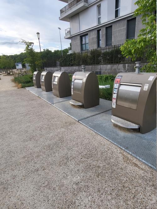 |
I quickly encountered, as is very common, groups of containers (often with underground parts, since public works for them are mutualized). And so the hesitation: |
-
Mapping this as a single point for all five containers:
- Advantages: lighter OSM database, a single node groups all accepted waste types
- Disadvantages: lower precision, impossible to tag individual references
-
Mapping five distinct points:
- Advantages: OSM database perfectly matches the field, independent references for each container
- Disadvantages: heavier database, probably heavier rendering too
-
Mapping as an area:
- Disadvantages: Doesn’t add much and leaves the node issue (none, one, or five?) unresolved
My choice:
- for all fixed containers: one node per container
- for wheeled bins: generally not mapped, since they are temporary or movable elements
- for fixed sites (with hard walls) hosting wheeled bins: one node for the whole site
In OSM, you’ll find both approaches.
amenity= ?
On this tag, there seems to be little difficulty. I only encountered two types:
https://wiki.openstreetmap.org/wiki/Tag:amenity=recycling
which seems to me the normal choice for nearly fixed drop-off points, in container mode.
https://wiki.openstreetmap.org/wiki/Tag:amenity=waste_disposal
which I sometimes encountered but seems unsuitable for containers. This tag describes large wheeled bins, mainly used for collective deposits (companies, residential buildings …). These mobile bins are rarely fixed (they are brought out for collection) and don’t seem to me relevant for mapping. I identified an exception: in some cities, the operator has built fixed enclosures (thus part of the urban landscape) where large bins are accessible for waste deposits, recyclable or not. I chose to tag these with such a node (maybe a way would have been better …).
access= ?
The general case for PAVs (drop-off points) with public access is obviously https://wiki.openstreetmap.org/wiki/Tag:access=yes or simply no access tag.
I also encountered:
- PAVs installed but not yet operational (covered with a black sheet). I chose to map them (since they will soon be operational) with a tag
https://wiki.openstreetmap.org/wiki/Tag:access=noand ahttps://wiki.openstreetmap.org/wiki/Tag:fixme=explanatory note. Maybe I could have usedconstruction. - PAVs reserved for residents of a residential complex. For these, I used
https://wiki.openstreetmap.org/wiki/Tag:access=privateand avoided adding a photo. - PAVs usable with a badge (distributed according to local rules, probably linked to nearby housing). After discussion on the France forum, I decided on
https://wiki.openstreetmap.org/wiki/Tag:access=permit.
location= ?
Containers under 1.20 m in height are all installed in underground pits with a usually metallic cover on which the visible part of the container is fixed. The tag is therefore
https://wiki.openstreetmap.org/wiki/Tag:location=underground
Large containers (about 2 m tall) are usually without underground pits and therefore
https://wiki.openstreetmap.org/wiki/Tag:location=overground
I sometimes hesitated because it is common for these containers to be placed on a base, often concrete but sometimes metal, and at first it was hard for me to distinguish these metallic bases from the covers of pits for semi-underground containers.
wheelchair= ?
I hesitated to use this tag because of the warnings in the Wiki (it normally requires good knowledge of wheelchair accessibility), but drop-off points often either include specific accessibility features or, on the contrary, have designs that make them unsuitable. So:
https://wiki.openstreetmap.org/wiki/Tag:wheelchair=no
- for most large containers, since the deposit hatch is usually high up (to maximize volume).
- for some small containers where the height is not an obstacle but the mechanism seems unsuitable. This is the case for those with a raised foot pedal that must be stepped on to open the hatch. The engineer who designed this probably thought it would free both hands, but clearly did not think about people with lower-limb disabilities.
https://wiki.openstreetmap.org/wiki/Tag:wheelchair=yes
- for large containers when a mid-height opening is explicitly provided for wheelchair users (often with a pictogram). Note: these above-ground containers usually have two sides with deposit hatches, but sometimes only one side has the mid-height hatch (space optimization). Both sides need to be checked before tagging
https://wiki.openstreetmap.org/wiki/Tag:wheelchair=yes. I even saw a container placed against a bridge pier, hiding the accessible side … - for most underground or semi-underground containers, which have hatches accessible to wheelchair users and whose pit covers are generally step-free. (Exception noted above.)
waste types accepted by a container
There is usually little doubt, reading the stickers and signage directly on the containers.
I chose:
glass containers:
https://wiki.openstreetmap.org/wiki/Tag:recycling:glass_bottles=yes
clothing containers:
https://wiki.openstreetmap.org/wiki/Tag:recycling:clothes=yeshttps://wiki.openstreetmap.org/wiki/Tag:recycling:shoes=yeshttps://wiki.openstreetmap.org/wiki/Tag:recycling:textiles=yes
One doubt:
- These containers (at least from the operator Le Relais) also claim to accept “bags.” But I think this means handbags or perhaps shopping bags. The tag
https://wiki.openstreetmap.org/wiki/Tag:recycling:bags=yesseems far too broad (and has no wiki page…). I therefore did not use it.
household waste containers:
https://wiki.openstreetmap.org/wiki/Tag:recycling:waste=yes
Some doubts:
- I had initially tagged
food_wastebut it seemed far too restrictive. - Stickers on the containers also mention diapers, tableware, and small household items. I hesitated to add tags like
recycling:diapers. In the end, I felthttps://wiki.openstreetmap.org/wiki/Tag:recycling:waste=yeswas broad enough.
recyclables containers (yellow bins in France):
https://wiki.openstreetmap.org/wiki/Tag:recycling:beverage_cartons=yeshttps://wiki.openstreetmap.org/wiki/Tag:recycling:cans=yeshttps://wiki.openstreetmap.org/wiki/Tag:recycling:cardboard=yeshttps://wiki.openstreetmap.org/wiki/Tag:recycling:cartons=yeshttps://wiki.openstreetmap.org/wiki/Tag:recycling:paper=yeshttps://wiki.openstreetmap.org/wiki/Tag:recycling:plastic_bottles=yes
In France, packaging waste is now standardized nationwide, and this wiki page raised a few doubts for me:
- maybe I should add
https://wiki.openstreetmap.org/wiki/Tag:recycling:plastic_packaging=yes; - but I was not convinced by
https://wiki.openstreetmap.org/wiki/Tag:recycling:metal_packaging=yes: no wiki page, less than 4000 uses in Taginfo. I preferred to keephttps://wiki.openstreetmap.org/wiki/Tag:recycling:cans=yes. - another possible option (used in Belgium):
https://wiki.openstreetmap.org/wiki/Tag:recycling:pmd=yes
cardboard containers:
https://wiki.openstreetmap.org/wiki/Tag:recycling:cardboard=yeshttps://wiki.openstreetmap.org/wiki/Tag:recycling:cartons=yes
multi-use wheeled bins:
https://wiki.openstreetmap.org/wiki/Tag:amenity=waste_disposalhttps://wiki.openstreetmap.org/wiki/Tag:waste=trash
opening_hours= ?
Drop-off points are outdoors and usually have no opening/closing hours. However, most semi-underground glass containers in my area have a sticker (in red) asking to deposit only between 7:00 and 22:00, clearly for noise reasons.
So I systematically added for these:
https://wiki.openstreetmap.org/wiki/Tag:opening_hours=Mo-Su 07:00-22:00
Note that these stickers are not always present (rarely on above-ground containers, for example) or are sometimes torn off. I chose to tag opening hours only when a visible sticker was present (field survey prevails).
I am aware that the topics addressed here could be discussed (forum? wiki talk pages?) but I am not yet familiar enough to try those tools. For now, this journal entry should simply be seen for what it is: a feedback report.
These RETEX (feedback) entries in my journal reflect my beginner’s choices, hesitations, and questions. They only represent my own practice and are not Wiki pages. Several of these choices were discussed on the France forum, but not all. Of course, I remain open to comments and do not claim to give recommendations here.
Discussion
Comment from Jez Nicholson on 1 September 2025 at 10:56
I don’t know why there isn’t a value ‘amenity=recycling + recycling_type=point’ or similar, to represent a site with a group of containers.
In the UK we call this a ‘Recycling Point’. There will be a number of them dotted around the city. We then have a much larger site called a ‘Household Waste Recycling Centre’ which you might visit via car.
Comment from oldnab on 1 September 2025 at 12:10
Yes, we have the same places : “recycling points” with one to 6 or 7 containers and “recycling centers” you access with car.
My choice (to map each container) is mainly for two reasons :
So one node per container easily allows to manage these two facts.