
Summary Maps of OSMF 2021 Survey Results (Part 2)
Posted by migurski on 26 February 2021 in English.This post is a followup to yesterday’s maps of OSMF 2021 Survey results. We looked at demographics of survey respondents and their feedback to the board on 2020 actions like establishing new committees and fundraising.
I’ll start with a recap of survey respondents vs. the general editing population of OSM. Jennings Anderson also posted yesterday with a view of worldwide mapping behavior and a simple methodology for determining who’s a local mapper for each survey region. This first map shows the number of survey respondents per 1k local OSM mappers, ranging from fewer than 10 in Indonesia and the Middle East to 35+ in Belarus:
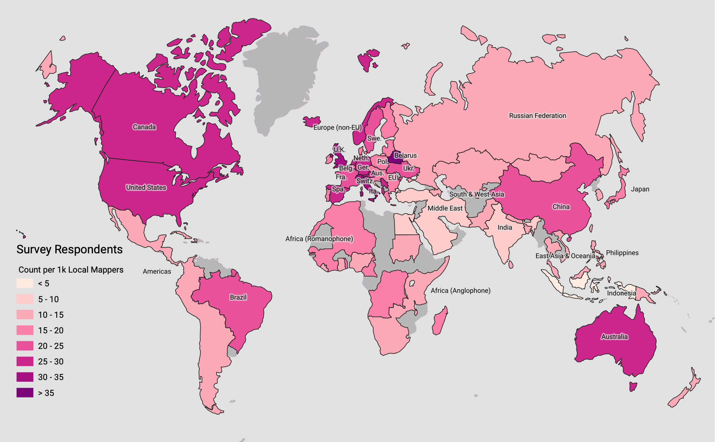
The geographic survey responses are aggregated to preserve anonymity, in some cases grouping dozens of countries under a single region. The maps on this page show simple survey results using the Board’s country-to-region mapping to make the responses easier to interpret. To re-create the map above, and all other maps in this post, source tabular data, region GeoJSON, and a QGIS file are available in a Github gist.
All maps here should be considered “No Rights Reserved,” CC0, or public domain.
2021 Board Priorities
Survey respondents were asked to prioritize the OSMF’s activities in the next year by ranking seven possible tasks in order:
- Stability of the core infrastructure (hardware, software, human capital)
- Outreach to Local Chapters and Communities
- Takeover protection
- Fund-raising
- Recruitment for Working Groups
- Attribution guidelines
- Brexit
The rank order makes this difficult to summarize on a map. Fortunately, the OSMF already elects its board members using a ranked-choice voting system called Scottish Single-Transferable Vote, so I’ve applied that method to the survey responses. I’ve scored priorities for each separate region with one, two, and three possible winning choices to determine overall community sentiment about each of the seven possible choices.
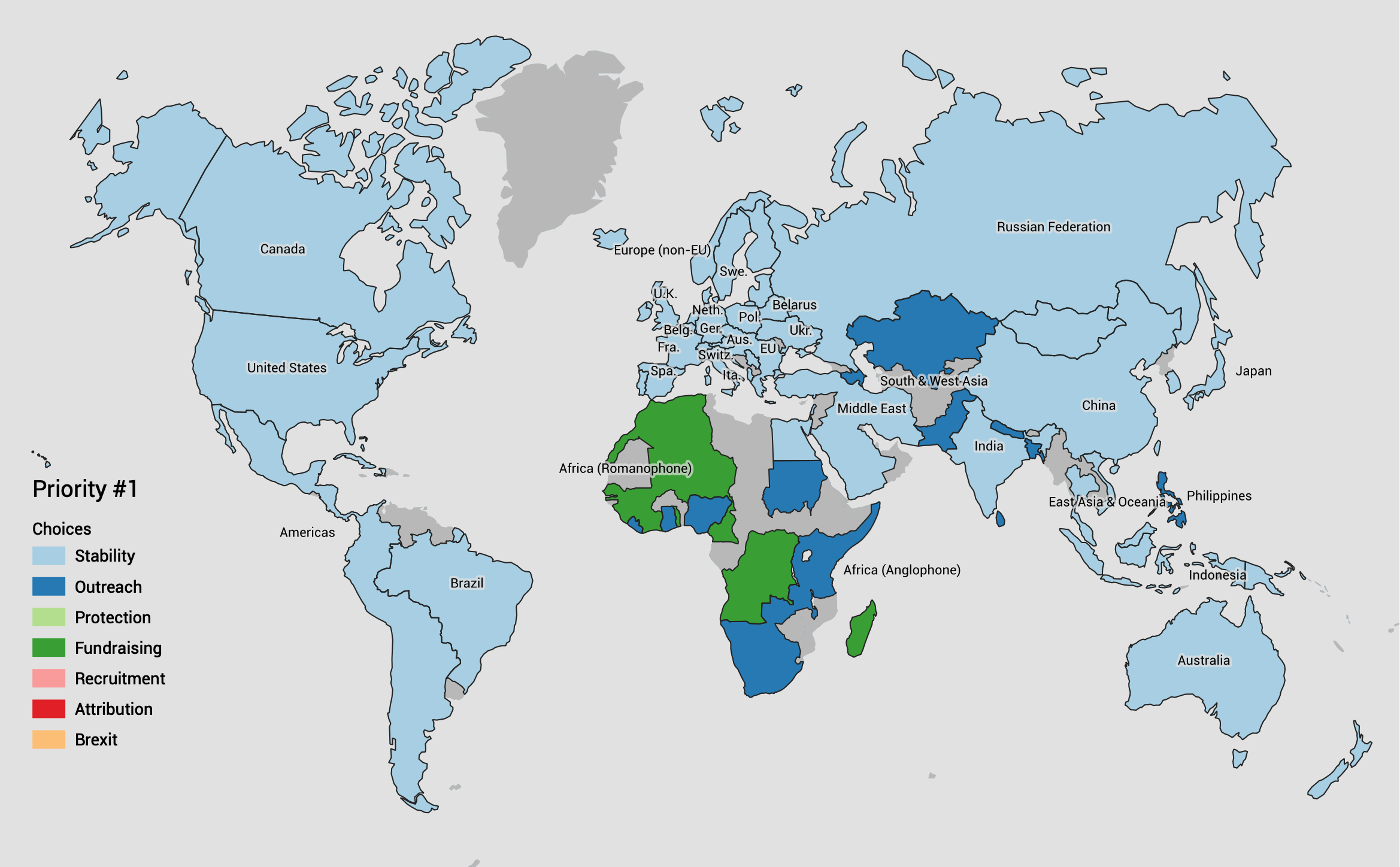
There is clear, strong alignment on core infrastructure stability as the top global priority. Almost all regions chose this as their first priority, and the ones that did not chose it as their second. Stability is a clear winner.
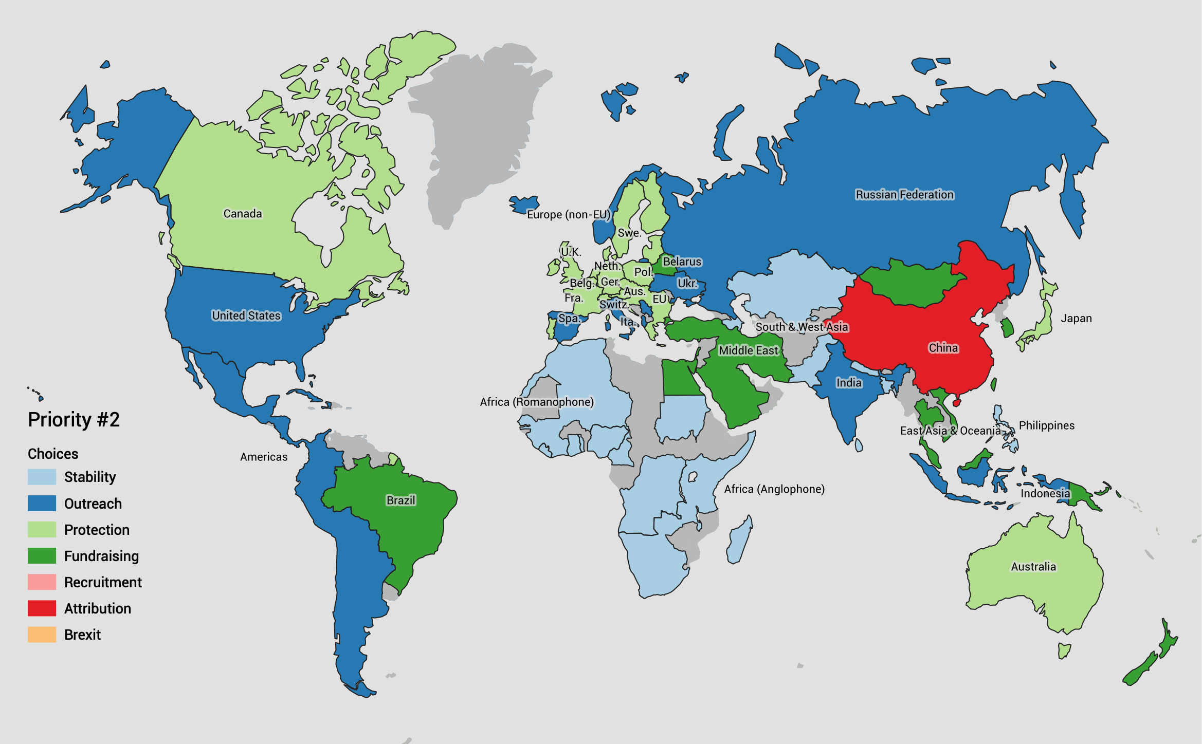
Takeover Protection and Outreach emerge as the next two priorities, approximately neck-and-neck. Protection from hostile takeover of the OSMF is important to European respondents, while outreach to local chapters and communities has a strong showing elsewhere.
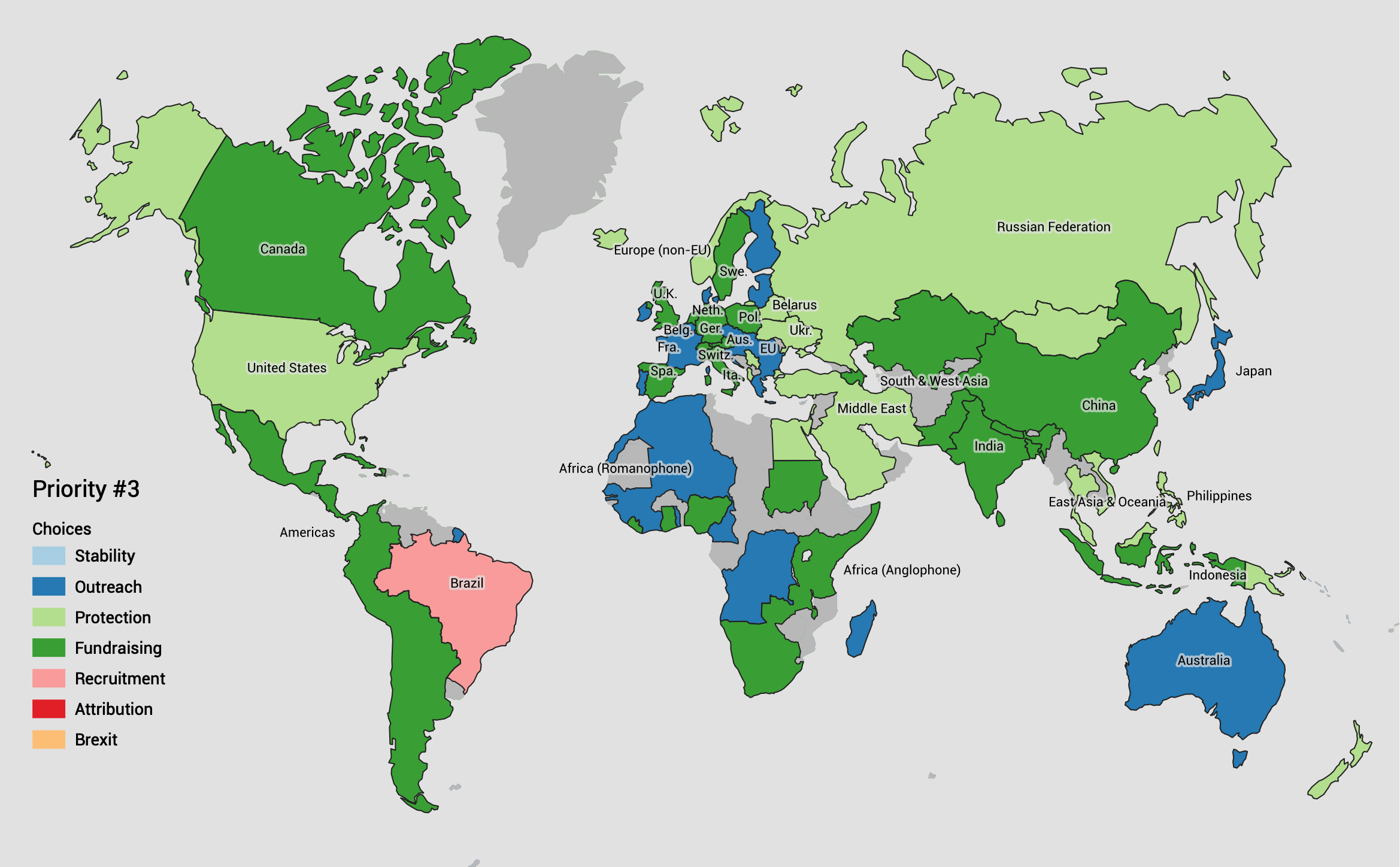
Fund-raising rounds out the top half of the priority list for the board. Working group recruitment and attribution guidelines appear in just one region apiece, and Brexit did not appear important to respondents at all. I interpret this to mean that Brexit-related changes for the UK-based Foundation are an administrative or procedural task that the Board is expected to handle through delegation.
Technology Policy
Survey respondents were asked for their opinion on two hot-button technical issues, AI/ML techniques for expanding the map (sometimes known as “robot mapping”) and a long asked-for vector tiles service to complement the existing OSM.org raster tiles.
Regarding AI/ML, the survey asked for a single response to this question:
Some OSM community members favor use of artificial intelligence and machine learning tools to assist mapping. Others oppose use of these tools. The Board of Directors of the OpenStreetMap Foundation has taken no position on the matter since such a decision would likely violate the core principle that the Board does not tell anyone how to map or what to map. Should the Board…
- “…adopt a policy banning artificial intelligence/machine learning tools?”
- “…continue to take no position (i.e., leave the issue to local communities), since the Foundation tells nobody what or how to map?”
- “…adopt a policy formally approving artificial intelligence/machine learning tools (blanket approval)?”
- “…adopt a policy formally approving artificial intelligence/machine learning tools but only if local communities agree?”
- No opinion
Community responses settled on two leading approaches: continuing to take no position, or formal approval of artificial intelligence/machine learning tools conditionally if local communities agree.

Regarding vector tiles, the survey asked for a single response to this question:
Some OSM community members think the Board should fund change of the map displayed on openstreetmap.org from raster tiles to vector tiles. Bearing in mind the potential cost of such an undertaking, and the possible impact on the OSM ecosystem, in your opinion the Board should…
- “…pay developers to create vector tiles for openstreetmap.org, but in a manner calculated not to compete with commercial developers.”
- “…do nothing in this regard.”
- “…encourage volunteers to create vector tiles for openstreetmap.org, but nothing more.”
- “…pay developers to create vector tiles calculated to demonstrate the full breadth of OSM data.”
- No opinion
Community responses settled on three leading approaches: encouraging volunteers, paying developers to demonstrate full breadth, or not offering an opinion at all.

Conclusion
This post and its predecessor summarized OSMF 2021 Survey responses providing feedback to on past actions and future priorities. If you’d like to dig deeper into the underlying mapping population to put the regional survey results into context, please visit Jennings Anderson’s earlier post with code and data
Source data and files for all the maps above are available in a Github gist, including a GeoJSON file with survey response regions you can use to map official results.
Discussion