ke9tv's Comments
| Changeset | When | Comment |
|---|---|---|
| 108442111 | over 4 years ago | After discussion with @ppjj, did a partial revert to restore High Peaks Wilderness. It appears to have gone without a hiccup. |
| 54875846 | over 4 years ago | Hey, TarasD, I was fixing a broken wetland multipolygon around Duck Hole, and noticed node node/5301451534 showing a ford. Is the bridge out? I haven't been in there for a few years, but when I was there last, there was one https://flickr.com/photos/ke9tv/15353700349/ |
| 108442111 | over 4 years ago | I don't know what you were trying to accomplish with this changeset, but one of the things that you did was to delete the High Peaks Wilderness. Did you intend to do that, and if so, could I trouble you to explain why? Otherwise, could you please revert that part of the change? I don't want to have to redraw that monster. Shoot me a direct message if you need help. I can probably figure out how to do the partial revert of just that part. |
| 106170573 | over 4 years ago | Hi, another Upstate mapper here! I see that you're new in the community, so thanks for joining us, and welcome! It's nice to see outdoor areas getting mapped, so thanks for doing this one. Still, I have a few problems with the way it was done, which made some work for other mappers. First of all, it was mapped with an astonishing number of nodes (at least 3200 of them.) Clearly, the boundaries are mostly straight lines and there's no need for even nearly that many. What's worse is that the high number of nodes suggests that you were in fact importing data from some outside GIS system. Generally speaking, the project doesn't permit that without advance discussion - which is sensible, since one misguided import from the wrong data set could wreck the whole project on a copyright-infringement lawsuit. There was also a completely untagged fragment at the north end of the preserve (across Powderhouse Road). I presume you intended to create a multipolygon to accommodate that, and fixed it accordingly. Also, even with the excessive nodes and the multipolygon topology corrected, there are issues with the data. Your import has the preserve boundary cutting right through houses on the southern margin. There are fence and field lines that appear to have the same general shape, but don't line up, and applying a constant offset doesn't help (enough of a shift to clear the houses moves the northern fragment to the far side of Dibble Road.) Could I ask you to look into the inconsistency, or at least tell me where you got the data? Steuben County has open tax parcel data available at NYSGIS, so if that's not where you got the information, we might be able to use that information to reconstruct this. (It could be that the tax plats are off, as well. When the tax maps were digitized, apparently whoever did it mixed NAD27and NAD83 data willy-nilly so there are significant discrepancies in places.) Anyway, please let me know! |
| 90214355 | over 4 years ago | Thanks for doing these. I had placed a note at Switzkill Farm because I knew the stuff was there. I'm a little surprised that the Long Path doesn't use the trails - it would be nothing to open a few hundred feet of trail along the old stone wall into Cole Hill. That would cut off about a mile of roadwalk. |
| 90304729 | almost 5 years ago | I have some misgivings about the labeling here. In partcular, way way/843528301 is simply not the Shawangunk Ridge according to my understanding. way/843528303 looks all right as far as Roosa Gap, but it veers to the west and follows the divide between the river basins, which is no longer the Shawangunk Ridge. The local naming instead brings the Shawangunk Ridge up through Shawangunk Ridge State Forest (surprise!), and through Sam's Point, MInnewaska State Park, and the Mohonk Preserve down into Rosendale. When climbers talk about going to "the 'Gunks", the Minnewaska area is usually what they mean. The line to the north is part of the Catskill Divide that separates the basins of the Hudson and Delaware. It's a significant ridge and deserves mapping - particularly farther to the north, at least as far as Grand Gorge or Stamford. Beyond that, it would hit an ambiguous flat section. The wetland in Whiting Hollow drains in both directions. A hydrologist could probably work out a dividing line, but I surely can't! The separation between the Shawangunks and Catskills is, of course, indefinite, but pretty much everyone would say that once you're inside the Catskill Park, you're no longer in the Shawangunks. Also, was this import discussed anywhere? I've had major data quality issues with the USFWS wetland inventory farther north; is it any better where you are? I don't recall seeing anything on the 'imports' or 'talk-us' mailing lists about it. |
| 90322319 | about 5 years ago | This changeset appears to have retagged Blue Mountain WIld Forest as 'Essex Chain of Lakes Parking' and made it a parking field. (It also disconnected the multipolygon.) I restored the multipolygon with its correct tagging, but I have no idea what, if anything, you intended to tag as a parking area, so you might want to try to re-enter that piece. |
| 91989785 | about 5 years ago | Mohawk-Hudson bike path is indeed signed to dismount downhill at Blatnick Park. (Nobody obeys the sign.) Sign is visible in https://www.flickr.com/photos/ke9tv/50469749588/ The picture is six months old, but I was there on Saturday and the sign still was up. |
| 25171533 | over 5 years ago | Ahhh. I see it now. It's a water treatment plant. https://patch.com/new-york/bedford/bedfords-new-water-plant-dedicated Which would explain why it's built on protected watershed land. :) Sorry to bother you! |
| 25171533 | over 5 years ago | I see a 'landuse=building_site' (way/301407348) included here. The site appears to be in NYCDEP-owned protected watershed, and so nobody is allowed to build there. Was this entered just because it appears to be a vacant lot? |
| 83996273 | over 5 years ago | I see that in this changeset, you made a modification to the border of Ulster Forest Preserve Detached Parcel (way/431595810). Was that intentional, or did you inadvertently conflate the parcel with the outline of Vly Swamp? I ask because I have new data about the parcel boundary from DEC. If you have better information than DEC's, I don't want to overwrite it! (I never import over another mapper's work without coordinating.) |
| 73515349 | almost 6 years ago | Also, did you grab GPS tracks for the section between Plumley's and Shattuck? I know there have been relocations in the five years since I GPS'ed it, but that area is remote enough that it's hard to make time to get in and update anything. |
| 73515349 | almost 6 years ago | I see addition of 'Ouluska' lean-to that appears to duplicate an existing feature. The separation is within typical GPS error in dense woods. Should these be conflated? |
| 65877530 | almost 6 years ago | Hi. You don't know me, but I've taken an interest in curating the Long Path relation (I've done section hikes on it farther north, and hope to do the whole thing in retirement.) I was looking for something else, and happened to notice that in this changeset you move the SRT down onto Otisville Road/CR61 by Gobbler's Knob rather than a separate way paralleling the road. If this is indeed the case, the Long Path relation also ought to be adjusted, since LP and SRT share treadway in that section. Also, I know that NY/NJ Trail Conference bought a couple of parcels of land east of Wurtsboro village and relocated the trails so that they no longer go through the town. I wonder if you have any data about that relocation? I haven't been down that way in a long time. (Dang, I still have to GPS the relocation in South Berne, NW of Partridge Run. They managed to get the trail off the road, there, too, and that's a lot closer to me.) Feel free to DM me here, or email kevin dot b dot kenny at gmail dot com |
| 34659071 | about 6 years ago | Is it intended to be this building? https://kbk.is-a-geek.net/attachments/20190923/Verizon.png is a snip of orthoimages showing both objects. Should I just get rid of the one in the woods and keep the one that aligns to the building footprint in the aerial images? |
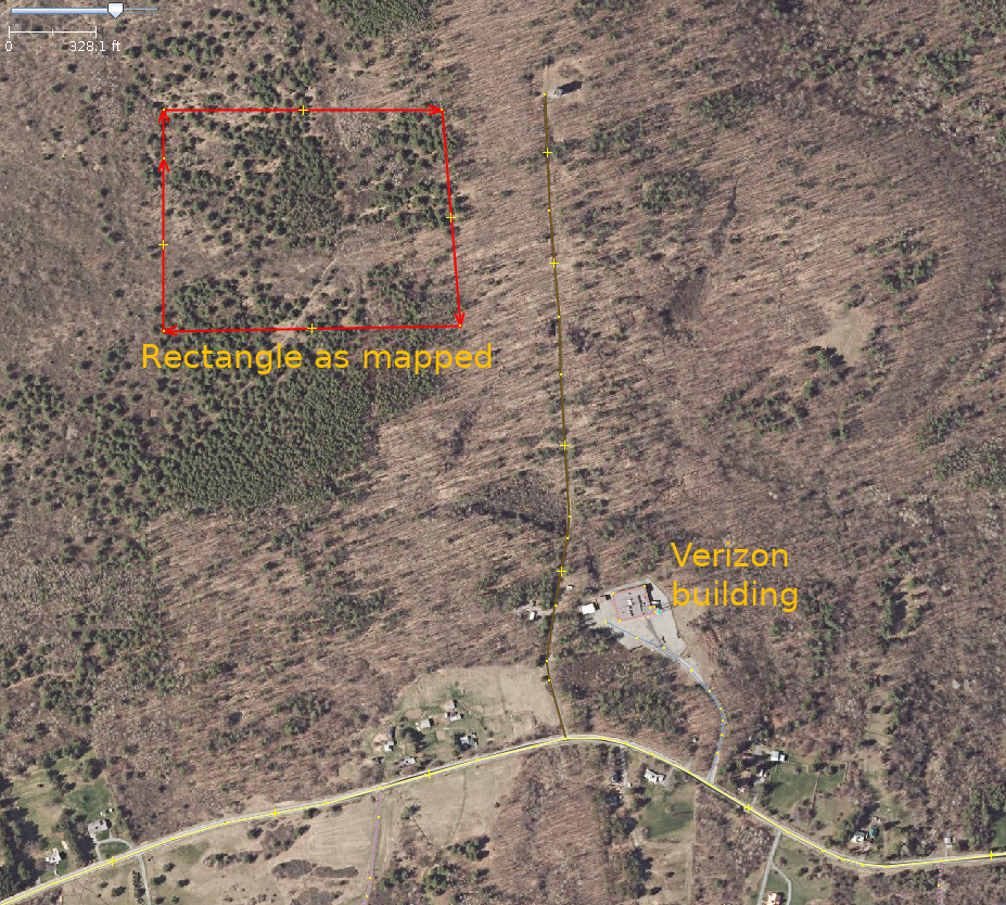
| 34659071 | about 6 years ago | What is this? It seems to be framing an empty patch of woodland, and the relations are untagged. |
| 74277720 | over 6 years ago | Oops. Fixed. |
| 74196565 | over 6 years ago | oops - fixed (Those tags didn't even belong to the tower, they were on a nearby road in a layer that I was using for a visual reference. No idea how they got copied-and-pasted onto the tower.) |
| 50429282 | over 6 years ago | End result is a better boundary for the parks than what was there before it got broken, so it's all good! Sorry for the tone. I was tired, and I've spent too many hours fixing up damage from people who've thought that whatever goverrnment data set they've got is better than what's already in OSM and simply imported over top of things. @ke9tv/diary/42951 is a tiny example of how deep that rabbit hole goes! |
| 50429282 | over 6 years ago | Can the mapper that made this change please explain to me what it was trying to do other than create invalid multipolygons? I can fix the multipolygons (and I want to, because I now have better data available from the state), but I can't make out whether there was some other substantive change that needs to be preserved. There's no comment on the changeset. |