jc86035's Comments
| Changeset | When | Comment |
|---|---|---|
| 61936406 | over 7 years ago | Hello, welcome to OpenStreetMap. I've moved the new object to its correct position and made some other changes (changeset/61938507). |
| 61520682 | over 7 years ago | Thanks. |
| 61463741 | over 7 years ago | Fanling station is in Hong Kong, which means it uses the tagging convention of including both the Chinese name and the English name in name=* (in that order). |
| 61520682 | over 7 years ago | Welcome to OpenStreetMap. Please avoid copying from copyrighted maps without permission (see osm.wiki/Copyright). |
| 60369041 | over 7 years ago | Hi, welcome to OpenStreetMap. Please be aware that imagery is usually misaligned and distorted by a few metres, and this road seems to have already been aligned to GPS data last year (by someone working for Apple). |
| 60381229 | over 7 years ago | I've split the supermarket and the mall. Does the address apply to ac1 or to all of Aberdeen Centre? I've removed the address information for now but you can always add it back. |
| 60381367 | over 7 years ago | Hi, welcome to OpenStreetMap. This is incorrect, because the mall needs to be a separate object, so I've reverted your edit. If you want to add the shopping mall, please add it as a separate object which does not already represent something else. |
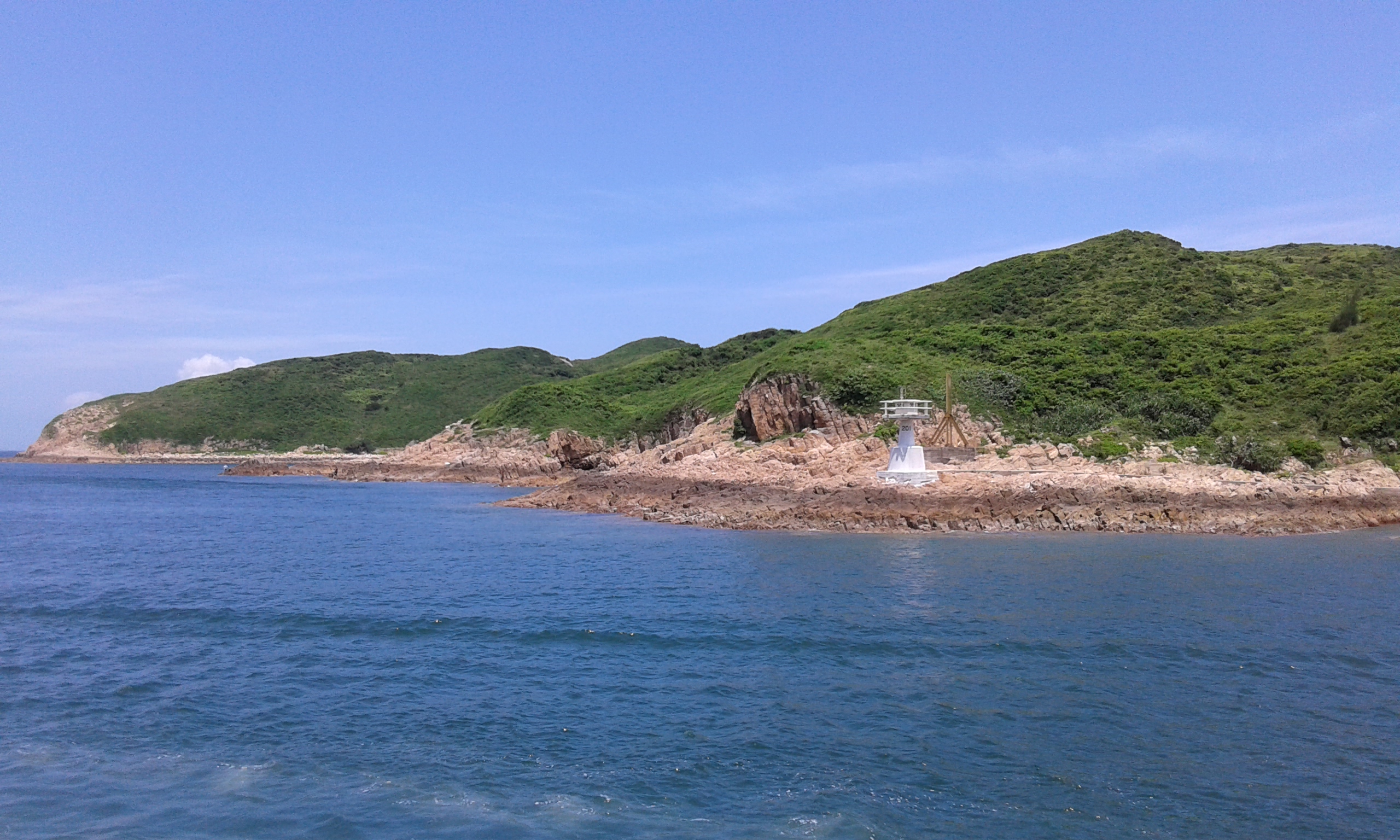
| 59888567 | over 7 years ago | Is this actually a lighthouse? It's not on Wikipedia's list of Hong Kong lighthouses and the image in the island's Wikipedia article (https://upload.wikimedia.org/wikipedia/commons/5/51/Town_Island_%2814%29.jpg) shows it as being only a few metres tall. |
| 57087753 | over 7 years ago | I've removed the park tagging for these two objects, since they do not appear to have been designated yet. |
| 56776517 | over 7 years ago | He also seems to have duplicated stations in Vancouver and Beijing (and probably elsewhere). Maybe an email should be sent to the mailing list or something? |
| 56776517 | over 7 years ago | cantor34 also edited a lot of other stations (I reverted his edit on Fanling station). Admiralty station currently has an "Island Line" relation and a "South Island Line" relation created by him, both part of the same parent relation. One or two of those should be deleted at some point. |
| 56776517 | over 7 years ago | The building=train_station issue is https://github.com/gravitystorm/openstreetmap-carto/issues/2504. I think if you were to delete the extra nodes and use JOSM to revert the station areas to what they were before cantor34's edits (and merge the relations at Admiralty station) then you could fix it for now. |
| 56776517 | over 7 years ago | @freayd, cantor34 is unlikely to respond to the changeset comments, since they have had three months to do so. I don't know if there is a standardized method of tagging for metro station outlines. building=railway_station (e.g. Sai Ying Pun) currently renders incorrectly in Mapnik by covering all the other buildings, and railway=station (e.g. HKU) appears to set landuse for the entire outline unless building=yes is used. I don't know if it is appropriate to use a building=* tag for a fully underground structure, and it was suggested to me once that the tunnels should only be mapped as highway=footway (e.g. East Tsim Sha Tsui). For what it's worth, the completely-mapped set of underground stations in Moscow uses the highway=footway model. The MTR has fairly large underground concourses so I don't know if it would be totally appropriate, but I think it would be good to draw the footway and escalator/lift networks in any case, since they definitely exist and can be mapped. |
| 58817583 | over 7 years ago | I would suggest using JOSM to make the relations instead of iD, since with JOSM you can download all of the railway elements in HK with the built-in overpass turbo search and select large numbers of objects more easily. |
| 58817583 | over 7 years ago | Rather than adding the Wikidata tag to every child relation, I think it would be preferable to create separate relations with route=railway ("These relations gather rail infrastructure (track) elements"). This would also avoid highlighting all the platform outlines (although I'm not entirely sure if those relations are supposed to contain just tracks or all of the infrastructure). |
| 58746871 | over 7 years ago | Hi, welcome to OpenStreetMap. If something isn't actually signposted as having a real name, then you shouldn't add an unofficial descriptive name (never add names you made up yourself). I find it unlikely that a playground in HK would be officially called a "kid playground" in English (rather than, say, a "children's playground" or just a "playground"). You should add names in both Chinese and English in Hong Kong, per tagging convention (see the OpenStreetMap Wiki). |
| 58504875 | over 7 years ago | Hi, please don't trace from HK government maps, since they are copyrighted. It's better (and less legally tenuous) to use satellite imagery, although in this case your best option is probably to make an informed guess. |
| 57985948 | over 7 years ago | Hi and welcome to OpenStreetMap. (I've fixed your addition since you tagged the object as a motorway instead of as a building.) |
| 57877869 | over 7 years ago | Welcome to OpenStreetMap. Please don't add roads over existing roads; if you think the tagging of a road is incorrect and should be changed, just change the tag on the existing object. Also, please don't connect buildings to adjacent roads. The iD editor might do this automatically (especially where data is denser), so be careful about this. |
| 57876088 | over 7 years ago | Welcome to OpenStreetMap. Please don't add name labels like "House"/"hOUSE" unless objects are actually signposted or named as such. |