
Mapping Changing Street-Names in Nottingham City :: 1800 to 1899
Posted by alexkemp on 2 November 2022 in English. Last updated on 4 December 2022.- Foreword + Summary
- Details:– Early to 1199
- Details:– 1200 to 1399
- Details:– 1400 to 1599
- Details:– 1600 to 1799
26 November 2022
The last page in this sequence of diary entries used to be “1800 to current”. It became so large as to become unreasonable, so I have broken it up into two pages: the original first half is now “1800 to 1899” (this page), whilst the second is now 1900 to current.
Details:– 1800 to 1899
- 1800 July 2: Twin Acts of Union are enacted by the Parliaments of Great Britain and of Ireland to create the United Kingdom of Great Britain and Ireland (this was all of Ireland; previously the union was a Personal Union due to having the same monarch — see 1541). These Acts came into force on 1 January 1801, and the 1ˢᵗ joint Parliament was on 22 January 1801.
This was the moment when the modern UK Flag came into being (used as a “Union Jack” on UK ships). It is the 1707 Great Britain flag united with the red saltire of Ireland. Interestingly, the GB flag is symmetrical, whilst the UK flag is not (meaning that it should NOT be hung upside-down nor reversed).
| Flag of GB: |  |
| Flag of Kingdom of Ireland: |  |
| Flag of UK: |  |
- 1800s early:
- Start Date for [Garden buildings and adjoining boundary wall at Castle Museum (part of the Castle Grounds) (Grade Ⅱ listed)].
- Start Date for [Wyville House 2 Castle Place (Grade Ⅱ listed)], [70+72 Hounds Gate (Grade Ⅱ listed)].
- Start Date for [Old Rectory + Coach House, Village Road, Clifton (both Grade Ⅱ listed), plus the Boundary Wall & Railings (also Grade Ⅱ listed)]. The Rectory was derelict but has now been totally rebuilt (though zero imagery).
- 1807
- St James’ Church founded on Standard Hill (see St Peter with St James Church); described by it’s incumbent as ‘a plain if not to say ugly church’ it was designed as the parish church for The Park & was opened in 1809.
- 1809
- First domestic building in The Park is built (St Mary’s Vicarage + St Peter’s Rectory (Grade Ⅱ listed)).
- The Park Passage is cut through the old outer moat of the Castle, near the Gatehouse, into The Park (see The Park (pdf) Conservation Plan).
- 1810
- Mount Street: a rename of the former Bearward Lane. One of the city’s oldest streets, it got that old name due to being a scene of bear-baiting (finally outlawed in England in 1849).
- 1811
- Luddites began their activities in Nottingham.
- 1818
- 28 September: A canal warehouse near Wilford Street was destroyed, and either 2 people or 16 men & boys died when a man named Musson decided to drop a hot cinder onto a little spilt gunpowder. 21 x 100lb (45kg each, 953kg total) barrels of gunpowder were in transit from Gainsborough for use in the Derbyshire mines, and had been delivered by The Nottingham Boat Company via the Trent. Boats were destroyed, buildings damaged, and Musson discovered the temporary joy of 126 yards (115m) of aerial flight. The insurance company refused to payout & the Boat Company pled poverty after being successfully sued & told to pay $1,000 + costs (equivalent to $60,000 in 2022).
- 1819
- April 14: Gas-lit streets arrive (they have never left The Park).
- 1820
- The Navigation Inn was used as a terminus for a canal-Ferry to Leicester, according to the council Conservation pdf.
- New communities spring up in New Radford, New Lenton, New Basford, Hyson Green & Carrington (these outside of the town boundary).
- 1825
- Architect Peter Frederick Robinson engaged by 4ᵗʰ Duke of Newcastle re: The Park.
- September 27: First permanent steam locomotive public railway opens between Stockton & Darlington (26 miles | 42 km).
A very interesting history of the SDR is here. Sadly zero mapping, although GIS is available (reported here, though I could not find it).
The Etherley Ridge Stationary Engine pull is still there; see Phoenix Row (beginning), Etherley Incline 1, Etherley Incline 2, Etherley Incline 3 which then gets to West Auckland & Station Road. The entire length of the original line is mapped here.
- 1827
- Homes built at The Ropewalk: [32, 32a Oak Hill House (Grade Ⅱ listed)] [34 The Townhouse (Grade Ⅱ listed)] [36a 36 38 (Grade Ⅱ listed)] [40 (Grade Ⅱ listed)]
- PF Robinson published his ‘Plan for Nottingham Park’; it was impractical for The Park & was never developed.
- PF Robinson built Park Row: [53 Tower House (Grade Ⅱ listed)]
- PF Robinson built Park Terrace (one of the Estate’s gated streets): [1 (Grade Ⅱ listed)] [2 (Grade Ⅱ listed)] [3 (Grade Ⅱ listed)] [4 (Grade Ⅱ listed)] [5 (Grade Ⅱ listed)] [6 (Grade Ⅱ listed)] [7 (Grade Ⅱ listed)] [8 (Grade Ⅱ listed)] [9 (Grade Ⅱ listed)] [10 (Grade Ⅱ listed)] [11 (Grade Ⅱ listed)] [12 (Grade Ⅱ listed)] [15 (Grade Ⅱ listed)] [16 (Grade Ⅱ listed)] [17 (Grade Ⅱ listed)] (all completed 1833); there are in addition 5 Grade Ⅱ listed constructions clustered around #14A: [Garden Summerhouse] [Herbarium Cave] [Steps Cave] [Daniel’s Cave / Haddon Hall Stairs] [Summerhouse Cave].
- 1828
- PF Robinson-designed homes built on Park Valley: [8 + 10 (both Grade Ⅱ listed, completed 1829)].
- 1829
- April 10: William Booth, founder of the Salvation Army, is born in Sneinton.
- PF Robinson built Derby Terrace, a splendid stuccoed terraced block of houses (all Grade Ⅱ listed: [Lacemakers House][2-7][8-9]); The Park Passage + Park Steps enlarged.
- 1831
- 1ˢᵗ continuous, pressurised, filtered-water supply provided in the country in Nottingham. As the supply is extended in scope the incidence of Cholera in the town reduced, until in 1848 (a 2ⁿᵈ outbreak) there are zero fatalities.
- North Road established.
- The townsfolk were upset at the growing loss of recreation in The Park due to the 4ᵗʰ Duke’s plans & actual building. However, the deeper issue was political corruption.
The entire nation had changed radically, but politics & Parliament had not:– - only 5% of the British populace were able to cast a vote at a general election
- some new urban centres had no MPs at all (eg Manchester)
- many political constituencies were rotten boroughs (literally bought & sold)
- March: The Whigs under PM Earl Grey were in favour of political reform, whilst the Conservatives (‘Tories’) under the Duke of Wellington were agin’ it. Grey introduced a Reform Bill. It was defeated by the Tories, so Grey resigned & was re-elected with a majority.
- Oct 8: A 2ⁿᵈ Reform Act passed in the Commons but was defeated in the House of Lords.
- Oct 10: The 4ᵗʰ Duke of Newcastle was one of those that voted against the Great Reform Bill in the Lords. The Nottingham population erupted in full-scale riots (also in Bristol and Derby), and the Castle (empty at that moment) was trashed & burned. Scots Greys cavalry were deployed in Birmingham. Serious disturbances were reported in London, Leicester, Yeovil, Sherborne, Exeter, Bath and Worcester.
- 1832
- Between 40 & 50 houses had been built so far within The Park by Robinson for the Duke.
- Jan: 26 Nottingham men were tried for the 1831 riots, 8 were found guilty and 3 were hanged.
- May: Grey resigned & Wellington tried, but could not form a government. Grey was recalled by King William Ⅳ and passed a Third Reform Bill. The King now threatened to flood the Lords with new Whig peers. The Tories abstained & the measure now passed.
- June 7: The Great Reform Act was passed into law.
- August: The 4ᵗʰ Duke was awarded £21,000 in damages (equivalent to £1.7m in 2022) re: his burnt-out Castle during the Reform riots of October 1831. He took the money, but refused to repair the Castle and left it as a burnt-out shell. In a further fit of pique, this petulant child suspended all building work in Nottingham.
- 1ˢᵗ UK Cholera Epidemic killed so many townsfolk that all town cemeteries were filled.
- 1834
- Surveyor George Sanderson, of Mansfield, drew the circular map “Twenty Miles Round Mansfield” in 1834 & 1835.
- 1835
- Samuel Fox donated land just outside the town boundary to establish St. Ann’s Cemetery, known to the townsfolk as the Cholera Cemetery (and now as St. Mary’s Rest Garden).
- Parliament enacts the Municipal Corporation Act. The 1832 Reform Act had reformed parliamentary constituencies; this Act was designed to correct corruption within Municipal Corporations. It provided for specific changes to 178 named boroughs. In Nottingham’s case it superseded the 1449 charter. As just one clause, each of these boroughs was required to setup paid police forces.
- Homes built on Park Valley: [4 Hollyhurst (completed 1845)] [6 Stuart Cottage (completed 1845)].
- 1836
- Nottingham City Police first founded as “Borough of Nottingham Police” under the auspices of the 1835 Act. It consisted of 15 men working under the existing High Constable William Barnes. It failed miserably after 5 years due to “internal rivalries … and general incompetence”. Re-launched in 1841.
- 1837
- June 20: Victoria, the last British monarch of the House of Hanover, is crowned Queen of the United Kingdom, the Crown Dependencies and the British Overseas Territories. In her lifetime she became monarch of the Empire on which the Sun Never Sets.
- 1838
- PF Robinson-designed homes built on Park Valley: [15 (Grade Ⅱ listed, completed 1839)] [17, 19 (both Grade Ⅱ listed, completed 1839)] [21, 23 (both Grade Ⅱ listed, completed 1839)].
- 1839
- Inclosure of Lammas Fields (Wellington Circus), Burton Leys (centred on Trinity Square & Burton Street) and West Croft (put simply, this was the area to the west of the modern Eastcroft Depot; see also the council Station Conservation plan (pdf)).
- Midland Railway (MR) open a station terminus in the town west of Carrington Street; the town council extended Carrington Street to the south to link up with the station + constructed Station Street to link the station with London Road. A spur was constructed from the canal to linkup with the Goods Yard. A brick humpback bridge remains, carrying the towpath over the beginning of the spur.
- An almost-pointless Westcroft Canal was cut, running from the existing Nottingham Canal just east of Carrington Street and running due south under the rail-lines, then turning east halfway between Station Street & the future Queen’s Road (see 1843) it re-joined the Trent Canal. It served some coal wharves, but the railway dealt it a quick deathblow in 1869.
- A parliament Standing Order decrees that all future Inclosure bills must make provision for open spaces for recreation.
- 1840
- Victoria marries her 1ˢᵗ cousin Prince Albert of Saxe-Coburg and Gotha.
Marrying close family is a profoundly bad idea for the health of your children & descendants. At this point almost all of the royal families of Europe & Scandinavia were closely-related to each other, and this marriage led (as only one example) to haemophilia spreading amongst European royalty. - PF Robinson-designed homes built on Western Terrace: [11 Lincoln Villa].
- New Road (a toll road) laid out, linking St. Ann’s to Mapperley; now called Ranson Road.
- Victoria marries her 1ˢᵗ cousin Prince Albert of Saxe-Coburg and Gotha.
- 1842
- Nottingham Independent Cottage Garden Society petitioned the Corporation for allotment gardens; these were supplied from land owned by the Bridge Estate (see 1302 + 1551).
- 1843
- St. John the Baptist Church founded on Leenside as the parish of the The Marshes (Broad Marsh, Middle Marsh and Narrow Marsh); (Leen Side was cleared in the 1930s; the Church was located north of the modern Canal Street, approx. where Shortwood Close is today). It was consecrated in 1844. It soon had a regular congregation of 1,600.
- Monday 4 December: Queen Victoria and Prince Consort passed over Heth Beth Bridge (see 920) in their progress from Nottingham railway station to Belvoir Castle, which accounts for the Royal Arms being displayed upon the present bridge in memory of that occasion (reported in Notts History, but the date there is wrong, see Queen Victoria’s Journals); Queen’s Road was constructed on that very day especially for the visit — see Notts History.
- 1844
- Reported in this MSS webpage are the words of the water engineer Thomas Hawksley speaking to a Royal Commission in 1844, p136:–
- “Of the death rate in Nottingham, which was 25 percent above the national average, he commented that the average age at death amongst males was only 20.5 years, although ‘the situation of the town is decidedly salubrious, and the occupations of the people not necessarily unhealthy”
- Tunnelling on the Park Tunnel, along the same route as indicated on Robinson’s earlier plan, stopped (half the route had been excavated at the point that it was abandoned).
- TC Hine-designed homes built on Western Terrace: [7 + 8;9 Huntingdon House + 10 (Grade Ⅱ listed)].
- Reported in this MSS webpage are the words of the water engineer Thomas Hawksley speaking to a Royal Commission in 1844, p136:–
- 1845
- June 30: Royal Assent given to the Nottingham Inclosure Act (pdf); this affects the 2 large adjoining fields of Sand Field & Clay Field to the north, plus the large, low-lying Meadows to the south; 3 Commissioners were appointed.
- The Nottingham Review (newspaper) + Whigs (political party) are pro-Enclosure
- The Nottingham Journal (newspaper) + Conservatives (political party) wanted an Improvement Act (rather than an Inclosure) to fix the roads & Sanitation
- Aug 1: the Inclosure Commissioners appoint an Umpire, a Clerk, an Official Referee, plus their Bankers.
- Aug 20: 2 of the 3 Inclosure Commissioners resign.
- Dec 29: the Inclosure Umpire dies.
- TC Hine-designed homes built on Park Valley: [5 (completed 1850)] [9 (completed 1850)] [11].
- TC Hine-designed homes built on Western Terrace: [3 + 4 (Grade Ⅱ listed)] [5 + 6 (Grade Ⅱ listed)].
- 1846
- Albert Street built.
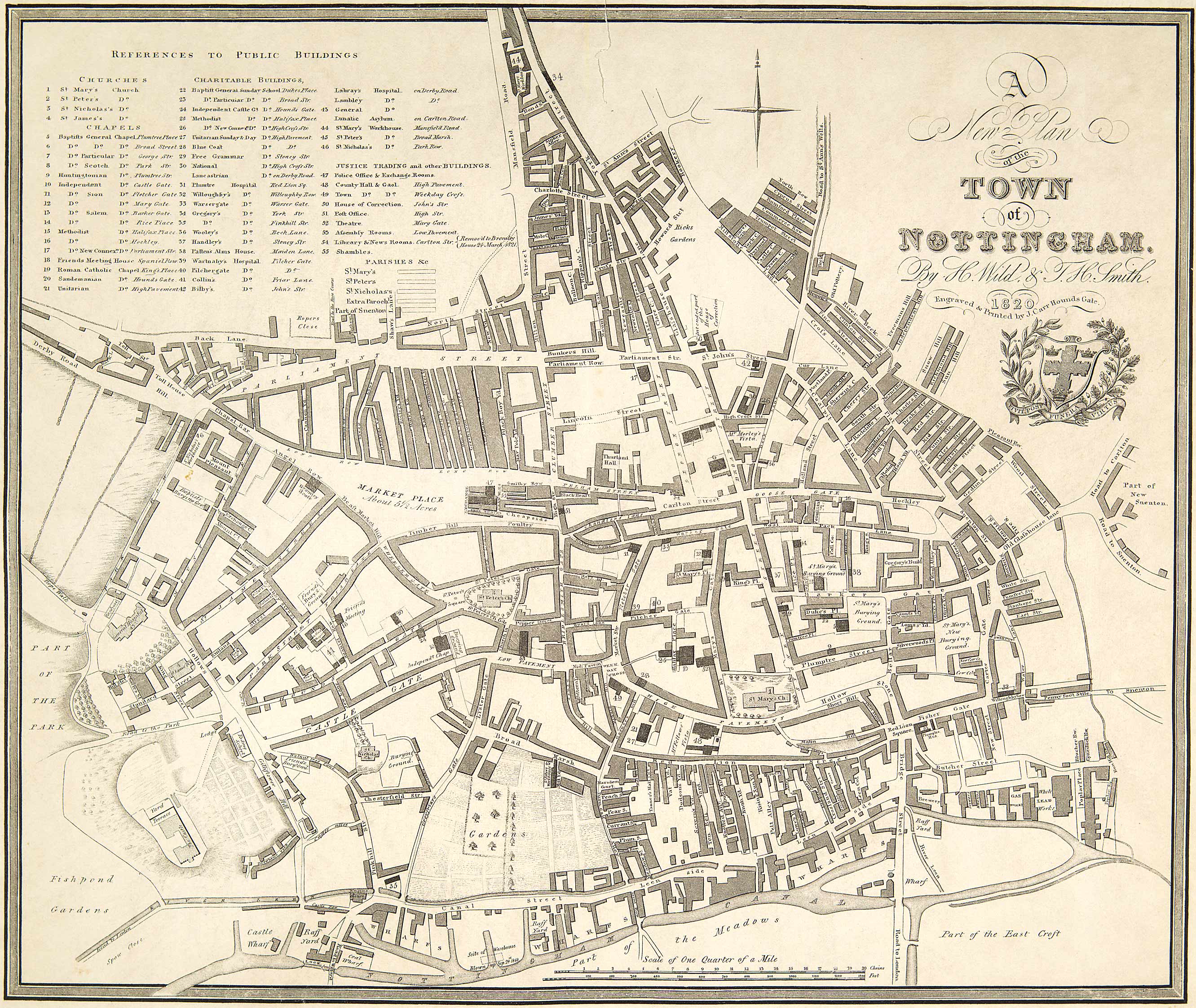
- Jan: Frederick Jackson appointed by Inclosure Commissioners as Surveyor & commissioned to survey the land to be enclosed (NAO: CA 8212/1-4) (after viewing this astonishing map at the NAO I paid for and photographed the concise print of that map, and informed them that I was going to release my photo into public domain; they told me that I could not do that; I am fairly sure that they cannot stop it (advice welcomed), but deleted all my photos & got my money back). A low-res PDF of the same map is available for download at this Nottingham Maps page and also at Notts History. The second (1893) version can be viewed in JPG at NG Spaces.
This was performed in at least two tranches: 1851 + 1861 (pre-enclosure), then revised in 1893 following initial enclosure.
Curiously, Blue Bell Hill Road is already on that map, as are plots for the streets that became Ridgway Street through to Edginton Street; St. Bartholomew’s Church does NOT exist, and neither does Saint Bartholomew’s Road, though there is a Bartholomew Stile Footway (even longer than the modern road, it swings to the north at the top & reaches the edge of Jackson’s map).
- 1847
- This was the worst year of the Great Famine in Ireland. The Potato Famine was blazing throughout Ireland from 1845 to 1849. It is reckoned that a million died and a million fled to other lands; the largest from a single island, ever. The immediate cause was potato blight (a fungal disease) but the whole was exacerbated by political failure of the London Whig government to govern humanely. After Henry Ⅵ, Cromwell & then this experience it should be zero surprise to everyone that a majority of the Irish people decided that they wanted out of the UK deal.
- The term ‘Lace Market’ becomes affixed to that area.
- 1848
- Latest nationwide cholera epidemic (which Nottingham escaped); burns itself out in 1849.
- MR extend their rail-line to Newark & Lincoln and transfer Nottingham services from the old terminus station west of Carrington Street to the site of the current through station, newly opened. The old terminal becomes a Goods Station & gets 2-story offices in 1875, being eventually replaced by a set of legal offices. The only elements of the terminus station that survive are the gate piers (Grade Ⅱ listed) that frame the current entrance on Carrington Street down to the Canal towpath and the Magistrate’s Courts.
- TC Hine designed homes built on Park Valley: [7 (Grade Ⅱ listed)].
- 1849
- Sale of land to meet Enclosure costs (Southey Street).
- New Sanitary Committee starts demolishing insanitary houses (built over privies) & other actions to improve matters.
- 1800s mid:
- Start Date for [The Dower House],(way/257362751) Yew Tree Lane, Clifton]
- Start Date for Home Farm, Holgate, Clifton]
- Start Date for 10 Nethergate Farmhouse, Nethergate, Clifton]
- 1850
- Watson Fothergill-designed homes built on South Road: [3 (Grade Ⅱ listed)].
- TC Hine (and other)-designed homes built at The Ropewalk: [11].
- Start Date for Sneinton Baths; architect: Henry Moses Wood.
- 1851
- Jun: Jackson’s plan is exhibited, and land begins to be released; 120 acres allotted to town Corporation in Trust to create a “green collar” for the town, and this creates continuous avenues of trees.
- Aug: commissioner George Sanderson dies.
- The 4ᵗʰ Duke of Newcastle dies; his son Lord Lincoln succeeds to the title as the 5ᵗʰ Duke.
- The 1ˢᵗ steam-powered factory is built by Hine & Mandella at what is now the site of Loxley House.
- TC Hine-designed homes built on Park Ravine: [1]; note: the Park wiki states that this house is on Clifton Terrace, whilst the City Highways Register disagrees.
- 1852
- Arboretum opened (Grade Ⅱ* listed).
- 1854
- Local architect Thomas Chambers Hine is appointed “Surveyor of the Newcastle Estate”, superseding Robinson.
- 1855
- TC Hine finishes the Park Tunnel. He has also produced a plan for the entire Park Estate, modified from that produced by Robinson to actually fit the topology. The layout shown within the 1862 Salmon map (see MSS maps) is almost identical to Hine’s plan. A storm of building begins within the Estate and many Nottingham architects make their name across the next decades with National Heritage-listed houses.
The Nottingham Council Park Estate Conservation plan identifies 355 large estate houses that were built in the Park before 1918. It declares the Park to be “predominantly residential with approximately 450 houses and 700 flats”, and a resident population of 1,900 (in 2007). Many of those flats were created within the pre-1918 houses (which also is the predominant fashion with landlords throughout the UK). 12 of the original 355 pre-1918 estate houses have been demolished & replaced by small houses or flats.
Holland Walker (whoever s/he is) states “there is some evidence to suggest that from 1855 ‘Siberian Elms were freely planted along newly laid out roads’”. The 1882 OS map, surveyed in 1881, is very detailed and shows regularly spaced trees at approximately 8.5 metre intervals along most of the estate roads (about 1300 then, 550 in 2007). Tree Preservation Orders were made on Park trees in 1966 & 2002. The tree species include sycamore, common lime, London plane, ash, beech, English oak and horse chestnut, with more recent additions including Norway maple, cherry and rowan.
The Nottingham City Highways Register shows that Park streets & pavements are, indeed, unadopted (see this 2016 post for more on that key). None of this is currently within OSM so I’m adding ‘unadopted=yes’, ‘start_date=1855’ + ‘operator=Nottingham_Park_Estate_Ltd.’ to almost all Park streets.
Some Castle Conservation streets are also unadopted, although I am unsure as to the Operator in that case. This creates an oddity, as the very first domestic building in the Park (St Mary’s Vicarage + St Peter’s Rectory, built 1809) is today placed in the Castle district & streets next to that building are adopted by the Council. Standard Hill on the Park side of King Charles Street is unadopted, yet placed entirely within Castle rather than Park. - TC Hine designed homes built at Park Ravine: [Terrace House].
- TC Hine designed homes built at Lenton Road: [1+3 Castle Rising (Grade Ⅱ* listed)].
1+3 Lenton Road are HE Registered, but there appears to be a mistake in the Historic England #1270736 listing. The status is: “Castle Rising (3) and attached area railings; 6 Castle Grove”. The HE GPS location marker for this listing is at the middle of the centroid for 1+3 Lenton Road. The Ordnance Survey map used by HE shows the front-doors for 1+3 facing on to Lenton Road (same as OSM), whilst the door for #6 is at the Castle Grove side of 1 Lenton Road. OSM has #6 on the same wall as 7 Castle Grove’s front door — I have zero knowledge as to which is accurate. 6+7 Castle Grove were also built by Hine the following year, though in a different brick, and share a common wall with 1 Lenton Road. 7 Castle Grove is positioned on the corner of the two roads. - Nottingham Canal ownership passes into the hands of a Railway company (Ambergate, Nottingham, Boston and Eastern Junction Railway Company); all canals had declined in profitability as soon as Rail companies got their knees under the table.
- Nottingham Chamber Committee complains that Inclosure is not yet complete after 10 years & no land can be resold until it is.
- TC Hine finishes the Park Tunnel. He has also produced a plan for the entire Park Estate, modified from that produced by Robinson to actually fit the topology. The layout shown within the 1862 Salmon map (see MSS maps) is almost identical to Hine’s plan. A storm of building begins within the Estate and many Nottingham architects make their name across the next decades with National Heritage-listed houses.
- 1856
- TC Hine-designed homes built at Castle Grove: [Hine House (Grade Ⅱ listed)] [2 (Grade Ⅱ listed)] [3 (Grade Ⅱ listed)] [Barbican House (Grade Ⅱ listed)] [5 (Grade Ⅱ listed)] [7 (Grade Ⅱ listed)]
- TC Hine-designed homes built at Newcastle Drive: [1] [3] [5] [7] [9] [11] [13] [29] [31] [33] (all completed 1859)
- 1858
- Parliament Local Government Act offers town corporations extensive powers of self-government & local improvement.
- TC Hine-designed homes built on Lenton Road: [25] [27 Lenton House] [28] [29] [30] [31 Leslie Villa] [Cliff House];
- TC Hine-designed homes built on South Road: [1 (Grade Ⅱ listed; this house is also Cavendish Crescent South: [13 The Studio]].
- Borough Engineer for Nottingham Marriott Ogle Tarbotton designed & built a 6m tall brick monument to the St. Ann’s Well (the location was due to be flattened at that time).
- 1859
- Feb 28: town council agreed to adopt the 1858 Local Government Act ; Corporation became a Board of Health, taking over responsibilities for streets, buildings, sewers & slaughter houses.
- Oct 6: Marriot Ogle Tarbotton appointed as first full-time Borough Surveyor.
Tarbotton completed a report on the sanitary condition of the town. In the Meadows, houses were built with ground floor rooms below the flood level of the Trent. Many were drained into cesspools, none had drainage with a proper outfall, and most took their water from wells. 752 houses built, of which 500 lacked adequate drainage (period 1859-60: this is a clear flouting of the Inclosure regulations, and suggests that the referee was unable to enforce the rules). Inclosure commissioners were supposed to, but had not, sorted out sewers for these new houses. In addition, many of the houses were not raised above the ordinary level of the ground, and are consequently at the same level as the sewers must be laid, and thus are liable to be flooded and permanently damp. (RBN ix, 148-9).
Tarbotton: There is no correct plan of the town or neighbourhood in the hands of the corporation, no established system of levels, no complete record or plan of subterranean works and sewerage, and there are no public data whatever to aid the consideration of a subject like that of sewerage … most public improvements and operations have been conducted irrelatively.
- 1860
- Letter from town clerk to Inclosure Commissioners: “several of the public roads set out by you are not yet either sewered, paved or macadamized … until your award is made no public body has power to interfere. This state of things is calculated … to produce disease”.
- TC Hine-designed homes built on Park Row: [East Lodge (Grade Ⅱ listed)]
- 1861
- Victoria’s consort Prince Albert dies. Victoria enters into a profound melancholy.
- Tarbotton concludes that the Inclusion Commissioners need support from the town council.
- Dec: Inclusion Referee William Booker died. The town council placed Tarbotton effectively in to Booker’s role of Referee (he could not actually assume that role until he was 30, which would be Dec 1864).
- TC Hine-designed homes built on Cavendish Crescent South: [15] [19 Amelia House] [21 Albert Villa]
- TC Hine-designed homes built on Lenton Road: [13 Fairholme] [15] [17 Oakhyrst] [19] [21 Ravine House] [23 Rutland House]
- Nottingham population grew by 17,000 between 1851 & 1861, yet by only 5,000 between 1841 & 1851.
- 1862
- November 25: Notts County Football Club founded (web wiki). Oldest professional association football club in the world.
- River Leen is culverted & caused to flow into the canal; the old course is filled up solid & abandoned; the Leen is now consciously used to dispose of the town’s sewage.
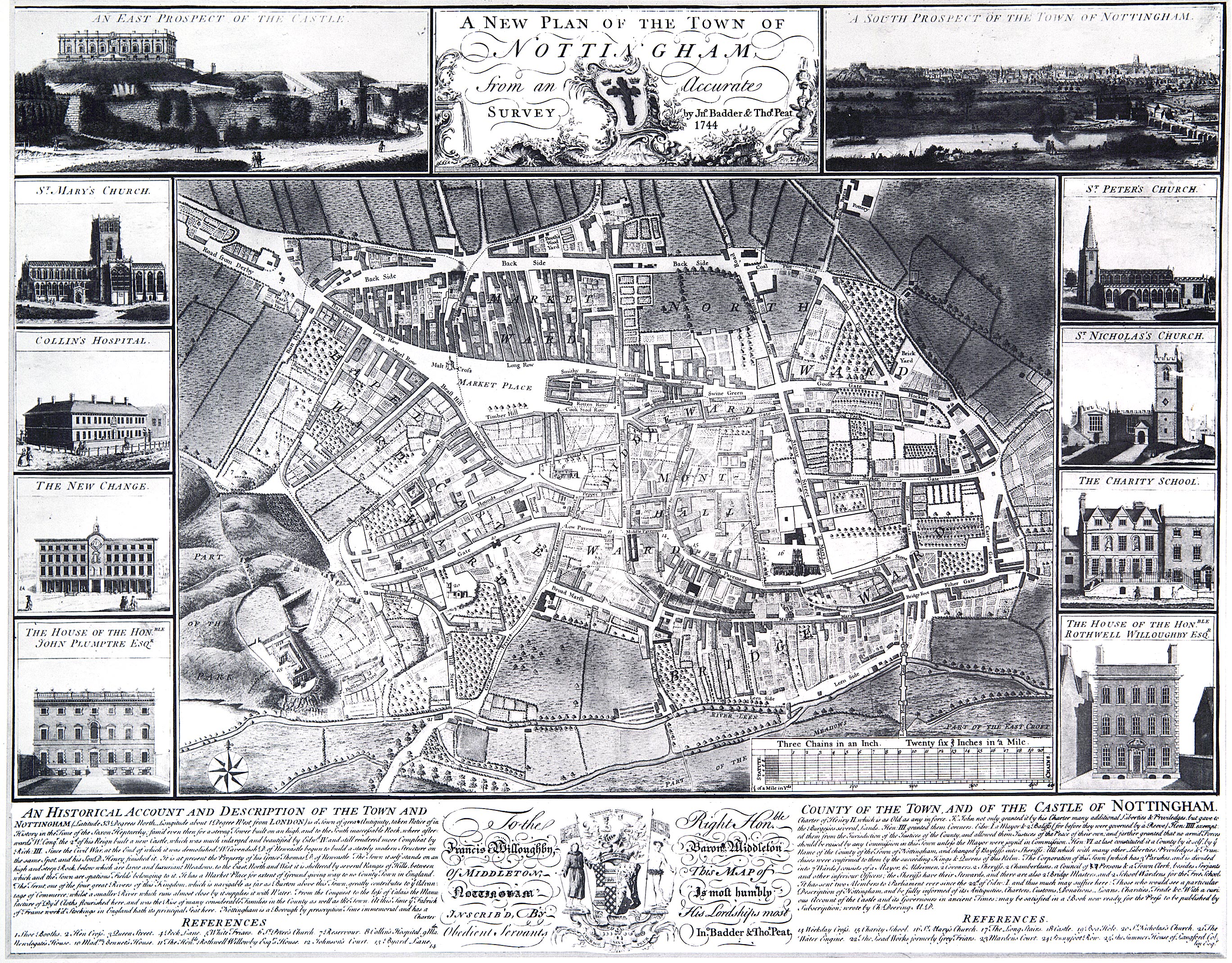
- Edward W. Salmon released his map: “Plan of the Town of Nottingham and its Environs”; see the MSS page with high-quality scans of sections of Nottingham maps produced in 1707, 1744, 1820 and 1862.
Things to note:–- in 1820 the Bek (then known as “River Beck”) which rises at St. Ann’s Well, has not yet been culverted and still flows down St. Ann’s Well Road, turns left into Brook Street, flows south-east and then essentially becomes the eastern boundary of Nottingham as it flows due south from Snenton (sic) into the River Leen and thence into the River Trent.
- in 1862 the stream is fully culverted
- the Bek surprisingly avoids the 1820 Beck Street, although the modern Beck Street does pass along it’s old stream bed.
- no Trains supply the town in 1820, only the Canal
- in 1862 far more trains (at least 3) supply the town than today
- the southern navigation of both the Leen & Tinker’s Leen are dramatically different in 1820 to today
- building in the south of St. Ann’s in 1862 has begun, with Robin Hood Street, Promenade, etc.; the beginnings of the modern town can clearly be seen.
- 1863
- Formation of Victoria Street (NAO CA 3616, 303).
- 1864
- Nov 4: The new (religious, not civil) Parish of St Ann is designated with a consecration ceremony by the Bishop of Lincoln at the newly-built Parish Church (architect: Robert Clarke). It was built at a greenfield site next to the River Beck on the site of what is now St Ann’s Valley Centre (the Bek was culverted shortly after). The council allowed it to celebrate a final Easter in 1971 & tore it down the day after.
- Death of 5ᵗʰ Duke; the Newcastle Estate becomes now managed by Trustees.
- 1865
- Nottingham Forest Football Club founded (wiki).
- Queen’s Hotel built at 2 Arkwright Street (facing the MR station).
- TC Hine (and other)-designed homes built on Holles Crescent: [1] [3] [5 Holles House].
- TC Hine (and other)-designed homes built on Kenilworth Road: [5 The Chestnuts] (completed 1870);
- Homes built on Lenton Avenue: [3 Cedar House], [5] (all completed 1875).
- Charles J Phipps designed the Theatre Royal built at the top of the newly widened & re-named Market Street (Grade Ⅱ listed. Market Street was formerly called “Sheep Lane” & was widened in 1864. See also 1760 for The Old Theatre Royal.
- June 29: Inclosure Award completed. Proclaimed on Sunday 2 July with an official note nailed to the door of St. Mary’s church (holy lutheran doctrine!).
- 1867
- May 24: The powers of the Inclosure commissioners were transferred to the Highways Committee, who then took responsibility for completing the new roads & sewers (NAO OA 7732).
- 1868
- The new (religious, not civil) Parish of St Matthew is designated.
- Marriott Ogle Tarbotton starts construction of cast-iron Trent Bridge (completed 1871) as replacement for the Hethbeth bridge.
- John Loverseed-designed homes built on Pelham Crescent: [3] [5] [7] [9] [11] [13] [19] (completed 1872).
- April 13 (Easter Monday): 1ˢᵗ Public Lending Library opened at 8 Thurland Street on the same site as the former Artizans’ Library (itself opened 1853) (see also wiki).
- 1869
- MR purchased & filled in the Westcroft Canal, then expanded their Station Street rail station with a 3ʳᵈ platform + goods tracks.
- A Parish boundary marker (Grade Ⅱ listed) exists on the southern tow-path alongside Castle Lock.
- 1870
- Clifton Pit is opened (the exploratory pit was sunk in 1870).
- TC Hine (and other)-designed homes built on Lenton Avenue: [1] [7] [9 (completed 1875)] [23].
- Homes built on Cavendish Crescent North: [1 Carisbrooke House / Coach House (completed 1875)] [3 Cavendish Lodge (completed 1875)] [23].
- Homes built on Cavendish Crescent South: [17].
- Homes built on Newcastle Circus: [2 (completed 1875)].
- Homes built on North Road: [6 The Lodge, Yorke House (completed 1880)].
- TC Hine designed homes built on Park Valley: [1 Arundel House / Arundel Lodge] [3].
- John Loverseed-designed homes built on Pelham Crescent: [1] [10] [12] [14] [16] (completed 1875).
- 1871
- Bestwood Colliery begins.
- Linby Colliery begins.
- TC Hine-designed homes built on Kenilworth Road: [2 Yew Tree House].
- John Loverseed-designed homes built on Pelham Crescent: [15] [17].
- Start Date for Village Road, Clifton: [2 The School House (Grade Ⅱ listed) + 1 Clifton Village Hall (Grade Ⅱ listed)] plus the Boundary Wall is also Grade Ⅱ listed.
- 1872
- Nottingham Tramways Company established (1ˢᵗ horse-drawn trams in the town; a private company).
- Watson Fothergill-homes built on Lenton Road: [7 Fothergill House (Grade Ⅱ listed)].
- TC Hine-designed homes built on North Road: [7 Claremont].
- Hiram Codd of Camberwell, London invented the Codd Bottle, a method of sealing pop (carbonated water drinks beloved by youngsters) bottles, using a glass marble in the neck.
- 1873
- Newstead Colliery begins.
- Marriott Ogle Tarbotton lays the foundation stone for the Gunthorpe Toll Bridge (completed 1875, replaced 1927).
- Hicking Lace Factory constructed (updated 2005 as residential flats);
- Watson Fothergill (and other)-homes built on Lenton Road: [5/5a/5b Castle Bank (Grade Ⅱ listed)].
- Homes built on Tattershall Drive: [3].
- 1875
- TC Hine (and other)-designed homes built on Cavendish Crescent North: [9 Peveril Towers (Grade Ⅱ listed)].
- TC Hine (and other)-designed homes built on Cavendish Crescent South: [3 Kirkstall Lodge] [5] [7] [9;9a] [11].
- TC Hine-designed homes built on Clumber Road West: [Linden House].
- TC Hine-designed homes built on Duke William Mount: [1].
- TC Hine (and other)-designed homes built on Lenton Avenue: [11 Fernleigh] [25 Arlington House] [31 Graylands] [33 Newlands].
- Robert Evans JP-designed homes built on South Road: [2 (this house is also Cavendish Crescent South: [11]].
- Homes built on Tattershall Drive: [1] [2].
- 1876
- Parliament votes to grant Queen Victoria the additional title of “Empress of India”.
- TC Hine converts the fire-damaged Castle into a Museum of Fine Art (completed 1878) (1 Bridge Street; Grade Ⅰ listed).
- Watson Fothergill (and other)-homes built on Cavendish Crescent South: [23 Holyrood House] [25 Sutherland House].
- Edwin Loverseed-homes built on Lincoln Circus: [Gladstone House (completed 1877)].
- 1877
- Town council brought the suburbs within the town boundary (main districts were Basford, Bulwell, Radford, Lenton, Sneinton, and Wilford north of the Trent) (RBN ix 222).
- TC Hine (and other)-designed homes built on Cavendish Crescent South: [1 Gladstone Court].
- Samuel Dutton Walker-designed homes built on Cavendish Road East: [43 Ashley Mews] [45] + Park Drive [Ashley House] (these three houses were originally a single property).
- TC Hine (and other)-homes built on Newcastle Circus: [7 Mevell House (Grade Ⅱ listed)] [Burton House] [Castlethorpe].
- Start Date for the Nottingham and District Tramways Company Limited, who operated a horse and steam tram service (bought out by the council in 1897).
- 1878
- Corporation leased 638 acres at Stoke Bardolph from Earl Manvers. MO Tarbotton directed construction of a sewage farm (see also MSS).
- Homes built on Lenton Avenue: [19] [21] (both completed 1880).
- Albert Nelson Bromley-designed homes built on Newcastle Drive: [15] [17].
- TC Hine-designed homes built on Park Valley: [25 (Grade Ⅱ listed)].
- Start Date for 82 Village Road, Clifton.
- 1879
- TC Hine-designed homes built on Clumber Road East: [Penrhyn House (note: house has no-number)].
- Start Date for The Forge: Glapton Lane, Clifton.
- 1880
- Nottingham Corporation (local council) purchased the Nottingham Waterworks Company. The former borough surveyor Marriott Ogle Tarbotton was transferred to the company as principal Engineer (his deputy Arthur Brown took over the position). The company had considerable involvement in Gas, Water and Sewage within Nottingham.
- Homes built on Park Ravine: [4 Iveston House]; note: the Park wiki states that this house is on Clifton Terrace, whilst the City Highways Register disagrees.
- TC Hine (and other)-designed homes built on Lenton Avenue: [13] [15].
- Homes built on Cavendish Crescent North: [7 Jardine House (completed 1882)] [10 (completed 1890)] [11 Gleadthorpe (completed 1895)].
- Following council purchase of land from the Trustees of the Gregory Estate, borough engineer Marriott Ogle Tarbotton builds Gregory Boulevard. This is a 60 feet wide road linking Mansfield Road to Alfreton Road.
- June 28: Radford Baths opened. The baths closed in the 1980s & have subsequently been demolished.
- 1881
- June 30: University College is founded (see also 1948).
- TC Hine builds 18, 19, 20 Park Terrace (this was originally a single house, but has been split into three; it is notable for not just having a Historic England listing, but also for boasting a retaining wall high above the Park Tunnel).
- TC Hine-designed homes built on Cavendish Road East: [37 Cavendish House].
- Homes built on Clumber Crescent South: [5 Park Hall].
- RC Sutton updates a shop at Goose Gate: [Hockley Lanes 16-22] (Grade Ⅱ listed). This is one of the more famous shops in Nottingham, as it was the first opened by Jesse Boot. The house itself is dated at mid-1800s.
- 1882
- Homes built on Cavendish Crescent North: [5] [19]
- TC Hine-designed homes built on Lenton Avenue: [27] [29] (both completed 1883).
- 1883
- Watson Fothergill-designed Inn built on Castle Road: [1, 3, 5, 5A, 7 and 7A Mortimer House (Grade Ⅱ listed)].
- Borough Engineer Arthur Brown plans & builds Beck Valley Storm Water Culvert that runs from the Trent at Trent Lane (diameter: 13′ 6″ x 9′ 8″ | 4.11m x 2.95m) to St. Ann’s Well Road at junction with Cathcart Street (diameter: 6′ 9″) (Cathcart Street was torn down in the 1970s); completed July 1885. [R/HR/3/1/25].
- TC Hine-designed homes built on Cavendish Road East: [27 Bishop’s House] [39 Overdale] [41 Elmhurst].
- TC Hine-designed homes built on Clumber Road East: [Edale House (note: house has no-number)].1902
- 1884
- Lenton Boulevard (now Castle Boulevard) laid out. Between 1880 & 1884 Tarbotton & then Arthur Brown laid out Gregory, Radford, Lenton & Castle as 60′ wide boulevards to speed those from the new city suburbs to be able to quickly access the town centre.
- TC Hine (and others)-designed homes built on Cavendish Road East: [25] [29 Gartree House] [31 Castledene].
- Albert Nelson Bromley-designed homes built on Newcastle Drive: [21] [23] [27 Glendower (completed 1885)].
- A Covered Reservoir (to store water) + Police House built on Woodborough Road opposite the top of Porchester Road (NA ref: CA/W/4/2).1902
- 1885
- Raleigh Bicycle Company workshop setup in Raleigh Street, Nottingham. Shortly after transferred to Russell Street (Number 65 is just one building that they used on that street; Grade Ⅱ listed).
- Homes built on Cavendish Crescent North: [12] [15] [16] [17] [18] [20] [22] [24]
- Arthur George Marshall-designed homes built on Clumber Road East: [Adam House].
- TC Hine-designed homes built on Lenton Avenue: [17 Dundee House].
- 1886
- Watson Fothergill (and other) homes built on Newcastle Drive: [19] [39 (Grade Ⅱ listed)].
- Site designated for St Bartholomew’s Church; an iron church is translocated there same year (see 1900 for permanent church). It sits (just) within the Parish of St Mary, with the Parish of St Matthew to the south, and the Parish of St Ann to the north. The location lay between the two modern Wickens Walk service roads; it was torn down in 1971.
- 1887
- TC Hine-designed homes built on Duke William Mount: [2] [3].
- The Tarbotton monument on the site of the St. Ann’s Well (see 1856) was torn down to allow a bridge for the Nottingham Suburban Railway to be built across the Wells Road.
- 1888
- Local Government Act was an extension of the 1835 reform act; the latter was designed to reform corruption within Municipal Corporations (towns), whilst this Act was designed to extend the same reforms towards Counties. The scope of the Act was also extended towards 10 named cities (which included Nottingham) which would be “dealt with as separate counties”, and were henceforth called “County Boroughs”. Amongst the many powers and responsibilities transferred to the councils (as one example) was to be able to build Police Stations.
- Homes built on Fishpond Drive: [4] [6] (completed 1890).
- Homes built on Kenilworth Road: [1 Iveston] [3 Kenilworth House].
- 1889
- Watson Fothergill-designed homes built on Huntingdon Drive: [3 (Grade Ⅱ listed)] [4 (Grade Ⅱ listed)].
- Homes built on Peveril Drive: [Dudley Lodge]
- December: Nottingham Suburban Railway opened.
- 1890
- Homes built on Cavendish Crescent North: [11 Gleadthorpe] (completed 1895).
- TC Hine-designed homes built on Cavendish Road East: [23 Kingston House].
- Homes built on Clare Valley: [1] [2] [3] [4] [5].
- Homes built on Tattershall Drive: [4 St Ives].
- Homes built on Western Terrace: [2].
- 1891
- TC Hine retires. Only a few vacant plots remain within his 1855 plan for The Park. By 1918 that plan is complete with 355 houses.
- 1894
- September 18: 1ˢᵗ Electricity Power Station constructed (only a Substation remains) (wiki).
- Castle Court, Castle Boulevard (Grade Ⅱ listed) started.
- 1895
- Fellows, Morton and Clayton pub + warehouse built (date on front of building). The pub, which is at 54 Canal Street, is Grade Ⅱ listed as a pub (which it also is today), whilst the warehouse, which is at 52 Canal Street, is Grade Ⅱ listed as a canal museum (which it is not, today it is a pub). Then we have the two late 19ᵗʰ Century Wharf Cranes [1] [2] which are each Grade Ⅱ listed and sit canal-side of the warehouse. Finally, the two metal gateposts [1] [2] and metal railings at the entrance between the two pubs are also collectively Grade Ⅱ listed.
- Watson Fothergill-designed homes built on Castle Boulevard: [62 + 64 Grade Ⅱ listed].
- Homes built on Tattershall Drive: [5].
- Homes built on Western Terrace: [1 Broadgate].
- 1896
- Homes built on Cavendish Crescent North: [14 Park House (Grade Ⅱ listed + Boundary Wall listed)]
- June 15: Start Date for Victoria Baths; former Sneinton Baths on same site — see 1850 — were torn down & rebuilt by Arthur Brown.
- 1897
- June 18: City Status awarded to the town under a Royal Charter by Queen Victoria on the occasion of her Diamond Jubilee.
- Stockdale Harrison-designed homes built on Cavendish Road East: [33 Redcliffe].
- The Great Central Railway (GCR) constructed a girder truss bridge to carry it’s trains over the MR station & to connect with it’s Victoria Station (completed 1900). That bridge was in the identical position as the modern Karlsruhe Friendship Bridge that carries trams over and inter-connects with the rail station. The tunnel that took GCR trains to Victoria went under the centre of town, still exists, and emerges direct at the southern-wall of the basement of the existing Victoria Centre that replaced the former railway station (you need someone with a key to get ingress). The old concourse + tunnel entrance at the northern end also still exists 4 stories outside in the grassy area below the Victoria Parking Centre (you need to be tall to see over any of the walls, and careful not to fall), although there is now zero access to that tunnel.
- June 14: Corporation purchases Nottingham and District Tramways Company Limited for £80,000 (equivalent to £9,660,000 in 2021); this is horse-drawn trams, although some experiments were made with steam-trams in 1880. The name of the corporation company is Nottingham Corporation Tramways.
- 1899
- Nottingham Suburban Railway + bridge over Wells Road completed.
- Nottingham Corporation Act, which gave powers for the corporation to run an electric tram service (see also 1897).
- 1800s (late)
- [1] [2] Wharf Cranes (Grade Ⅱ listed) (stored outside the Fellows, Morton and Clayton warehouse).
- Details:– 1900 to current
Discussion
Comment from craghead on 5 November 2022 at 16:22
Hi. This is a very impressive historical compilation. It makes most interesting reading. Did message the author directly but will put my comments up here as well. Keep up the excellent work.
With reference to the 1861 entry details where it is stated “Nottingham population grew by 17,000 between 1851 & 1861, yet by only 5,000 between 1841 & 1851”, I could make a slightly educated guess that due to the effects of the Potato Famine in Ireland around 1847, where a large portion of the population emigrated all over the globe, a large number would have headed to Britain looking for work, where they may have already had family connections, in places such as Nottingham?
Comment from alexkemp on 6 November 2022 at 02:35
Hi craghead, thanks for your comments.
I certainly agree that the Potato Famine is a major event in the UK that needs to be recorded in this listing. I also concur to the large presence of Irish in Nottingham (in St Anns where I live, it is mostly southern Irish).
The beginning of the Railways was in 1825 (the SDR), and together with the massive increase in building + services (electric, water + sewage) there would have been vast demand for Navigators which, of course, the Irish became famous as exemplifying.
I’ve already begun to add the Famine to this listing. However, I’m doing it in my way, which is a comprehensive manner, so I’ve started with “Early to 1199” and am recording the beginning of the Roman Catholic religion, the difficult interaction with Celtic Christianity, then the nightmare of Irish & English relations. That will keep me going for a while. In the meantime, I’ve already spent a month on collecting all the Caves in Nottingham, and am also checking & finalising them (currently, 521 sets of caves).
Thanks again, - AK