
You Don’t Have to be Mad to Live Here, But it Helps
Posted by alexkemp on 25 May 2019 in English. Last updated on 22 June 2022.
Above is a small panaroma of some of the buildings that currently front part of Carlton Road close to Nottingham town centre. Behind the camera is the ancient ecclesiastical parish of Sneinton whilst in front of the camera is the (relatively recent) ecclesiastical parish of St Luke, which is within the Civil Parish of St. Ann’s (which, for the sake of accuracy no longer exists, since it is subsumed into the Unitary Authority City of Nottingham, but does still exist as the political St. Ann’s Ward).
I live in St. Ann’s (although my neighbours call it Thorneywood) and was amazed moving here at the number of:
- Religious places (churches, mosques, temples)
- Public Houses (‘pubs’ — drinking establishments)
- Psychiatric Institutions
The little panorama above has at least one of each: the Duke of Devonshire pub on the right (commonly known locally as “THE MADHOUSE”) and The Congregation of Yahweh at far left (mostly hidden). The Moot (on the left, https://wiki.openstreetmap.org/wiki/Tag:start_date=1812) is the oldest building on that street. It was originally a Church Hall and (later) a drinking establishment.
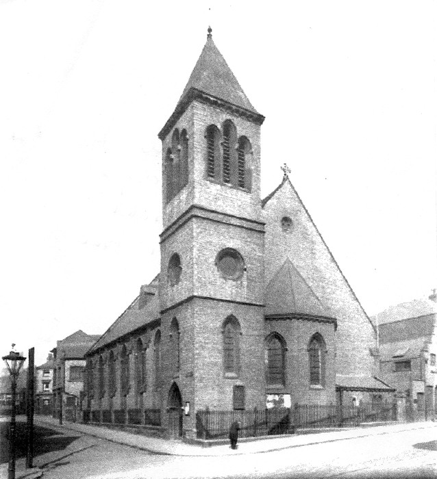
Both pubs are currently closed down and Yahweh is built upon the site of the former Parish Church (below, and you may be able to spot The Moot on the right, which was closed in 2017 and has been bought by the Congregation, who plan to turn it back into a Church Hall):
Information from locals on the Duke of Devonshire is that plans have been lodged with the Council to turn it into an apartment block. This is the sign fastened to the outside of the building explaining why it was locally known as “The Madhouse”:–

In fact, Lunatic Asylums are a feature local to St. Ann’s and not just to it’s Creative Centre (of which these buildings are a part), and my belief is that that fact may be related directly to it’s creation date.
The Inclosure Acts or, Legalised Theft
The 1st Enclosure Act local to Nottingham was 1845 and, at that date, the land immediately outside the city gates was all common-land & open pasture, two large open-fields known as Clay Field & Stony Field. Nottingham got into the act of Inclosure (otherwise known as stealing the common land from the people) very late; the practice began in 1604 but Nottingham people resisted it for hundreds of years. Indeed, the final village in Europe to retain the practice of Open-Field/Strip-Field farming is in Nottinghamshire, in the small village of Laxton.
In villages such as Laxton the land in & around the village was held in common by all families in the village. All the land was divided broadly into 4 fields, and each field individually into strips. Each year, all heads of each family would meet together within the village hall to decide which strips of land each family would farm during the next year. One field would be left fallow for 1 year in 4, so only 3 fields would be divvied up each year. All farmers knew each field, and each section in each field, intimately. The idea was to share it all out so that each family got an even chance for a good harvest.
That is the reason that ancient farmhouses are always found within the village. It is only following Inclosure that farmhouses were built upon the farmland itself. I will also give a wave to Mr Rose of Laxton (Chairman of the Laxton farming committee), whom I knew from when I worked for the National Farming Union in the 1970s & 80s, and who passed on the info written above.
Lunatic Asylums
If you read the Diary on 1869 Bancroft Building you will see that the very first housing in St. Ann’s was built ~1860. The Church History of St. Luke points out that streets & roads had been laid out upon Clay Field by 1861. The foundation stone for St, Luke was laid on 2nd July 1861, and the church was completed and opened in 1863.
You can see from the Notice Board above that the General Lunatic Asylum was built at the bottom of Dakeyne Street in 1812, and that therefore there was a pub on Carlton Road at that time, which is 50 odd years before the street-plan was fully determined (Carlton Road was the main route to Carlton). However, a Lunatic Asylum is fine when positioned in the middle of an empty field with just crows for company, but not so desirable as a main attraction when surrounded by the suburban middle class.
The Nottingham Borough Lunatic Asylum opened in Mapperley Top in 1880, surrounded by 125 acres of farmland to feed & pay for upkeep, and only brick-kilns for distant company (I provided Network support there at the beginning of this millenium). The inmates of the Dakeyne Street General Lunatic Asylum were shipped off to Mapperley when it opened & their own building was torn down. There was yet another asylum built at the top of Thorneywood Mount where it met Porchester Road (a psychiatric Hospital remains, the asylum does not).
One Source of the Madness
In the Old Town of Nottingham the population obtained it’s water by digging wells down into the sandstone. That was fine & would have been zero problem if they had only not disposed of their sewage in a similar manner. Just a yard or two from the water well. The entire country suffered 6 waves of Typhus & Cholera during Victorian times — both water-born diseases, although the Victorians did not know that — and the nearby St. Mary’s Rest Garden (originally known as St. Ann’s Cemetery) was consecrated in 1835 immediately outside of the town walls as a response to the 1832 Cholera outbreak, which had completely filled all the other cemeteries (that epidemic was part of the 2nd Cholera Pandemic).
You will now understand why so many of the Nottingham population were desperate to leave the typhus-ridden streets of the city & get out into the clean new houses of Clay Fields. And it would have been wonderful. If only the engineers had not used Lead for the pipes that transported clean water into those new houses (traces of heavy metals such as lead are now well-known to interfere with brain function, which is why all old Victorian-era lead pipes have been systematically replaced in the UK with iron, copper, MDPE or other such pipes). The modern folks of Flint & other USA cities will recognise the problem.
Update 21 June 2022
Mapillary has changed it’s download URLs & therefore all links within my diaries that use photos stored in Mapillary are broken. I’m slowly going through to update them. The new URLs are terrifyingly long, but show OK on my screen (and I also hope on yours).
Discussion
Comment from Alan Bragg on 26 May 2019 at 11:36
Excellent
Comment from GOwin on 26 May 2019 at 12:21
Thank you for sharing diary entries like this, Alex. They’re always a joy to read.
Comment from mboeringa on 28 May 2019 at 19:32
Agree, nice reads, one good reason to not close down the diaries entirely as some have suggested in an overly bold response to the spam flow ;-) Thanks.