akadouri's Comments
| Changeset | When | Comment |
|---|---|---|
| 142276477 | about 2 years ago | Giovanni's is moving due to a kitchen fire at this location. While the website says "across the street" I have not seen where that new location will be.
|
| 144851296 | about 2 years ago | "loc_name"="Sauron Tower" 🤔 |
| 133673413 | about 2 years ago | Hello, you added this pole as an "amenity=shower" node/10735242598#map=19/40.70644/-73.94790 Is this actually a shower with hot water or is it more of a misting pole (amenity=mist_spraying_cooler)? It is visible in the mapillary imagery here https://www.mapillary.com/app/?lat=40.7063924&lng=-73.9478912&z=17&pKey=133510786510100&focus=photo&x=0.10227209762070083&y=0.5721130596596734&zoom=0.6063295158359651 |
| 138588404 | about 2 years ago | I think you may have mislabeled the building type on way/276259881 it looks like it's a recreation center part of the state park https://parks.ny.gov/parks/robertoclemente/details.aspx |
| 139459333 | over 2 years ago | The signs (second location node/7006950444) in front both say "Co" but I guess that may be just to save space and the logo design. I could move "Co" to alt_name for search to pick it up. WBurg: https://www.mapillary.com/app/?lat=40.713923&lng=-73.959976&z=17&pKey=242316814358954&focus=photo |
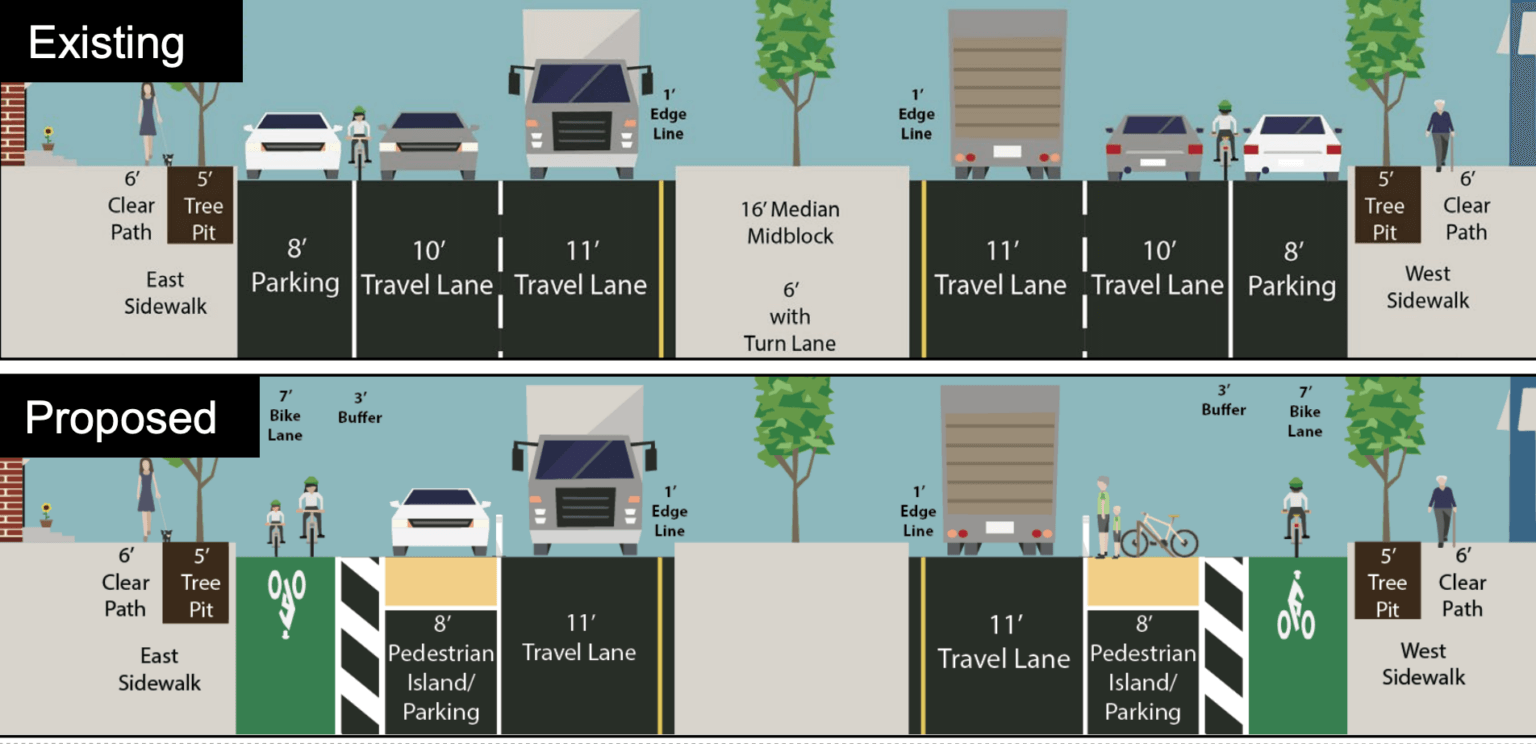
| 137428977 | over 2 years ago | They have a big sign that they support the counter-campaign for the street redesign. There's a lot of drama in the neighborhood around it. Weird because a bar with an outdoor patio would probably get more business if it was nicer to bike/walk to... Possible design: https://www.brooklynpaper.com/wp-content/uploads/2023/05/Screen-Shot-2023-05-11-at-3.32.45-PM-1536x744.png Background:
|
| 130040223 | over 2 years ago | I am wrong about the curbs and dual carriageways, it could have been mapped like node/9197760562. Yeah, splitting carriageways can be messy especially when there are many "hidden" turn restrictions in NYC. |
| 130040223 | over 2 years ago | The only way to capture the type of curbs on each side of the island is to split the road carriageway around it. The carriageways could continue split though instead of merging back together before the intersections. |
| 130524689 | almost 3 years ago | Need to double check bench count note/3492310 |
| 129580686 | about 3 years ago | Why does this section not meet the criteria for highway=busway? It is a designated bus route protected from other lanes of traffic. It may be a short segment, but that doesn't change what it is. |
| 129623319 | about 3 years ago | Hey, I believe these are not uncontrolled crosswalks due to the presence of traffic signals, they could be tagged as crossing=traffic_signal Hopefully iD will be updated soon to reflect this as "Marked Crossing" now defaults to adding "crossing=uncontrolled" https://github.com/openstreetmap/id-tagging-schema/issues/658#issuecomment-1333944173 |
| 129567080 | about 3 years ago | iD updated a couple days ago to set "crossing=uncontrolled" when "Marked Crosswalk" preset is selected. I opened an issue to change that to "cross:markings=yes" instead. https://github.com/openstreetmap/id-tagging-schema/issues/658 Also I didn't realize this was your 3000th changeset! Congratulations! |
| 129567080 | about 3 years ago | Hello, I noticed you recently updated this crosswalk to include `crossing=uncontrolled;marked`
Marking information has been moved to a newly adopted `crossing:markings`=* tag in order to separate control information and marking information. |
| 128976109 | about 3 years ago | Hello, These retail areas are quite inconsistent, for example the area around: changeset/128995293#map=18/40.58706/-73.96013 NYC has highly mixed land use, it may be better to derive your dataset using something like POI presence vs "empty" (no-poi) apartment/house buildings. Or using NYC's government provided zoning/land use https://zola.planning.nyc.gov/about/ Otherwise we're looking at hundreds/thousands of polygons covering individual blocks, which after mapped may or may not be maintained. This is different than say a suburban context where you may have a shopping mall area that is clearly defined. To add onto what jmapb's point, the local community usually discusses large changes on the talk-newyork mailing list. That being said many of us are in #local-nyc in the OSM-US Slack if it is more convenient to have initial discussions there. |
| 129216794 | about 3 years ago | Yeah I go back and forth on it, technically this calms traffic and is also used by pedestrians. landuse=traffic has been abandoned. crossing:island=yes seems to be for nodes. area:highway=traffic_island is another option. I'm not sure it really matters to tag an island as whether or not pedestrians are allowed on it, that should be indicated by a footway going over it. quick stats (NYS):
osm.wiki/Proposed_features/Street_area#traffic_island Anyway, happy to change this to `area:highway=traffic_island` if you think that makes more sense. |
| 129110095 | about 3 years ago | Hello, Thanks for mapping all these sidewalks! Please consider adding "barrier=curb" to curb nodes at the end of crosswalks, it helps when someone is nearby with StreetComplete and can fill in the type of curb later. |
| 128491283 | about 3 years ago | Hello, I noticed you've tagged these ways as foot=no, another option could be foot=use_sidepath. I am not local anymore and am not sure the current status of these roads. |
| 128246602 | about 3 years ago | Hello, I think you included a stray test feature in this changeset - node/10140027295 |
| 126484324 | about 3 years ago | I think this building may have more than one name, both https://magnolia-dumbo.com/ and https://frontandyork.com/ refer to it. |
| 124906308 | over 3 years ago | Hello, this race track is only built for the race weekend and dismantled afterwards. I'm not sure it belongs in OpenStreetMap as it's not guaranteed to be there next year. |