Wookey's Comments
| Changeset | When | Comment |
|---|---|---|
| 174417785 | about 1 month ago | Well spotted. The gate has been moved sometime in the last few years. And yes Vespucci's snapping put the new one in the wrong place. I have now fixed up the two relations using these segments as well |
| 165909049 | 7 months ago | Thanks for spotting that. Yes, Vespucci is prone to auto-including tags from a totally separate earlier edit.
|
| 163380776 | 9 months ago | The spur to the field gate is not part of any of the routes/relations. The mapping was previously wrong, showing the routes (Ridgeway, Icknield Way etc) going along a track that way, with a parallel footway that was not part of any of these relations. In fact the track through the field no longer exists (if it ever did) - it's just a spur to a field gate, and the 'unimportant parallel footway' is in the fact the main route for Ridgeway, Icknield Way etc. So there is no mistake in the mapping now. It looked to me like the relations were still OK, but I could have been wrong. The spur to the gate should be removed from the relations,. |
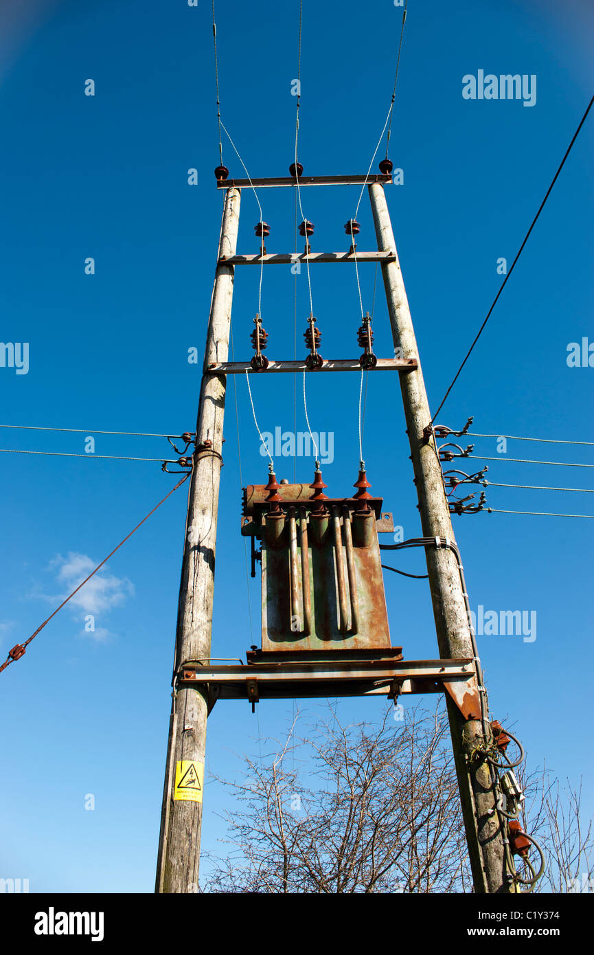
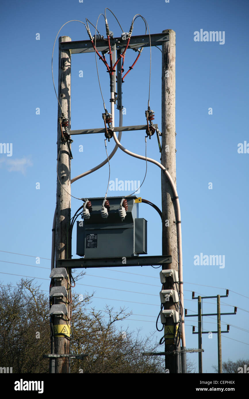
| 139941304 | about 1 year ago | Hmm. Actually that's not a great example as the main line does not go underground there, and the wires do go above the crossbar on pins on that one. So I guess you would call that an H-frame even though the top cross-bar is not really wider than the poles.
|
| 139941304 | about 1 year ago | Hmm. You are certainly correct according to osm.wiki/Tag%3Apower%3Dportal
I'm pretty sure I got that from vespucci and the OSM wiki but I see what you are saying about 'h-frame'. I have certainly tagged some h-frames as portals too, as I was simply unaware of term h-frame. Clearly I need to go back and fix those.
|
| 157549875 | about 1 year ago | Actually vespucci only gives ESRI imagery which is much worse than bing. It's clear in bing that it's the clump that is 30m across. The individual tree is about 16. Fixed now. |
| 157549875 | about 1 year ago | Ah yes. I was on a phone and couldn't remember the right tag (and vespucci only offers the trunk circumference by default. This one really does look about 30m across in the bing images, but I agree that seems implausibly large even for a large mature tree. I'll fix it. I meant to check it when I got back to a real computer, but forgot. Thanks for checking. |
| 154710875 | over 1 year ago | Thanks for spotting that. Paths connected up, and the one in Bruge which is now a duplicate of Wevershof removed. I think those are side-effects of poor net connectivity at the time of mapping. |
| 154711311 | over 1 year ago | They are there because of the unhelpful habit of vespucci (android mapping app) of copying tags from previous edits into new edits. Those two tags came from a location I had edited previously (changeset/154573498)
So thanks for spotting that.
|
| 150312223 | over 1 year ago | No, that was accidental. Cheers for spotting it. Fixed. I blame Vespucci's drag interface which I don't find easy to get to do what you want. |
| 147073942 | almost 2 years ago | Vespucci loves to snap things unhelpfully. The charging space is visible in the satellite pics so I've moved it to the correct side of the road and improved the tagging of all the stations I added. It looks like there are a lot of chargers in back-streets that are not yet on the map. |
| 142784000 | about 2 years ago | I did actually read that list and couldn't find the UK one so put 'UK' as best effort. But I see it is in there really as bs1363 (but the image of a double domestic-type makes it easy to miss when I was looking for something more like https://electricaldiscountedsupplies.com/wp-content/uploads/2020/08/ADWP1SKT-Website-600x626.jpg)
|
| 128906593 | over 2 years ago | I've been told this test takes more like 3 hours than 1.5, so I'll be there later. maybe 3:30-4? |
| 128906593 | over 2 years ago | OK. I'll try and find you there when I come by.
|
| 128906593 | over 2 years ago | AH yes. In-person hadn't occurred to me (I hadn't realised you were in Cambridge too). The weather is nice so that sounds like a good plan. I've actually got to be in Histon for an annual medical check-up at 12:30. I think that will take 1.5 hours or so but it's also a bit uncertain so actually I should be coming back through town around 2pm-2:30pm. Would coming to find you in Peterhouse be a good plan then? Lunch would be nice but it might be a bit late for that in which case we can presumably find somewhere to chat anyway? |
| 128906593 | over 2 years ago | es I am based in Cambridge. A chat would be good.
I'm busy for the rest of today but anytime
I also just (yesterday!) joined #osm-infrastructure matrix channel
|
| 128906593 | over 2 years ago | Your edit to add 'gas topology' in southern Cambridge has resulted in most/much/all of the gas network being in the map twice. Once as the actual pipelines and once as a more approximate 'gas topology' network, often with the pipelines routed in places they do not exist.
|
| 139830877 | over 2 years ago | OK. It's done now. This has taken me all day to sort out so I'm not going to do any more in the area for now! |
| 139830877 | over 2 years ago | Hi Tristan. Looks like we both did a pile of building editing in Surlingham at the weekend which has rather unfortunately overlapped. I've been correcting alignment and building shapes, whilst you've been adding housenumbers and also correcting shapes.
|
| 133975213 | over 2 years ago | Hi. I saw your note about a segment of the old road being deleted by you didn't know how to move NCN51 (and Bernwood Forest Loop) over to the new bridge. I've fixed that today. (along with footpath and power lines north of Claydon Park). |