SomeoneElse's Comments
| Changeset | When | Comment |
|---|---|---|
| 116962327 | almost 4 years ago | You will need to contact Facebook about that. Their "places" data does not come from OpenStreetMap. |
| 116981681 | almost 4 years ago | Hello Andy Parton and welcome to OpenStreetMap,
|
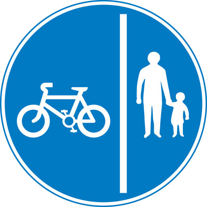
| 116891119 | almost 4 years ago | I don't know what the norm for cycling signage is in Warrington (haven't been there since the 80s) but if it's a cycleway I'd expect something like a blue "cycling" sign - maybe https://assets.publishing.service.gov.uk/media/55ba1284e5274a1521000023/sign-giving-order-route-pedal-cycles-only.jpg or https://assets.publishing.service.gov.uk/media/55ba12b1ed915d155c00001d/sign-giving-order-segregated-cycle-pedestrian-route.jpg , or some tactile paving that says ""cycleway" such as https://www.marshalls.co.uk/commercial/product/tactile-cycleway-unit, or something from the council that says (even if they haven't put up any signage) that they consider it a cycleway. Without any of those it's just a footpath.
|
| 116891119 | almost 4 years ago | Hello,
|
| 116000762 | almost 4 years ago | (on cycling across pedestrian crossings) the Highway Code's very clear that you shouldn't: https://www.gov.uk/guidance/the-highway-code/rules-for-cyclists-59-to-82 . That also means that it's not normally necessary to explicitly tag bicycle=no on every pedestrian or equestrian crossing (not that you likely have many of the latter in Warrington)
|
| 116333609 | almost 4 years ago | Witaj maraf24,
|
| 116333609 | almost 4 years ago | Hello maraf24,
|
| 116962327 | almost 4 years ago | @Hotel Gaj Kesri - when you say "it is showing" - in what map or app is it showing in the wrong place? |
| 116760851 | almost 4 years ago | Thanks - fixed. |
| 114063595 | almost 4 years ago | For info see osm.org/user_blocks/5638 |
| 116448024 | almost 4 years ago | For info see osm.org/user_blocks/5638 |
| 116560398 | almost 4 years ago | For info see osm.org/user_blocks/5638 |
| 116884701 | almost 4 years ago | Specifically this deals with these revert fails from the complex_revert:
|
| 116679532 | almost 4 years ago | Hello - a quick question about way/466428839 , which is highway=no presumably because there's nothing on the ground here. Should it really be part of the Norfolk Coast Path and the England Coast Path, and (a bit of a philosophical question) should it join way/466428842 which it crosses?
|
| 73312487 | almost 4 years ago | Drop an email to [email protected] (with a bit of info about what needs changing back to what) if you'd need us to help figure something out.
|
| 81453505 | almost 4 years ago | Hello,
|
| 116635310 | almost 4 years ago | Thanks |
| 116296386 | almost 4 years ago | Hello MicronationMarker,
|
| 102177655 | almost 4 years ago | Hello Ed,
|
| 116722663 | almost 4 years ago | OSM's Data Working Group had a report that a number of bridleways in the New Forest had "bicycle=permissive" set on them in error. What seems to have happened is that someone assumed that they are actually public bridleways ("designation=public_bridleway" in OSM, where a cyclist would have legal rights) rather than merely "highway=bridleway" - something designed for use by horses.
|