SomeoneElse's Comments
| Changeset | When | Comment |
|---|---|---|
| 146161349 | almost 2 years ago | Are you sure about farmyard for way/131423194 ? It looks a bit of a stretch, given the picture. |
| 144595748 | almost 2 years ago | The wiki unfortunately is subject to "the last editor" adding their interpretation; it doesn't necessarily imply consensus.
|
| 144595748 | almost 2 years ago | I wouldn't read too much into the postcode - that is just to do with how a particular company chose to automate delivery of post; it doesn't really have any bearing on where places are legally or where the people that live there think they are.
|
| 144595748 | almost 2 years ago | I am not convinced that this is correct. For example https://osm.mapki.com/history/way/125736027 is not in York; it's nowhere near. It's been in 3 or 4 different subdivisions since 1973 or so; it's now in https://en.wikipedia.org/wiki/North_Yorkshire_Council which is a unitary authority, and in terms of ceremonial counties also North Yorkshire, see https://en.wikipedia.org/wiki/Ceremonial_counties_of_England . |
| 137809853 | almost 2 years ago | Hello,
|
| 146651421 | almost 2 years ago | I'm familiar with the area, but have used the Esri imagery here (less tree cover) to help trace the bed. |
| 60786314 | almost 2 years ago | (oops - forgot to also link node/11194634525 and https://map.atownsend.org.uk/tmp/175024.jpg ) |
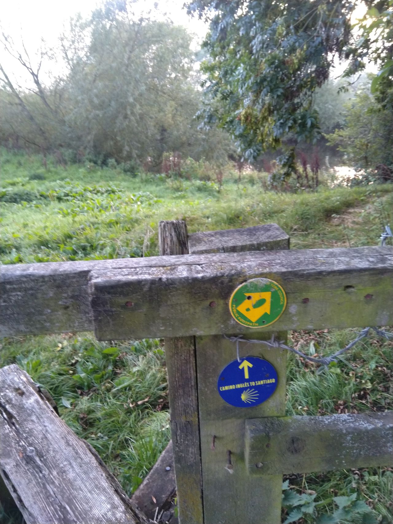
| 60786314 | almost 2 years ago | I'm guessing it's just someone with a bag full of stickers and a bit of wishful thinking - a bit like the "Camino Ingles to Santiago" (sic) at relation/14638771 . Obviously there are dozens of "official" Camino routes (see e.g. https://caminoways.com/camino-ingles ) but those stickers in Yorkshire don't match anything that I've found on the internet. I suspect that your "Jerusalem Way" might be similar. |
| 60786314 | almost 2 years ago | There are references to "a sticker" at https://threepointsofthecompass.com/2022/02/12/trail-talk-the-miners-way/ . No idea if you can tell whether that sticker is yours!
|
| 86143474 | almost 2 years ago | I'm guessing that perhaps relation/11167888/history shouldn't be "historic=ty", but what should it be? |
| 82209929 | almost 2 years ago | Another puzzle - "historic=tower" on relation/10837218/history seems unlikely - or have I just misunderstood what it is? |
| 75320271 | almost 2 years ago | Hello,
|
| 146530302 | almost 2 years ago | Thanks! |
| 145540046 | almost 2 years ago | Hello meongseolin, I changed the admin level of Somaliland from 2 to 3 previously, so I can answer this. The way that disputed territories are handled in OSM can be seen at https://osmfoundation.org/w/images/d/d8/DisputedTerritoriesInformation.pdf . When we last discussed the status of Somaliland, there were things in its favour (largely economically independent from Somalia) and things against (recognised as independent by almost no-one internationally). Before we make top-level changes to things like this, it’s important to discuss them - https://community.openstreetmap.org/c/general/38/none would be a good place to do that. Best Regards,
|
| 146509566 | almost 2 years ago | Also ts0608b, ts0617b |
| 145662783 | almost 2 years ago | I've checked - there's nothing here. |
| 135323508 | almost 2 years ago | |
| 90866934 | almost 2 years ago | See forum thread https://community.openstreetmap.org/t/someones-added-building-plots-as-buildings/101306 |
| 145366078 | almost 2 years ago | szia d zsolt!
|
| 145366078 | almost 2 years ago | Hello zsolt d,
|