Land Use Is Useful, Not Cosmetic - A Tale From an End User
Posted by Some Amateur on 7 November 2024 in English.It was a bright sunny afternoon in Ohio, but it was getting hard to tell from the smoke in the air.
Our Volunteer Fire Department was dispatched as mutual aid to fight a brush fire that had already burned dozens of acres. Once we got to the staging area and offloaded our brush unit side by side, I hopped in the shotgun/co-driver seat and we ventured into the woods to slowly find our way to the fire. Cell reception became practically non existent as the already mediocre network got bogged down by residents checking on each other. With sat imagery unable to load I thought OSMand and it’s offline data would be able to help us out.
We were making our way past a large pond that would prove to be a vital real world landmark for our vehicles moving to and from the fire. Even though land use was mapped I couldn’t see any useful terrain features. At one point in the past an OSM mapper simply marked the whole area as a big block of “Natural Wood” and moved on. I had to manually pin the landmarks in OSMand to give us bread crumbs to follow.
After a few hours and several hundred gallons of water being shuttled to the fire it was getting dark, but we could see the flames were no longer making progress. A county drone was now buzzing overhead and the operator confirmed that the fire was blocked by a swathe of wetlands. More fire units were stuck on the other side of it since it seemed like the fastest way to the fire from the opposite street, and they had to find their way around.
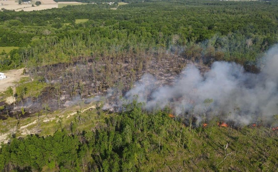
The fire burned a total of 70 acres (.28 square km) and smoldered for several more days. I went into OSM and edited in the ponds and wetlands that were overlooked and started to add more detail to already mapped land use in other areas. Any time I edit land use I try to keep the lessons I learned that day in mind.
And I get it. This is openSTREETmap. Roads take precedence because that is the use case for most people. But the moral of the story here is if mapping land use is the goal, the mapper is no longer serving that majority use case. It shifts to the realm of hikers, hunters, mountain bikers and Search and Rescue teams. Where turn by turn becomes landmark to landmark. Ponds, towers, creeks and leaf type (broad vs needle) help a lot when getting around off trail.
Detail is important when mapping natural features, because we never know who will end up relying on it!
Discussion
Comment from !i! on 11 November 2024 at 09:12
Hi, thanks for the article and of course great respect for volunteering as firefighter! As you wrote, I always try to imagine what might be possible with rich detaiped objects. But yes I also can somewhat und erstand critics on micromapping. I guess time will show which lervrl of Detail and is useful on global (Or different local?) coverage :-)
Comment from Pieter Vander Vennet on 11 November 2024 at 17:23
It started as OpenSTREETMap, but IMHO it is time to rename it to OpenWORLDMap or something ;)
And the rules to add something are simple: it has to be verifiable and somewhat permanent. If wetlands and landuse are important to you, by all means, add it to the map!