
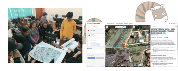
Mapping and data optimization of routes and stops of the PumaKatari municipal transport, nearby pedestrian and cycling routes, in the city of La Paz, Bolivia
Posted by SilvEsth on 20 December 2025 in English.Irpavi 2 South Route
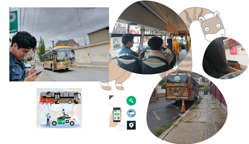
The city of La Paz, Bolivia, has the Puma Katari public transportation service, which covers the 9 macro districts and is currently deployed through 10 routes. Since its launch, this service has been a great promise, offering benefits such as preferential treatment for people with disabilities, children and the elderly, in addition to allowing the transport of bicycles in the front compartments of the buses, thus encouraging the use of this means of transportation. ecological. We are often traveling to different places in the city to carry out our field work. We know that some visitors or even people who know about this transportation service face difficulties because they do not know which route to take or where the stops are, especially when trying to reach peripheral areas.
We have had the experience of looking for a PumaKatari stop and, when trying to find it, the navigator pointed us to a location that, upon arrival, we discovered was no longer in use. This made us wonder: how reliable is the information we are using? As connoisseurs of OpenStreetMap (OSM), we decided to investigate if the PumaKatari information was updated on this platform.
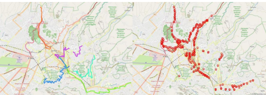
Upon further investigation we found that the information available in OSM of this area presents inaccuracies in some data and a lack of updated data on routes and vehicle stops of the PumaKatari municipal transport
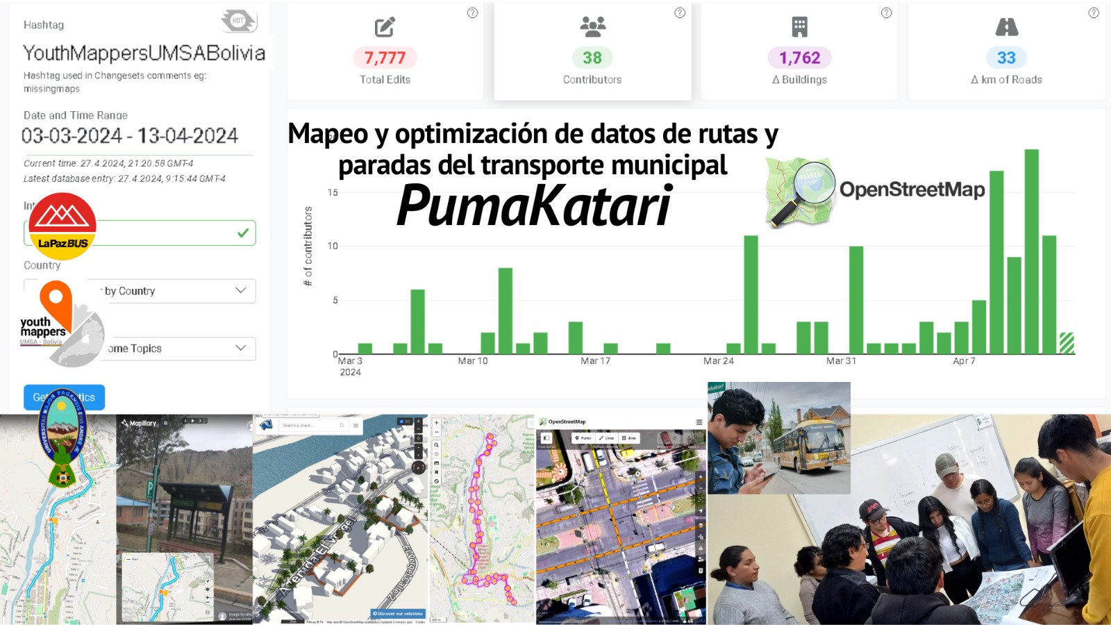
As of November 2023, it could be seen that on the OpenStreetMap platform. Of the 10 PumaKatari routes, only 5 are mapped in OSM, that is, barely 50%. And of the 603 stops that exist, only 288 are registered (48%), and many of these are incomplete or imprecise.
It was also noted that very few pedestrian routes (sidewalks) and bicycle routes are mapped, in some sections, in a disconnected manner. It seems that the mappings have been done in isolation, without clear coordination. so it is a project worth undertaking to make the lives of all of us who move around La Paz easier.
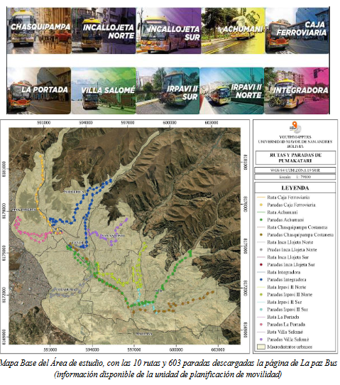
Through an investigation in the pages of the mayor’s office, we identified a reliable source that details the routes taken by this transportation system. We downloaded the information available on the mayor’s Mobility Planning Unit page and compared it with the information available on OSM.
Area to be mapped
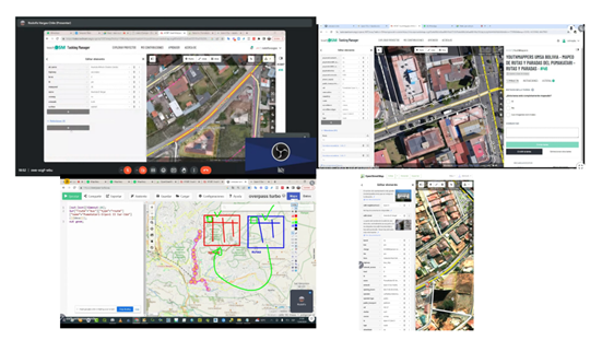
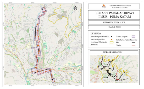 To address this problem, the Irpavi II South route was selected as a pilot area for mapping and updating in OpenStreetMap. The map shows the round trip route as well as the area covered by the mapping. During the process, PumaKatari stops were downloaded from OSM, but it was noted that some were not recognized due to lack of uniformity in editing.
The black dots represent these stops, while the orange dots indicate the stops downloaded from the City Hall platform. This highlights the need to update OSM to accurately reflect all stops on the Irpavi II South route, ensuring the integrity of public transport information.
To address this problem, the Irpavi II South route was selected as a pilot area for mapping and updating in OpenStreetMap. The map shows the round trip route as well as the area covered by the mapping. During the process, PumaKatari stops were downloaded from OSM, but it was noted that some were not recognized due to lack of uniformity in editing.
The black dots represent these stops, while the orange dots indicate the stops downloaded from the City Hall platform. This highlights the need to update OSM to accurately reflect all stops on the Irpavi II South route, ensuring the integrity of public transport information.
Purpose
This project not only seeks to update and add information in OpenStreetMap, but also to correct the lack of standardization observed. We will map pedestrian and cycling routes close to those of PumaKatari to provide safe infrastructure and encourage cycling. Additionally, the project will encourage community participation in the use of sustainable transportation and will train YouthMappers-UMSA youth in mapping and updating data. In a meeting to present the project to the mayor’s office, we were informed about an application that already included stops and routes, although some of us were not aware of its existence. We saw that outside of this application, the information is not updated and available in other browsers. With the aim of contributing positively to the city that has welcomed us, we hope that our initiative will help improve the distribution of transportation information in the community. To strengthen our project, we contacted Trufi Association, who have extensive experience in developing mobile applications for urban transportation and in route mapping in OpenStreetMap. During a visit to the department of Cochabamba, they welcomed us and They kindly shared their experiences with us. They also provided us with a course with the necessary tools, which helped us improve our implementation of this project.
Methodology
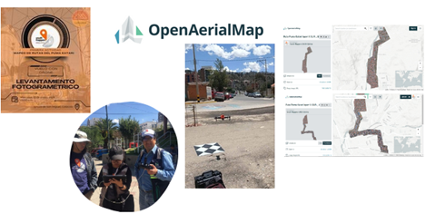
- Photogrammetric Survey The first phase of this project consisted of carrying out the photogrammetric survey of the Irpavi II South and PumaKatari route using a UAV aircraft, as well as carrying out the corresponding photogrammetric processing. First, we used a drone to capture aerial images of the PumaKatari’s Irpavi 2 South route and process them to ensure they were accurate. These images were uploaded to OpenAerialMap
 2. Data Collection: IRPAVI II Route
 In the second stage, we collected data in the field using the StreetComplete application to identify the type of road surface, verify if it had sidewalks and lighting, and generate notes for filling out data at each of the stops. In addition, the presence or absence of sidewalks could also be recorded in the data collected with StreetComplete.
Using the Mapillary app, we captured the round trip, documenting both the left and right sides of the road.
3. Remote Mapping
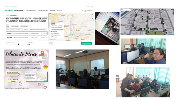
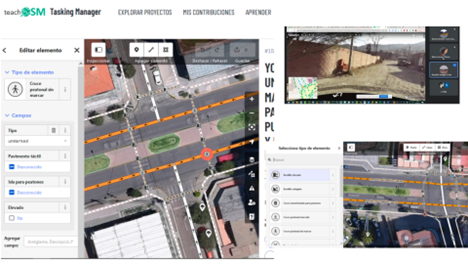
With the aerial images already published in OpenAerialMap, two projects were created on the TeachOSM Tasking Manager platform, taking advantage of the advantage of being able to directly link the aerial photographs that we uploaded to OpenAerialMap in Tasking Manager.
The first project focused exclusively on mapping roads and stops, while the second focused on mapping houses, buildings and infrastructure, in order to make the most of the images captured by the drone.
To begin the work, it was necessary to carry out training in which the purpose of the project was shared.
In the second stage, we collected data in the field using the StreetComplete application to identify the type of road surface, verify if it had sidewalks and lighting, and generate notes for filling out data at each of the stops. In addition, the presence or absence of sidewalks could also be recorded in the data collected with StreetComplete.
Using the Mapillary app, we captured the round trip, documenting both the left and right sides of the road.
3. Remote Mapping
With the aerial images already published in OpenAerialMap, two projects were created on the TeachOSM Tasking Manager platform, taking advantage of the advantage of being able to directly link the aerial photographs that we uploaded to OpenAerialMap in Tasking Manager.
The first project focused exclusively on mapping roads and stops, while the second focused on mapping houses, buildings and infrastructure, in order to make the most of the images captured by the drone.
To begin the work, it was necessary to carry out training in which the purpose of the project was shared.
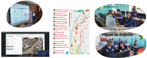 Finally, we trained the YouthMappers-UMSA community to accurately map routes and stops on OpenStreetMap, including nearby walking and cycling routes.
 For mapping routes and stops, we add essential information such as the cost of the service, the operator, the type of payment and the schedules.
We also record the type of road surface, which varies along the route. As for the stops, we note if they have seats, trash cans, umbrellas and if they have lighting. Additionally, we document the number of lanes and their direction.
For mapping routes and stops, we add essential information such as the cost of the service, the operator, the type of payment and the schedules.
We also record the type of road surface, which varies along the route. As for the stops, we note if they have seats, trash cans, umbrellas and if they have lighting. Additionally, we document the number of lanes and their direction.
 By mapping pedestrian paths and sidewalks, we were able to identify several important aspects, such as whether they had raised or lowered curbs, whether the pedestrian crossing was marked or not, and whether there were pedestrian paths. In remote places on the outskirts, we even notice the absence of sidewalks. This mapping is very important to guarantee accessibility, especially for wheelchair users, and to evaluate the accessibility of establishments.
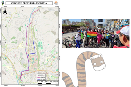
 Although the initial objective was to map bike lanes, the route selected for mapping does not have a complete bike lane circuit. However, there are small sections of cycle paths that are only enabled on weekends.
Considering the importance of this means of transportation, we generated a proposal for a cycle path circuit. Our colleagues who live in this area helped us prepare it, taking into account two ways that could be considered for its implementation.
Although the initial objective was to map bike lanes, the route selected for mapping does not have a complete bike lane circuit. However, there are small sections of cycle paths that are only enabled on weekends.
Considering the importance of this means of transportation, we generated a proposal for a cycle path circuit. Our colleagues who live in this area helped us prepare it, taking into account two ways that could be considered for its implementation.
Getting into Risk Mapping
During the development of this project, in March of this year, the Irpavi and Arumthaya rivers overflowed due to the rainy season. This event occurred very close to the area selected for mapping.
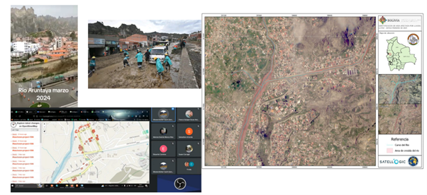 Therefore, we could not be indifferent to this situation. We carry out a mapping of risk labels. Adele Birkenes and Rory Nealon provided us with the necessary guidelines for adding flood vulnerability information to OpenStreetMap, telling us what tags we could use to note that a stretch of street has been damaged.
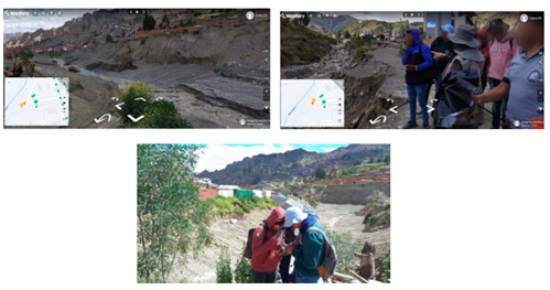 With the support of Dr. Yuri Sandoval, Rodolfo Vargas and the members of the chapter, verification of the field work for data collection in the affected area was carried out. The collapse of streets, landslides, dragging of material and the increase in the flow of rivers were observed, which affected local roads and homes built near the tributaries.
Taking this into account, the nearby homes that were already mapped, along with the georeferencing of the field work we carried out, allowed us to add the necessary labels.
With the support of Dr. Yuri Sandoval, Rodolfo Vargas and the members of the chapter, verification of the field work for data collection in the affected area was carried out. The collapse of streets, landslides, dragging of material and the increase in the flow of rivers were observed, which affected local roads and homes built near the tributaries.
Taking this into account, the nearby homes that were already mapped, along with the georeferencing of the field work we carried out, allowed us to add the necessary labels.
Conclusions
 Mapping routes is crucial for both the local community and visitors. Delving deeper into mapping roads and sidewalks, especially for people with disabilities, and mapping hazards, was an unexpected but indispensable added value. This approach allowed us to better understand its importance and provided valuable guidelines for future projects.
It has given us a clear picture and excellent guidelines to move forward. The satisfaction of having generated a detailed database of the identified stops and having developed a clearer methodology to structure the process motivates us to continue with the next routes. Being part of the projects selected by Latin American MicroGrants has been a wonderful experience. We were able to appreciate the diversity of approaches in open access mapping and share our work at the YouthMappers presentation at Cafecito. We learned about other incredible projects in the region and reinforced our interest in continuing to map. It motivates us to continue with more projects that contribute to improving our city and inspire more young people to learn about these tools and discover how they can become agents of change.
Acknowledgments
Special thanks to:
-
To the regional ambassadors youthmappers 2024, who provided us with suggestions at every stage. Thank you for giving us the opportunity to launch this project and for supporting us through each phase.
-
Having an insight into the work that Trufi Association does in Cochabamba was very important. Through knowledge of their methodology and the use of open data, we were able to significantly improve our efforts.
-
To our collaborator, Rodolfo Vargas (member of OSM Bolivia), for his constant updates on OSM tools; his trust and generosity were essential to the project.
Discussion