Alpine Ski World Championship meets OpenStreetMap: Who are the Mapping Champions?
Posted by SGroe on 17 February 2017 in English.These days, every ski enthusiast keeps an eye on St. Moritz (Switzerland), the host of the Alpine World Ski Championship 2017. As ski and map enthusiast, one of my eyes is always on skiing while the other is on mapping as well, more specifically on community mapping with OpenStreetMap. While watching ski races on TV, I had the idea for taking a closer look at skiing-related features in OpenStreetMap, in particular on the St. Moritz resort, but also skiing resorts worldwide. In this blog post, I conduct an analysis on OpenStreetMap features related to alpine skiing, revealing the evolution of aerial lifts and ski pistes. Following the spirit of the ski world championship, I award gold, silver and bronze medals to outstanding OSM contributors.
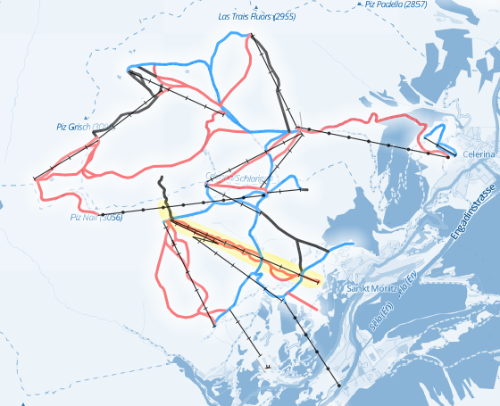 Pistes and aerial lifts at the Corviglia-Marguns-Piz Nair winter sports resort at St. Moritz, Switzerland, host of the 2017 Alpine Ski World Championship (WC) (Map data and background: © OpenStreetMap contributors; yellow area indicates WC race pistes)
Discussion
Comment from SK53 on 17 February 2017 at 21:05
Hmm, a shame one of the medallists appears to be adding fantasy ski runs in the Engadin area.
Comment from SGroe on 17 February 2017 at 23:04
I have already learnt about him and will pass the medal on to the next contributor after the weekend.
Comment from SGroe on 20 February 2017 at 12:00
mgeiser and Schnappi inherit Silver and Bronze medals for mapping alpine skiing pistes in St. Moritz.