
Cho-do, modern and ancient mapping of a North Korean island
Posted by Koreller on 1 December 2025 in English.Sometimes some maps are more satisfying than others. What I did on “Cho-do” (“초도”) — Cho island — is definitely one of them!
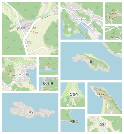
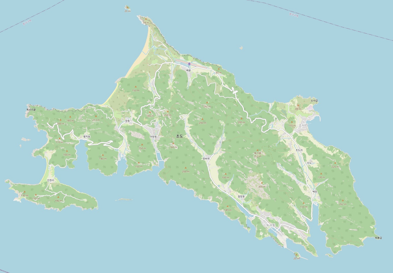
Cho-do in North Korea is one of the largest islands in the country, and today we can proudly say that it is fully mapped on OpenStreetMap!
In this diary, I explain the small steps I had to take to achieve what I consider to be — among the various places I have mapped — the most complete area !
See it directly on OpenStreetMap!

Why an island?
I have been able to map various locations in North Korea (and a few other places), but there are few areas that are as well-defined as islands — which are not too large either — to map completely.
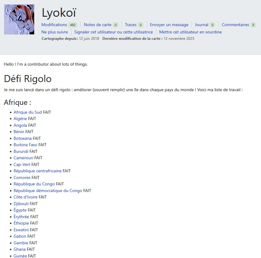
The idea of doing an island came to me from a contributor, @Lyokoï, who plans to map at least one island in every country/territory in the world. I love the idea, but if I were to take on this kind of project, it would be to map all the islands of North Korea 🤭!
As a mapper focusing primarily on North Korea, I absolutely had to do an island in that country.
There are not many islands in North Korea, and the largest ones are reasonably sized — Cho-do is about 10 km long and 3 km wide — so I chose it and began mapping it in late September 2025.
Mapping method
As always, when I want to map an area in detail, I start by redrawing everything, in this case for Cho-do: the coastline, highways, and few buildings already present.
Next comes the stage of mapping the most useful elements, all the roads and paths, buildings and POIs, followed by landuse mapping, starting with the wooded areas.
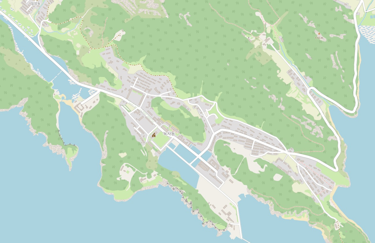
It’s when I’m doing farmland landuses that I sometimes start wanting to do all the other landuses that are harder to identify (scrub, grassland, bare_rock, sand, etc.), and that’s what takes the most time, in my opinion.
Old map from the Army Map Service (AMS) and data from the National Geospatial-Intelligence Agency (NGA)
What is unique about mapping this island is that I was able to use external data. It is quite rare to be able to do this, but thanks to old maps from the Army Map Service (AMS) and data from the National Geospatial-Intelligence Agency (NGA), it is possible!
The NGA datas and AMS maps are both in the public domain, because there are work of the US federal government, so it is fully compatible with the ODbL license.
The old AMS maps date back to the Korean War (around 1950) but can be a valuable source of certain information.
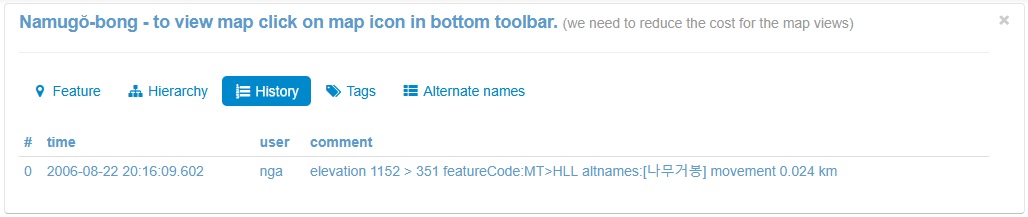
To navigate through NGA datas, I use the GeoNames/v3 website (see the wiki), simply zoom in on the desired area, but be sure that the data comes from the NGA: to do this, click on each point and look at the history to see if the author is indeed the “nga” (in North Korea, I have rarely seen other authors in GeoNames data).
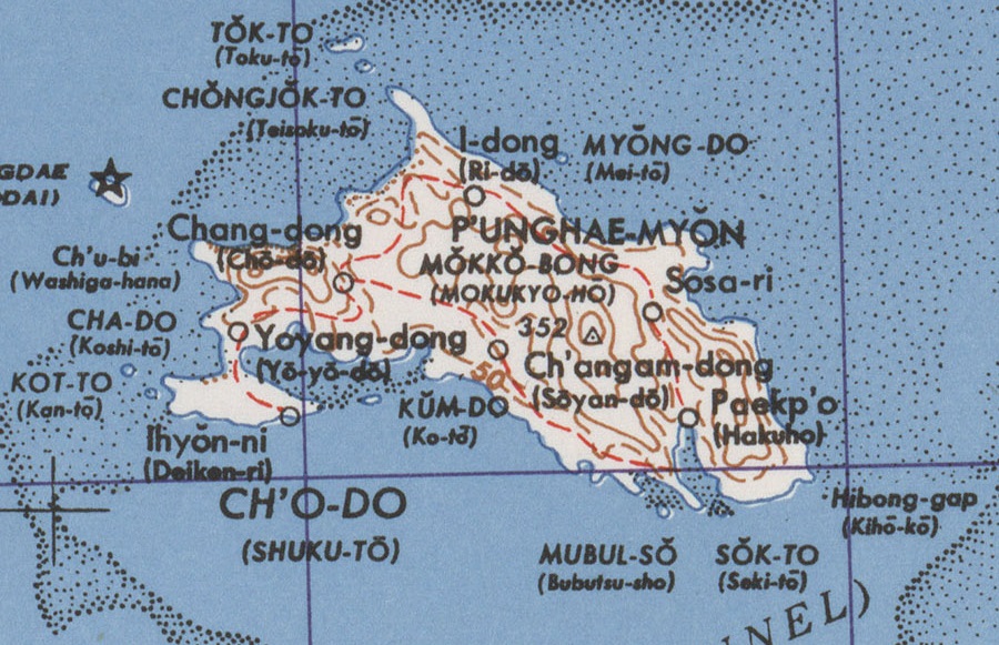
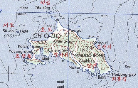
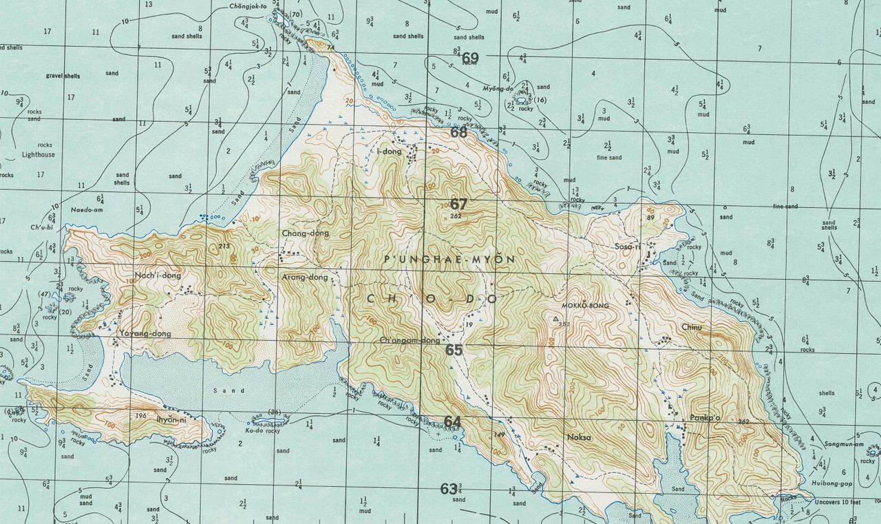
Searching for the US Army Map Service (AMS) map at a scale of 1:50,000
After mapping most of the things that could be seen from satellite imagery, it was time to use the old AMS maps.
Online maps from University of Texas and KoreanWar website
I thought it would be easy to find the map of the area I was interested in — because I knew about the excellent website of University of Texas with Korea Maps — but it would have been too simple.
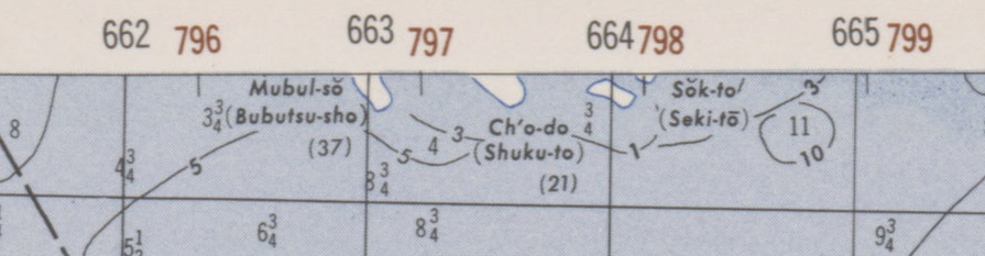
The map I’m interested in is obviously the most accurate one, the 1:50,000 scale map in the L-751 series, which bears the sweet name of “6129 I”.
I found the sheet describing the area just below, “6129 II”, but no sheet “6129 I”…
So I had to go further, and I found another very good website: Korean War, which lists the different sheets in the L751 series, but again, no “6129 I”…
After more searching, I still can’t find it and I’m starting to get a little discouraged. I reassure myself by telling myself that there are still other interesting old maps from other series, even if they are less detailed because they are on a larger scale, in particular:
The power of OSM community
This is when mutual support within the OSM community becomes invaluable.
With Telegram, I requested assistance from @adreamy — a Korean contributor — who ultimately locates the map in the Korean Archives, in black and white.
I was so happy to finally have it!
Then, even better, following my request on Discord, @Minh Nguyen — a contributor from the United States — finds me the perfect map in US National Archives, in color, with maximum quality!
Thanks again to both of you!
Additions with the detailed AMS map
Thanks to this “6129 I” map — finally found — I was able to add various objects!
First, I was able to enter the names of the small islands around it, then the altitude of some mountain peaks, the names of the villages, the location of the cliffs (because with satellite imagery it’s a little too difficult to determine which are cliffs and which are not), and finally, the names of the capes and name of the highest peak.
Add to that a few improvements to Wikidata elements (with the help of WikiShootMe, which displays the geolocation of Wikidata elements, which is very useful for finding out what exists in an area), and we’re good!
Altitude of the peaks
To determine the altitude of the peaks, I first used SRTM elevation curves (NASA data from the 2000s) to indicate the (minimum) altitude of the various peaks, but this is not exactly the same as the AMS information (which dates from 1950).
For example, the highest peak on the island, Mokkŏ-bong (node/13189632157), is indicated at 350m on the AMS map, but the SRTM data indicates this peak to be between 320m and 330m.
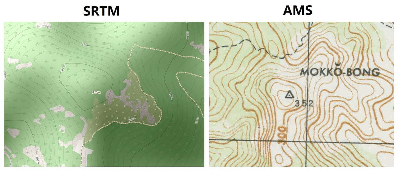
In your opinion, which would be the best source: NASA technology from the 2000s or the US Army Map Service systems from 1945-1950, which flew over the area and probably went out into the field?
For now, the map is a mix of both, I entered the AMS values, and when the AMS didn’t have any, I used the SRTM, but I systematically specified the source with the key source:ele.
Time spent
Although it’s difficult to estimate, I think it took me 30-40 hours to completely map this island. I started at the end of September 2025 and finished in mid-November 2025. In the meantime, I mapped other things elsewhere, but these are the dates of my first and last changesets on the island, respectively.
A Wikipedia article
![]()
I created the French Wikipedia article for the island, but only by translating from other language versions (Korean, Swedish, Cebuano), as very little information is available. By “very little”, I mean “even less than usual”. I imagine that the partly military nature of the island explains this.
Furthermore, research is made all the more complicated by the fact that another island in South Korea is also called “Cho-do” (“초도” in both cases 😓) (relation/11582489# map=14/34.23091/127.25918), for someone like me — who doesn’t speak Korean — it’s mission impossible!
Satisfaction
It’s so enjoyable and satisfying to completely map out a well-defined area like this island! I hope you appreciate my work on this OSM map 🙏!
osm.org/#map=13/38.53272/124.83164
Discussion
Comment from Omnific on 1 December 2025 at 16:05
Wow, what an amazing job, and a great write-up! Really impressive!
Comment from KennyDap on 3 December 2025 at 07:48
Really cool work! I’m a little jealous, since I’m also working on islands, but in South Korea. I’ve been watching your work for a while now, and you really nailed it very quickly! Sounds like a challenge :)
Comment from wildmaps on 7 December 2025 at 11:40
Impressive work — compliments!