
Phewee. I was expecting to have a long quiet somewhat boring christmas back home in Yorkshire, during which I would surely get time to do lots of OpenStreetMap things I've been putting off. It didn't really turn out that way. It was quite a busy house, with 11 people back home at one point. Siblings invited partners and other guests, and the crowdedness contributions following a long tail distribution with me comfortably in the high-to-middle-ground. :-)
Some things I did manage to do:
- Talked to folks from the Japanese Ministry of Land, Infrastructure, Transport & Tourism. This was just before my holidays. They came to visit me in my office. Amusingly they were fresh off the train from visiting Ordnance Survey down in Southampton. Before they arrived I mashed together several of my slide decks to produce an updated general OpenStreetMap deck covering various angles. I ran through that with a translator, and they gave me japanese presents!
- A bit of asking users to accept the ODbL. I fired off just a couple of emails to local contributors in West Yorkshire, customising the message to refer to their contributions.
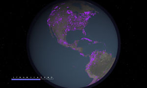
- Remote mapping of Nagpur, India (map). Added a few more missing roads from bing, but I kept getting distracted by rivers. Lots of beautiful big rivers to sketch in in India. My mum's off on a trip to Nagpur for two months, so I thought I'd try to improve the map there a bit. My plan was to load maps onto her new kindle, but didn't actually get as far as figuring out the best way to get them on there
- I finished writing my chapter (about OpenStreetMap) for a book which I'll tell you more about some other time. I also roped the whole family into proof-reading. Still some illustration and formatting (and learning LaTeX) work to do on that
- And of course blogging: fund-raiser target reached! Hurrah! It was my pleasure to do this on Christmas day.
So that was my Mappy Christmas, but wait... what about the OpenStreetMap Christmas Party?


(More lovely photos from Alex)
We went to Ye Olde Cheshire Cheese pub. I found Tim Waters (visiting from Leeds) down in the deepest level, two storeys down. We joked that maybe they were working on excavating the floor below to extend the pub downwards. This pub is nice and cosy in medieval sort of way, even in the lowest stone cavern. It was weirdly crowded on a Saturday at 4pm, perhaps because it makes a fine shelter from bleak weather and the christmas shopping mayhem.
Ed Freyfogle came along. He brought glad tidings and Christmas cheer by telling us that nestoria (the property search engine) had decided to ditch google maps and use OpenStreetMap instead. This was prompted by google's new pricing regime for the heavier website map users. Instead they've switched to use mapquest open tiles (OpenStreetMap maps rendered and served by MapQuest) and mapstraction with leaflet for the javascript side of things.
Mapstraction could be a good route for people seeking to simplify a switch, but I have a question which Ed didn't know the answer to: If you were to use google maps API (the javascript library) but define a layer so that your site visitors are fetching all the map tiles from another tile server (as in our OpenStreetMap Google Maps Examples), then this involves less switching effort, particularly if you have built a bunch of google maps specific marker/polyline/event handling functionality, but would this avoid the new google usage level charges? To me it seems logical that it would, but Ed suspected not because of the way google talks about measuring in "map views".
In any case the switch by nestoria is great news, and made more so by the blog write-up which Ed did: Why (and how) we've switched away from Google Maps which then got picked up by various news outlets such as forbes, technologyreview.com, and techdirt. In the Communications Working Group we've been pondering how to get OpenStreetMap better recognised in the press (suggestions welcome), but you can't force these things. An occurrence such as the nestoria switch is often the trigger, which prompts journalists to take a surprised look at how awesome OpenStreetMap is.
As you can see in the photos, later on Derick provided christmas biscuits! And we even got a table eventually.
Speaking of Derick... he's been busy with a mappy christmas himself. If you didn't already see his gorgeous video: 'OpenStreetMap: A Year of Edits 2011'... check... it... out... preferably in full screen, and preferably with the music.
It's similar but a little different to the ITO world year of edits 2008. One key difference though: made entirely out of free and open source software! Details from Derick about how the video was made, on his blog.
I feel all fired up for an OpenStreetMappy 2012! So how about another pub meet-up? We'll kick off for the year next week on Thursday 12th at the Monkey Puzzle: All the details. We're expecting a rare appearance of the water-dwelling Richard F. Join us!
Discussion
Comment from skorasaurus on 5 January 2012 at 22:54
As far as I know, the only kindle maps that use OSM are at: http://www.kindle-maps.com/
Comment from Harry Wood on 5 January 2012 at 23:13
Yeah I was expecting that site to help me, but actually it only has pre-made maps of London, Dublin, Glasgow, Edinburgh and New York. Can a kindle download and display a PDF file? If so, how well does it cope with the output from Maposmatic? and wasn't there an option to do multi-page atlases with Maposmatic? I started playing around with this, but didn't get very far.
Comment from Former OSM contributor on 6 January 2012 at 12:54
If the likes of Nestoria are switching to OSM we'd better get our fingers out in the U.K. as there are large holes in the road network according to ITO http://www.itoworld.com/product/data/osm_analysis/main. Their stats show the following (6th Jan 2012):
Roads In OS Locator 855,634
Roads Missing from OSM (major) 118,500
Roads Missing from OSM (minor) 4,474
UK Percentage Complete 86.21%
Missing change last day -269
Missing change last week -2,329
Missing change last month
Leeds has 3200 roads missing, Bradford >3500. I know I've been guilty of doing the fiddly bits around the area where I live but do try now and again to look around other areas where I can feed into the map roads that aren't drawn or where they are but unamed.
Comment from Andy Allan on 6 January 2012 at 18:18
The google maps charges are per map view as counted by loading their javascript library - so if you keep loading their library, that counts as a chargeable page view regardless of the tiles.
I think Google (quite rightly) see loading their api, which contains tiles, hooks for geocoding, streetview etc as the main thing to be concerned about.
Comment from Harry Wood on 6 January 2012 at 19:23
Well Ed was also saying that the google salesman couldn't point him at any instrumentation show how far over the limits he was, but maybe they'll make this clearer at some point.
If they were charging based on how much it costs them to serve the maps, surely it would make most sense (purely from an engineering standpoint) to count up requests coming into those expensive services (tiles and geocoding).
But then again that makes for a charging scheme which doesn't match the way web designers think of 'page views', and google already has mechanisms to enforce access to their tiles only via their javascript (though I don't actualy know how that works. Some sort of token exchange?)
If one user pans and zooms around an awful lot, does that cost the same as somebody making a fleeting glimpse? All very mysterious. So you reckon big sites definitely have to switch away to OpenLayers or Leaflet to avoid the charges? bummer ....hurray for Mapstraction!