
During the recent HOT chat, when we talked a bit about the aerial imagery in Somalia, I was giving my simplistic understanding about what bing and yahoo do through most of Africa, and any other parts of the globe where they haven't spent a bit extra on high resolution imagery. Basically they use landsat; the public domain satellite imagery from NASA. Landsat is certainly better than nothing, but limited in resolution such that towns are fuzzy blobs and you can't really see any roads (none but the largest motorways) Bing and Yahoo immediately look different from landsat because they apply their own colour enhancements, or perhaps correct the colour enhancements nasa applied. But they're all landsat right?
I thought I'd check this, and quickly realised that it wasn't the full story. I took a look at the southern end of this lake near Jilib. By the way, this lake is shown on OpenStreetMap but not google or yahoo maps, and inaccurate on bing. Win! But what about in the imagery...
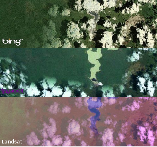
For the bottom landsat view, I'm using "Landsat (Mirror)" in JOSM which is coming from a http://irs.gis-lab.info/ URL. So landsat has some weird purple colouration going on, and clearly there's some cloud obscuring this particular part of the globe. In both bing and yahoo we can see the same cloud (in the same formation) obscuring the view.
But the really interesting thing is that yahoo seems to have fuzzed in a different bit of imagery giving us a clear view of the lake. So we're not looking at identical imagery sources with just colour difference. Bing also has a clear patch to the west, but not in a shape which includes the lake. Compare Yahoo imagery with bing imagery.
With Yahoo it actually looks like somebody has manually fuddled it to give us a clear view of the lake. It's not a clear boundary with some other imagery set. It's merged in as if this was done during the early phases of constructing a layer from satellite readings. Maybe yahoo are just showing landsat data from different dates. I'm not sure how often landsat data gets refreshed, or how they manage to patch it together to try to avoid clouds. Would love to know more.
One clear finding from this, is that even ignoring the different pockets of high-res availability, Yahoo are currently providing OpenStreetMap with some different low-res satellite imagery, and some of this may be superior (no clouds) to bing's. This happens in little pockets which could crop up anywhere on the globe.
If we want to make use of these pockets of Yahoo goodness, then we dont have much time left. In September yahoo are reprioritizing their portfolio of products and services. Of course low-res imagery isn't much use anyway. Good for tracing around lakes though. The main concern with this ticking clock remains the loss of access to high res areas such as Pakistani cities which are in Yahoo but not in bing.
I've done a little speculating here. All I have to go on is my own exploration of the imagery. Does anyone else know more about the low-res imagery of bing and yahoo?
Discussion
Comment from Komяpa on 18 August 2011 at 10:08
Well...
Landsat itself is not an RGB (visible light) thing. It has somewhat like 7 channels, and ~3 are in visible part of spectrum.
And also, it comes not in form of "one big image for all the planet". It's all a lot of shots, that keep coming from satellite - it updates the view of all the planet somewhat like twice a month. Only some of that data is public domain, the realtime stream isn't. (The access to realtime stream was given to OSM previous year during fires in Russia, but almost noone cared and it was closed again).
You can stitch this images in different ways, choosing different parts of spectrum as your green, red, and blue channels, or even making them follow different equation. You can even download raw geotiff for the area from NASA and set up your own custom WMS, with your own alignment and coloring.
Comment from Zverik on 19 August 2011 at 05:55
What's nice about our Landsat layer, it is made not of visible spectrum channels, but of other, more useful ones. As you could have noticed, lakes, forests and fields are more easily distinctive on our Landsat, compared to the Bing and Yahoo ones, for example. Also, clouds are irrelevant: as you see, on landsat layer they are transparent, because the channels we use are different from visible spectrum.
Comment from Harry Wood on 19 August 2011 at 09:24
This is interesting stuff. We should update the Landsat wiki page with some more information. I notice that page lists the different layers you mentioned as part of 'global mosaic'. It seems they used to be available and viewable as separate WMS layers. Does anyone know if it's possible to get these into JOSM from oneearth via a tiled WMS request? The oneearth site suggests it might be.
So it seems like yahoo and bing are using a different composition of these layers, and also using different landsat scenes taken from different dates. Either that or they simply took a global mosaic snapshot from a different date. So what exactly is released PD from the federal government? The global mosaic?
Comment from Komяpa on 19 August 2011 at 20:24
Different scenes are released. Everyone mosaics them themselves, making a "commercial product". Well-rectified landsat mosaic can even be used to align hirez imagery.
Some of those mosaics are PD-licensed, like the one on onEarth which is proxied by small script on gis-lab. They have that mosaic in form of 7 different layers that can be composed in any way (Lakewalker used their IR layer, you can see URLs in code). But JOSM devs (and other apps') ignored their request to access mosaic in tiled way, so server was overloaded and they had to switch it off.
Again, you can take raw scenes, rectify and make your own WMS, even on local machine. :)