GOwin's Comments
| Post | When | Comment |
|---|---|---|
| Geoweek Mapping Party with Grab, MapPH, and OSMPH |
Interesting. How do you intend to use this data, where can we get more information about your project, and where do you intend to publish the results? |
|
| Geoweek Mapping Party with Grab, MapPH, and OSMPH | Kudos! Which Tasking Manager instance is this on, Feye? |
|
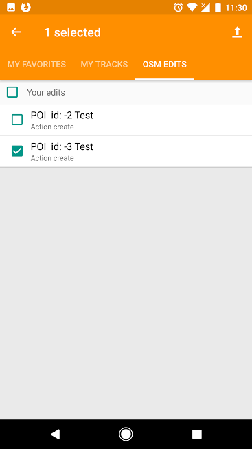
| Editing in OSMAnd | OsmAnd is also a favorite editor on Android. You can add multiple POIs in a single changeset, what you do is to simply continue adding the POIs without uploading each individually, and when you’re complete, go to Menu > My Places > OSM Edits where you’ll see all the saved edits you’ve made. You can choose what to upload, or select everything. You leave any appropriate changeset comment that describes the edits you just made, and then optionally close the changeset. Once you hit ok, you can no longer modify a changeset comment.
|
|
| The only phone that doesn't like cobblestone | Great tip! Thank you. |
|
| Maps, Kids and Humanitarian Outreach | Thank you for sharing! But why are you copying and pasting content, when you could have simply shared a short summary, and a link to the original site with richer content? https://media.ifrc.org/innovation/2017/07/03/maps-kids-and-humanitarian-outreach/ Anyway, “whiteboard mapping” is an interesting approach. I hope we could try that out ourselves in one of our local outreach activities. |
|
| OSM Training at Eastern University of Sri Lanka in Batticaloa | From our own community experience in the Philippines, we don’t JOSM as inappropriate for beginners - provided there’s enough time to provide proper training, and guidance. The caveat is that, it’s challenging to teach it in one day (but not impossible). During any training activity, we try to remind participants that we often work with live data, so if they are unsure about their work, they can ask for assistance from workshop facilitators. So what drives our choice of editor when running OSM training?
|
|
| Get the gps coordinates for a region/state, area etc | P.S. Welcome to OpenStreetMap! |
|
| Get the gps coordinates for a region/state, area etc | Stephan is likely to be right, and you can do that next time. Check out http://bboxfinder.com . It should be able to do what you want. |
|
| New to all this | Welcome to OpenStreetMap! |
|
| Hydranten in Friedrichshafen | You may also use Overpass Turbo to extract the actual data, and do other stuff with it. Try out this query. |
|
| What is apartment complex's road? | Most likely, a combination of the following: https://wiki.openstreetmap.org/wiki/Tag:highway=service service=driveway |
|
| Translating OSM Diary entries | @SomeoneElse Yes, those two are probably the top options. Like you, I tend to switch between services, depending on provides better contextual translation. @ thermo_nuclear Сны-они свободны! ;) |
|
| #geo4kids - teaching kids basic geography | Mapping from 7 to 77 - awesome! Thanks for sharing. I’d love to exchange notes and ideas with those with experiences teaching geo* to very young people. |
|
| City Mapa-thon: (San) Juan more time! |
I have no idea about that, but here’s a draft copy of the JOSM XML preset you can use. The relevant section is in shelter group. I see that you’re from FL. I hope you’re safe, and not in the path of Hurricane Irma. |
|
| How I added some vending machines in a Japan city I've never visited | Great intro to using street-level imagery for mapping! Thanks for sharing. |
|
| Collecting bus stops on foot | Wow! 42°C is a scorcher! That’s dedication! I enjoyed watching your SotM 2016 presentation on YT. |
|
| Hail Hydra(nt)! - GenSan edition | Thank you for sharing! That mobile app looks interesting, but unfortunately unavailable in our country. We use FieldPapers, or OsmAnd, and more recently, has found the OSM Contributor app very user-friendly for theme-specific field mapping. Yes, we also use those websites you mentioned for visualization. OSMHydrant is a crowd favorite. |
|
| Making the switch from Wikimapia to OpenStreetMap | This is an awesome diary entry coming from someone new in OSM. I’ll make sure to refer to it in my decks. 😀 Two years later, I’m glad that you’re still actively contributing data and effort for OpenStreetMap. 🚀 |
|
| Visapur Hiking Route | Awesome views! Thanks for sharing Must be really tricky (and slippery) to get up there. |
|
| Better Walking Papers | @Sam Wilson, the plugin is designed for an earlier version of QGIS you have in your computer. You might want to downgrade, or run a VM to try it out. |