42429's Comments
| Post | When | Comment |
|---|---|---|
| Relationen suchen - z.B. alle Radwege im Vogtland? | Ein solches Programm befindet sich gerade in der Entwicklungsphase:
Gruß FK270673 |
|
| Street just changed from two way to one way | There is one time-dependent oneway road in Hamburg (the orange one):
Currently, the syntax is:
However, I don't know whether any router can deal with this syntax. |
|
| Auricher Taxi Ruf | Telefonnummern nützen uns leider nichts, weil wir geographische Daten sammeln. |
|
| phantom street in thornbury 3071 australia needs to be removed | There seems to be a litte footpath behind the houses - is it accessible for pedestrians? |
|
| Ich habe die neue Lizenz abgelehnt | Angesichts der großen Bedeutung dieses wichtigen Themas möchte ich noch einige persönliche Anmerkungen hinzufügen: Ein Teil der CT ist leider unverzichtbar, ein Teil ist notwendig, um die Share-Alike-Bedingungen durchzusetzen. Würde man die Datenbank allen Endnutzern bedingungslos (d.h. PD) zur Verfügung stellen, dann könnten die CT etwas kürzer werden. In diesem Falle müsste in den CT der Begriff "OSMF" durch den Begriff "anyone" ("jeder") ersetzt werden. Dieser Vorschlag ist jedoch abgelehnt worden. Mit der neuen ODbL besteht die rechtliche Möglichkeit, dass einzelne kommerzielle Anwender auf der OSM-Datenbank beruhende kopiergeschützte Produkte entwickeln. Das finde ich nicht schön, aber ich lege auch keinen Wert darauf, auf dem Rechtsweg dagegen vorzugehen. Ich fände es hingegen unfair, wenn 99 nichtkommerzielle Anwender Deine Daten nicht mehr nutzen könnten, weil Du ein kopiergeschütztes Projekt verhindern möchtest. Der Lizenzwechsel hat gezeigt, wie umständlich es ist, wenn jeder Mapper persönlich seine Zustimmung zum Lizenzwechsel erteilen muss. Es wäre schön, wenn es zukünftig ein schnelleres Verfahren zur Lizenzentscheidung (2/3-Mehrheit) gäbe. Die Lizenzwechsel-Kritiker haben dafür gesorgt, dass der ursprünglich für 2010 geplante Lizenzwechsel auf 2012 oder später verschoben wird und somit ausreichend Zeit für ein Überdenken des Lizenzumstellungsverfahrens bleibt. Derzeit haben die PD-Befürworter unter den Lizenzumstellungsgegnern relativ gute Argumente, die von der Licence Working Group (noch) nicht ausreichend ernstgenommen werden. Meine persönliche Empfehlung lautet: Sei großzügig mit Deiner (nachträglichen) Zustimmung und lasse 99 nichtkommerzielle Projekte nicht darunter leiden, wenn ein kommerzieller Anbieter kopiergeschützte Karten auf dem Markt wirft. Früher oder später werden sich freie Anwendungen ohnehin auf dem Markt durchsetzen. |
|
| What am I missing? | In the United States, trunk means "surface expressway" (normally a high-speed divided highway with at-grade intersections and sometimes some interchanges) or major intercity highway.
However, the trunk dispute has lead to the first banned user in Germany (who refused to read his personal messages on the trunk/primary issue). The other issues (secondary/tertiary, unclassified/residential, service/track, cycleway/footway/path) are still disputed so far. |
|
| What am I missing? | Let me give a very long review that may take months of work to realize:
Yours, FK270673 |
|
| Coercion | OSM enables you to change your declining decision at any time. There is a draft to ask all decliners about their reasons and to negiotiate with them, but this draft has been postponed many times. > don't just delete it as some kind of public humiliation They are a afraid of a future lawsuit from decling contributors or third-party sources against OSM or any of its commercial users. With accepting, you agree not to suit the OSM Foundation for any data. With declining, you reserve the right to file a lawsuit against OSM Foundation and its commercial users for any unproper use. If you do not answer after being explicitly asked, you are losing your right for a lawsuit in English and German law (because you could have said no before, judges are doubting your real interest). However, you might try a lawsuit in France or Spain or any other country where silence does not constitute a tacit accept. In order to prevent a future lawsuit in France or elsewhere in the world, they need to delete your data at least if you have explicitly declined. It is still time to ask the license working group for a compromise that makes all mappers happy, e.g. declaring personal contributions as public domain. > By the way, what happens to the data of a contributor who has died. Presumeably that gets deleted as well? That is really an open question! Theoretically, legal heirs who inherit the account must decide on the license change. Some contributors have posted a last will that gives instructions to heirs in case of leaving early. |
|
| Pittsburgh TIGER cleanup | Good work! |
|
| MapSpot, contributor or leech? | As far as I know, JumpStart maps are considered as public domain. Their import is rather a technical matter because there is a need to eliminate duplicate data. |
|
| only on OpenStreetMap | Great to see that! Just have a look at
|
|
| One Year of OpenStreetMap | Congratulations! Your power lines in Maryland have been a good starting point for the Northeastern transmission grid!
|
|
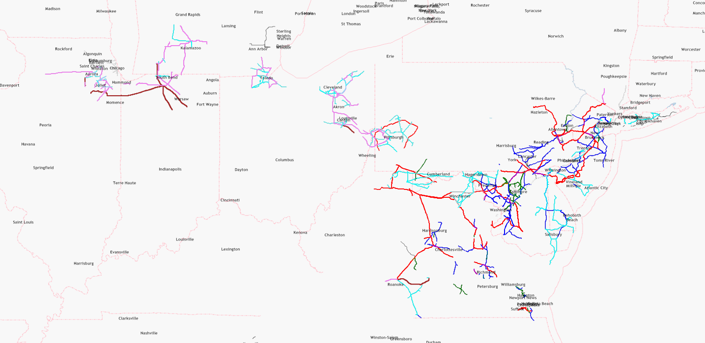
| US power lines are still incomplete | This map is intended to attract new mappers for some neglected areas. Since October 2010, this power network has grown remarkably, and each additional line may be considered as success. This map is neither a proof that black areas are perfectly mapped (Chicago has still some gaps which need to be added) nor a proof that white areas are completely unmapped. Toolserver's powermap has almost as many white spots as my simple map which I have made with Kosmos, so there must be some untouched areas. Anybody who wants to fill the white areas is welcome. Anybody who wants to leave the map as it is will be ignored. |
|
| Westover, Arlington, VA | It would be great if all streets looked like this one. |
|
| New contributors to OSM in Cleveland ! | Two years ago, Detroit was a TIGER desert. Good examples like Cincinnati are spreading like a seed as they encourage other mappers to do the same. |
|
| Road Classifications | Functional road classification is a good starting point for reclassification of OSM roads:
|
|
| US power lines are still incomplete | Update: there is also another powermap which covers the United States: http://toolserver.org/~osm/styles/?zoom=12&lat=40.81767&lon=-74.21297&layers=B000F0FF0000F0FFF0000T |
|
| US power lines are still incomplete | This map tries to visualize mapped and unmapped areas so that interested mappers can improve unmapped areas. For technical reasons, it does not focus on special features like power stations which are visualized in the following very detailed map: http://energy.freelayer.net/?zoom=8&lat=52.56802&lon=9.33476&layers=B00000 Rendering such a detailed map requires very good data (which is available for Northern Germany) and very much processing power. The map above is a very rough sketch in order to start a discussion about power mapping quality. |
|
| US power lines are still incomplete | Each black dot represents a pylon, each yellow dot represents a substation. Pylons prove that a human mapper has mapped there because TIGER lines do not include pylons. |
|
| Wie lange kann es dauern bis ein bestimmter Teil gerendert ist? | Der See war nicht als Fläche, sondern als unvollständiger Weg eingezeichnet! |