42429's Comments
| Post | When | Comment |
|---|---|---|
| only on OpenStreetMap | Great to see that! Just have a look at
|
|
| One Year of OpenStreetMap | Congratulations! Your power lines in Maryland have been a good starting point for the Northeastern transmission grid!
|
|
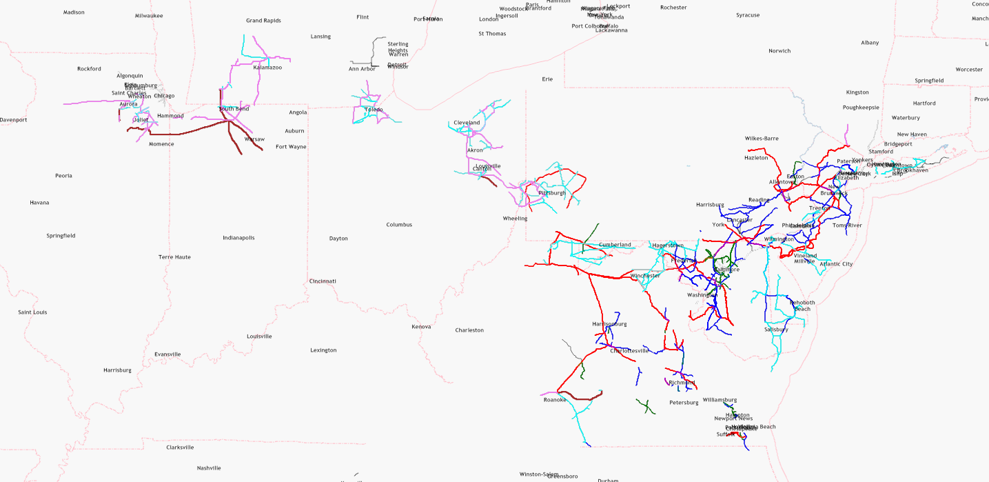
| US power lines are still incomplete | This map is intended to attract new mappers for some neglected areas. Since October 2010, this power network has grown remarkably, and each additional line may be considered as success. This map is neither a proof that black areas are perfectly mapped (Chicago has still some gaps which need to be added) nor a proof that white areas are completely unmapped. Toolserver's powermap has almost as many white spots as my simple map which I have made with Kosmos, so there must be some untouched areas. Anybody who wants to fill the white areas is welcome. Anybody who wants to leave the map as it is will be ignored. |
|
| Westover, Arlington, VA | It would be great if all streets looked like this one. |
|
| New contributors to OSM in Cleveland ! | Two years ago, Detroit was a TIGER desert. Good examples like Cincinnati are spreading like a seed as they encourage other mappers to do the same. |
|
| Road Classifications | Functional road classification is a good starting point for reclassification of OSM roads:
|
|
| US power lines are still incomplete | Update: there is also another powermap which covers the United States: http://toolserver.org/~osm/styles/?zoom=12&lat=40.81767&lon=-74.21297&layers=B000F0FF0000F0FFF0000T |
|
| US power lines are still incomplete | This map tries to visualize mapped and unmapped areas so that interested mappers can improve unmapped areas. For technical reasons, it does not focus on special features like power stations which are visualized in the following very detailed map: http://energy.freelayer.net/?zoom=8&lat=52.56802&lon=9.33476&layers=B00000 Rendering such a detailed map requires very good data (which is available for Northern Germany) and very much processing power. The map above is a very rough sketch in order to start a discussion about power mapping quality. |
|
| US power lines are still incomplete | Each black dot represents a pylon, each yellow dot represents a substation. Pylons prove that a human mapper has mapped there because TIGER lines do not include pylons. |
|
| Wie lange kann es dauern bis ein bestimmter Teil gerendert ist? | Der See war nicht als Fläche, sondern als unvollständiger Weg eingezeichnet! |
|
| Benennung von Wegen | path = begehbarer Weg (Vorschlag der deutschen OSM-Mapper)
Gruß FK270673 |
|
| OSM - Tensions? | Disagreements? Oh yes, especially in the German community! Try to ask the German forum for our disputed issues! Accepting ODbL - yes or no? City threshold - 50000, 80000 or 100000 inhabitants? Displaying brothels - yes or no?
Mapping county roads (Kreisstraßen) as primary or secondary roads?
Mapping cycleways separately - yes or no?
Mapping footpaths as footway or path?
Mapping motorroads as trunk or primary?
Using GPX or aerial photos? The OSM community is usually tolerant and hardly anybody has quit our project due to a disagreement. One user was banned because he refused to read his mails. Yours, FK270673 |
|
| theaterinmitte | Spam bedeutet "unerwünschte Werbung"! Das Tagebuch ist in erster Linie für Mitteilungen über neue Karteneinträge gedacht. Werbung ist hier eigentlich nicht erwünscht. Mitteilungen, die das eigene Hotel oder Restaurant betreffen (z.B. Inhaberwechsel oder geänderte Öffnungszeiten), sind ein Grenzfall, der in der Regel geduldet wird, weil es auch Auswirkungen auf die Karte hat. Gruß FK270673 |
|
| theaterinmitte | Willkommen in unserem Projekt! Bei uns darf jeder sein eigenes Hotel / Restaurant / Theater eintragen, das ist sogar ausdrücklich erwünscht. Zumindest den Namen des Theaters (name=XYZ) hättest Du aber noch eintragen können! Gruß FK270673 |
|
| More Newbie Road Madness | The highway tag for access roads depends on object importance:
There is no official guideline that distinguishes between big and small objects, but a tagging practice that looks good on the map. Tertiary roads are usually identified by their official route numbers (e.g. ref=CR 12 or ref=CR 179). The prefix (C, CH, CR or CTH) is depending on local usage. County routes are usually a very disputed issue:
We also collect a lot of other information like churches, parking lots, railroad crossings, restaurants, supermarkets, traffic signals and turning circles. Unfortunately, not every amenity is available in each editor, but JOSM offers many options. Feel free to ask whenever you find some missing or outdated features in the map. |
|
| Kartenexport | Hallo! Der Export von Kartenausschnitten funktioniert um so besser, je kleiner das ausgewählte Gebiet ist. Ein einzelnes Dorf kann man relativ leicht exportieren, ein Export der gesamten Weltkarte in einer Datei ist zwar (noch) nicht ausdrücklich verboten, zwingt aber jeden Server zwangsläufig in die Knie! Ganze Bundesländer bzw. Staaten bzw. Kontinente müssen von einem speziellen Download-Server, z.B. http://download.geofabrik.de heruntergeladen werden, weil die Export-Funktion für solche Aufgaben nicht gedacht ist. Irgendjemand missbraucht diese Exportfunktion (mit seinem Programm?) durch massenweises (automatisches) Herunterladen großer Datenmengen und erschwert damit allen anderen die Nutzung! Es gibt vier Möglichkeiten zum Export:
OSM-Daten sollte man nur herunterladen, wenn man sich mit JOSM oder Kosmos etwas auskennt oder breit ist, sich dort hineinzuarbeiten! Für blutige Laien ist eine einfache Grafikdatei weitaus besser geeignet! Gruß FK270673 |
|
| Started Editing Today, and Road Confusion. | Welcome to our project! When TIGER data was imported in 2007, all other roads (tiger:cfcc = A41) have been automatically converted to "residential" which is definitively wrong. The OSM classification of streets is roughly (!) following functional highway classification:
Paved tracks may be used e.g. on a golf course or in a national park. |
|
| OSM EMPOWERING? | - Mappers of commercial companies are working in order to earn their crust (basic and safety needs)
|
|
| OSM EMPOWERING? | Contracts, prices and money:
|
|
| OSM EMPOWERING? | Competition:
|